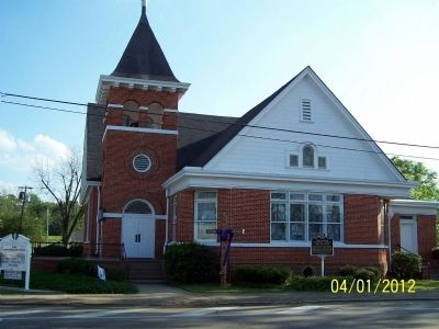
A congregation of the Methodist Episcopal Church, South existed in Elba even before Rev. Robert Shaw Rabb was assigned as the first minister to the Elba Circuit on December 15, 1853. This site was purchased in 1909 and the Church officially opened . . . — — Map (db m83274) HM
On South Main Street, on the right when traveling north.
Organized in 1883 by 13 charter members as Carmichael Chapel of Elba Circuit, the congregation originally worshipped in a brush arbor on the NW corner of N. Main and Lee Streets. The first two sanctuaries built in 1883 and 1893 were both located on . . . — — Map (db m54745) HM
On Alabama Route 27, on the right when traveling south.
Founded near Double Bridges Creek (LeCompte Place) three miles southwest of the present location. First Pastor: J. W. Bullard. Charter members: Mr. & Mrs. Thomas Mathis, Mr. & Mrs. Tom Barbee, Mr. & Mrs. Jack Nichols, Mr. & Mrs. Joe Jones, Mr. Bob . . . — — Map (db m83327) HM
On County Road 306 at County Road 316, on the left when traveling west on County Road 306.
The Antioch Primitive Baptist Church was established on August 28, 1868. In 1948, the church was rebuilt using the best lumber salvaged from the original church building and the nearby schoolhouse, which was located across the road. The land for . . . — — Map (db m301298) HM
On Alabama 189 at County Road 465, on the right when traveling north on Alabama 189.
On July 8, 1905, Charles H. and Cynthia Russell Rhoades
deeded 2 acres of land to the New Providence Primitive
Baptist Church and Rhoades Cemetery. This was the
fourth location for this church organized in the
early 1800s. The other locations . . . — — Map (db m302929) HM
On Alabama Route 51, on the left when traveling south.
Established 1858 Oldest official record is land deed
of December 29, 1853 for five acres to trustees I.T.
Law, William Mixson, William Dubose, Javor Dupee
and William Hendricks. Name was changed in 1868 to
Old Tabernacle after New Tabernacle . . . — — Map (db m204960) HM
On Mt. Pleasant Road (County Road 66) 0.3 miles east of County Line Road (County Road 48), on the right when traveling east.
Old Brick Church began in 1820 as the Mt. Pleasant Cumberland Presbyterian Church and met in a frame building which burned in 1824. The present building has undergone few changes since its construction in 1828 when the congregation was officially . . . — — Map (db m147370) HM
On Main Street 0.1 miles south of 1st Street, on the right when traveling south.
Side 1
The region's rich history of Methodism predates the creation of
Colbert County. Local Methodists helped raise $10,000 to persuade
the Tennessee Methodist Conference to build LaGrange College (4
miles SW), which opened in 1830. . . . — — Map (db m153325) HM
On County Line Road (Alabama Route 99) 0.2 miles north of Bethel Cemetery Road, on the left when traveling north.
The church was organized as Bethel Missionary Baptist Church on June 26, 1819, with Elder Theophilous Skinner serving as pastor. The church predates the creation of the state of Alabama by nearly 6 months. Bethel’s original was across County Line . . . — — Map (db m213754) HM
On Old Hwy 20 east of Morgan Drive, on the right when traveling east.
The town of Leighton was named in honor of the Reverend William Leigh, son and grandson of Revolutionary War veterans. He was born in Amelia County Virginia, Oct 4, 1790 and moved to Alabama about 1823. Leigh settled nearby at “Jeffers Cross . . . — — Map (db m278611) HM
On South Wilson Dam Road, on the right when traveling south.
Near the turn of the twentieth century, residents of Houston
Crossroads became concerned that their community had no church or
school. In 1895, John Schluttenhofer deeded an acre of land in the
southwest corner of the crossroads for the purpose . . . — — Map (db m208820) HM
This congregation was organized in July 1823 as Concord Church, later known as Union Church, then as Tuscumbia Baptist. Jeremiah Burns was the first pastor. It began meeting at this site about 1845 in a plain wooden building. The New England-style . . . — — Map (db m28564) HM
On East 4th Street at North Broad Street, on the right when traveling east on East 4th Street.
First Presbyterian Church was organized April 13, 1824, by Scots-Irish settlers. The sanctuary, erected in 1827, is the oldest in continuous use in Alabama. Its Georgian Gothic style remains essentially unchanged. The brick walls are laid in . . . — — Map (db m40429) HM
On North Dickson Street at East 3rd Street, on the right when traveling north on North Dickson Street.
This congregation was organized in the 1830's, with services being held in private homes and the Methodist meeting house. The present building was first used in October 1852 and completed the following year. During the Civil War, Union troops . . . — — Map (db m28422) HM
On County Road 6 0.2 miles west of County Road 43, on the right when traveling west.
Organized by Elder Alexander Travis in 1821 in a log building used as a school and house of worship in mid Brooklyn next to the Methodist Cemetery. Elder Travis served many years as preacher of Brooklyn Missionary Baptist Church. In 1860 Eli . . . — — Map (db m194554) HM
On Rural Street at Williams Avenue, on the right when traveling west on Rural Street.
In the fall of 1817 Reverend Alexander Travis settled his affairs in South Carolina and immigrated to Conecuh County, where, in the spring of 1818, Beulah Baptist Church was constituted. In rapid succession, Travis’ firm resolve and his devotion to . . . — — Map (db m86270) HM
On Park Street 0.1 miles north of Cemetery Avenue, on the right when traveling north.
Side 1
The church was organized March 15, 1845, in the home of George Brown. The organizing council consisted of Alexander Travis, Keidar Hawthorne, J.J. Sessions. Charter members were George and Mary Brown, Elbert and Louisa Joiner, . . . — — Map (db m81290) HM
On South Main Street (County Road 42) at Cemetery Avenue, on the left when traveling south on South Main Street.
The Louise Short Baptist Widows’ and Orphans’ Home, consisting of a 10-room brick residence and related buildings on 80 acres of land fronted on Main Street, Evergreen, for more than ¼ mile.
It was established by the Alabama Baptist State . . . — — Map (db m81293) HM
On Brown Hawkins Road at Fall Lane, on the left when traveling north on Brown Hawkins Road.
Side 1
Doctor Reverend Hillary James Hawkins, who was affectionately known throughout the community as “Brown,” dedicated most of his adult life to providing spiritual guidance to blacks in Evergreen and surrounding . . . — — Map (db m81292) HM
On County Road 85 at Hickory Tree Road, on the right when traveling south on County Road 85.
Greater Nazarene is the oldest and largest African American Baptist
congregation in Conecuh County. The church was established in 1875 by
formerly enslaved people. They met in a building near the home of
Joseph Howard, who served as a deacon. . . . — — Map (db m283849) HM
On Nymph Road (County Route 85) at Hickory Tree Road, on the left when traveling south on Nymph Road.
Stephen Decatur Miller Jr., namesake of a former governor and U.S. Senator from South Carolina, moved to rural Conecuh County in 1850. He brought with him to this place at least thirteen enslaved people. Within a decade, farming interests enriched . . . — — Map (db m305848) HM
On County Road 85 at Hickory Tree Road, on the right when traveling north on County Road 85.
Among the nearly four hundred graves in Nymph's Historic Nazarene
Cemetery are the unmarked resting places of enslaved men and women
brought to this rural Conecuh County community by their owner
Stephen D. Miller Jr. in 1850. These included . . . — — Map (db m283847) HM
On Alabama Route 22 west of Route 9, on the right when traveling west.
Peace & Goodwill Cemetery is Coosa County's first African American Cemetery to be placed on the prestigious Alabama Historic Cemetery Register. It provides powerful insights about the diligence and commitment of our African Ancestors. Family . . . — — Map (db m64587) HM
On South 3 Notch Street south of Dunson Street, on the left when traveling south.
Organized on December 5, 1901, by nine members
who met in the old Methodist Church on Church
Street. D.A. McArtan was elected as first deacon
and N. H. McDonald first elder. During the early
years, the church met in the old courthouse,
First . . . — — Map (db m283858) HM
On Glenwood Road (County Road 6) 1 mile east of North Glenwood Road (County Road 57), on the left when traveling east.
Constituted in 1833 about 1 mile northwest of this location with 10 charter members. The Church was admitted to the Conecuh River Baptist Association in November 1833. In 1863, the Church moved to this location on land bought from Benjamin Dorman . . . — — Map (db m72055) HM
On Turkey Creek Road near Campground Church Road ( Road 50), on the right when traveling south.
During the early years of the Methodist Church, lay
preachers journeyed into Alabama and established
churches. Church buildings were scarce so people
gathered under large trees, where they constructed
brush arbor tabernacles, known as "camp . . . — — Map (db m302973) HM
On Rutledge Street at St. Johns Street, on the right when traveling west on Rutledge Street.
In 1887, St. John Baptist Church was established under a brush arbor in
east Luverne. The congregation relocated to its present location when
George Foreman, a white resident, donated property to the church in 1893.
Years later, in 1937, a . . . — — Map (db m283917) HM
On Lee Street (State Road 10) 1 mile west of Montgomery Highway (U.S. 331), on the right when traveling west.
The Rutledge Primitive Baptist Church was built circa 1890, on land donated by Thomas Warren Shows and his family. The Rutledge Primitive Baptist Church was a member of the Ebenezer Primitive Baptist Association, which was formed in 1837. It was one . . . — — Map (db m72054) HM
On 4th Street Southwest at 5th Avenue Southwest, on the right when traveling east on 4th Street Southwest.
The first church in the City of Cullman was established on this block of land donated by the North and South Railroad in February 1874. Lots 154, 155, and 181 were granted to Henry Dietz, August Henning, and George Stoback as trustees of the . . . — — Map (db m33841) HM
On 2nd Avenue Southeast north of 6th Street Southeast, on the right when traveling north.
The first church at the town site of Cullman. Founded May 1, 1874, at the beginning of the second year of settlement.
An ethnic German church formed by immigrant families. Services held exclusively in the German language until 1932. In 1937, . . . — — Map (db m33840) HM
The Ave Maria Grotto
the work of
Brother Joseph Zoettl, O.S.B.
has been recorded in the
National Register
of Historic Places
by the United States Department of Interior 1984. — — Map (db m37452) HM
On Commercial Street at Bulldog Ln, on the right when traveling east on Commercial Street.
Trinity Evangelical Lutheran Church is the oldest Lutheran Church-Missouri Synod church building in Alabama still in use by its original congregation.
The Missouri Synod founded in 1857 and headquartered in St. Louis, Missouri, is a traditional, . . . — — Map (db m308729) HM
On U.S. 278 west of Wesley Avenue (County Road 1669), on the right when traveling west.
First Baptist Church of Holy Pond was organized in 1885 as Holly Pond Missionary Baptist Church. Charter members included the families of P.R. Tennison, William Jefferson Hazelwood, Bill House, Seaborn Shaw and Isaac Barnett. Over the course of the . . . — — Map (db m156417) HM
On County Road 846 north of County Road 844, on the right when traveling north.
Early settlers to Cullman County established Shady Grove Methodist Episcopal Church as a brush arbor in the 1870s on land homesteaded and donated by Richard McCain. Trustees, J. J. McKissack, W. H. Martin, J. C. Vickery, J. W. Kilgo, together with . . . — — Map (db m34244) HM
On Kirby Richardson Road (County Road 13) 0.2 miles south of County Road 15, on the right when traveling south.
Union Presbyterian Church. Organized by John Warnock, East Alabama Presbytery, September 1843, its mother church being Pea River Presbyterian (Barbour County). Founders, who migrated from Scotland to Argura, North Carolina, and then to Union . . . — — Map (db m183475) HM
On Clio Road (State Highway 51) at Powell Circle, on the right when traveling east on Clio Road.
Born in Houston County, Georgia, Civil War veteran, farmer, merchant and civil leader, founder of Dean Station, 1888, the beginning of Township of Charlton which was later united with Ariosto
and named Ariton, donor of land for first school . . . — — Map (db m289264) HM
On Alabama Route 92, on the right when traveling east.
Organized May 26, 1849
First Pastor: Ruben E. Brown
First Deacons: William P. Bryan, Jonas P. Bell
Charter Members: William Green, David Kelly, Kader Powell, Elizabeth Kelly, Ardilla Green, Winny Lacy, Bill Fowler, nancy Fowler
Bellwood, Cool . . . — — Map (db m39124) HM
On County Road 67 at County Road 16, on the left when traveling north on County Road 67.
The Christian Hill Congregational Church was established by the Rev. Samuel Long in 1895. After serving the community for more than 50 years, the church was inactivated and the building dismantled in the early 1970's. — — Map (db m205354) HM
On Oates Drive east of College Street ( Route 123/134), on the right when traveling east.
Organized in 1898 under the Christian leadership of A. W. Tate and Newton Baptist Church. The property was later given to the Baptists of southeast Alabama, adopted by nine Baptist Associations. In 1907 Baptist State Convention agreed to accept . . . — — Map (db m79000) HM
On Andrews Avenue (Alabama Route 249) west of Meadowlake Drive, on the right when traveling west.
In loving memory of my grandfather Elisha Matthews who made the first verbal grant of this property in 1829. In consideration of love and affections for the church and community I.W.E. Martin, hereby give, grant and convey the land enclosed by . . . — — Map (db m213370) HM
On Andrews Avenue (Alabama Route 249) west of Meadowlake Drive, on the right when traveling west.
150 yds. west. The first house, built of round logs, with wooden pegs for nails, dirt floor and puncheon seats, was replaced by the present building in 1852. Used for a voting place, a school, and a church.
Originally non-denominational, it . . . — — Map (db m213369) HM
Restored to its original pioneer condition in 1980 by descendants of
William A. "Billy" Byrd
1850-1931
and wife Ophelia Dowling Byrd
1854-1931
This is to certify that Claybank Log Church which has been selected as a landmark . . . — — Map (db m213406) HM
On Marley Mill Road (County Route 36) east of County Road 233, on the right when traveling east.
Longstreet Cemetery contains six separate cemeteries that were moved to this location in August 1942 during the construction of Fort Rucker. The property where the cemeteries are now located was the former site of Longstreet School. Cemeteries moved . . . — — Map (db m181072) HM
On South Union Avenue (Alabama Route 123) at West College Street, on the right when traveling south on South Union Avenue.
Ozark Baptist Church
This church was organized August 13, 1848, under the leadership of Rev. U.H. Parker at the home of William Andrews, two miles east of Ozark, and called Andrews Church. It was renamed Union Baptist Church in 1852 and . . . — — Map (db m132529) HM
On North Young Avenue at East Broad Street ( Route 105), on the left when traveling south on North Young Avenue.
Pleasant Grove Primitive Baptist Church
Pleasant Grove Primitive Baptist Church, first called Zion Hill, was organized on August 28, 1841 on a site two miles east of here on land on a site two given by the Carroll family. Most of the . . . — — Map (db m213205) HM
On County Road 33, on the right when traveling north.
In 1833 A.D. Elias Snell and wife received the God given forsight which led them to give this quarter section of land for the establishment of Asbury Methodist Church — — Map (db m204954) HM
On Morgan Church Road (County Road 333) 0.1 miles east of County Road 60, on the left when traveling east.
Morgan Baptist Church. Organized in 1913, Morgan Baptist Church traces its origins to nearby Beersheba Primitive Baptist Church (ca. 1850) and its successor, Englewood Church. The congregation began meeting in the Morgan Schoolhouse, which . . . — — Map (db m166532) HM
On County Route 41 at County Route 68, on the left when traveling south on County Route 41.
(side 1)
Listed below are the known pastors of Peniel Baptist Church since its establishment about 1852. Middleton Brooks, S. Hargrove, W. A. Cumbie, Ransom C. Deal, Sr., R. Cass Deal, R. B. Arnold, J. W. Phillips, F. M. Shirah, M. A. . . . — — Map (db m71587) HM
On County Road 23, on the left when traveling south.
This Church was organized August 3,1868, under a brush arbor, by Elias John McLendon and John Bradley.The first building was log house near the cemetery west of the Edd Dykes's place. First known as "Antioch" the church was later named Salem. On . . . — — Map (db m182138) HM
On Alabama Route 22, on the left when traveling east.
The Beloit Industrial Institute was founded in 1888 by Industrial Missionary Association, an area subdivision of the American Missionary Associations. The President of the Association, Dr. Charles B. Curtis, was a Presbyterian missionary and . . . — — Map (db m83504) HM
On Cahaba Road south of Capitol Street, on the right when traveling south.
St. Luke's Episcopal Church, completed
in 1854, was very different from the
other churches in Cahaba. Its Gothic
Revival style stood in stark contrast to
the fairly standard Greek Revival form
used by the Methodists and Baptists. . . . — — Map (db m274276) HM
On Vine Street 0.1 miles south of Capitol Street, on the left when traveling south.
St. Luke's Episcopal Church was built at Cahawba in 1854 but was dismantled and moved sometime after 1884 but before 1888. It was reassembled fifteen miles away in a rural community called Martin's Station. The raised outline before you indicates . . . — — Map (db m83510) HM
On Mulberry Street south of First South Street, on the left when traveling south.
These ruins were once a place of worship for members of the Methodist Episcopal Church South. Built in 1849, it was the first single denomination church in Cahawba. An earlier church for the common use of all denominations was erected about 1840. . . . — — Map (db m112410) HM
On Vine Street, on the left when traveling south. Reported permanently removed.
St. Luke's was consecrated in 1854. It was an outstanding example of the Gothic Revival style, popular at the time. The contractor closely followed designs in a widely circulated book, Rural Architecture, published in 1852 by the celebrated . . . — — Map (db m75922) HM
On Mill Street South, on the right when traveling south.
Frank Orr and his brother, William, settled Orrville in the early 1800's with a very strong religious group of people. A church was soon organized and a place of worship was built on this site in 1846. The church was known as the Methodist Episcopal . . . — — Map (db m23003) HM
On County Road 12 0.1 miles east of County Road 7, on the right when traveling east.
A Cumberland Presbyterian church named Mt. Pleasant was organized here about 1821 by Rev. William James Moor, a missionary from the Elk Presbytery of Tennessee. Renamed Mount Carmel in 1827, this church provided early leadership for the Ala. . . . — — Map (db m75777) HM
On Martin Luther King Street 0.1 miles south of Clark Avenue, on the right when traveling south.
Brown A.M.E. Chapel (in front of you) served as a safe haven for supporters during the voting rights campaign. Pastor P.H. Lewis and his congregation courageously broke the injunction prohibiting African Americans from holding mass meetings, making . . . — — Map (db m131995) HM
On Lauderdale Street at Alabama Avenue, on the right when traveling north on Lauderdale Street.
"Of all the nights of my experience, this is most like the horrors of war — a captured city burning at night, a victorious army advancing, and a demoralized one retreating. ...this Sunday night nearly gone, will be remembered. If there is a merciful . . . — — Map (db m82744) HM
On FD Reese Street south of Philpot Avenue, on the right when traveling north.
As president of the Dallas County Voters League. Dr. Reese wrote and signed the 1964 letter inviting Rev. Martin Luther King, Jr. and the Southern Christian Leadership Conference (SCLC) to Selma to join the struggle for civil rights. On March 7, . . . — — Map (db m297245) HM
On FD Reese Street south of Philpot Avenue, on the right when traveling north.
In 1922, Rev. Love Tolbert founded Ebenezer in a former dance hall on the corner of St. Phillips Street and Philpot Avenue in Selma. After Rev. Tolbert's brief tenure. Rev. Jerry McGinnis served as interim pastor until Rev. Abraham White was . . . — — Map (db m297248) HM
On Martin Luther King Jr. Street at JL Chestnut Jr Boulevard, on the left when traveling north on Martin Luther King Jr. Street.
First Baptist was the first church in Selma to open its doors to members of the Dallas County Voters League as well as to young activists from the Student Nonviolent Coordinating Committee. From 1963 to 1965, under the leadership of Reverend M.C. . . . — — Map (db m112366) HM
Rev. James J. Reeb, an Army Veteran and Unitarian minister from Casper, Wyoming, was working in Boston when Rev. Martin Luther King, Jr. appealed for clergymen of all faiths to come to Selma to protest the violence that occurred at the Edmund Pettus . . . — — Map (db m37683) HM
On Business U.S. 80 north of Old Montgomery Highway, on the right when traveling north.
Leader of
The Selma-Montgomery March
"Bloody Sunday", March 7, 1965
He Fed the Hungry
"Unbossed and Unbought"
1926-2000
Presented by
SCLC/W.O.M.E.N. Inc.
Women's Organizational Movement for Equality . . . — — Map (db m111689) HM
On Washington Street at Alabama Avenue, on the right when traveling north on Washington Street.
After the "Bloody Sunday" attack on Civil Rights marchers in Selma on March 7, 1965, Rev. Reeb joined the nationwide call from Dr. King's plea for ministers of all races and religions to convene in Selma. Rev. Reeb joined a march led by Dr. King on . . . — — Map (db m291369) HM
On Marie Foster Street at Philpot Avenue, on the right when traveling south on Marie Foster Street.
Prior to 1960. Northern Heights Presbyterian Church was known as Sylvan Street Presbyterian Church. which began in 1896 as a Sunday school mission sponsored by the First Presbyterian Church of Selma. The church formally organized in 1900. Rev. . . . — — Map (db m297251) HM
On Martin Luther King Jr. Street 0.1 miles north of St. Johns Street, on the left when traveling north.
The shooting of Jimmie Lee Jackson in nearby Marion, Alabama, transformed Brown Chapel from a sanctuary into a staging area for the Selma march, In a passionate sermon SCLC worker James Bevel suggested making a pilgrimage to the State Capitol to . . . — — Map (db m112364) HM
On Lauderdale Street at Selma Avenue, on the right when traveling north on Lauderdale Street.
Side A The original church, built one block south of the present site, was consecrated in 1843 by Bishop Leonidas Polk. In 1861, the second Bishop of Alabama, the Rt. Rev. Richard H. Wilmer, was elected there. During the Battle of Selma, St. . . . — — Map (db m37691) HM
On Broad Street (Business U.S. 80) at Minter Avenue, on the right when traveling south on Broad Street.
In January 1885, Dr. Edward M. Brawley, President, Alabama Baptist Normal and Theological School (now Selma University) formed Tabernacle Baptist Church to be an integral part of the students' Christian formation and education. Significant . . . — — Map (db m82034) HM
On Broad Street (Business U.S. 80) at Minter Avenue, on the right when traveling south on Broad Street.
Tabernacle Baptist Church was founded in 1885, and in March of that year, the congregation purchased this site. Built in 1922 under the leadership of Dr. David Vivian Jemison, the current church features bricks from the original church building . . . — — Map (db m83677) HM
The earliest Jewish settlers came to Selma prior to the Civil War, some as early as the 1830’s. A group of Jewish citizens assembled as the Mishkan Israel Congregation and began meeting in private homes in 1867. The congregation was formally . . . — — Map (db m37677) HM
Edgar Cayce (1877-1945), was internationally accepted as an extremely gifted psychic. An humble man, he never profited materially from his psychic ability, but used it to help “make manifest the love of God and man.” Operated his photography . . . — — Map (db m83680) HM
On Martin Luther King Jr. Street at J L Chestnut Boulevard, on the left when traveling north on Martin Luther King Jr. Street.
By early 1964, the Dallas County Voters League (DCVL) and Student Nonviolent Coordinating Committee's (SNCC) efforts to organize for voting rights had reached a turning point. In July 1964 Judge James Hare, pressured by Selma law enforcement to . . . — — Map (db m112369) HM
On State Highway 22 at County Road 65, on the right when traveling south on State Highway 22.
Established in 1816 by eight families from Rocky River Presbyterian Church in Mecklenburg County, North Carolina.
In 1859 this two-story brick building replaced original wooden structure.
Sanctuary and former slave gallery are on second . . . — — Map (db m83683) HM
Near County Road 457 0.4 miles east of County Road 7.
Named for a nearby pair of springs, Sister Springs Baptist Church was
organized on January 16, 1823. The event was recorded in the church
minutes thus, "the following Brethren to wit: Thomas and William Herrod
being called to work on . . . — — Map (db m286977) HM
On County Road 37 north of County Road 65, on the right when traveling north.
Established circa 1819 as Childers Meeting House on land given by George Childers. Patent for the land was issued to George Childers March 16, 1819. This Methodist Church was later known as Childers Chapel. Church burned in 1842. Congregation . . . — — Map (db m37646) HM
On Main Street north of County Road 16, on the right when traveling north.
Congregation was organized as early as 1837, first under the charge of Charles McLeod and next, Asbury H. Shanks. Contract for the present building was let October 23, 1844, and the building was dedicated on October 5, 1845. Greenberry Garrett was . . . — — Map (db m37647) HM
On Gault Avenue North (U.S. 11) east of 4th Street, on the right when traveling east. Reported missing.
The mission was established in 1823 by the American Board of Missions to further education and Christianity among the Cherokee Indians. Mission operated until the Indian removal in 1838.
Grave site of Reverend Ard Hoyt, first superintendent, . . . — — Map (db m261861) HM
On County Road 165 at County Road 617, on the right when traveling east on County Road 165.
The chapel was built by Col. Milford W. Howard in memory of his first wife, Sally A. Lankford Howard and by the mountain people.
The back of the chapel is a large boulder and stones from Little River were used to construct the altar. The church is . . . — — Map (db m244134) HM
Near Interstate 59 1 mile north of County Road 140, on the right when traveling south.
A Cherokee town founded 1770. Situated on Big Wills Creek, named for a half-breed chief, Red-Headed Will. A place of importance in the Cherokee Territory, it was the home of Sequoyah, inventor of the Cherokee Alphabet; John Ross, the last chief of . . . — — Map (db m213367) HM
On Lightwood Road north of Holtville Road ( Route 111), on the right when traveling north.
In 1820, Elisha Milton Cain founded Cain's Chapel, one of the oldest continuous church congregations in the River Region. Cain moved from Orange County, South Carolina to the Pine Flat area in 1817. In 1820, he moved to this area and constructed . . . — — Map (db m263960) HM
On Main Street 0.1 miles south of Route 14, on the right when traveling north.
This notable Greek Revival structure was completed in the late 1840's on land donated by Eli Robinson. The congregation was established 1828-1830 and the first church, built of logs, was located c. 1 mile east of here. Charter members were: Rev. . . . — — Map (db m71178) HM
On Jordan Avenue near Barnett Boulevard ( Route 14), on the right when traveling north.
The history of this church encompasses the span of worldwide Methodism from the time of John Wesley to the present. A Methodist Society was organized in Tallassee in 1853 by 15 charter members who gathered in the "White Store," a mill company . . . — — Map (db m160158) HM
On West Bridge Street (Alabama Route 212) at Dozier Street, on the right when traveling east on West Bridge Street. Reported missing.
Baptists settlers scattered along the Coosa River Valley established the church May 26, 1821. For the first twenty years, it was mostly known as the Coosa River Baptist Church. Migrating members sought several locations for the church, finally . . . — — Map (db m304421) HM
On West Bridge Street (Alabama Route 212) at North Bridge Street ( Route 111), on the right when traveling west on West Bridge Street. Reported missing.
Built, 1856, dedicated 1857, combining exterior Gothic style with Greek Revival interior. Original part designed as a rectangular block. Wings were added on eastern and western sides in the middle 1900's. At that time a choir rail replaced original . . . — — Map (db m67943) HM
On Mathis Road west of Marshell Road, on the left when traveling west.
The New Prospect Baptist
Church, Wetumpka has been
designated as a significant
African American historic
site by the Black Heritage
Council of the Alabama
Historical Commission. — — Map (db m245698) HM
On West Tuskeena Street at North Broad Street, on the right when traveling west on West Tuskeena Street.
Completed in 1854, this building was the third Methodist Church building erected in Wetumpka and served both black and white congregations. Transitional exterior and interior architecture features elegant simplicity of Greek revival styles. . . . — — Map (db m83725) HM
On Alco Drive 0.2 miles south of Blacksher Lane, on the right when traveling south.
This cemetery was established in 1854 when Pilgrims' Rest Baptist Church was founded across the road on September 17 in that same year. The cemetery remained prominent in Alco even though the original congregation moved and Alco Methodist Church . . . — — Map (db m130672) HM
On East Street at Northeast Street, on the left when traveling east on East Street.
On November 5, 1909, a group of worshipers gathered in the Congregational Church on the corner of St. Joseph and Evergreen Streets and organized the Second Saint Siloam Missionary Baptist Church. On June 10, 1910, the Second Saint Siloam Missionary . . . — — Map (db m130671) HM
On Dr. Van Avenue (Houston Street) just south of College Street, on the right when traveling north.
In 1878, Rev. James Lazaruth Bryars planted First Baptist Church in the community that would eventually come to be known as Flomaton. The bell was in the original wooden church building located on Palafox Street, and it was moved to the current . . . — — Map (db m146902) HM
On Lamosa Street at Misella Street, on the right when traveling east on Lamosa Street.
A pre Civil War structure, this is the oldest church building remaining in Escambia County, Alabama. Confederate veterans related stories that mules and horses were sheltered inside during harsh winter months. Circuit riders served the church in the . . . — — Map (db m84388) HM
On Bradley Road (County Road 4) at Hickory Head Road, on the left when traveling east on Bradley Road.
Organized in 1825 by early settlers John, Samuel, Peter, and
Noah Parker, the first Church was a small log cabin located
along Silas Creek, approximately two and one half miles NE
from this present site. Alexander Travis, a South Alabama
Circuit . . . — — Map (db m194561) HM
On 6th Avenue at 4th Street NW, on the right when traveling north on 6th Avenue.
In 1851 twelve Methodists met in Newton (later Attalla) to plan a Methodist Episcopal Church. A crude log building on North Fifth Street served as the first church. In 1861 and again in 1882 the church relocated on Fifth to accommodate the growing . . . — — Map (db m83731) HM
On Chestnut Street at South 8th Street, on the right when traveling west on Chestnut Street.
A religious school was organized in the Nadler home for the children of 10 Jewish families in 1903. From these roots came the first formal worship service in 1908.
The cornerstone for the sanctuary was laid on March 8, 1922 with both Jewish and . . . — — Map (db m51208) HM
On South 1st Street at South 3rd Street, on the right when traveling north on South 1st Street.
On January 25, 1925 the Sisters acquired the 25 - bed Gadsden General Hospital on Chestnut Street and renamed it Holy Name of Jesus Hospital. The Hospital grew under the leadership of the Founders, Father Thomas A. Judge, C. M. and Mother Mary . . . — — Map (db m39141) HM
The North Alabama Conference of the United Methodist Church was organized on this site in the Methodist Episcopal Church, South of Gadsden, Alabama
November 16, 1870
Bishop Robert Paine, presiding
The Centennial Convocation of the Conference . . . — — Map (db m83739) HM
On Rainbow Drive (U.S. 411) at Cemetery Road, on the right when traveling east on Rainbow Drive.
Oldest church in Etowah County. Organized Saturday, April 2, 1831, at Harmony Meeting
House, which was built in 1821, by Edmond Jones at this location.
It was here that the Wills Creek Baptist Association was organized in 1836, Harmony
being . . . — — Map (db m205239) HM
On Rainbow Drive (U.S. 411) east of Peteet Street, on the right when traveling east.
In the summer of 1784 William Jones and his two young sons were among a group of families from Georgia making their way through this area following the Old High Town Path. They camped here near a large spring and planned to continue their journey . . . — — Map (db m156371) HM
24494 entries matched your criteria. Entries 101 through 200 are listed above. ⊲ Previous 100 — Next 100 ⊳