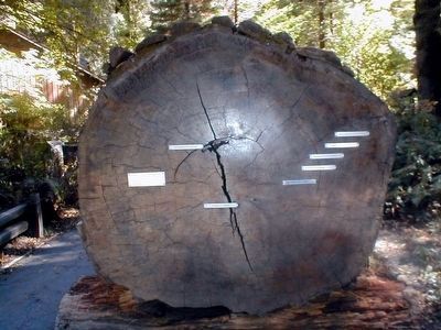
In 1148 this tree began growing near Jordan Creek at the north end of the “Avenue of the Giants”. It was 839 years old when it fell in 1897. Average Diameter at Base—9 feet; Height of Tree—300 Feet; Age of Cross . . . — — Map (db m87846) HM
On Three Flags Highway (Highway 395) at County Route 168, on the right when traveling north on Three Flags Highway.
This Giant Sequoia is reported to have been planted to commemorate the opening of Westgaard Pass to automobile traffic. The tree was named in honor of President Theodore "Teddy" Roosevelt. — — Map (db m54428) HM
You are standing before San-shi-en, or 3-4
Garden. Water once flowed over these silent
stones, soothing troubled spirits and easing
the monotony of long mealtime lines.
Designed and built by internees, mess hall
gardens served as a source . . . — — Map (db m288410) HM
On U.S. 395 0.3 miles south of Pangborne Lane, on the right when traveling south.
This English Pedunculate Oak tree
originated in Sherwood Forest England.
Around the turn of the century a small
sprout was sent to Lone Pine. A member
of the Fred French family planted the
sprout on this original site, a part of the
old Harvey . . . — — Map (db m221404) HM
Owens Lake is now a Key Migratory Stopover
In the late 1800s, the shoreline of Owens Lake shifted at the hands of people. Even before the City of Los Angeles began diverting water from Owens River, farmers had tapped its tributaries, . . . — — Map (db m221862) HM
Near China Ranch Road south of Furnace Creek Road.
In the 1890's a Chinese man named Ah Foo came to this canyon from the Borax Works in Death Valley. He developed a successful ranch, raising livestock, hay, fruits and vegetables to help feed the local silver miners and their draft animals. The . . . — — Map (db m72929) HM
Near White Mountain Road 10 miles north of Route 168, on the right when traveling north.
In 1953, Dr. Edmund P. Schulman was searching this grove of
bristlecones for old trees to extend his tree ring chronology. With
his discovery of the "Pine Alpha" tree, he became the first person
in the world to document 4,000-year-old trees. . . . — — Map (db m304420) HM
On Main Street south of First Street, on the right when traveling north.
The original building was destroyed in the fire of 1924. Six months later the present building opened as a hardware store. It has the pressed concrete walls and pressed tin ceiling typical of fire measures taken when the town was rebuilt.
As . . . — — Map (db m49116) HM
On Altadena Drive at Lake Avenue, on the right when traveling east on Altadena Drive.
John Woodbury, founder of Altadena with his brother
Fred, first saw our town's iconic conifer, Cedrus
deodara, touring Italy in the 1870s. After the United
States Department of Agriculture assured him
the Himalayan native would grow here, he . . . — — Map (db m251768) HM
On Santa Rosa Avenue at Alameda Street, on the right when traveling north on Santa Rosa Avenue.
The 135 Deodar Cedar trees were planted in 1885 by the Woodbury Family, the founders of Altadena. First organized by F.C. Nash in 1920, the "Mile of Christmas Trees" has been strung with 10,000 lights each holiday season through the efforts of . . . — — Map (db m143798) HM
Near Mount Wilson Toll Road 3 miles east of Pinecrest Drive.
This area was originally homesteaded by John Henninger
in 1886. From 1902-1907 the United States Forest Service
maintained on the flats an experimental nursery, in charge
of Arthur Lukins. The results of these experiments, as
shown by the . . . — — Map (db m272909) HM
Near Slide Peak Trail 4 miles west of Old Route 99.
National Historic Lookout Register
This certificate officially recognizes
Slide Mountain Lookout,
Los Angeles County, California,
as meeting those standards of historic and cultural significance
established by the American . . . — — Map (db m272373) HM
Near Vetter Mountain Road 2 miles west of Angeles Crest Highway ( Route 2).
Welcome to the Vetter Mountain Fire Lookout Tower in the Angeles National Forest. As you can see from the spectacular vistas, Vetter Mountain is an ideal location for a fire lookout.
The Vetter Mountain Lookout was constructed in 1937 and . . . — — Map (db m201274) HM
Near Angeles Crest Highway (California Route 2) 26 miles north of Interstate 210.
Built in 1900 alongside the West Fork of the San Gabriel River and north of Mt. Wilson, the historic cabin was the first ranger station built in California with federal government funds - $75. In the late 1920's, new roads into the mountains . . . — — Map (db m154560) HM
On Mt Mooney Road near Angeles Crest Highway ( Route 2), on the right when traveling north.
This grove presented by the
California State Society of the
Daughters of the American Revolution
in honor of
Mrs. John Whittier Howe Hodge,
State Regent 1938-1940,
commemorating the
D.A.R. Society's Fiftieth Anniversary. — — Map (db m291772) HM
Near Baldwin Avenue 0.3 miles south of Colorado Boulevard, on the right when traveling south.
Once common across the globe, cycads are now
threatened or endangered in the wild. Explore our
diverse collection and learn about these impressive plants.
Age of Cycads
The Jurassic Period is famous for its fantastically large . . . — — Map (db m198164) HM
Near Baldwin Avenue south of Interstate 210, on the right when traveling south.
Today’s Los Angeles County Arboretum & Botanic Garden blends history and horticulture in a landscape ripe with cultural nuance, allowing history to be sampled in its native setting and savored as an integral link between humans and the land they . . . — — Map (db m143271) HM
Near Baldwin Avenue 0.3 miles south of Interstate 210, on the right when traveling south.
Constructed by Elias Jackson ('Lucky') Baldwin in 1881. Designed by A.A. Bennett, and intended for entertaining. There being no kitchen, meals were served from the nearby adobe (built by Hugo Reid in 1839) where Baldwin actually lived. Restored and . . . — — Map (db m153410) HM
On Wilshire Boulevard at Santa Monica Boulevard, on the right when traveling east on Wilshire Boulevard.
Beverly Hills Nurseries, once located at the "point" of
Wilshire and Santa Monica boulevards, was one of the
largest retail nurseries in California. Dating to 1906,
it was created by the Rodeo Land & Water
Company to supply the City's vast . . . — — Map (db m279285) HM
On Elden Way 0.1 miles north of North Crescent Drive, on the right when traveling north.
United States Department of the Interior National Register of Historic Places.
Beverly Hills Local Landmark.
Constructed in 1911. — — Map (db m148656) HM
The Meadow Park townhome community is situated just south of the foothills
of the San Gabriel Mountains with a clear view of Mt. San Antonio,
colloquially referred to as Mt. Baldy For nearly a century prior to its
development, this plot of . . . — — Map (db m266634) HM
On Indian Hill Boulevard north of 8th Street, on the right when traveling north.
Once an orange grove and home of the Herman and Bess Garner
family, this site was purchased in 1946 to serve as the city's first
community park. The Garners were business and educational leaders
and owners of the Padua Hills Theatre. The citizens . . . — — Map (db m149926) HM
On 162nd Street at Harvard Boulevard, on the right when traveling east on 162nd Street.
This is a fourth generation of the elm tree under which General
George Washington took command of the Continental Army on July 3, 1775;
and the Declaration of Independence was first read to the people of Cambridge, Massachusetts. — — Map (db m164425) HM
On Mountain Street, on the right when traveling west.
Miss American Green Cross was originally dedicated on May 4, 1928 to represent the American Green Cross Society. The early environmental organization was dedicated to the "saving of American's greatest asset-trees". The first chapter of the Society . . . — — Map (db m56198) HM
On South Santa Fe Avenue at West Colorado Avenue, on the right when traveling south on South Santa Fe Avenue.
The Big Tree was planted in the late 1880’s by Mr. Edgar J. Owens, one of Glendora’s early residents. The tree, botanical name Ficus Macrophylla, is commonly called Moreton Bay Fig and is named after the Moreton Bay region of Australia where the . . . — — Map (db m127852) HM
On East Bennett Avenue at Minnesota Avenue, on the left when traveling east on East Bennett Avenue.
Planted in 1901 by the R.W. Hamlins, early citrus growers, the Glendora bougainvillea is the largest growth of this exotic plant in the United States. The parent stock was brought to California by a whaling ship about 1870, and the vines survive as . . . — — Map (db m127847) HM
Near Mauna Loa Avenue 0.5 miles east of Glendora Avenue.
The Rain Bird horizontal action impact drive sprinkler head was invented in
1933 by Orton Englehardt, a citrus grower and native of Glendora. The design
offered slow rotation and uniform watering, benefits long sought by local
irrigators. . . . — — Map (db m146402) HM
Near Descanso Drive south of Verdugo Boulevard, on the right when traveling south.
Dedicated in memory of Helen Steele Pratt, 1883-1965. Devoted naturalist, nature teacher and counselor, whose efforts led to the
adoption of the California Quail as the California State Bird. — — Map (db m118494) HM
Near Descanso Drive 0.1 miles south of Verdugo Boulevard, on the right when traveling south.
Private estate becomes public treasure
Newspaperman E. Manchester Boddy (1891-1967) purchased the land that is now Descanso Gardens in 1939. The 165-acre Boddy estate became a public botanical garden when LA County acquired it in 1953. . . . — — Map (db m152511) HM
Near Descanso Drive 0.1 miles south of Verdugo Boulevard, on the right when traveling south.
Our Storied Past
Sharing cultures, creating community.
This Japanese-style garden opened in
1966, a time of heightened interest
in Japanese art and culture in the US. It
includes elements of four different types
of Japanese . . . — — Map (db m254439) HM
Near Angeles Crest Highway (California Route 2) 8.3 miles north of the Foothill Freeway (Interstate 210), on the left when traveling north.
This was the first National Forest in the State of California, second in the United States. Created by proclamation, December 20, 1892, by President Benjamin Harrison. The first name given to the forest was "San Gabriel Timberland Reserve." It was . . . — — Map (db m143501) HM
On 3rd Street at G Street, on the right when traveling east on 3rd Street.
These deodar cedar trees which were planted on Third Street by Hubert “Scubie” Mills have been designated heritage trees in his honor. — — Map (db m190921) HM
On 3rd Street at G Street, on the right when traveling east on 3rd Street.
This Craftsman home, built
in 1912 by Mace and Adele
Doutt, was purchased in 1918
by Isaac Eikenberry and
remained in the Eikenberry
family until 1974, a total of
56 years. The large bur oak
tree grew from an acorn
which Eikenberry . . . — — Map (db m190938) HM
Near Topanga Canyon Boulevard at Vanowen Street, on the right when traveling north.
Trees have always been an important consideration at Canoga Park High School since its founding in 1915. Many varieties of beautiful trees have been planted on campus over the years including the majestic Coast Redwood, (Sequoia Sempervirens), the . . . — — Map (db m135071) HM
Near Glendale Boulevard at Park Avenue, on the right when traveling north.
Aimee Semple McPherson (1890-1944) founded the International Church of the Foursquare Gospel and was a well-known figure in Los Angeles. After her founding of the Angelus Temple in 1923, the population of the Echo Park neighborhood greatly . . . — — Map (db m122445) HM
On Louise Avenue just south of Ventura Boulevard, in the median.
Declared Historic Cultural Monument No. 24 by the Cultural Heritage Board, Municipal Arts Department, City of Los Angeles.
newer plaque, now missing:
Lang Oak
Encino's 1000-year-old oak,
trunk diameter 24 . . . — — Map (db m165309) HM
After a fire in 1971, which left this hilltop scorched and blackened, Amir Dialameh
climbed to the top of this hill, carrying by hand most of the plants and trees we
enjoy in the garden today. Over the years, some of those trees Amir hauled . . . — — Map (db m177491) HM
On Selma Avenue east of Vine Street, on the right when traveling east.
The Squaw Man — a six reel western melodrama — is the first feature
length film to be shot literally in Hollywood. Several of the scenes
were filmed in the Lasky Barn on this location. It was first released
in 1914. DeMille successfully . . . — — Map (db m240150) HM
Near Latimer Road north of Hilltree Road, on the left when traveling north.
This grove was planted ca 1880 by Abbot Kinney, the founder of Venice, CA and developer of the Venice Canals. This land was acquired for the City of Los Angeles, spurred by fundraising by the Santa Monica Canyon Civic Association (SMCCA) in the . . . — — Map (db m179981) HM
On Latimer Road at Hilltree Road, on the left when traveling north on Latimer Road.
In 1887, the State Board of Forestry established the nation's first experimental forestry station. Located in Rustic Canyon, the station tested exotic trees for planting in California, established plantations for management studies, and produced . . . — — Map (db m119875) HM
On National Boulevard at Military Avenue, on the right when traveling east on National Boulevard.
Planted circa 1875. Declared Historic Cultural Monument No. 19 by the Cultural Heritage Board, Municipal Art Department, City of Los Angeles. — — Map (db m188853) HM
On Exposition Boulevard 0.3 miles east of Vermont Avenue, on the right when traveling east.
From Sin to Science, A Park For The People
For decades into the 20th century, Los Angeles not only fed the world’s imagination with films and television — it fed the world’s bellies, too.
Los Angeles County prided itself on . . . — — Map (db m216967) HM
On Figueroa Street at 39th Street, on the right when traveling south on Figueroa Street.
This historic palm tree stood for more than 25 years at the entrance of the Southern Pacific Station. At this railroad portal of the city it became a familiar landmark to many thousands of Los Angeles and Southern California citizens and . . . — — Map (db m155323) HM
On Figueroa Street south of Adams Boulevard, on the right when traveling south.
The Auto Club Moreton Bay Fig Tree centennial 1894-1994.
The Automobile Club of Southern California honors the
Charles C. Chapman family for the vision to plant this
Moreton Bay Fig Tree in their garden in 1894. Since the
Auto Club built . . . — — Map (db m252970) HM
This area was originally planted with annual and perennial flowers. Roses were tested, conditions proved to be satisfactory, so in 1927 the Rose Garden was established. It contains approximately 15,000 bushes of 145 varieties. The Los Angeles . . . — — Map (db m215943) HM
On Hellman Way at McCarthy Quad, on the right when traveling east on Hellman Way.
This library garden courtyard and fountain are dedicated to the memory of Carolyn Craig Franklin (1919–1993).
They were donated by Dr. Carl Franklin, Vice President Emeritus and Professor of Law at USC, and their four children: Craig, . . . — — Map (db m130210) HM
Early Life
As a young man, Theodore Payne (1872-1963) immigrated to Southern California from England to pursue a career in horticulture. He fell in love with the local flora, especially our wild flowers, which were threatened by . . . — — Map (db m118536) HM
On Sunland Boulevard at Fenwick Street, on the left when traveling east on Sunland Boulevard.
The Verdugo Hills and Tujunga Wash
hold a surprising wealth of biodiversity.
When you look out at these areas, what do you see?
You might be looking at plants that grow in
the San Gabriel Mountains but not in the Santa Monica
Mountains — and . . . — — Map (db m198564) HM
Near Hubbard Street 0.8 miles north of Interstate 210, on the right when traveling north.
This park and memorial stand as a tribute to the young men who lost their lives on the Loop Fire, to those who survived, and to firefighters everywhere.
On November 1, 1966, the El Cariso Hot Shots, a USDA Forest Service Interregional . . . — — Map (db m79155) HM
On Roscoe Boulevard 0.4 miles east of Valley Circle Boulevard, on the right when traveling east.
Declared Historic Cultural Monument No. 31 by the Cultural Heritage Board, Municipal Art Department, City of Los Angeles.
panel 2:
Why are there swastikas on
this historic home?
The symbol on the Orcutt Ranch house is . . . — — Map (db m170282) HM
Roses were the central feature of Roddy McDowall's English garden - a place
he enjoyed sharing with his many friends and loved ones. How fitting that
Roddy's dedication to the organization he supported passionately throughout
his life is . . . — — Map (db m235635) HM
Near Pacific Coast Highway (California Route 1) near Serra Road, on the right when traveling south.
One of Rhoda Rindge Adamson's many interests was gardening. At times several full-time gardeners used this lath house to maintain beautiful gardens.
This is the end of the self-guided tour. If you are able, please join the volunteers . . . — — Map (db m237690) HM
Near Artesia Boulevard at Peck Avenue, on the right when traveling west.
Mira Costa sits on land previously owned by the Uyematsu family, whose
patriarch arrived in California in 1904. Despite fierce anti-Asian sentiment and
racist restrictions on land ownership and citizenship, 22-year-old F.M. . . . — — Map (db m283612) HM
Near Angeles Crest Highway (California Route 2), on the left when traveling north.
High in the San Gabriels at 5,280 feet, Chilao Visitor Center invites you to explore the sights, sounds, and stories of the forest. Inside, discover exhibits on forest ecology, geology, fire, wildlife, and cultural history. Step outside for a short . . . — — Map (db m310733) HM
In memory of Alfred Henry Sturtevant, Geneticist and Naturalist, Professor of Biology at the California Institute of Technology from 1928 to 1970.
These iris resulted from genetic studies he made between 1952 and 1969. — — Map (db m124155) HM
On Terrace Drive at Green Street, on the left when traveling south on Terrace Drive.
The property and landscape surrounding you
was historically the territory of the Hahamongna
Tribe of Native Americans, who lived in small
villages along the banks of the Arroyo Seco. It
later became part of the vast lands of the San
Gabriel . . . — — Map (db m151819) HM
For the people called "lookouts," life in a tower offered
challenges beyond being responsible for detecting fire. It
meant coping with confinement, few furnishings, long
hours and dangerous weather conditions.
During a storm, lightning . . . — — Map (db m272352) HM
On McKinley Avenue 0.5 miles east of Fairplex Drive.
Julius Caesar's reign over Rome was
approaching its dramatic end (44 BCE),
when this giant sequoia sprouted - the
tree providing this magnificent round.
Until felled in Tulare County by a windstorm
in 1961, this massive tree, nicknamed . . . — — Map (db m218620) HM
On Palos Verdes Drive, South 0.2 miles east of Sea Cove Drive.
The Palos Verdes Peninsula supports a plant community called coastal bluff scrub that contains elements of coastal sage scrub. Coastal sage scrub communities are composed of soft, witty sub-shrubs. Coastal sage scrub seen at this site is dominated . . . — — Map (db m81923)
Arrived in the vicinity of El Monte in 1884, and became Superintendent of E. J. (“Lucky”) Baldwin ranches, where he worked for 9 years. He owned 322 acres of land which he had purchased in 1887. He set 70 acres of it in walnuts and he . . . — — Map (db m150773) HM
On East 1st Street east of San Dimas Avenue, on the right when traveling east.
The San Jose Division Headquarters of the
Los Angeles County Forestry Department
was constructed on this site in 1927.
The office had command of all fire
activity from Duarte to the San Bernardino
County line, and from the boundary of . . . — — Map (db m167106) HM
On Bonita Avenue at Iglesia Street, on the right when traveling east on Bonita Avenue.
This location was once the site of the Robert M. Teague home and nursery office. The
small building on the right was the office. By 1910, the San Dimas Teague Nursery had
become the leading supplier of citrus trees in the world. Mr. Teague was . . . — — Map (db m167198) HM
On Bonita Avenue east of San Dimas Avenue, on the right when traveling east.
R.M. Teague came to San Dimas in 1878 and developed the largest citrus nursery in the world.
By 1888, he had close to 700,000 seedling trees growing in areas throughout San Dimas. He
shipped trees to all parts of the world including Spain, . . . — — Map (db m167195) HM
Grapevine Park
Beyond
these walls
stands the old
Grapevine,
planted in 1861.
This famed Vine
stands today as
a Heritage and
a monument to
the early pioneers
of San Gabriel.
"The Old Mother Grapevine",
planted . . . — — Map (db m197094) HM
'California' is believed to be the oldest camellia plant on record in Southern California. It arrived in 1888 as an unnamed seedling and was purchased for 25 cents off a Japanese tramp steamer in Redondo Beach harbor. For nearly 70 years the plant, . . . — — Map (db m124471) HM
The dry landscape garden developed in a unique way
in Japan, combining the basic elements of a Japanese
garden -- water, rocks, and
plants -- in abstract or symbolic
forms. Inspired by a garden
at Daitokuji, Japan, this design
uses the . . . — — Map (db m293853) HM
This Australian tree is a true conifer, even though its broad leaves do not resemble
those of more familiar conifers such as pines. Look high up for its large cones.
The tree was planted in 1890 near the home of the J. De Barth Shorb . . . — — Map (db m281437) HM
Towering 132 feet high, this flagpole overlooks the Huntington
Art Gallery, the original home of founders Henry E. and Arabella
Huntington. Henry purchased the pole - made from a single
Douglas fir tree - in 1909. The metallic paint is so . . . — — Map (db m281435) HM
On Sierra Highway just south of Needham Ranch Parkway, on the right when traveling south.
The arch was originally constructed in 1926 to attract
visitors to John Evans Olmstead's Live Oak Manor Cacti
Gardens, a point of interest frequented by tourists and
sightseers along the "old" San Fernando Road, today's
Sierra Highway. The . . . — — Map (db m156748) HM
On Ocean Drive south of California Avenue / California Incline, on the right when traveling south.
To honor George T. Hastings, author of “Trees of Santa Monica,” October 10, 1963—his 88th birthday—in appreciation of his dedication in sharing his knowledge and love of trees, flowers and birds.
To honor Grace L. . . . — — Map (db m130429) HM
On North Hermosa Avenue north of West Carter Avenue, on the left when traveling north.
This world famous Wistaria Vine, one of the 7 Horticultural Wonders of the World, was planted in 1894 from a one-gallon pot. Listed as the World’s Largest Blossoming Plant by the Guinness Book of World Records, it covers nearly one acre, weighs over . . . — — Map (db m120815) HM
On Whittier Boulevard north of Mar Vista, on the right when traveling north.
Paradox Hybrid Walnut Tree
Planted in 1907 as an experiment for the
University of California.
California Registered Historical
Landmark No. 681.
Dedicated 1963
By Whittier area community beautiful
Grand Parlor Native . . . — — Map (db m241036) HM
On State Highway 41 0.2 miles south of Teddy Bear Lane, on the left when traveling north.
This slab of a Giant Sequoia was cut from a 2,000 yr old Sequoia toppled by a winter storm in 1979 in Eastern Tulare County. 200 feet in length and 50 feet in circumference, the tree weighed 900,000 lbs. In 1981, LDG Logging Co of Oakhurst purchased . . . — — Map (db m60308) HM
On California Route 41 at Cain Drive, on the right when traveling north on California Route 41.
Taking two years to construct and opening in August 1876, The flume ran 52 miles from Sugar Pine sawmill to the planing mill and railroad in Madera. This wooden flume transported lumber and loggers to Madera across deep canyons, streams and . . . — — Map (db m84537) HM
Warm days, gold and crimson foliage, and migratory animals mark the season.
Sonoma chipmunks busily prepare for hibernation. They forage through the woods in search of seeds, nuts, and berries. When their cheek pouches are full, they dig a small . . . — — Map (db m92646)
You are entering one of the world's last remaining ancient coast redwood forests. This magnificent forest...with its redwoods, the tallest of living things...is protected and made accessible to the public by the National Park Service for the . . . — — Map (db m82387) HM
The Coast Redwood belongs to the plant family Taxodiaceae, which also included fourteen other species. Members of the Taxodiaceae family are conifers that generally have soft wood, long, straight trunks, round cones, and narrow, needle-like . . . — — Map (db m104063) HM
This two-story, clapboard structure, known as the Burdell Frame House, was built in 1874 for Mary Burdell’s cousin, Mary Joynsen.
Originally a rectangle building, it has been modified with a projecting, two story addition on the end facing . . . — — Map (db m13246) HM
Employees Created a Quiet Place of Their Own
In contrast to the formal landscaping at the front of the Administration Building, the staff gardener created an informal, tree-lined garden walk for the employees and their families to enjoy. The . . . — — Map (db m203565) HM
Near Mariposa Grove Road 2.1 miles east of Wawona Road ( Route 41).
Creating an Experience to Match the Dignity of the Trees People have revered this Grove and its mighty trees for thousands of years. Through ecological restoration, the health and resilience of these giants will be protected and all visitors . . . — — Map (db m160409) HM
Near Mariposa Grove Road 2.1 miles east of Wawona Road ( Route 41).
Trees Worthy of a Nation's Protection, June 30, 1864 In the midst of the Civil War President Abraham Lincoln signed the Yosemite Grant Act. This established Yosemite Valley and the Mariposa Grove as the first federally protected wild places in . . . — — Map (db m160408) HM
Near Mariposa Grove Road 2.8 miles east of Wawona Road (State Route 41).
Standing relatively short at 209 ft. (63.7 m), the Grizzly Giant measures 96 ft. (29 m) in circumference and 28 ft. (8.5 m) in diameter at the base. What do you notice first about this big tree? Is it the blackened fire scars at the base of the . . . — — Map (db m159099) HM
Near Mariposa Grove Road 2.1 miles east of Wawona Road ( Route 41).
”You can save a place, but it’s never really safe. It always takes people caring. It always takes vigilance. It always takes effort to keep those forces at bay that want to crowd in, want to change it, want to over-commercialize it. Once it’s . . . — — Map (db m160410) HM
Walk through this living tree and look for evidence of it healing itself. Bark of this sequoia is growing inward in an attempt to close over its wound — the large tunnel carved in 1895. Thought to have served as a lower elevation winter . . . — — Map (db m84231) HM
Near Village Drive north of Northside Drive, on the right when traveling north.
This nine-foot section of a giant sequoia was cut 30 feet from the base of a tree that fell in the Mariposa Grove in 1919. Annual rings show the tree's to be 996 years old, but at the base of the tree, where the diameter was 14 feet, the age was . . . — — Map (db m192082) HM
On Fort Bragg - Willits Road (State Highway 20), on the right when traveling east.
This state forest is named in honor of Jacob Green
Jackson (1817-1901), founder of the Caspar Lumber
Company. His motto "Walk Humbly - Deal Justly," was
exemplified by his operation and that of his
successor and grandson, Casimir Jackson . . . — — Map (db m153770) HM
On Willow Ranch Road at South Willow Ranch Road on Willow Ranch Road.
This monument was erected in honor of all the people who were part of what once was a thriving community when the Crane Creek and Willow Ranch Lumber Companies were in operation here from 1929 to 1959. The land was given to Modoc County by the . . . — — Map (db m10367) HM
Near Bald Mountain Road 12 miles east of U.S. 395.
This site listed on the
National Historic Lookout Register, a national register recognizing
fire lookout sites, structures
and towers with historic and
cultural significance to forest
fire detection in order to
promote their protection.
. . . — — Map (db m287675) HM
5001 entries matched your criteria. Entries 201 through 300 are listed above. ⊲ Previous 100 — Next 100 ⊳