A little known Revolutionary War engagement occurred on the Regulator battlefield on March 1, 1781. Ten years after the Battle of Alamance, and approximately two weeks before the Battle of Guilford Courthouse near Greensboro, soldiers of the . . . — — Map (db m139346) HM
Alamance County citizens took the first steps to mark the site of the Battle of Alamance in 1879. On July 4, Rev. D. A. Long delivered a speech here, urging area residents to form an association with the charge of erecting a monument. Less than a . . . — — Map (db m139689) HM
This column was erected in 1901 at Guilford Courthouse National Military Park as a testament to the Battle of Alamance being the "first battle of the American Revolution." But as early as 1937, the National Park Service questioned the . . . — — Map (db m222751) HM
[ Rear of Monument ] Here was fought the Battle of Alamance between the British and the Regulators ------------- [ Right of Monument ] Liberty [ Left of Monument ] 1880 — — Map (db m222725) HM
According to legend, Regulator James Pugh, brother-in-law of Regulator Herman Husband, lay behind this rock while he fired on Tryon's troops. Tradition has also held since 1942 that James was taken prisoner and hanged in Hillsborough on June 19, . . . — — Map (db m139350) HM
On Colonial Trading Path
Travelers used nearby spring
Preaching point 1759
Originally called "Graves Church"
Church founded circa 1770
Burials from early period in
rock enclosed cemetery
Recorded burials from 1790
Called "the Chappel" . . . — — Map (db m222798) HM
On May 16, 1771, North Carolina militia. commanded by Royal Governor William Tryon, defeated the Regulators on this site. The pennants represent the second, or decisive, positions of the two armies and the Regulator camp. — — Map (db m222801) HM
The first battle of the Revolutionary War, was fought in Orange County, North Carolina May 16th, 1771. [ Right of Monument ] 1771 – 81 1901 James Hunter “General” of the Regulators. “The country is as much master now as ever.” . . . — — Map (db m222730) HM
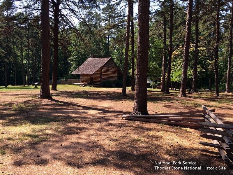
Quaker John Allen constructed this log dwelling circa 1780 in nearby Snow Camp. The State of North Carolina moved it here in 1966, restored it, and opened it to the public in 1967 to illustrate colonial life in the backcountry of North Carolina. The . . . — — Map (db m42253) HM
Colonial trading route, dating from 17th century, from Petersburg, Virginia, to Catawba and Waxhaw Indians in Carolina, passed nearby. — — Map (db m222808) HM
Before and after the Battle of Alamance, the Militia of the Governor William Tryon camped nearby, along Alamance Creek. May 13-19, 1771. — — Map (db m222810) HM
This site and "meeting house" was the area birthplace of a new country in pre-revolutionary meetings, a new county (Alamance), a new county seat (Graham), an early public library, a courthouse, a school to college presidents and a governor, and a . . . — — Map (db m64237) HM
Side A Providence was a gathering spot for pioneers in the Haw River basin. Many families and denominations during the eighteenth century used this cemetery. Many early settlers including members of the Turrentine, Sellars, Holt, Harden, . . . — — Map (db m28277) HM
Colonial trading route, dating from 17th century, from Petersburg, Virginia, to the Catawba and Waxhaw Indians in Carolina, passed nearby. — — Map (db m223046) HM
Saxapahaw was first settled by the Sissapahaw Indians - a hunting and farming tribe. In 1701, explorer and surveyor John Lawson visited the area and described it as "the flower of the Carolinas". In the mid-1700s, the first European settlers came . . . — — Map (db m215840) HM
Original frontier log dwelling built by Quaker John Allen III. House stood approximately 400 feet southeast. Housed five generations. Moved in 1965 to Alamance Battleground State Historic Site. — — Map (db m30287) HM
Settled by Quakers in 1749. Cornwallis camped in area after Battle of Guilford Courthouse and used home of Simon Dixon as headquarters. — — Map (db m223102) HM
In Memory of the Whig and Tory Soldiers who died in the Battle of Lindley's Mill 14th D. 11 Mo. 1781 and were buried here and on the battlefield
Erected 7th Day 10 Mo. 1979 — — Map (db m223104) HM
North Carolina. Colonized, 1585-87, by first English settlers in America; permanently settled c. 1650; first to vote readiness for independence, Apr. 12, 1776
Virginia. First permanent English colony in America, 1607, one of thirteen . . . — — Map (db m95737) HM
Anglican minister to N.C., 1753-71. Served parish of St. Thomas & as chaplain to Gov. Arthur Dobbs. Erected first glebe house on record in the colony. — — Map (db m65664) HM
Bath, originally the Indian town of
Pampticough, was settled by white men
about 1690 and incorporated in 1705.
It is the oldest town in North Carolina.
Its first commissioners were John Lawson,
Joel Martin, and Simon Alderson. Here was . . . — — Map (db m64799) HM
Colonial home of Colonel Robert Palmer, Surveyor-General of North Carolina 1753-1771 and Collector of Customs for the Port of Bath. Built c. 1744, probably by Michael Coutanche, it is one of the oldest surviving dwelling-houses in the State. . . . — — Map (db m66701) HM
1704-John Lawson surveyed 1st 71 lots in Bath.
1710-Thomas Harding, first recorded shipbuilder in Colony, contracted by Gov. Thomas Cary, to build sloop in Pamlico area.
1715-Harding named Town Commissioner & Vestryman. He owned Lots 27-28 at . . . — — Map (db m226318) HM
(side 1)
This cemetery is the burial ground for the Episcopal congregation of Trinity Church Chocowinity.
The Rev. Nathaniel Blount of Chocowinity, a missionary of the Society for the Propagation of the Gospel, established Trinity . . . — — Map (db m226573) HM
The Original Washington
The history of Washington began around 1585 when English explorers first visited the area that would become Washington. The easily navigable waters and excess of natural resources made the area a very successful port . . . — — Map (db m226611) HM
Along the banks of the Chowan River and Salmon Creek, the seeds were planted for the colony and state of North Carolina. From these roots in the 1600s emerged the refined plantation life of the ruling colonial gentry in the 1700s, made possible by . . . — — Map (db m56927) HM
William Gray in 1776 set aside 100 acres at Gray’s Landing for establishing a town. 18th century travelers would have disembarked from sailing vessels docked at the foot of King Street at the old Gray’s Landing site. Visitors to Windsor today, . . . — — Map (db m60629) HM
Created by an act of Colonial Assembly in 1768, New Windsor was established on the site known as Gray’s Landing. A part of grants to the Lords Proprietors, 2800 acres on the Cashie River were sold in 1717 by John Lord Carteret, Earl of Granville to . . . — — Map (db m60630) HM
One and one-half miles northeast stands Oakland, the home
of General Thomas Brown, an officer of the Revolution, 1747-1814. Staunch patriot, statesman, planter. — — Map (db m215474) HM
Commissioners met here to run boundary in 1764. Popular stop for colonial travelers. Ruins used to establish present state line in 1928. Located 2¾ mi. S.E. — — Map (db m5375) HM
South Carolina. Formed in 1712 from part of Carolina, which was chartered in 1663, it was first settled by the English in 1670. One of the 13 original states.
North Carolina. Colonized, 1585-87, b first English settlers in America; . . . — — Map (db m39649) HM
Founded c. 1725, long a principal port of N.C., site of Spanish attack, 1748, and of Stamp Act resistance, 1766. Later abandoned. Was 2 mi. S.E. — — Map (db m6451) HM
A Spanish expedition captured the town of Brunswick, 1748, during King George’s War, but was soon driven away by the colonial militia. — — Map (db m6420) HM
This tablet was erected May, 1911 by the North Carolina Society of Colonial Dames of America to mark the site of Fort Johnston, the first fort in the Province of North Carolina, built under Act of Assembly of 1745 and completed 1764, and named in . . . — — Map (db m4754) HM
Last royal governor of North Carolina, 1771–75. Fearing capture, in June 1775 he sought refuge here. Fled offshore to HMS Cruizer in July. — — Map (db m4790) HM
Barbadian planter turned pirate made North Carolina his base, 1718. Captured in naval battle few miles east. Hanged in Charleston. — — Map (db m101979) HM
Brunswick Town State Historic Site was established on land donated to the State of North Carolina in December, 1952, by James Laurence Sprunt and his four sons, James Laurence Sprunt, Jr., Kenneth Murchison Sprunt, Samuel Nash Sprunt, and Laurence . . . — — Map (db m5535) HM
A memorial to Colonel Maurice Moore, gentleman and soldier of the King, who in the year of our lord 1725 founded in a wilderness The Town of Brunswick reserving for the glory of God the tract of land on which was built this parish church . . . — — Map (db m6510) HM
Ordained 1707; came to America 1708. Served in many churches in area as missionary of Society for the Propagation of the Gospel, 1732–1755. — — Map (db m6483) HM
House built c. 1725, subsequent additions. Home first of Roger Moore, later of Gov. Benjamin Smith, still later of James Sprunt. ¾ mi. E. — — Map (db m167688) HM
Anglican, built under act of 1751. Graves of Governors Arthur Dobbs and Benjamin Smith and U.S. Justice Alfred Moore. Ruins 2 mi. S.E. — — Map (db m6467) HM
Dedicated to the memory of
Samuel Ashe
1725 - 1813
Distinguished North Carolinian
Governor, Statesman and Jurist
in whose honor
the City of Asheville was named
— — Map (db m30120) HM
Organized about 1751
Cabarrus County
formerly Mecklenburg
Alexander Craighead called as regular pastor April 1758, he instilled principles of civil and religious liberty in the people he served and in 1771-1775 they announced to the world . . . — — Map (db m237988) HM
Lutheran. Began ca. 1745 as Dutch Buffalo Creek Church. Adolph Nussman was first regular pastor, 1773. Building erected 1845. 300 yards north. — — Map (db m77369) HM
Colonial trading route started in 17th century; extended from southern Va. to land of Catawba & Waxhaw Indians in N.C. Passed near this spot. — — Map (db m175745) HM
Home of William Lenoir, leader in Revolution & public affairs. Built 1788-92 and named for colonial fort on the site 4½ miles east. — — Map (db m77550) HM
Member of provincial congresses, 1775–1776; lieutenant colonel of militia in Revolution; Congressman, 1795–99. Grave is 7 miles S.E. — — Map (db m2768) HM
Member provincial congress, 1775; brigadier general of militia in Revolution; member N.C. conventions, 1788-1789. Home is 4 miles S.E. — — Map (db m165197) HM
Member provincial congress, 1775; brigadier general of militia in Revolution; member N.C. conventions, 1788-1789. Home was 4 mi. S.E. — — Map (db m165199) HM
Methodist since 1792. Begun as Anglican c. 1733. Visited by bishops Francis Asbury and Thomas Coke. Building erected 1837; remodeled 1882. 2½ mi. E. — — Map (db m56764) HM
Beaufort, North Carolina, was involved in the Trans-Atlantic human trade and is a documented Middle Passage arrival site.
Enslaved people disembarked at or neat this exact location, now called Topsail Park. Records from 1769 show that one . . . — — Map (db m226078) HM
Shackleford Banks is one of the few places on the Eastern United States where you can view wild horses. The horses have Spanish ancestry and their origins likely date from colonial times. These charismatic animals display behaviors which are . . . — — Map (db m226113) HM
Believe it or not, Portsmouth, the small, now-deserted village on this remote island, was once a bustling seaport. North Carolina's colonial legislature chartered Portsmouth in 1733 to serve coastal trade, and for more than two years it was one of . . . — — Map (db m177229) HM
The Middle Passage, part of a larger trade route known as the Triangular Trade, is the route which was used in the trafficking of captive Africans across the Atlantic Ocean to the Americas.
From the 16th to the 19th centuries, approximately 12 . . . — — Map (db m241337) HM
Presbyterian. Began as "Hart's Chapel," about 1765. Mother of many churches. The present building erected 1944, stands 3/4 mile south. — — Map (db m216377) HM
Presbyterian. Founded about middle of 18th century. Hugh McAden, its noted pastor, was buried in the churchyard, 1781. One mile S. — — Map (db m216379) HM
Established 1775 by John Avent (ca.1740-1821). Vital to commerce and travelers crossing the Cape Fear River from Colonial times until 1926 when first bridge was built. — — Map (db m214360) HM
North Carolina. Colonized, 1585-87, by first English settlers in America; permanently settled c. 1650; first to vote readiness for independence, Apr. 12, 1776.
Georgia. The colony of Georgia was chartered in 1732, named for King George . . . — — Map (db m25333) HM
The path now known as the Unicoi Turnpike Trail has existed for over 1,000 years. The earliest European maps of the area note the trail as a connector between Cherokee Territories and the coastal ports at Charleston and Savannah. In 1756, British . . . — — Map (db m120338) HM
The Chowan County Courthouse was erected in 1767, replacing an earlier wooden structure as the seat of government. The structure is considered the finest Georgian-style courthouse in the United States and features a Flemish bond brick exterior, . . . — — Map (db m224374) HM
Home of Thomas Barker, N.C. agent to England, and his wife Penelope, reputed leader of the Edenton "Tea Party," 1774.
Stands 3 blocks south. — — Map (db m34810) HM
Methods of Punishment Punishment in the colonial era focused on public humiliation by forcing the guilty party to spend time in the stocks or pillory. The stocks restrained the feet and the pillory secured the head and hands, . . . — — Map (db m224461) HM
Granite Monument erected September 17, 2017, Honors
Hugh Williamson, son of Scotch-Irish parents, was born 1735. in Nottingham, Pennsylvania. His parents wanted him to become a Presbyterian minister, but his quest for knowledge took him in . . . — — Map (db m225261) HM
Fifty-one women met at Mrs. Elizabeth King's home, which stood 1100 ft. S.E., and resolved, Oct. 25, 1774, to support the American Cause. — — Map (db m34850) HM
Women in this town led by Penelope Barker in 1774 resolved to boycott British imports. Early and influential activism by women. — — Map (db m225212) HM
Sculpted in 1905 by Frank Baldwin, Foundryman This Tea Pot memorializes an inspiring story that tells of patriotism and bravery. See (1864) below for another, little known, but unforgettable saga of Edenton that is an amazing twist . . . — — Map (db m224500) HM
Colonial statesman and Brigadier General of the Edenton District militia. Member, N.C. Committee of Correspondence, 1768, 1773-74. Lived 2 mi. SW. — — Map (db m226505) HM
The road from New England to Charleston, over which mail was first carried regularly in North Carolina, 1738-39, passed near this spot. — — Map (db m79793) HM
435 entries matched your criteria. The first 100 are listed above. Next 100 ⊳