On South Main Street (Maryland Route 808) north of Park Avenue, on the right when traveling north.
The Condon Building was originally built in 1910 for John Condon's Confectionaries & Tea Room. Later it became Mrs. Henley's Tea Room.
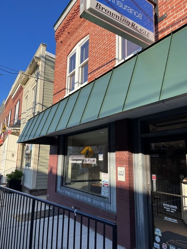
The building was modernized in the late 1940s and became Browning's Grocery. Later it became the home of . . . — — Map (db m199416) HM
On South Main Street (Maryland Route 808) just north of Center Street, on the right when traveling north.
This building was originally constructed in 1957 on land owned by the B&O Railroad. It was built by Ira Watkins as the Lynn Shop, which sold ladies and children's clothes. Since then, this building has been home to:
On South Main Street (Route 808) just south of Center Street, on the right when traveling north.
The building in which the Gun Shack is now located was built in 1912 as the Mount Airy Post Office (shown on the left). The 3rd Floor of this building was the second site of the Mount Airy Telephone Exchange. The building has been the home to . . . — — Map (db m199417) HM
On South Main Street (Maryland Route 808) just south of Center Street, on the left when traveling north.
On this site there once stood the Adam Ruland Bakery, and to the right of it a private residence known as the Linthicum House. Both are shown above. The great fire of 1903 reportedly started in the flue of the store to the south of the bakery and . . . — — Map (db m199397) HM
On South Main Street (Maryland Route 808) north of Center Street, on the right when traveling south.
The William Hood Building is the only structure in Mount Airy to escape destruction by fire over the years. It has been the home to several businesses including:
• Selmann and Hood General Merchandise Store
• Hood's Dry Goods . . . — — Map (db m199367) HM
Near Strawbridge Lane, 0.2 miles west of Wilt Road, on the left when traveling west.
This area was used for cooking meals in the summertime in order to reduce heat in the house as well as doing the laundry, canning food for the winter and storing canned and dry food. — — Map (db m188480) HM
Like it's neighbors this house is 3 story, 3 bay frame dwelling with a rear wing. Standing on a stone foundation, it is covered with weather-boards. Dr. William C. Karsner built this home c. 1884.
He served the people of . . . — — Map (db m33574) HM
On George Street at Fourth Street, on the right when traveling north on George Street.
This home was occupied by several notable people over the years. The bridge tender for the long bridge, Mr. Hevelow, used the railing from the bridge to fence in the yard. Capt. Ed Sheridan operated the ferry which would transverse the canal, until . . . — — Map (db m145125) HM
On George Street, on the left when traveling north.
This building has been greatly altered since it was constructed. It maintains the continuity of the closely-built dwellings along George Street. This is another of the houses built by Thomas Conrey using the products of his mill on the causeway. . . . — — Map (db m145127) HM
The building is considered to be the oldest building in Chesapeake City. Charles and Sarah Beaston purchased Bayard House in 1809 and opened as a tavern and inn in 1829. The tavern was run by Firman Layman until his death in 1881. In 1911, it was . . . — — Map (db m144510) HM
On Bohemia Avenue, on the right when traveling north.
Architecturally the Whiteoak House is representative of vernacular buildings constructed in Chesapeake City in the 1840's and 50's. Old timers in Chesapeake City claim this house rests on the 1st lot sold in town. In 1854, Richard Bayard leased the . . . — — Map (db m144831) HM
On S. Main Street (Maryland Route 222), on the right when traveling north.
Directly across the street stood Washington Hall. The Institute's first building erected 1894 by Jacob Tome (1810-1898) founder and benefactor of The Tome School — — Map (db m147383) HM
On Strauss Avenue at Milburn Place on Strauss Avenue.
This is the site of Saint Charles Roman Catholic Church. The parish began as a “Station Chapel” in the nearby home of the Charles Pye Family. Priests from St. Thomas Manor House in Port Tobacco came by on horseback to minister to the people. Saint . . . — — Map (db m6738) HM
On Hawthorne Road (Maryland Route 225) 0.4 miles east of Chicamuxen Road (Maryland Route 224), on the right when traveling east.
The widow Eilbeck, mentioned in Washington’s diary, lived here. Her daughter, Ann Eilbeck, married Col. George Mason of Gunston Hall, Virginia. Araby built about 1700. — — Map (db m128784) HM
Near North Campus Drive west of Cross Campus Drive, on the left when traveling south.
The structure known as Friendship House was rescued in 1968 from the Nanjemoy Creek site by members of the Historical Society of Charles County.
[Captions:]
Disassembly of the house was meticulous, with each piece of . . . — — Map (db m131658) HM
This property
Has been placed on the
National Register
Of Historic Places
By the United States
Department of the Interior
c. 1847 — — Map (db m114669) HM
On Smith Street, 0.1 miles east of Crusader Road, on the left when traveling east.
Charles Goldsborough, governor of Maryland in 1818, lived in a manor house across Shoal Creek. The house was demolished in the early 1970s and this rare brick stable building is all that remains of the plantation. It was moved here in 1987 and . . . — — Map (db m138287) HM
On Race Street north of Muir Street, on the right when traveling north.
On January 15, 2008 a major fire gutted this 1925 building and destroyed two antiques businesses. The historic structure was about to be demolished when community members rallied to save this facade so that it could remain a part of our streetscape . . . — — Map (db m205063) HM
On Greenway Drive, 0.1 miles east of Abacco Lane, on the right when traveling east.
The David and Polly Robbins Heritage Center, opened in 2007, features exhibits on Native Americans, hunting and trapping, local Dorchester County industry, including both canning and seafood. The workshop of Ron Rue, a local and internationally . . . — — Map (db m138291) HM
On High Street just south of Locust Street, on the right when traveling south.
• Come in and explore the history of wooden boatbuilding in Dorchester County and the Chesapeake Bay.
• Meet Captain James B. ("Mr. James") Richardson and the other innovative builders who created the wooden vessels that shaped the local . . . — — Map (db m138283) HM
On Hudson Road (Maryland Route 343) east of Castle Haven Road, on the right when traveling east.
This colonial tenant house was built on the Spocott Farm around 1800 and was used by the Radcliffe family and those who worked for them.
Much more than an employee
This home's most well known residents were Columbus and Adaline . . . — — Map (db m205111) HM
On Old Madison Road, on the right when traveling east.
Founded 1840 at “Tobacco Stick” Gethsemane was first pastored by Dr. E.F. Ewell in a country Schoolhouse, then in a converted barn. The final building was purchased in 1860, rebuilt in 1892 and razed in 1986. — — Map (db m114977) HM
This building was constructed sometime between 1707 and 1720 as a Chapel of Ease for members of Dorchester Parish who lived too far away from their parish church; Old Trinity Episcopal Church in Church Creek, MD, to conveniently attend services. . . . — — Map (db m114987) HM
Built in 1873 a cost of $3,500, Grace Episcopal Church was constructed as a replacement for the Chapel of Ease, now located next door to the Church, and was a part of the Dorchester Parish of the Episcopal Church. Its parent church was Old Trinity . . . — — Map (db m114986) HM
On Buckeystown Pike (State Highway 85) at Manor Woods Road, on the right when traveling south on Buckeystown Pike.
This street scene photo taken on the bridge crossing Rocky Fountain Creek around 1870, clearly shows the three white tannery buildings on the east side of Buckeystown Pike. The tanning of animal hides was the town's earliest industry. The red brick . . . — — Map (db m19385) HM
On Gapland Road at Arnoldstown Road, on the right when traveling west on Gapland Road.
None of the structures you see here in Crampton’s Gap existed during the battle on September 14, 1862. George Alfred Townsend constructed all the stone buildings and walls, as well as the Correspondents’ Arch, between 1884 and 1896. Townsend, . . . — — Map (db m1931) HM
On Gapland Road just east of Catholic Church Road, on the right when traveling west.
The house served as Union Gen. William B. Franklin's 6th Corps Headquarters on the afternoon of September 14th, 1862 during the Battle of Crampton's Gap. Owned by the Burkittsville Preservation Association, Inc. a 501c3 non-profit, 2 West . . . — — Map (db m173630) HM
Near Urbana Pike (State Highway 355), on the right when traveling north. Reported permanently removed.
James H. Gambrill prospered as a miller after the Civil War, and the family moved up in the world - from a modest dwelling on the lowlands near the mill to this 17-room house on the hill. The three-story frame structure, built about 1872, has . . . — — Map (db m194067) HM
The limestone barracks in front of you, built in 1778, is among the oldest and most important surviving American military structures in the nation. The barracks consisted of two L-shaped buildings, but only the eastern wing remains today. During the . . . — — Map (db m103369) HM
Sir Winston Churchill visited the Barbara Fritchie House while en route with Franklin D. Roosevelt from "Shangri-la" to Washington, D.C. — — Map (db m78351) HM
“We are conscious that it is a considerable undertaking to assume the task of editing a daily newspaper. The duties of the position are rather laborious, requiring constant attention: yet we have fully calculated the chances of success and are . . . — — Map (db m107233) HM
On West Church Street at Record Street, on the right when traveling east on West Church Street.
112 West Church St. Has been placed on the National Register Of Historic Places by the United States Department of the Interior 1814 — — Map (db m2724) HM
On West Main Street / Old National Pike (Alternate U.S. 40) at Garage Drive, on the right when traveling west on West Main Street / Old National Pike.
"Lot No. 1" on Jesserong's plat of Middletown as he laid it out in the year 1767. The Lutheran Parsonage and the two story "Lecture Hall Building" which was located to the front right of the parsonage and the little brick "Pastors Study" located . . . — — Map (db m5301) HM
On West Main Street / Old National Pike (Alternate U.S. 40) at Willow Street, on the right when traveling west on West Main Street / Old National Pike.
This house (ca. 1830) was the birthplace of Thomas C. Harbaugh (1849-1924); One of the most popular American writers of the late 19th and early 20th centuries. His family moved to Ohio when he was 2 years old. Harbaugh wrote thousands of "Dime . . . — — Map (db m5302) HM
On West Main Street / Old National Road (Alternate U.S. 40), on the right when traveling west.
The first building on this corner was a two story, frame dwelling, built in the early 1800s. The property was purchased by the Middletown Savings Bank in 1907, and the house was soon moved to the rear of the lot. The current building was built in . . . — — Map (db m1870) HM
On West Main Street / Old National Road (Alternate U.S. 40) at Church Street (State Highway 17), on the right when traveling east on West Main Street / Old National Road.
The dwelling located here at #8 West Main Street is significant as an early 19th century vernacular log building that was modified in the ca. 1930's with the application of a simulated Flemish bond brick veneer facade. It reflects the development of . . . — — Map (db m5299) HM
On West Main Street / Old National Pike (Alternate U.S. 40) at Church Street, on the right when traveling east on West Main Street / Old National Pike.
Presumably built by Philip Clovinger, 10 West Main began as a one-story log dwelling constructed in the early 1800's. In 1821 Thomas Powell, described as Middletown's first blacksmith, acquired the property and improved the building for commercial . . . — — Map (db m5300) HM
On West Main Street / Old National Pike (Alternate U.S. 40) at Church Street (State Highway 17), on the right when traveling east on West Main Street / Old National Pike.
Given its location, the Coblentz-Long Building has associations with the growth and development of the National Pike and with the Civil War. In 1768 Conrad Crone platted the lots of the entire block 2-14 West Main, known as Smithfield, which were . . . — — Map (db m5297) HM
Built in 1888, this Queen Anne building was constructed to house the Valley Saving Bank (VSB) until 1923, and then served as a U.S. Post Office until the 1960s. When the Post Office relocated, the building began functioning as a private residence. . . . — — Map (db m107653) HM
On East Main Street / Old National Road (Alternate U.S. 40), on the left when traveling west.
This is the entrance to the 133.45 acre John Routzahn farm, established in 1866, known as Woodmere and located on the north and south sides of the Old National Pike. The brick manor house at 400 East Main Street was the original farm house built by . . . — — Map (db m5311) HM
On Alley 5 at East Main Street (Maryland Route 77), on the left when traveling north on Alley 5.
1. The Central Trust Company Bank —
The Central Trust Company was an impressive Greco-Roman building on the corner of Church and West Main Streets on the square. MAny local residents lost their life's savings when the bank met its demise . . . — — Map (db m131819) HM
Near Catoctin Furnace Road (Maryland Route 806) south of Red Bird Lane, on the right when traveling south.
The ruins before you are the remains of a mansion, built ca. 1785 and known for centuries as the Ironmaster's Mansion or Catoctin Manor. The enormous house was surrounded by out-buildings, including quarters for the enslaved domestic servants and a . . . — — Map (db m184329) HM
Near Catoctin Furnace Road (Maryland Route 806) south of Red Bird Lane. Reported permanently removed.
The ruins of the Catoctin Manor are a symbol of the wealth and aristocracy originating from early industrial America. Brothers James and Thomas Johnson established Catoctin Furnace in 1774, which was highly successful in producing pig iron. Thomas . . . — — Map (db m184255) HM
Near Catoctin Furnace Road (Maryland Route 806) south of Red Bird Lane, on the right when traveling south.
(Climbing among the ruins is dangerous, damages your historic resources and it prohibited.)
One a magnificent house, the ironmaster’s mansion was an imposing structure that gave the furnace manager an overview of the furnace complex. The . . . — — Map (db m184250) HM
On Old National Pike (Alternate U.S. 40) east of Washington Monument Road, on the right when traveling west.
As early as 1750, Robert Turner bought land here on the top of South Mountain. The date of construction is unknown, but by 1790 a full-fledged inn was in operation at “Turner’s Gap.” Since then, the building has been in almost continuous use as . . . — — Map (db m243581) HM
On Casselman Road, 0.1 miles north of National Road (Alternate U.S. 40).
Built in 1776 on the road between Salisbury and Pocahontas, Pa. by Solomon Glotfelty, as part of a larger log structure. Moved to Penn Alps in 1972 to be used as an artisan's studio. — — Map (db m137543) HM
On National Pike (Alternate U.S. 40) west of North Old Shade Hollow Road, on the right when traveling west.
This humble log cabin is a rare survivor of a common dwelling built by early settlers on the Allegheny frontier. Built after 1813 as a two-story log building, its large size has led some to believe it was once used as a tavern, giving respite to . . . — — Map (db m243583) HM
On South 1st Street at Alley 3 at the Town Parking Lot on South 1st Street.
The domed building on the hill to your right is the Garrett County Courthouse. Built in 1907 in a classical Greek style and designed by Architect J. Riley Gordon, this is the second building in Oakland to be called the Garrett County Courthouse. The . . . — — Map (db m487) HM
Near West Bel Air Avenue (Maryland Route 132) west of Baker Street, on the left when traveling west.
[Top plaque:]
1896
Baker House
[Center plaque:]
This property has been
placed on the
National Register
of Historic Places
by the United States
Department of the Interior
[Lower plaque:] . . . — — Map (db m138215) HM
On West Broadway west of Richardson Street, on the right when traveling west.
The Liriodendron mansion was built in 1898 as a summer home away from the heat of the Kellys’ Mount Vernon home. The mansion was named after the tulip poplar trees that shade the 200-acre grounds. The Kelly family lived in the mansion until the . . . — — Map (db m173896) HM
The slate-roofed stone building at the bottom of the hill is a springhouse. It was built in the early 19th century to protect a source of drinking water for the people living in the house on the hill. Archer Hays had the house built in 1808, and the . . . — — Map (db m177536) HM
Solid wooden beams frame and support the slate roof
The windows with louvered covers allow fresh air to circulate
Sturdy shelf for items that need not be kept as cold
Thick stone walls built into side of the hill protect the water source . . . — — Map (db m177537) HM
Concord Point, like all lighthouses, was run by the United States
Lighthouse Establishment (LHE). All building projects were
approved and paid for by the LHE.
Several outbuildings were added to the Keeper's House property
including a well in . . . — — Map (db m164220) HM
Several outbuildings were added to the property after the initial construction of the Keeper’s House.
A well was dug in 1827 and research indicated that a pump was installed to draw water.
The pump house was added over the well in 1851. This . . . — — Map (db m165843) HM
On Lafayette Street, on the right when traveling west.
Prior to the building of the Conowingo Dam in 1928, this area
flooded every spring when the snow melted. Light keepers used
a boat to go from the house to the lighthouse in order to light the lamps.
Raised wooden walkways were constructed . . . — — Map (db m164989) HM
This area has always been susceptible to flooding. Several times throughout the year, the entire property would have been under water. There are reports of light keepers taking a boat from the house to the lighthouse in order to light the . . . — — Map (db m165844) HM
On Concord Street, 0.1 miles north of Lafayette Street, on the right when traveling south.
Havre de Grace resident John Donahoo constructed the
lighthouse Keeper's House with attached kitchen, as well as
the lighthouse in 1827. It was originally a one and half story
structure measuring 34 by 20 feet with two rooms and an
attached . . . — — Map (db m164975) HM
Canvasback ducks float quietly on the water The hunter waits Flocks of ducks appear in the sky, cup their wings and drop down to the waiting canvasbacks The hunter's ploy has worked For it was not real canvasbacks that lured the ducks but well . . . — — Map (db m161524) HM
On Lafayette Street close to Concord Street, on the right when traveling west.
In 1920, the Keeper's House and property were sold by the U.S. Government.
The light had been automated and a keeper was no longer necessary.
The building became a boarding house until the mid-1930s. It then
became a bar, dance hall and . . . — — Map (db m164986) HM
On Commerce Street at Market Street, on the right when traveling east on Commerce Street.
Construction began on the Bayou in 1917. Built with solid 18" thick Harford County fieldstone walls and 14" thick wooden beams, it took four years to complete.
The Bayou Hotel opened for business in 1921. It's stunning facilities included a . . . — — Map (db m152374) HM
On Concord Street at Lafayette Street, on the right on Concord Street.
1827-1920. Constructed by John Donahoo of Havre de Grace; Builder of Twelve Maryland Lighthouses
The house and property were sold by the U.S.
Government in April 1920 as the light had been automated and a resident keeper was no longer . . . — — Map (db m164821) HM
On Conowingo Road (U.S. 1), on the right when traveling east.
Historic Joesting - Gorsuch House is an example of eighteenth and nineteenth century frame dwellings. Originally built in the late 1700s on property in Bel Air, the house was enlarged in the 1800s and was once part of an agricultural homestead that . . . — — Map (db m158877) HM
On Darlington Road (Maryland Route 161) just north of Greenspring Road, on the right when traveling south.
A hexagonal fieldstone structure built ca. 1850 by local stone mason Joshua W. Stevens, the Prospect School served grades one through eight until 1930. Polygonal buildings - more typically octagons - were promoted in the mid 19th century for their . . . — — Map (db m52649) HM
Near Rockburn Path west of Clover Path, on the left when traveling west.
Clover Hill Farm House
A portion of the South Area of the park is to be dedicated to interpreting the historical contributions of founding families of the country. Various historic structures are going to be moved or re-created on site . . . — — Map (db m132967) HM
On Old Columbia Pike, on the left when traveling north.
Day, a master stone mason, purchased this lot from the Ellicotts an built this federal style home, one of the oldest brick structures in the district. Rear and side additions were prior to 1887. Later home to the French’s for many years, then . . . — — Map (db m112257) HM
The 1843 Howard County Courthouse, Located on Court Avenue in the Historic District of Ellicott City, Maryland, was the location for judicial proceedings related to legal cases involving those charged with encouraging enslaved persons to run away. . . . — — Map (db m111703) HM
On Main Street west of Court Avenue, on the right when traveling west.
Built by Jonathan Ellicott, John Day used this building as a store and a home in the 1850s. Dr. Thomas B. Owings moved here after death of his wife and six of his children in the 1868 flood. More recently this building has housed many dentists, . . . — — Map (db m98461) HM
In the 1930’s Charles Miller built a new showroom for his Chevrolet dealership here before relocating to Route 40. In 1968 Stromberg Publishing consolidated its offices, warehouse and printing operation here for its Ellicott City then Howard County . . . — — Map (db m111834) HM
William Ellicott commissioned architect N. G. Starkweather and builder C. Timanus to build this home of rubble stone, stuccoed in old Maryland Gold. In the 1850's. Home to Judge John Snowden Tyson, whose surviving maiden daughter Ida lived here . . . — — Map (db m74280) HM
On Main Street west of Court Avenue, on the right when traveling west.
In 1939 this new brick, two-story fire house was built. Fire Department historian B H Shipley, Jr and bride resided on the 2nd floor for seven years. It was also a trolley terminal. The HoCo Volunteer Fire Dept. operated here until 1997, when the . . . — — Map (db m98462) HM
On Old Columbia Pike (Maryland Route 144) 0.1 miles Main Street.
This row of 19th century utilitarian structures has been the architectural orphan of Ellicott City. Referred to on early maps as barns or sheds, these buildings were built between 1830 and 1870 to serve the livery trade. Because of their relative . . . — — Map (db m8110) HM
On Church Road just north of Main Street, on the right when traveling east.
This building was erected in 1889 as the
town’s first fire department.
It served as a working fire station
from that date until 1923.
Subsequent usage included:
Utilization as a meeting hall for the Mayor and City Council of Ellicott . . . — — Map (db m55388) HM
On Main Street (Maryland Route 144) near Forrest Street, on the right when traveling east.
This building was originally the home and dental office of Doctor Mordecai Gist Sykes. Dr. Sykes was a prominent local businessman who served two terms as Ellicott City’s Mayor (1889-1897). The Building has since housed state and local county . . . — — Map (db m111709) HM
Built for Henry Edgar Wootton, Esquire (1837-1894), this is the oldest of the professional buildings which now comprise Ellicott City’s Lawyers’ Row.
Constructed on a 28’ 4” square native granite foundation, it is located on the solid . . . — — Map (db m111839) HM
On Baltimore Street west of Foundry Street, on the right when traveling east.
This historic
mill home
has been placed on the
National Register
of Historic Places
by the United States
Department of the Interior — — Map (db m128067) HM
Near Old Frederick Road (Maryland Route 99) west of Dorchester Way, on the right when traveling west.
Prior to the introduction of indoor plumbing, the privy was the farm family's toilet. It was built over a 6- to 8-foot deep pit. When the pit was full, the privy was moved to a new location. It would commonly be located a short distance behind . . . — — Map (db m168882) HM
On South Cross Street at High Street, on the right when traveling south on South Cross Street.
Building built in 1883 by Thomas S. Bordley as a two-story men’s haberdashery. Gutted by fire in 1910. Rebuilt in 1911. Owned and operated as a men’s store by Carl and Ruth Bordley 1922-1950. Now rented by the Bordley family. — — Map (db m6157) HM
Near High Street near Cross Street, on the left when traveling south.
On this site stood the courthouse built in 1707 which was burned and repaired in 1720. A new building was erected in 1860 and remodeled in 1937. — — Map (db m3065) HM
The house before you - known as Knock's Folly - has witnessed more than 200 years of history. Henry Knock constructed the original clapboard log portion of the house around 1753. Donaldson Yeates bought the log house in 1770. After his death, his . . . — — Map (db m64354) HM
Near Turners Creek Road, on the right when traveling north.
This house illustrates the almost extinct dwellings of the early 1800's that housed slaves/servants of Maryland's Eastern Shore. Believed to have been built as slave quarters and later as part of the African American community in Chestertown. The . . . — — Map (db m64511) HM