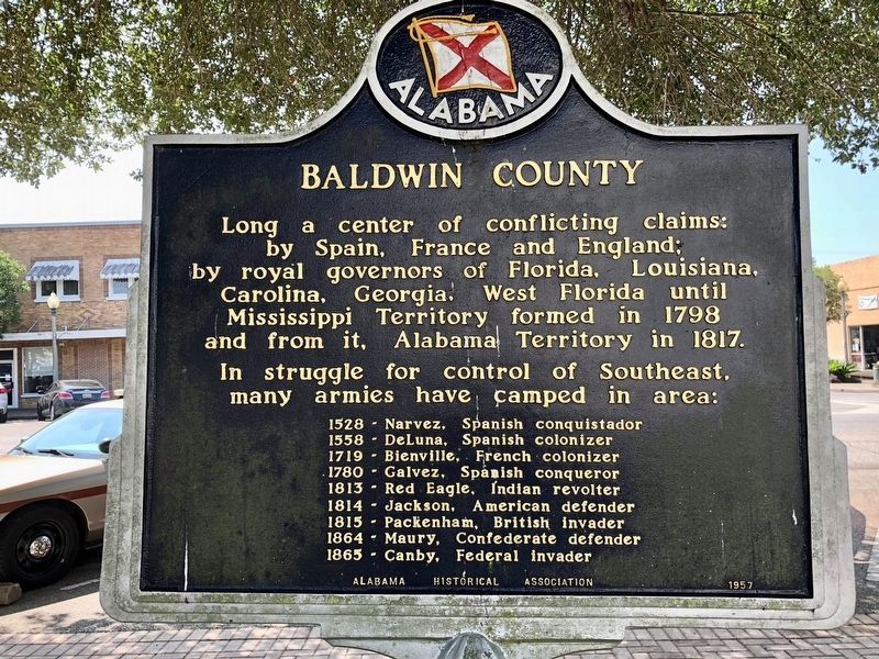
Third oldest county in Alabama.
Created in 1809 while still part
of Mississippi Territory.
Named for Abraham Baldwin (1754-1807)
founder of University of Georgia,
delegate to Constitutional Convention,
member of Congress, 1789-1807. . . . — — Map (db m100839) HM
By the 1750s, French colonists were living on family farms on the shores of Mobile Bay. One group of settlements, known as ‘The Village', was located here along on the bluffs of the eastern shore of the bay. The colonists raised cattle, pigs, and . . . — — Map (db m291606) HM
Near here at junction of Rock Creek and Mobile Bay lies Ecor Rouge, highest coastline point between Maine and Mexico. Aboriginal Indians held powwows and made pottery here. The red cliff, a mariners' landmark on Spanish maps of 1500's, called Ecor . . . — — Map (db m257464) HM
This Shell Banks Baptist Church rests near the location of the first Indian village in America visited by a white man. This was the Indian village of “Achuse” visited by Admiral Maldonado who was one of De Soto’s officers. He scouted the Florida . . . — — Map (db m66295) HM
Old tales have it that early explorers and even pirate vessels obtained potable water from springs scattered throughout the community of Magnolia Springs. This park is located at the largest of dozens of springs in the area.
In 1865 The . . . — — Map (db m68486) HM
The earliest outline of a recognizable bay on the northern coast of the Gulf of Mexico was shown on a 1507 map by German cartographer Martin Waldeseemuller–the same map to first apply the name "America" to the New World.
Alonso Álvarez de . . . — — Map (db m100841) HM
A trail used in early times by Indians, Spanish Explorers, French Settlers and later by soldiers during the battle of Spanish Fort 1865. At one time a stream driven train paralleled this trace. Its ancient road bed can still be seen south of this . . . — — Map (db m100877) HM
Rendezvous for Indians, Spanish, French and English Explorers. In 1865, Three Confederate Brigades, outnumbered 10 to 1, engaged the Army of West Mississippi (Union Forces) in the last battle of the War Between the States. March 26~April 9, 1865. — — Map (db m100844) HM
William Bartram, America's first great naturalist, passed through northwest Butler County in July 1775. He described the "limestone rocks" and "banks of various kinds of sea shells" left by oceans that covered this area millions of years ago, and . . . — — Map (db m120937) HM
The arrival of European explorers and colonists in North
America disrupted the Mississippian world in ways that
researchers are still working to understand. Spanish
explorer Hernando de Soto arrived in the interior in AD
1540. He traveled . . . — — Map (db m144973) HM
This general area is believed to be the site of the Indian village of Costa visited by DeSoto July 2, 1540. The very old cedar trees may have been here at that time. They are some of the largest in the Southeast. These cedars are among the . . . — — Map (db m114988) HM
On January 2, 1944, the State of Alabama granted Hunt Oil Company a permit to drill the A.R. Jackson Well No. 1 at this location near Gilbertown. Hunt Oil Company was owned by the famous oil man, H.L. Hunt of Dallas, Texas. Drilling commenced on . . . — — Map (db m80351) HM
On this site was the "A. R. Jackson Well No. 1". It was
Operated by Hunt Oil Company and was the first
producer in the State of Alabama. This oil well was
completed on February 16, 1944, and produced from
the Selma Chalk formation. It sparked . . . — — Map (db m286132) HM
The forests near Cheaha have been inhabited for thousands of years. Trade
routes brought other native and non-native people to the area searching for
ore, gemstones, venison, hides, furs, honey, beeswax, hickory nut oil, and
other medicinal and . . . — — Map (db m175335) HM
Hernando De Soto in Alabama
Hernando de Soto brought his 700-man army to Alabama in the fall of 1540. This was the first major European expedition to the interior of the southeastern United States. The De Soto expedition had landed at Tampa . . . — — Map (db m114373) HM
Just downstream from Wilson Dam lies a series of trails maintained by the Tennessee Valley Authority. Starting at the Visitor Center, explore the trails as they meander along the riverbank and through the forest
1.Wilson Dam Visitor Center . . . — — Map (db m106186) HM
Waist-high grasses billowing in the
wind. Rolling prairie expanses. Most
people connect these images with the Midwest's Great Plains. But for
thousands of years, tallgrass
soils of Alabama's Black Belt. Along
prairie—25 miles across at its . . . — — Map (db m112692) HM
The Battle of Mabila
The encounter at Mabila between the army of Hernando de Soto and the warriors of Chief Tascalusa ranks as one of the bloodiest Native American battles ever fought in North America. Though the Spaniards emerged . . . — — Map (db m274389) HM
Hernando De Soto brought his 700-man army to Alabama in the fall of 1540. This was the first major European expedition to the interior of the southeastern United States. The De Soto expedition had landed at Tampa Bay, Florida, in the spring of . . . — — Map (db m213362) HM
1492 - Columbus visits Caribbean islands
1519 - Pineda visits Mobile area
1528 - Narváez reaches Mobile area
1540 - De Soto explores Alabama
1559 - De Luna retraces De Soto's route in Alabama
1702 - French establish first . . . — — Map (db m213363) HM
William Bartram, America’s first native born artist-naturalist, passed through Elmore County during the Revolutionary era, making the first scientific notations of its flora, fauna and inhabitants. In 1776 the appointed botanist of Britain’s King . . . — — Map (db m69431) HM
William Bartram, the first native-born American artist-naturalist, of Philadelphia, visited this site on Christmas Day, 1776.
This arboretum commerates (sic) the man, his visit to Fort Toulouse, and his travels through the southeastern . . . — — Map (db m83726) HM
We do not know the exact date that residents of the community of which Omussee Creek Mound was a part abandoned the mound, but by around 1550 it was definitely in decline. Many believe this may have been part of a broader, regional depopulation due . . . — — Map (db m115034) HM
On October 27, 1795, the United States concluded the Treaty of San Lorenzo with Spain, establishing 31 north latitude as the boundary between its southern territory and West Florida. Despite Spanish delays, commissions representing the two . . . — — Map (db m73359) HM
From hosting events in Washington for Mexican diplomats through the Senate Foreign Relations Committee to supporting researchers at McMurdo Station in Antarctica, Celia Heil was the first female of Mexican descent to visit the South Pole. — — Map (db m311523) HM
As an accomplished scientist, Jesse C. James did groundbreaking studies of Venus, Mars, and the Sun; and he managed the Harvard Astronomy Station in Texas. He garnered 12 patents and authored 22 papers in scientific journals.
Inducted 2019
City . . . — — Map (db m219180) HM
Northern Boundary of:
British W. Florida 1764-83
Spanish W. Florida 1783-95
Mississippi Territory: 1798-1804
Washington County 1800-12
Clarke County 1812-15
Southern Boundary of:
British Illinois 1764-83
United States . . . — — Map (db m73532) HM
The Highway Route
The Highway Route of the De Soto Trail is intended to follow the actual trail as closely as major highways permit.
These highways are U.S. 278 from the Georgia line to Piedmont, Ala; Ala. 21 to Winterboro; Ala. 76 to . . . — — Map (db m85384) HM
William Bartram, America's first native born artist - naturalist, passed through Macon County during the Revolutionary era, making the first scientific notations of its flora, fauna and inhabitants. As the appointed botanist of Britain's King George . . . — — Map (db m99676) HM
Neil Armstrong, Apollo 11 commander, spoke his famous words as he stepped onto the surface of the Moon.
On July 20, 1969, President John F. Kennedy's mandate that America go to the Moon was fulfilled - Apollo 11's lunar module Eagle . . . — — Map (db m85465) HM
Of the 355 individuals that flew on NASA's Space Shuttles, 306 were men and 49 were women. Over the course of the program, astronauts from 16 different countries flew Shuttle missions.
Sally Ride became the first American woman in space when . . . — — Map (db m247462) HM
Atlantis was named after the primary research vessel for the Woods Hole Oceanographic Institute in Massachusetts from 1930 to 1966.
Atlantis was the fourth operational Shuttle and made its first flight, STS-51J, on Oct. 3, 1985. This Shuttle sent . . . — — Map (db m247466) HM
Commander Gene Cernan spoke these words as the last man to walk on the Moon.
Apollo 17 was the final Apollo mission and the crowning achievement of the entire Apollo program. The mission set numerous Apollo program records: the longest mission, . . . — — Map (db m85489) HM
Command module pilot Richard Gordon assured Pete Conrad, lunar module commander, that his landing was right on target.
Apollo 12 stands out as the first of the Moon flights to achieve a pinpoint landing. Despite a rocky start caused by . . . — — Map (db m85492) HM
Alabama Astronaut Joe F. Edwards flew the seeds that formed this tree aboard the Space Shuttle Endeavor (OV-105). Launched on January 22, 1998, the seeds traveled with Edwards over 3.6 million miles. After 8 days, 19 hours, and 48 minutes of . . . — — Map (db m247204) HM
Discovery was named after one of the two ships used by the British explorer Captain James Cook when he discovered Hawaii and explored Alaska and northwestern Canada in the 1770s. Discovery was the third operational Shuttle and made its third . . . — — Map (db m247460) HM
The tank exhibited at the U. S. Space & Rocket Center is real. It was delivered to NASA in 1977 it was the first ever built for the shuttle program. The tank was used in the Space Shuttle Main Engine test program at NASA’s Stennis Space Center in . . . — — Map (db m98216) HM
The Space Shuttle, officially called the Space Transportation System (STS) began its flight career on April 12, 1981, with the launch of Columbia from Launch Pad 39A at NASA's Kennedy Space Center in Florida. Atlantis flew the final . . . — — Map (db m247647) HM
Commander Jim Lovell's words initiated heroic efforts by crew and mission control to salvage a crippled spacecraft and return Apollo 13 safely to Earth.
The Apollo 13 mission is the only Apollo flight remembered primarily for the effort to . . . — — Map (db m85543) HM
"…We had to fly once more before we take the big step…" —Apollo spacecraft program manager, George Low, explained why landing on the Moon would have to wait a little longer.
Apollo missions 9 and 10 served as vital dress rehearsals. . . . — — Map (db m85544) HM
Able, an American-born rhesus monkey, and Baker, a South American squirrel monkey, were launched on May 28, 1959, aboard an Army Jupiter missile. Launched in the nose cone, the two animals were carried to a 300-mile altitude, and both were recovered . . . — — Map (db m239330) HM
This vehicle was designed to land two astronauts on the moon and then launch them from its surface. It consisted of two main sections. The lower portion is the Descent Stage, with landing gear, propellant tanks, and a descent engine that could be . . . — — Map (db m247472) HM
The Saturn I was the first American launch vehicle developed solely for space exploration. Taller than a 16-story building, the Saturn I launched 10 tons (9 metric tons) of payload into Earth orbit. First static tested in Huntsville in May of 1961, . . . — — Map (db m247646) HM
Used during the Apollo Lunar Landing Program of the 1960's and 1970's, the Saturn V rocket remains the largest, most powerful rocket ever built.
This full scale mock up was completed in July 1999 to serve as the focal point for the 30th . . . — — Map (db m85601) HM
"…A Merry Christmas and God bless all of you • All of you • On the good Earth."
With these good wishes, the crew of Apollo 8 signed off their Christmas Eve telecast from orbit around the Moon.
These successful flights came only months . . . — — Map (db m85602) HM
Lunar module pilot Jim Irwin described his ride in the first lunar rover.
The Apollo 15 mission is best remembered for introducing the electric Lunar Roving Vehicle, better known as the rover (which was developed at Huntsville's Marshall Space . . . — — Map (db m85603) HM
NASA's Space Shuttles have traveled 542,398,878 miles, making 21,152 Earth orbits. Each vehicle consisted of around 2.5 million moving parts. — — Map (db m247469) HM
Alan Shepard's first words on the Moon - ten years after he made history as the first American in space.
Less than a year after the "successful failure" of Apollo 13, the mission of Apollo 14 accomplished much of what its predecessor had hoped . . . — — Map (db m85605) HM
An Unusual Hybrid
Chief among the many changes made to the Gulfstream G-11 for use as a Shuttle Training Aircraft (STA) is the highly modified cockpit in order to provide the most realistic approach and landing training possible, all the . . . — — Map (db m247645) HM
Development for use for the Space Shuttle, the Space Shuttle Main Engine or RS-25 powered 30 years of spaceflight during 135 missions. The Space Shuttle used three Main Engines, along with two Solid Rocket Boosters, for lift-off. After the solid . . . — — Map (db m247206) HM
Most commonly referred to as the Space Shuttle, the Orbiter was the only part of the Shuttle "Stack" that made the trip into orbit.
Its Solid Rocket Boosters were jettisoned into the Atlantic Ocean, retrieved, and reused. The external tank was the . . . — — Map (db m247467) HM
The Juno II was a modified Jupiter rocket with upper stages and payload sections. Its single engine-just like the Jupiter's-could be gimbaled during launch for steering control. Juno II played an important role in the history of space flight. In . . . — — Map (db m98218) HM
Lunar module pilot, Charlie Duke, exclaimed.
The Apollo 16 astronauts may have qualified for the Guinness Book of World Records for pushing their lunar rover to eleven miles per hour - but that was not their most serious accomplishment. . . . — — Map (db m69754) HM
This plaque was placed here by citizens of Huntsville and Madison County, Alabama in honor of Dr. Wernher von Braun who directed research and development operations for the Army at Redstone Arsenal from 1950 to 1960, and served as Director of . . . — — Map (db m279895) HM
This island, rich in history and legend, was
known to Europeans by 1502. Pineda visited in
1519, Narvaes and deVaca in 1528, the fleet of
deSoto in 1540, and the deLuna colonists in 1559.
In 1699, d'Iberville and Bienville arrived under
orders . . . — — Map (db m226727) HM
Marks 1st Southern Boundary of the United States and the Mississippi Territory created in 1798
-----900 feet East-----
Stone marked 31° North Latitude separating the U.S. & Spanish Florida.
This line of demarcation ran from the . . . — — Map (db m104073) HM
The first and only replica of the Crown & Scepter of Queen Isabella and casks of earth from her place of birth, Madrical, Old Castile, and her place of interment, the Basilica at Granada, reside here, gifts from her beloved Granada. The originals . . . — — Map (db m154246) HM
Adventurer Soldier Dreamer. The first to bring the influence of Spain, its laws, its culture to Alabama. This is an original concept in stone of DeSoto. Vicinte Rodilla Zanón of Valencia • Sculptor 1967 • — — Map (db m154241) HM
“Columbus, I lent you my jewels so you could buy your ships: the only ornaments I have are the violets from the hills.” This statue, a gift from the Spanish Cultural Institute, stood in the Spanish Pavilion at the New York World’s Fair. . . . — — Map (db m154242) HM
Spain came first to our shores in 1519, and her maps gave first to the world knowledge of our lands — Piñeda, De Soto, and then Gálvez. Returning in 1780, she conquered, and wise and benign, ruled for thirty-three years this city, whose . . . — — Map (db m149975) HM
A la gloire de
Pierre Le Moyne D'Iberville,
le heros dela baie d'Hudson,
de Terre-Neuve et de Nevis,
qui fonda en 1702
Mobile
premiere ville de la Louisiane Française.
————
Ne a Montréal en . . . — — Map (db m86490) HM
Spanish conquistador who in the summer of 1559 led a large fleet to the northern Gulf Coast in the earliest grand attempt to colonize the area for Spain. He sailed into Mobile Bay in August 1559 with 11 ships, more than 500 soldiers, 1000 men, . . . — — Map (db m136742) HM
During the Revolutionary War-era, American naturalist
and artist William Bartram journeyed through the
Southeast studying flora, fauna, and indigenous cultures.
His trek through wilderness territory often followed
established Native American . . . — — Map (db m268660) HM
Twelve miles above Montgomery the Coosa and Tallapoosa rivers unite to form the Alabama which meanders over four hundred miles on its way to Mobile Bay. This river has played major role in region's history, being a thoroughfare for Native Americans, . . . — — Map (db m26591) HM
1540 expedition of Spanish explorer Hernando de Soto was first to penetrate Alabama interior. After advancing down Coosa Valley these adventurers camped nearby at Towasa (TO THE WEST) and then followed river on its southern course. In 1702. . . . — — Map (db m224812) HM
Here on May 24, 1703, Alabama Indians ambushed the first French explorers from Mobile, killing three and wounding two critically. The Indians were armed and were used as pawns by British agents from Carolina in the European struggle for dominion . . . — — Map (db m67999) HM
Named in honor of George Noonan Downer, Sr. who rendered exemplary community service for more than 50 years. Gov. John Patterson was dedicatory speaker on Nov. 7, 1961. Mr. Downer was born at Cooksville, Miss., July 31, 1888. Served 30 years as . . . — — Map (db m92648) HM
Archaeology is the scientific study of the past through analysis of physical traces of daily life discovered through excavation. It enables us to extend our knowledge of human history beyond the limits of written records and to learn details about . . . — — Map (db m101816) HM
The town of Coweta was actually two separate Native American settlements and dozens of affiliated outlying communities occupied at different times in what is now northeastern Russell County. "Coweta Tallahassee" (old Coweta), regarded by most . . . — — Map (db m101328) HM
Created in 1818 by territorial legislature. Named for Revolutionary hero, Gen. St. Clair. First settlers from Tennessee, Georgia – veterans of Creek Indian War, 1813-14.
Pell City established as industrial town in 1890 by George H. Pell of . . . — — Map (db m49666) HM
Hernando de Soto brought his 700-man army to Alabama, in the fall of 1540. This was the first major European expedition to the interior of the southeastern United States. The De Soto expedition had landed at Tampa Bay, Florida, in the spring of . . . — — Map (db m294530) HM
1492 — Columbus visits Caribbean islands
1519 — Pineda visits Mobile area
1528 — Narvaez reaches Mobile area
1540 — De Soto explores Alabama
1559 — De Luna retraces De Soto's route in Alabama
1702 — . . . — — Map (db m294532) HM
Northern Boundary of:
British W. Florida 1764-83
Spanish W. Florida 1783-95
Mississippi Territory: 1798-1804
Washington County 1800-12
Clarke County 1812-15
Southern Boundary of:
British Illinois 1764-83
United States . . . — — Map (db m89725) HM
Important Indian town for over 250 years and capital of Coosa province.
Visited by DeSoto in 1540, and later by Spanish, French, British colonial explorers and traders. Early writers tell of abundant food crops, wild and cultivated, . . . — — Map (db m57994) HM
Childersburg traces its heritage to the Coosa Indian village located in the area. DeSoto, accompanied by 600 men, began his march across North America in June 1539. Traveling from Tampa Bay, Florida, northward through what became the Southeastern . . . — — Map (db m45137) HM
1492 - Columbus visits Caribbean islands
1519 - Pineda visits Mobile area
1528 - Narváez reaches Mobile area
1540 - De Soto explores Alabama
1559 - De Luna retraces De Soto’s route in Alabama
1702 - French establish first permanent colony . . . — — Map (db m45496) HM
Created in 1800 by proclamation of
governor of Mississippi Territory.
This was first U.S. civil government
in area that was to become Alabama.
Its original boundaries:
East to west: Chattahoochee to Pearl River;
South, 31° lat. . . . — — Map (db m122343) HM
In 1778, Captain James Cook sailed up "River Turnagain", present day Turnagain Arm. At the time, the Cook Inlet-Susitna River Basins were inhabited by coastal Athabaskan Indians, the Tanainas. The Dena'ina, a sub-group of the Tanaina, lived in . . . — — Map (db m260164) HM
James Cook was born in Yorkshire, England, on October 27, 1728. He was apprenticed to serve on sailing ships built in Whitby, near his birthplace, to carry coal along the English coast. At age 26, he joined the Royal Navy, took part in actions . . . — — Map (db m72493) HM
1776
Two events destined to change the history of the world took place the first week of July 1776.
On the fourth day of July, the Representatives of the United States of America, in general congress assembled at Philadelphia, declared . . . — — Map (db m69767) HM
Miners in 1897 built the Valdez-Eagle Trail. In Klondike Gold Rush, it was used for telegraph lines to Fairbanks. 1910 upgrade, called the Valdez-Fairbanks Wagon Road, under Gen. Wiles P. Richardson, improved for wagon use in the Keystone Canyon . . . — — Map (db m257002) HM
The prospector... knows to an ounce what he needs for a "trip" as he calls an expedition. "Anyone that can't 'pack' ninety pounds would better not come to Alaska," they say, "for this is the least with which he can get along out 'in the . . . — — Map (db m255392) HM
Lieutenant Henry T. Allen led one of America's epic journeys of exploration in 1885. In five months, his expedition crossed 1,500 miles of largely unexplored territory including this valley. The information Allen collected about interior Alaska . . . — — Map (db m255523) HM
The first people of interior Alaska arrived hundreds of generations ago…They moved slowly across the low-lying land known as Beringia, or the Bering Land Bridge.
Jean S. Agner, Professor of Anthropology, University of Alaska, . . . — — Map (db m255394) HM
When the railroad station was built in 1922, on land then outside park boundaries, There was already a tiny settlement here. it came to be known as McKinley Park Station. The entrepreneurs who established it sought to profit from railroad . . . — — Map (db m283499) HM
In 1799, the Russian American Company (RAC) was established via a 20-year renewable charter
granting a monopoly over trading in Russia's North American holdings. The company focused
on exploiting fur resources in Alaska during the first charter . . . — — Map (db m256337) HM
It appears that considerable amusement was furnished by "Wise Mike" Stepovich, whose 2 ½ tons of quartz ore ran through the Citizen's mill this week yielded $700.00. (about 43 oz.)[.] Wise Mike was so jubilant at the richness of the ore that he . . . — — Map (db m257502) HM
Alphonso L'Kievicz was a man well calculated for frontier life, for to him all
things seem easy and nothing to be excited about. He came to Fairbanks in the
early days and brought the first suction dredge here in 1908, which he set up . . . — — Map (db m257540) HM
Felix Pedro changed his name from Felice Pedroni when he immigrated to America and then made his way to Alaska in his mid-30's. Felix discovered gold in the Tanana hills surrounding modern day Fairbanks in July 1902. Felix was E.T. Barnette's . . . — — Map (db m257493) HM
In the early days of our local history, a dog was a revered animal to many men. A good dog could help shoulder a load, provide an ear for a lonely miner, patrol mining camp perimeters and alerting of impending intrusion by either man or beast, . . . — — Map (db m257536) HM
July 20, 1897 · Born in Hatton, North Dakota.
1922-23 · Principal of high school, Fairbanks, Alaska.
February 21, 1924 · Flew first airmail to McGrath.
March 3, 1924 · Honorary Member Pioneers of Alaska.
April 1928 · Flew over top of . . . — — Map (db m255962) HM
From 1905 to 1909, Fairbanks enjoyed several fruitful years of mining as a placer gold camp. However, promising new gold strikes in other parts of Alaska were beginning to pull people and businesses out of Fairbanks. Several key businessmen . . . — — Map (db m257489) HM
4923 entries matched your criteria. The first 100 are listed above. Next 100 ⊳