On Pennsylvania Avenue Northwest at 10th Street Northwest, on the right when traveling east on Pennsylvania Avenue Northwest.
The Federal Bureau of Investigation is headquartered across Pennsylvania Avenue from this spot. Thanks to popular media, it may be one of the better-known government agencies. Since the 1930s Hollywood has found great stories among the . . . — — Map (db m57218) HM
On Pennsylvania Avenue Northwest at 9th Street Northwest, on the right when traveling east on Pennsylvania Avenue Northwest.
The National Archives, keeper of the nation's founding documents and most important federal government records, occupies this important spot halfway between the Capitol and the White House. Before the Archives building was constructed, federal . . . — — Map (db m57217) HM
On Constitution Avenue Northwest (U.S. 1/50) west of 12th Street Northwest, on the right when traveling west.
The U.S. Environmental Protection Agency is the youngest agency housed here in the Federal Triangle. Established as an independent agency in 1970, EPA protects human health and the environment through science, transparency, and the rule of . . . — — Map (db m57211) HM
On 14th Street Northwest south of D Street Northwest, on the right when traveling north.
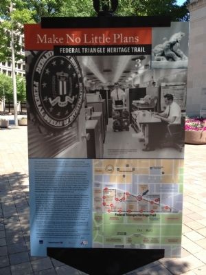
Across the street the Department of Commerce's Herbert C. Hoover Building anchors the Federal Triangle, just as the department - with its mission of promoting trade, supporting economic development, and strengthening the competitiveness of . . . — — Map (db m57204) HM
On Pennsylvania Avenue Northwest just west of 13 1/2 Street Northwest, on the right when traveling east.
The John A. Wilson Building is the headquarters of the local government that serves over 600,000 citizens who call the nation's capital their home. The Mayor and the 13-member Council, elected by the residents of the District of Columbia, . . . — — Map (db m218235) HM
On Pennsylvania Avenue Northwest at 14th Street Northwest, on the right when traveling east on Pennsylvania Avenue Northwest.
This is the John A. Wilson Building, Washington, DC's city hall, home to DC's mayor and city council. When completed in 1908, it was known as the District Building (for District of Columbia). Cope and Stewardson of Philadelphia won the . . . — — Map (db m57141) HM
On Pennsylvania Avenue Northwest just west of 14th Street Northwest, in the median.
When "the Great War" ended in 1918, the United States did not have a tradition of national war memorials. Most memorials honored veterans from the local community, such as the District of Columbia War Memorial on the National Mall. An exception . . . — — Map (db m171292) HM
On F Street Northwest east of 20th Street Northwest, on the right when traveling west.
This large free-standing townhouse was built in 1849, and is one of the few remaining houses with Greek Revival elements in the city. — — Map (db m116985) HM
On 21st Street Northwest north of F Street Northwest, on the left when traveling south.
These two circa 1800 Federal Style houses were built by John Lenthall, architect and principal assistant to Benjamin Latrobe on the construction of the United States Capitol. The houses were originally located at 612 and 614 19th Street, N.W., and . . . — — Map (db m115901) HM
Near G Street Northwest just west of 17th Street Northwest, on the left when traveling west.
The Washington Loan & Trust Company, a predecessor of the Riggs Bank, was established in 1889, at which time it was the first chartered bank in Washington, D.C. In 1923, The Trust built a new, one story stone bank at the corner of 17th & G Streets, . . . — — Map (db m142261) HM
Near G Street Northwest just west of 17th Street Northwest, on the left when traveling west.
Notable architectural features comprised the Washington Loan & Trust Company Building, which originally stood at the corners of 17th and G St Northwest. Decorative elements from the bank building included the four medallions displayed here. Each . . . — — Map (db m142262) HM
Near G Street Northwest just west of 17th Street Northwest, on the left when traveling west.
In 1923, The Washington Loan Trust built a new, one story stone bank at the corner of 17th & G Streets, N.W. but in 1974 the building was razed for the construction of the Federal Home Loan Bank Board building that currently stands at this location. . . . — — Map (db m142263) HM
On H Street Northwest west of 18th Street Northwest, on the left when traveling east.
"I am interested in how interactivity and play help us understand how we relate to one another. I create disarmingly fun experiences allowing people to let down their boundaries and connect. By expressing my ideas through . . . — — Map (db m223817) HM
On 23rd Street Northwest south of H Street Northwest, on the right when traveling south.
Listed in the
National Register of Historic Places, was the first Black Episcopal church built in the City of Washington.
Saint Mary’s represents a landmark in the history of the Black American struggle for equal rights and human dignity, . . . — — Map (db m182173) HM
Near Linnean Avenue Northwest, 0.1 miles south of Upton Street Northwest, on the right when traveling north.
In 1983, Hillwood commissioned architects to create a structure to house part of Marjorie Post's collection of American Indian objects that she had acquired to decorate Camp Topridge, her retreat in Upstate New York, and would later donate to the . . . — — Map (db m178210) HM
Near Linnean Avenue Northwest, 0.1 miles south of Upton Street Northwest, on the right when traveling north.
Marjorie Post built this adaptation of a Russian country house, called an izba or dacha, in 1969. Russian-style carvings surround the doors and windows of the California redwood-clad masonry structure. Other details, such as the bright . . . — — Map (db m178211) HM
Near Linnean Avenue Northwest, 0.1 miles south of Upton Street Northwest, on the right when traveling north.
Fanciful touches lend a whimsical air to this intimate, formal garden inspired by those designed in France in the 1700s. Ivy-covered walls enclose the garden, and beds of closely trimmed boxwood and gravel paths section the space. Sculptures . . . — — Map (db m178216) HM
Near Linnean Avenue Northwest, 0.1 miles south of Upton Street Northwest, on the right when traveling north.
Step down into this secluded garden featuring a miniature mountain landscape. Paths follow the rushing stream as it cascades through rocky terrain to fill a peaceful pond below. The garden showcases a mix of Japanese and American gardening . . . — — Map (db m178212) HM
Near Linnean Avenue Northwest, 0.1 miles south of Upton Street Northwest, on the right when traveling north.
The mansion's portico, or porch, offers a panoramic view across the Lunar Lawn to the Washington Monument in the distance. Marjorie Post hosted garden parties here, welcoming friends, veterans, students, leaders in politics and the arts, and . . . — — Map (db m178214) HM
Near Linnean Avenue Northwest, 0.1 miles south of Upton Street Northwest, on the left when traveling south.
The Georgian-style mansion was built for Washington social figures Helen and Henry Parsons Erwin in 1926. In 1955, Marjorie Post purchased the estate, at the time known as Arbremont, and renamed it Hillwood. From 1955 to 1957, Post renovated and . . . — — Map (db m178204) HM
Near Linnean Avenue Northwest, 0.1 miles south of Upton Street Northwest, on the left when traveling south.
Marjorie Post designed Hillwood with the pleasure of her guests in mind. The diplomats, politicians, students, military veterans, public figures, and family members who arrived at Hillwood's stately gates followed the winding drive to the lushly . . . — — Map (db m178205) HM
Near Linnean Avenue Northwest, 0.1 miles south of Upton Street Northwest, on the right when traveling north.
Climbing roses and wisteria drape the pergola in this garden in spring to provide shade and pleasant fragrances. Beginning in spring and continuing into summer, floribunda roses delight with their brilliant colors. Marjorie Post, who died in 1973, . . . — — Map (db m178217) HM
Near Linnean Avenue Northwest, 0.1 miles south of Upton Street Northwest, on the left when traveling south.
In 1955, Marjorie Post built a home for the head gardener on this house. He supervised a staff of about fifteen that maintained Hillwood's extensive gardens and grounds. The gardener's house was razed in 1996 to make way for the visitor center, the . . . — — Map (db m178206) HM
On Main Drive Northwest, 0.1 miles west of 12th Street Northwest, on the right when traveling east.
While the hospital continued to emphasize clinical microscopy and bacteriology, achievements in other fields set the standards for military and civilian care in fields such as dentistry and X-ray use. The circumstances of World War I and the high . . . — — Map (db m143699) HM
On Main Drive Northwest, 0.1 miles west of 12th Street Northwest, on the right when traveling east.
The home of Thomas Carberry was later sold to James Donald Cameron, former Secretary of War under President Grant. When the U.S. government acquired property here for the Army hospital in 1905, the small stream running through the property was . . . — — Map (db m143703) HM
On Main Drive Northwest, 0.1 miles west of 12th Street Northwest, on the left when traveling west.
As conceived by Major Borden, the Walter Reed General Hospital campus was to focus around a large hospital and administrative building, with separate and symmetrically arranged outbuildings. In 1905, congressional funding provided for construction . . . — — Map (db m143696) HM
Near Main Drive Northwest west of 12th Street Northwest, on the left when traveling west.
To keep pace with the advances in medical technology and consolidate patient care in one facility, congressional funds were procured for a new modern hospital facility on the WRAMC campus in 1967. Construction of the New Hospital commenced in 1972, . . . — — Map (db m143704) HM
On 44th Street Northwest just south of Reservoir Road Northwest, on the left when traveling north.
Welcome to Foxhall Village, one of Washington DC's most charming and distinctive residential neighborhoods. Construction of the English Tudor style homes began in 1925. To protect the architectural integrity of the neighborhood, the community . . . — — Map (db m187487) HM
On 44th Street Northwest at Q Street Northwest, on the right when traveling north on 44th Street Northwest.
After local builder Harry K. Boss visited England in the mid-1920s, he was determined to build a community reflecting the architecture of the town of Tewkesbury and in the spirit of ancient Bath. In 1925, the firm of Boss and Phelps, working with . . . — — Map (db m187490) HM
On 31st Street Northwest north of M Street Northwest, on the left when traveling north.
This building dates to the late 1700's and reputedly was constructed from brick which had been used as ballast in a ship from England. Originally the first apothecary store in Washington, it became a sign shop around 1860. In the 1890's, it was . . . — — Map (db m113645) HM
On O Street Northwest at 31st Street Northwest, on the right when traveling east on O Street Northwest.
Almost a miniature Gothic cathedral, Christ Church behind you was built in 1885. It is the third building to occupy the spot since a group of Georgetown Episcopalians founded the parish in 1817. Among the founders were Francis Scott Key, author of . . . — — Map (db m113421) HM
Near 31st Street Northwest north of Avon Lane Northwest, on the right when traveling south.
The original Box Knot, located on the east side of the Center Walk, fell into disrepair during the Civil War. The garden's design was lost until 1929, when Armistead Peter 3rd "rediscovered" it in the book Historic Gardens of Virginia, . . . — — Map (db m241125) HM
On 31st Street Northwest north of Avon Lane Northwest, on the right when traveling south.
In the early 19th century, the northeast portion of the garden was an orchard with pears, apples, and other fruits. By the 1880s, this area was leveled and converted into a lawn tennis court used by Britannia's grandchildren. They formed the . . . — — Map (db m241127) HM
Near 31st Street Northwest north of Avon Lane Northwest, on the left when traveling north. Reported permanently removed.
In the 1800s, a barn stood to the right of the building you see today. The garage, the left hand portion of the building ahead, was built in 1913-1914 to house the family’s automobile and to provide an apartment for the chauffeur. The last . . . — — Map (db m95957) HM
Near 31st Street Northwest at Avon Lane Northwest, on the right when traveling south.
The Garage was constructed in 1913 by Armistead Peter Jr. It was designed by his brother, Washington architect Walter G. Peter, and featured three automobile bays, second-floor housing for staff, a laundry, and a basement steam boiler to heat . . . — — Map (db m241124) HM
On P Street Northwest at 27th Street Northwest on P Street Northwest.
You are standing in the heart of a once thriving African American community. At the time of the American Revolution in 1776, one third of Georgetown's population was African American. By the time of the Civil War in the 1860s, many former slaves . . . — — Map (db m110018) HM
On K Street Northwest at 30th Street Northwest, on the right when traveling east on K Street Northwest.
Georgetown began in the 1740s as a tobacco port, where ships departed for Britain, Europe and the West Indies filled with flour, lumber, coal, grain and, above all, tobacco. The fine harbor brought visitors and goods and, with them, prosperity . . . — — Map (db m113415) HM
On Prospect Street Northwest at 34th Street Northwest, on the left when traveling west on Prospect Street Northwest. Reported damaged.
The early mansions of wealthy ship owners, merchants and land speculators in this part of Georgetown were built high above the Potomac River with fine views, or prospects, of the harbor filled with ships and the wilds of Virginia on the other . . . — — Map (db m113401) HM
On 30th Street Northwest just south of Dumbarton Street Northwest, on the right when traveling north.
Federal style brick house built for Col. Charles Beatty, prominent leader in the Revolutionary War and owner of ferry between Georgetown and Rosslyn; 1806-22 owned by Nicholas Hedges; also residence of merchant Thomas Hyde and son Anthony Hyde, . . . — — Map (db m248781) HM
Near Q Street Northwest east of 34th Street Northwest.
His half-century of articulate, constructive and untiring activism on behalf of urban planning and historic preservation helped shape the face of Georgetown and the City of Washington.
President and Fellow, Washington Chapter of the AIA
. . . — — Map (db m112136) HM
On Olive Street Northwest west of 27th Street Northwest, on the right when traveling east.
c. 1869 Erected by Edgar Murphy, prominent African-American carpenter.
1948 - 1961 Home of Julia Child, famous chef, author and television personality.
1970 Renovated by Hugh Newell Jacobson, renowned architect. . . . — — Map (db m241118) HM
On M Street Northwest at 30th Street Northwest, on the right when traveling east on M Street Northwest.
M Street has always been heavily traveled. In 1795 this prompted passage of the first local speeding law, making it illegal to gallop horses on M Street. Back in 1634, things were quieter. Then, Englishman Henry Fleet wrote of finding "deer, . . . — — Map (db m97704) HM
On 36th Street Northwest south of P Street Northwest, on the right when traveling north.
In 1821, George MaHorney, a bricklayer, built this two room, two story frame "laborer's cottage." William W. Corcoran, a founder of the Corcoran and Riggs Bank and the Corcoran Gallery of Art, owned the property from 1853, through the Civil War, . . . — — Map (db m112144) HM
On Water Street Northwest west of 33rd Street Northwest, on the right when traveling east.
Potomac Boat Club
Founded in 1869
This Boathouse built in 1908
A.B. Mullet & Co., Architect
Charles J. Cassidy, Builder
Listed in the
District of Columbia Inventory of Historic Sites
1973
National . . . — — Map (db m129836) HM
On 30th Street Northwest north of M Street Northwest, on the right when traveling south.
Foundation for Preservation of Historic Georgetown Easement acquired October, 1975 Accepted, March, 1976, by National Trust for Historic Preservation Additional marker: 1210 30th Street, N.W. Andrew Ross Tenant House II Built by Andrew Ross . . . — — Map (db m97705) HM
Near 31st Street Northwest at Avon Lane Northwest, on the right when traveling south.
One of the primary landscape features of the property is the wide and gently sloping South Lawn which served both ornamental and functional purposes. Influenced by late 18th century English landscape design with informal and naturalistic, rather . . . — — Map (db m241120) HM
On Potomac Street Northwest at O Street Northwest, on the right when traveling east on Potomac Street Northwest.
This first Episcopal congregation in Georgetown was founded in 1796 by the Reverend Walter Dulany Addison. Other founders and benefactors include Thomas Hyde, Thomas Corcoran, Benjamin Stoddert, and Francis Scott Key. President Thomas Jefferson . . . — — Map (db m113951) HM
On N Street Northwest at 30th Street Northwest, on the right when traveling west on N Street Northwest.
Hidden behind the grand houses of N Street — and many others large and small — are tranquil walled gardens with brick terraces, old shade trees, lily ponds, swimming pools, and a tennis court or two.
Behind you stands the Edes Home, . . . — — Map (db m113641) HM
On M Street Northwest west of Wisconsin Avenue Northwest, on the right when traveling east.
First built in 1796 Restored by the City Tavern Association Founded 1959 Founders Mr. Robert Calhoun Baker · Capt. and Mrs. Peter Belin (UNS, Ret.) · Mrs. Denton Blair · Hon. and Mrs. Robert Woods Bliss · Hon. and Mrs. David K. E. Bruce · Mr. and . . . — — Map (db m97686) HM
On 30th Street Northwest just north of N Street Northwest, on the right when traveling north.
The Colonial, a historic building in Georgetown, was occupied from 1826 to 1861 by Miss Lydia English's Georgetown Female Seminary. After the Union Forces' defeat at the First Battle of Bull Run, the building was repurposed as an Army general . . . — — Map (db m248779) HM
On R Street Northwest east of Wisconsin Avenue Northwest, on the right when traveling east.
Occupying the most prominent site on the Georgetown Heights overlooking Georgetown, the Potomac River and Virginia is the Georgetown Branch Library. The library houses the Peabody Room, an archive devoted to the history of Georgetown. The archive . . . — — Map (db m101365) HM
On P Street Northwest west of 31st Street Northwest, on the right when traveling west.
The Presbyterian Congregation in George Town, founded in 1780 and chartered by Congress in 1806, has the longest unbroken ministry in Washington. This building was erected in 1821 at what is now 30th and M, was moved to this site in 1873 and altered . . . — — Map (db m97747) HM
On 35th Street Northwest at Volta Place Northwest, on the left when traveling south on 35th Street Northwest.
Volta Bureau
has been designated a
Registered National
Historical Landmark
under the provisions of the
Historic Sites Act of August 21, 1935
This site possesses exceptional value
in commemorating or illustrating
the . . . — — Map (db m112142) HM
On 4th Street Northwest at Indiana Avenue Northwest, on the right when traveling south on 4th Street Northwest.
The Great Depression (1929-1941) meant economic catastrophe for millions of Americans, but in Washington it meant a building boom as the Federal Government staffed up to the end the economic crisis. In 1931 alone Congress approved new . . . — — Map (db m61823) HM
On Constitution Avenue Northwest (Alternate U.S. 1) west of 4th Street Northwest, on the right when traveling west.
A bronze likeness of Chief Justice John Marshall, visible on your way to the next Heritage Trail sign, keeps watch over John Marshall Park to your right. Marshall is remembered for molding the U.S. Supreme Court into today's authoritative body. . . . — — Map (db m56495) HM
On 4th Street Northwest at Indiana Avenue Northwest, on the left when traveling south on 4th Street Northwest.
Welcome to downtown Washington DC - an area rich in history, culture and places to see. You will enjoy visiting the following sites located in the vicinity of this sign.
Clockwise from top:
"Lone Sailor" at the US Navy . . . — — Map (db m110214) HM
On 20th Street Northwest at Columbia Road Northwest, on the right when traveling north on 20th Street Northwest.
dubbed "best addresses" by historian James Goode, the grand apartments of the Kalorama Triangle are among the city's earliest. The Mendota (1901) located at 2220 20th, is the city's oldest intact luxury apartment house. The Wyoming (1905_1911), . . . — — Map (db m130714) HM
On Connecticut Avenue Northwest north of California Street Northwest, on the right when traveling north.
This building in the historical district of Kalorama houses the Embassy and the Consulate of the Republic of Malta. It was built in 1903 on the plans of the noted American architect Waddy Butler Wood (1869-1944). In 1987 it was listed on the . . . — — Map (db m119777) HM
On Columbia Road Northwest north of Mintwood Place Northwest, on the right when traveling south.
You are standing in the Kalorama Triangle Historic District, listed on the National Register of Historic Places since 1987. Most of its elaborate houses were built between 1888 and 1930 in what was then the "Washington Heights" subdivision. . . . — — Map (db m130715) HM
On Florida Avenue Northwest (U.S. 29) near 6th Street Northwest, on the right when traveling west.
A Peaceful Landscape With City Conveniences for wealthy Washingtonians: that was the goal of the men who made LeDroit Park.
Brothers-in-law Amzi L. Barber and Andrew Langdon purchased land here, and in 1873 hired local architect/builder . . . — — Map (db m152365) HM
Near Logan Circle Northwest at Rhode Island Avenue Northwest, on the right when traveling south. Reported missing.
The Logan Circle Historic District has a rich history of change. A fashionable, exclusive neighborhood had evolved by the 1870s – home to members of Congress, such as Senator John Logan of Illinois. By the turn of the 20th century, Iowa – later . . . — — Map (db m63401) HM
On P Street Northwest at Logan Circle Northwest, on the left when traveling east on P Street Northwest.
Pierre L'Enfant's 1791 design for the Nation's capital featured a prominent triangle formed by the "President's House" and two intersections: Pacific Circle, located to the northwest of the presidential residence, and Iowa Circle, to the northeast. . . . — — Map (db m153986) HM
On Vermont Avenue Northwest south of Q Street Northwest when traveling south.
Some of the City's finest Victorian Houses ring Logan Circle. While the area appears on the L'Enfant Plan of 1791, it took Alexander “Boss” Shephard's improvements to make these grand houses of the 1870s and '80s possible.
Three Union . . . — — Map (db m130851) HM
On Logan Circle Northwest west of 13th Street Northwest, on the right when traveling west.
9 Logan Circle has been designated a
National Historic Landmark
———
The Preservation of the Pratt house conforms to
National Park Service, U.S. Department of Interior standards
and is consistent with the historic . . . — — Map (db m79589) HM
On R Street Northwest just west of 14th Street Northwest, on the right when traveling west.
The Hawarden
1901
has been placed on the
National Register
of Historic Places
by the United States
Department of the Interior
George S. Cooper, Architect — — Map (db m145634) HM
Near Wisconsin Avenue Northwest north of Cathedral Avenue Northwest, on the right when traveling north.
The overall inspiration for the Bishop's Garden is a 14th century monastic garden, in keeping with the gothic design of the Cathedral. However, this small garden room — called the Hortulus or "little garden" — is anchored firmly in the 9th century . . . — — Map (db m203137) HM
Near Wisconsin Avenue Northwest, 0.1 miles north of Cathedral Avenue Northwest, on the right when traveling north. Reported permanently removed.
The August 23, 2011, magnitude 5.8 earthquake left the flying buttresses in bad shape. The shaking cracked buttress flyers, twisted buttresses pinnacles and shook stones apart. To stabilize the stones and prevent major damage in the case of a future . . . — — Map (db m203134) HM
On Wisconsin Avenue Northwest, 0.1 miles north of Cathedral Avenue Northwest, on the right when traveling north. Reported permanently removed.
The massive 50-ton, 40+-foot tall grand pinnacles at the top corners of the central tower sustained some of the worst earthquake damage—cracking, twisting and literally popping the top off one of the pinnacles. The eight smaller intermediate . . . — — Map (db m203127) HM
Near Wisconsin Avenue Northwest, 0.1 miles north of Cathedral Avenue Northwest, on the right when traveling north. Reported permanently removed.
Look up—can you find our decapitated gargoyle? Only the stump of his neck remains after the head was removed for safety reasons.
Only one gargoyle was damaged in the August 23, 2011, magnitude 5.8 earthquake. This gargoyle, known as the . . . — — Map (db m203130) HM
Near Wisconsin Avenue Northwest, 0.1 miles north of Cathedral Avenue Northwest, on the right when traveling north. Reported permanently removed.
Carvings of 16 Old Testament prophets decorate the grand pinnacles of the south transept. The south transept withstood some of the worst damage in the August 23, 2011, magnitude 5.8 earthquake. Since the earthquake, the western grand pinnacle was . . . — — Map (db m203132) HM
Near Wisconsin Avenue Northwest just south of Woodley Road Northwest, on the right when traveling north. Reported permanently removed.
The buttresses that run along the north and south nave generally sustained less damage than the freestanding flying buttresses of the east end, as the lower portions of these buttresses are "engaged" in the lower part of the nave exterior walls. . . . — — Map (db m203141) HM
Near Wisconsin Avenue Northwest just south of Woodley Road Northwest, on the right when traveling north. Reported permanently removed.
The north side did not come through unscathed on August 23, 2011. Like the corresponding grand pinnacles on the south transept, the grand pinnacles of the north transept also cracked and twisted. Several of the delicate spires of the secondary . . . — — Map (db m203142) HM
On Wisconsin Avenue Northwest, 0.1 miles north of Cathedral Avenue Northwest, on the right when traveling north.
The Earthquake
On August 23, 2011, a magnitude 5.8 earthquake shook the East Coast, causing over $34 million in damage to Washington National Cathedral. While the Cathedral withstood the quake largely intact, buttresses cracked, large . . . — — Map (db m203126) HM
Near Wisconsin Avenue Northwest south of Woodley Road Northwest, on the right when traveling north. Reported permanently removed.
Energy from the 2011 earthquake traveled upward, like the energy traveling to the tip of a cracked whip. Most of the worst damage therefore took place at the tops of towers and buttresses. On the west towers the damage was mostly limited to the . . . — — Map (db m203138) HM
Near Wisconsin Avenue Northwest north of Massachusetts Avenue Northwest, on the right when traveling north.
The limestone pinnacles were damaged in the August 23, 2011, earthquake here. The ground shook for less than a minute but caused the 301-foot central tower of Washington National Cathedral to whip back and forth. Some of the 50-ton pinnacles . . . — — Map (db m71202) HM
On Wisconsin Avenue Northwest north of Quebec Street Northwest, on the left when traveling north.
Friendship was the country estate for two generations of the McLean family. The English style manor house “Eden Bower” was built around 1800 by British Col. Richard Pyle. Pyle was succeeded by Georgetown University, which used the . . . — — Map (db m152176) HM
On Woodley Road Northwest at Wisconsin Avenue Northwest, on the left when traveling north on Woodley Road Northwest.
In the late nineteenth century, a rural retreat called the Woodley Inn rose near what became Massachusetts Avenue and 38th Street. Before the advent of air conditioning, wealthy families summered on the heights overlooking the city to escape the . . . — — Map (db m112151) HM
On Kilbourne Place Northwest at 17th Street Northwest, on the right when traveling west on Kilbourne Place Northwest.
Even before the United States entered World War II in 1941, thousands of workers from across the country streamed into Washington to fill new military and government jobs. The swelling population needed more housing, and, to accommodate them, . . . — — Map (db m111891) HM
On Park Road Northwest at 18th Street Northwest, on the right when traveling east on Park Road Northwest.
Around 1900 this successful suburb attracted successful business leaders, who set a grand standard for home building. Printer Byron S. Adams commissioned architect Frederick Pyle to design 1801 Park Road in the Colonial Revival style. Pyle . . . — — Map (db m130876) HM
On Pierce Mill Road Northwest at Park Road Northwest, on the right when traveling north on Pierce Mill Road Northwest.
Like the Latino immigrants of recent times, Europeans left the political and economic hardships of home for a better life in the United States. Following the 1948 communist coup of Czechoslovakia a "Czech Row" or "Prague Road" enclave . . . — — Map (db m152976) HM
On Park Road Northwest just east of 19th Street Northwest, on the right when traveling east.
In 1948 the U.S. Supreme Court ruled that covenants prohibiting the sale of houses to individuals of certain races could not be enforced. Two years later, Dr. Robert Deane became the first African American to purchase a house in Mount . . . — — Map (db m130875) HM
On Mount Pleasant Street Northwest just north of Lamont Street Northwest, on the right when traveling south.
In 1903 a street car line arrived on Mt. Pleasant Street and so did new businesses. In this block were Sophia Weiss's notions shop, Domenico Pappalardo's shoe shop, and Lee Sing's laundry. The block's first commercial building (3215) was . . . — — Map (db m130880) HM
On 16th Street Northwest at Lamont Street Northwest on 16th Street Northwest.
When the Mount Pleasant Library, behind you, opened in 1925, crowds flocked to the Classical style building. Many had campaigned long and hard for this community centerpiece. The Carnegie Corporation, funder of public libraries in Mount Vernon . . . — — Map (db m130864) HM
On Mount Pleasant Street Northwest at Kenyon Street Northwest, on the right when traveling south on Mount Pleasant Street Northwest.
During the second half of the 20th century, housing in Mount Pleasant was relatively affordable. Recent immigrants, students, young professionals, and families from diverse economic backgrounds populated the neighborhood. In 1986, residents . . . — — Map (db m130883) HM
On Newton Street Northwest, 0.1 miles east of 19th Street Northwest, on the left when traveling east.
Ingleside, the grand house to your left, once anchored a 139-acre estate. Thomas Ustick Walter (1804-1887), architect of portions of the U.S. Capitol, designed Ingleside in 1851. Today it is Mount Pleasant's oldest structure.
New York . . . — — Map (db m184985) HM
On Mount Pleasant Street Northwest at Kenyon Street Northwest, on the right when traveling south on Mount Pleasant Street Northwest.
Harry Townsend, who passed away at the age of 102 in 2004, had lived in the 1700 block of Kenyon Street since 1956. He was a well-known local figure who worked in construction. Townsend was still helping neighbors with repairs at age 90. . . . — — Map (db m179596) HM
On Oakwood Terrace Northwest at 17th Street Northwest, on the left when traveling north on Oakwood Terrace Northwest.
This was the western edge of Samuel P. Brown's Mount Pleasant Village. Across the street and a few steps ahead at 3423 Oakwood Terrace is "Oakwood," an original village house built in 1871 for city politician J.W. Buker. Brown reserved the . . . — — Map (db m130870) HM
On M Street Northwest west of 4th Street Northwest, on the left when traveling east.
If a house could talk, what tales would it tell? The private residence at 415 M Street, to your left, would tell of hundreds of Shaw residents who came here to play and worship.
The house at 415 was built in the 1860s for Joseph Prather, . . . — — Map (db m130897) HM
On 4th Street Northwest at New York Avenue Northwest (U.S. 50), on the right when traveling south on 4th Street Northwest.
The wooden chapel here was completed in 1857 as a mission of the McKendree Methodist Church. Known as Fletcher Chapel, it may have been a stop on the Underground Railroad.
Washington's Anti-Saloon League began meeting at Fletcher Chapel . . . — — Map (db m130898) HM
On 3rd Street Northwest just north of H Street Northwest, on the left when traveling north.
Second Baptist Church was organized in 1848 by seven members of the Nineteenth Street Baptist Church. Under the leadership of the Reverend Sandy Alexander — eventually one of the country's best-known black Baptist ministers — the church purchased . . . — — Map (db m152617) HM
On L Street Northwest at 5th Street Northwest, on the right when traveling west on L Street Northwest.
After this neighborhood's original Northern Liberty Market on Mount Vernon Square was razed in 1872, a new Northern Liberty Market was built along Fifth between K and L streets. When owners decided that fresh farm products weren't drawing . . . — — Map (db m130899) HM
On Wisconsin Avenue Northwest at Warren Street Northwest, on the right when traveling west on Wisconsin Avenue Northwest.
Security and style came to Tenleytown in 1900, when Engine House No. 20 opened across from Wisconsin Avenue. No longer would fire fighters have to come all the way from Georgetown to extinguish blazes in Tenleytown's wood-frame houses. Opened . . . — — Map (db m147297) HM
On Warren Street Northwest at 38th Street Northwest, on the right when traveling east on Warren Street Northwest.
Early Tenleytown homes still standing today were built mostly in the 1890s along paths used by farmers and dairymen. The homes in the Grand Road Historic District (pictured here) are typical of these early dwellings, as are the homes along Belt . . . — — Map (db m112188) HM
302 entries matched your criteria. Entries 101 through 200 are listed above. ⊲ Previous 100 — Next 100 ⊳