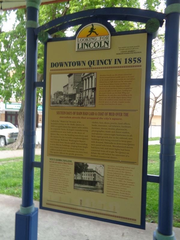
Sixteen days of rain had laid a coat of mud over the macadam streets that wrapped the city's square. Called the "Model City" because of its beautiful setting on the bluffs, Quincy in 1858 occupied about five square miles within . . . — — Map (db m58759) HM
On this exact spot, the corner stone placed in 1910 for the construction of one of the finest; best commercial buildings in this entire area.
Through the years, many very successful businesses were housed here. In later years several very . . . — — Map (db m150028) HM
Lincoln traveled to Quincy by stagecoach in 1854 after crossing the Illinois River at Naples. Lincoln's first documented visit was to support the Congressional candidacy of Archibald Williams and to attack the Kansas- Nebraska Act and . . . — — Map (db m57881) HM
Quincy's brewers and brick makers, contractors and coopers, foundry and factory workers, and diverse other tradesmen made this Mississippi River community an important center of commerce in Lincoln's day. Quincy's businessmen, whose . . . — — Map (db m57883) HM
Pierre Francois Xavier de Charlevoix, a French Jesuit, reported as early as 1721 that the land at the confluence of the Mississippi and Ohio Rivers would be a strategic location for settlement and fortification. Nearly a century later, in 1818, the . . . — — Map (db m144870) HM
Great River Road
The Great River Road in Illinois follows the Mississippi River through the heart of the nation. Discover exciting history, thriving river cultures, beautiful natural areas, abundant wildlife, and bountiful agriculture as you . . . — — Map (db m174555) HM
S.B. Bulkley's first business here was in a frame business house in 1833. In 1840, he tore it down and rebuilt in brick. His clerk, Alexander Buie, later became his partner and the store was enlarged. Buie also sold Bibles in his store. When Daniel . . . — — Map (db m34148) HM
In 1870, W. S. Dann opened a small one room store at this location. Additions were built in 1880 and 1886. Mr. Dann was one of those most interested in the founding of Greenville College. F. P. Joy joined Dann within a few months of the store's . . . — — Map (db m34147) HM
The earliest records show Samuel Colcord's Sorghum Mill once stood here. In 1870 Charles R. Bennett opened his new drugstore. Four drugstores were operating on the square during this time. It was Kate Benneett, Charles' wife, who prevailed on her . . . — — Map (db m34176) HM
In 1912, at age 24, John Posch came to the United States with a dime in his pocket and a bag of tools. In Austria, he had apprenticed for four years as a shoemaker and passed his test to work the trade. In Greenville, he started up his business in a . . . — — Map (db m144104) HM
Constructed as a two story house, this is thought to be the oldest building still standing in Greenville. It as built by Kendall Morse, younger brother of Stephen Morse, who co-founded Almira College. The brothers were some of the most prosperous . . . — — Map (db m144598) HM
This bank was established in August, 1869, by Charles Hoiles and Charles D. Hoiles. In December of 1895 the bank was incorporated as the State Bank of Hoiles & Sons with a capital of $25,000. In September, 1903, the capital stock was increased to . . . — — Map (db m34155) HM
On this northwest corner of the square, the former Hotel Eureka (better known as the Franklin House) once stood. It served as the old stage coach house and was "the best house in town, two stories high, with a double porch on the front, and withal . . . — — Map (db m34185) HM
Built in 1918, this site was headquarters for Wells Judd Tire Sales, a Goodyear Tire Dealer for over 50 years. Managed by Earl Wildermann, it served the local tire and battery trade, as well as customers traveling on the National Trail. Restored in . . . — — Map (db m144108) HM
The village square may be quiet today, but from the mid-1800s through the early 1900s, the ring of hammers bending iron and shaping steel echoed down these streets.
Northwest of where you stand, blacksmiths shaped horseshoes, linked chains, . . . — — Map (db m144110) HM
Where the Illinois Central Railroad saw land it didn't need, Henry Hedrick Smith saw opportunity.
In the mid 1800s, Smith, an ambitious outspoken entrepreneur, bought 800 acres of Bond County prairie from Illinois Central. When the St. Louis, . . . — — Map (db m169984) HM
This ladle was used to pour molten iron into molds, creating cast iron products in Belvidere's National Sewing Machine Company foundry. From the early 1900s, this particular ladle was used to make parts for cast iron toys, washing machines, sewing . . . — — Map (db m199796) HM
Just north of town are remnants of the Cherry Coal Mine, where 259 miners lost their lives in one of the worst mine disasters in United States history.
The St. Paul Coal Company began mining coal at Cherry in 1905 and by 1909 was mining 300,000 . . . — — Map (db m36734) HM
In memory of Bureau County Pioneers. Sunk the first third Vein Coal mine in Hall Township in 1879. Sold in 1888 to C.W. & V. Coal Co. Mine closed in 1913. The town of Seatonville located on land owned by Seaton Brothers was named for them. This . . . — — Map (db m44350) HM
Pioneer resident of Spring Valley. Achieved national prominence in the settlement of the Pennsylvania Anthracite Miners Strike in 1902 with the co-operation of President Theodore Roosevelt.
President of United Mine Workers, 1889-1908. Author . . . — — Map (db m164894) HM
[Sign #1]
Anatomy of a Canal: Canals like the Hennepin are manmade waterways for boats to travel on. Many canals are built to make shortcuts between two existing bodies of water. The Hennepin Canal was built to carry cargo barges . . . — — Map (db m44828) HM
Steamboats once navigated to this point, where Plum River Falls powered saw, powder, grist, and flour mills at various times between 1836 and 1885. Near here the Rock Island Military and Prophetstown Trails to Galena were intersected as early as the . . . — — Map (db m34261) HM
This property is listed in the
National Register of Historic Places
by the
United States Department of the Interior
May 11, 2000
Beardstown Grand Opera House
c.1872
Heritage Preservation
Foundation
“Preserving our . . . — — Map (db m229612) HM
Abraham Lincoln had just won an acquittal for his client William Duff Armstrong in what is now known as the celebrated Almanac Trial of May 7, 1858. At the conclusion of the trial, held on the second floor of the Cass County Courthouse . . . — — Map (db m57858) HM
Travel in Abraham Lincoln's time was time-consuming, dirty, and usually downright uncomfortable. On many of his trips, Lincoln traveled by train to Meredosia. From there he had the choice of a steamboat or a bone-jarring ride in a . . . — — Map (db m57863) HM
On the Bloomington Road
The Fort Clark Road, later known as the Bloomington or State Road, was an important artery for commerce between Danville and Urbana. The road was first approved in 1826 by the Illinois Assembly. It was the first . . . — — Map (db m23850) HM
Kelley’s Tavern was originally called Strong’s Inn after Cyrus Strong, who built a mud-mortar log cabin here in the 1830's. The inn at Strong’s Ford was a stop on the Bloomington or State Road from Danville west to Urbana. Kelley’s Inn was a stop . . . — — Map (db m23803) HM
Combining the administrative and computer experience of Louis N. Ridenour, the mathematical ability of Abraham H. Taub, and the electrical engineering background of Ralph E. Meagher, in 1952 the Digital Computer Laboratory developed ILLIAC I. The . . . — — Map (db m225548) HM
The Cohen Building was designed by noted local architect Joseph W. Royer for prominent Urbana businessman and cigar manufacturer Nathan (Nat) H. Cohen. Other major downtown buildings designed by Joseph W. Royer include the Urbana Free Library, the . . . — — Map (db m226012) HM
It's a story often told on the National Road. Two towns, both poised to prosper, grow up within walking distance of one another. One thrives. The other fades into the footnotes of history.
In the 1830s, Ewing Chancellor settled land along an . . . — — Map (db m152559) HM
With the opening of the National Road through this area, small communities began to the established along the route, one of which was Casey. The first settler was John Lang, a native of Scotland. Lang and family arrived from Ohio in 1838 and bought . . . — — Map (db m152488) HM
Hiram B. Trout and his brother, Everett Trout, were born on a farm about five miles north of this location. They operated a machine shop in Shelbyville, Illinois in the late 1800’s at which in time they invented and patented the unique design for . . . — — Map (db m59336) HM
Has been placed on the
National Register
Of Historic Places
November 4, 2001
By the United States
Department of the Interior
Built 1872
— — Map (db m152565) HM
1904 Johnson Hall
1920 Hercules Paint Store & Sane Crystals
1954 Loyal Order Of Moose Lodge No. 1708
2008 Historic National Road Welcome Center — — Map (db m229786) HM
Built at the intersection of Illinois' first state road and America's first federal highway, Marshall was a gateway community for immigrants traveling west. It was founded in 1835 by Illinois Gov. Joseph Duncan and Col. William B. Archer. . . . — — Map (db m152562) HM
This structure was erected in 1841 by Col. Wm. B. Archer, founder of Marshall, and John Bartlett and has been in continuous use as a hotel. It was an important stage coach stop on the early Cumberland Road where many prominent people, including . . . — — Map (db m152564) HM
Imagine you're traveling the National Road in the late 1800s. Your wagon is one of many trundling toward town. The dirt road is rough and the ride uncomfortable, but you welcome the trip. It's a day to visit with friends, catch up on news, and trade . . . — — Map (db m152560) HM
The Linn Family
The ancestors of the Linn Family immigrated from Ireland in 1809. They eventually settled in Parker Township in Clark County Illinois, near Westfield in 1864. Walter Linn and his family moved to Martinsville in the late . . . — — Map (db m242006) HM
On March 25, 1947, a violent explosion struck Centralia Coal Company Mine No. 5, located in Wamac, Illinois. By March 29, it was confirmed that the explosion, combined with the subsequent release of poisonous gas had taken the lives of 111 of the . . . — — Map (db m185507) HM
The City of Breese was named after Sidney Breese, Chief Justice of the Supreme Court of Illinois. This community owes a debt of gratitude to our ancestors who came to Breese when it was only a wide place in the road. Today, in 2008, the City . . . — — Map (db m178657) HM
Growth of a Railroad Town
"Where a great way from the northern plain
Meets one from the deltas of cotton and cane;
…
Where the steeds of those great iron highways meet
To unload the wealth of the world at her feet,
The Queen of . . . — — Map (db m189025) HM
The Big Dig and Beyond
In 1914, to eliminate congestion and travel delays, the Illinois Central Railroad began construction of the subway. ICRR demolished several buildings, including the landmark Essex House and Union Depot. They laid the . . . — — Map (db m189034) HM
This mural embraces the landscape, history and people of Mattoon. For years after the completion of the rail, many trains a day would meet at the intersection of the tracks at the center of town and determine right of way in polite fashion. This . . . — — Map (db m188431) HM
Bagelfest
After Kraft purchased the Lender's Bagel Company in 1984, the local plant shifted production. Not only did Mattoon become one of the world's leading producers, but bagels became an important part of the City's national identity. . . . — — Map (db m189056) HM
Oil Boom
In the 1940s, Mattoon became a hub for the oil industry. Companies large and small opened offices here, attracted by the developing oil fields, the business environment, and the quality of life. The oil business brought new people . . . — — Map (db m189055) HM
On this spot stood the Clapboard Inn, General Store, and Post Office of the early settlers, including the Lincoln family.
The survey of the Village shows thirty-seven lots. Main Street, sixty feet wide, ran immediately with the State Road and . . . — — Map (db m10991) HM
The Buckle on the Corn Belt
In the early 1920s Mattoon was proclaimed "The Buckle on the Corn Belt." This slogan was used to encourage people and businesses to settle here. Like any developing city, Mattoon met its share of challenges, . . . — — Map (db m189054) HM
A Prairie Landscape Heritage
Tribes of Pottawatomie, Kickapoo, and Winnebago were known to have inhabited the region, but the first settlers of Mattoon found mostly open prairie. Timber was scarce and early settlers could see for miles, . . . — — Map (db m188951) HM
Gristmill Stone Recovered from the
Little Embarras River South of Oakland
about 1936. Donated to the City of Oakland
by the Curtis Family in memory of Walter A. and
Georgia (Swinford) Curtis.
Mill was in use about 1850. — — Map (db m30885) HM
This corridor was a gateway into the country’s interior. Several well worn Indian trails were traveled by fur traders and explorers. One trail, the future Ogden Avenue, was improved into a plank toll road creaking beneath the weight of settlers’ . . . — — Map (db m157105) HM
Route 66 was a traveling showroom for new cars in the 1950s. Bold design, streamlining, chrome, and flaring fins captured people’s imagination. Ogden Avenue became a hub for automobile businesses in the Chicago area. In its heyday, the strip . . . — — Map (db m157677) HM
(front:)
Route 66, the Mother Road, is an American icon that symbolizes romance and freedom of the open road. Born in 1926, Route 66 was one of the first numbered U.S. highways, journeying 2,500 miles from Chicago to Los Angeles. Today, . . . — — Map (db m159132) HM
Ogden Avenue was designed for automobiles when the car was king of American culture. A wide street lined with drive-through businesses and convenient parking served both travelers and residents. Drive-in restaurants, service stations, and auto . . . — — Map (db m157675) HM
Looking for a quick bite? After World War I, fast food restaurants sprang up along Route 66, offering cheap and speedy meals for people on the go. Ogden Avenue is still home to many restaurants that were popular during the heyday of the Mother . . . — — Map (db m157676) HM
Milly's Pizza in the Pan opened in 2020. The former ghost kitchen turned restaurant is a tribute to its namesake, Robert's grandmother, who taught him how to cook.
We handcraft a limited number of pizzas each day to ensure quality that would . . . — — Map (db m247361) HM
Two blocks north of this corner the funeral train of President Abraham Lincoln entered Illinois at approximately 10:15 a.m. on May 1, 1865, on the Michigan Central Railroad right-of-way.
In the autumn of 1869, the founders of the State Line . . . — — Map (db m229880) HM
Historien Om
[the story of]
The story of Andersonville begins as a cherry orchard In the 1850s and evolves throughout the years, adding several layers of identity: first as a Swedish settlement on the outskirts of . . . — — Map (db m235738) HM
This building is a significant early 20th-century industrial building built for one of Chicago's best-known manufacturers. Founded and headquartered in the city for many years, the Florsheim Shoe Company was one of the nation's leading shoe . . . — — Map (db m94316) HM
[Front of the marker:]
The Union Stock Yard and Transit Company, Chicago's legendary livestock market and slaughterhouse, opened at this site on Christmas Day, 1865. Here, 320 acres of swampland lying between Pershing Avenue, Halsted Street, 47th . . . — — Map (db m244189) HM
At one time sprawling over 475 acres, the Union Stock Yard thrived for more than a century, then closed entirely. This rugged gate, erected in 1875, survives as one of the few visual reminders of Chicago's past supremacy in the livestock and . . . — — Map (db m244150) HM
Entrepreneurs in Historic Canaryville
The primary catalyst for the establishment of Canaryville was the opening of the Union Stock Yards and the organization of the Union Stock Yard & Transit Company in 1865. Two young entrepreneurs arrived in . . . — — Map (db m244233) HM
Chicago Bee Building
Z. Erol Smith, architect
1929-31
This Art Deco-style building was constructed as
the headquarters for the Chicago Bee newspaper,
which was founded by noted African American
entrepreneur Anthony Overton. It also . . . — — Map (db m188754) HM
Overton Hygienic Building
Built 1922-23
Built as the headquarters for the Overton
Hygienic Co., one of the nation's foremost
producers of African-American cosmetics, this
structure also housed the Victory Life Insurance
Company and . . . — — Map (db m180693) HM
State Street was the shopping district of
Black owned businesses such as drugstores,
barber shops, flower shops, tailor shops,
meat markets, millinery shops, fruit stands,
theaters, and restaurants,
a “city within a city."
This area . . . — — Map (db m189133) HM
Supreme Life Building
Built 1921; remodeled 1950
This was the longtime headquarters of the Supreme Life Insurance Co., the first African-American owned and operated insurance company in the northern United States. The firm was founded in . . . — — Map (db m188528) HM
In 1770, a Black man, Jean Baptiste Pointe DuSable,
began trading goods with Native Americans.
DuSable High School honors him. By 1840, Blacks
settled in Chicago's “Black Metropolis"
now known as Bronzeville.
(panel two:)
The . . . — — Map (db m187382) HM
During the 1960's Chicago's 'Barmaids Ordinance'
prohibited women, unrelated to the owner,
from tending bar in Chicago.
In 1970, the owners of this
establishment hired airline
Stewardesses to tend bar in
defiance of City Ordinance. . . . — — Map (db m180591) HM
The 1870 marriage of Bertha Honore and Potter Palmer united two of the wealthiest and most influential families of 19th century Chicago. Both were strong-willed individualists who used their economic power and social positions to carry out their . . . — — Map (db m188620) HM
This is the 1000th Walgreen Drugstore. Walgreen Co. was founded in 1901 on Chicago’s South Side by Charles L. Walgreen, Sr. A replica of the original store can be seen at the Museum of Science and Industry, Chicago, Illinois. — — Map (db m180342) HM
Originally built as the Palace of Fine Arts for the World's Columbian Exposition, this plaster-clad structure later became the first home of the Field Museum of Natural History. After the museum left in the 1920s, the decayed building was . . . — — Map (db m238465) HM
Physicist Enrico Fermi and his colleagues established the first self-sustaining controlled nuclear reaction in makeshift laboratories constructed under the grandstands of Stagg Field Stadium on December 2, 1942. The success of this experiment . . . — — Map (db m69608) HM
Julius Rosenwald
Businessman and philanthropist
1862 - 1932
Sears, Roebuck & Company became a household
name because of the energy and vision of Julius
Rosenwald. He developed Sears’ mail-order
business when much of the nation . . . — — Map (db m188774) HM
This terra-cotta-clad flat-iron building makes the most of its triangular building lot. Like many neighborhood banks from the 1920s, the Marshfield Trust and Savings Bank employed the Classical Revival style of architecture to convey a sense of . . . — — Map (db m208809) HM
”A true Bavarian Chalet in Chicago,” owned and operated by the Albert Wirth family and recognized as an outstanding dining and banquet facility, Zum Deutschen Eck was founded on June 16, 1956. On January 9, 2000 ZDE retired after 44 . . . — — Map (db m82400) HM
Ruth Ellis
Businesswoman and Senior Lesbian Activist
(1899 - 2000)
Ruth Ellis was born in Springfield, Illinois to parents who were conceived in the last years of slavery. Her life spanned through moments of great turmoil and . . . — — Map (db m182819) HM
Side One
By the 1930s, the market was thriving, attracting 50,000 people on a typical Sunday. Depression-Chicagoans were in dire need of low-priced food clothing, and other everyday household goods. Maxwell Street provided an arena for budding . . . — — Map (db m122809) HM
Built by the Studebaker company for the assembly and display of their carriages and wagons, this building was converted into studios and theaters for artists and craftsmen in 1898. The interior public spaces, featuring murals on the tenth floor, . . . — — Map (db m237986) HM
[side 1]
Chicago’s Great Street
There is only one State Street. Widely celebrated in song, “That Great Street” has been known since the 1870s for its concentration of premier department stores and world-class architecture. . . . — — Map (db m240288) HM
Established in 1934 the Billy Goat Tavern, was located across from the original Chicago Stadium, it was from there William 'Goat' Sianis, put the Curse on the Chicago Cubs.
In 1964 the Billy Goat moved to Michigan Avenue. It was the . . . — — Map (db m237394) HM
Established in 1934 the Billy Goat Tavern, was located across from the original Chicago Stadium, it was from there William 'Goat' Sianis, put the Curse on the Chicago Cubs.
In 1964 the Billy Goat moved to Michigan Avenue. It was the . . . — — Map (db m237395) HM
Cyrus McCormick revolutionized farming. Taking up his father’s interest in agricultural technology, he invented the horse-drawn mechanical reaper in 1831. He was 22. Three years later, he patented it, but he worked another six years to improve it . . . — — Map (db m234728) HM
Following the Great Chicago Fire of 1871,
Old Town evolved from a farming community
into a commercial area reflecting the diverse
skills and trades of the Old Town population at
the turn of the century. Some businesses of
note include: The . . . — — Map (db m188296) HM
In the early 1800s and 1900s, Old Town was a thriving community of immigrants, laborers, brewers and civic leaders who contributed to the early success of Chicago.
William B. Ogden – resident of Old Town and first mayor of Chicago from . . . — — Map (db m47607) HM
From 1870 through the 1800s, Henry Piper, one of Old Town’s early entrepreneurs, operated a successful bakery in a narrow alley. Today, the building at Wells and North is known as Piper’s Alley. The existing house located at 1546 North Wells was . . . — — Map (db m47609) HM
In 1889, the world's largest bicycle maker,
Western Wheel Works, opened at 1350 North Wells.
During this time, Dr. William Scholl rented space
in the bicycle factory and began manufacturing
shoes. In 1900, Western Wheel Works closed
and Dr. . . . — — Map (db m188294) HM
This handsome building originally served as the Midwest office, warehouse and distribution center of the American Book Company, a nationally-prominent textbook publisher. Typical of industrial architecture of its time, this reinforced-concrete . . . — — Map (db m69594) HM
Chess Records Office and Studio
Horatio R. Wilson, architect
2120 S. Michigan Avenue is internationally known as the site of some of the most influential Blues and Rock 'n' Roll recordings, including "Johnny B. Goode," "Rescue Me," and . . . — — Map (db m188622) HM
George Pullman established his reputation in Chicago in 1859 by inventing a way to raise buildings to the new street level required for installation of a sewer system.
In 1863, he began converting railroad passenger cars into luxury sleeping . . . — — Map (db m99944) HM
A mature Richardsonian design, Glessner House is famous for its site development, innovative floor plan and rugged Romanesque facade. Glessner House, a reminder of the fabulous Prairie Avenue era, is the only remaining Chicago building by this . . . — — Map (db m69586) HM
723 entries matched your criteria. The first 100 are listed above. Next 100 ⊳