650 entries match your criteria. The first 100 are listed. Next 100 ⊳
Maryland Historical Trust Historical Markers
Launched in 1933, the roadside historical marker program has proven an effective way to draw attention to the many events, people and places that have contributed to the richness of our state and nation. The marker program is administered in cooperation with the Maryland State Highway Administration.
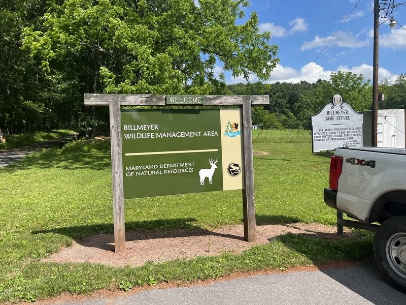
656 acres, purchased December 15th, 1923, from Frank Billmeyer; from Hunter's License Fund, for the purpose of propagating game. — — Map (db m199927) HM
Near this point, on June 10, 1755, after nearly a month's delay at Fort Cumberland, Braddock's troops started towards Fort Duquesne to wrest it from the French. On July 9, 1755, he met his terrible defeat at the Monongahela. — — Map (db m155433) HM
One of the most picturesque spots around Cumberland. Discovered by Spendelow after the road over Wills Mountain had been constructed by General Braddock. Adopted as the route of the Cumberland Road (The National Road) 1833. The old stone bridge . . . — — Map (db m187070) HM
A log chapel dedicated to St. Mary was built on this site in 1791. The first parishioners were mostly English Catholics from Southern Maryland. A brick church replaced the log building in 1939. Cumberland became a major center of transportation and . . . — — Map (db m134394) HM
Here in Evitts Creek Valley
on August 1, 1864,
General McCausland's Confederate
cavalry, returning after burning
Chambersburg, was surprised by
General Kelley's Union troops from
Cumberland. The Confederates
were repulsed and retreated . . . — — Map (db m19320) HM
On this site originally stood the Headquarters of George Washington, since removed to Riverside Park. He was entertained at David Lynn's house (which later occupied this site) when he came here in 1794 to review the troops during the Whisky . . . — — Map (db m155434) HM
Jane Frazier
wife of
Lieut. John Frazier
was captured by Indians near this spot in October 1755 and taken to the Miami River. She escaped after eighteen months and made her way back to her home. — — Map (db m402) HM
The store houses of The Ohio Company were first located near this point. In 1754 the first fort (called Mt. Pleasant) was built. Gen'l. Edward Braddock enlarged the fort in 1755 and renamed it after his friend the Duke of Cumberland. — — Map (db m167130) HM
Here the Indian envoys were received before Braddock left for his defeat. In 1756-58 the garrison under Col. Washington was still reviewed here. — — Map (db m17453) HM
By order of Colonel Bouquet, George Washington’s troops opened this road from Fort Cumberland to Reas-town (Bedford, Pa.) during July 1758. Bouquet and Washington conferred half-way between these places July 30, 1758. — — Map (db m166865) HM
War path of the five nations from central New York to the Carolinas. One of the longest Indian trails in America, crossed this highway about this point. — — Map (db m3489) HM
50 acres, purchased December 13, 1930, from Perry Barnes and wife; from Hunter's License Fund for the purpose of propagating game. — — Map (db m199926) HM
Dickerson African Methodist Episcopal Church (AMEC), formerly Hall's Chapel, was established in 1845 on Ormand Street in in Brownsville. The church was rebuilt and relocated in 1881 on land donated by Thomas Mitchell at W. Mechanic and Pine . . . — — Map (db m296265) HM
During colonial exploration and settlement the valley provided a route to the western frontier. In 1753, preceding the French and Indian War, George Washington traveled this route to deliver Gov. Dinwiddie's order that the French abandon their . . . — — Map (db m84736) HM
General Braddock's 2nd camp on the march to Fort Duquesne June 14th, 15th, 1755. The old Braddock Road passed to the southeast of the National Road from Clarysville to the "Shades of Death" near "Two Mile Run." The National Road was begun by the . . . — — Map (db m177600) HM
General Braddock’s 1st camp on the march from Fort Cumberland to Fort Duquesne, June 11th to 13th, 1755. After building a road over Wills Mountain, Spendelow, an engineer, discovered a route by “The Narrows” and Braddock’s Run and a second road was . . . — — Map (db m2083) HM
First toll gate house on the old National (Cumberland) Road. Erected about 1833 after this portion of the road was turned over to the State of Maryland by the United States government. There was one other toll gate in Maryland on this Road. — — Map (db m442) HM
Was the first of the internal improvements undertaken by the U.S. Government. Surveys were authorized in 1806 over the route of “Braddock’s Road,” which followed “Nemacolin’s Path,” an Indian trail, over which George Washington traveled in 1754 to . . . — — Map (db m167131) HM
In 1844, the first iron rails made in the United States were produced on this spot by the Mount Savage Iron Works. Erected in 1839, the iron works contributed extensviely to the development of the Mount Savage Community. — — Map (db m5846) HM
The first iron rails made in the United States were manufactured in 1844 at Mount Savage. Before that time all iron rails were imported from England. — — Map (db m445) HM
He built his house, which can be seen nearby, about 1764. A trader, he cleared wilderness and fought Indians in “Cresap’s War” in Ohio, 1774. As a Captain he led riflemen, some painted Indian-style, to Boston at the start of the Revolution. Because . . . — — Map (db m448) HM
Fording place for “Great Warriors Path” from New York to the South. Thomas Cresap built stockade fort here in 1741 used as a refuge during French and Indian War after Braddock’s defeat.
George Washington
was here on his first visit to . . . — — Map (db m447) HM
On March 25, 1655, colonial Governor William Stone landed Maryland militia at the Puritan settlement of Providence, located at the mouth of the Severn River. He planned to subdue the settlers who had asserted their independence from the . . . — — Map (db m309692) HM
In this state house, oldest in the nation still in legislative use, General George Washington resigned his commission before the Continental Congress December 23, 1783. Here, January 14, 1784, Congress ratified the Treaty of Paris to end the . . . — — Map (db m2864) HM
In this state house, oldest in the nation still in legislative use, General George Washington resigned his commission before the Continental Congress December 23, 1783. Here, January 14, 1784, Congress ratified the Treaty of Paris to end the . . . — — Map (db m6703) HM
In this state house, oldest in the nation still in legislative use, General George Washington resigned his commission before the Continental Congress December 23, 1783. Here, January 14, 1784, Congress ratified the Treaty of Paris to end the . . . — — Map (db m268680) HM
During the Revolutionary War, 1200 Continental Light Infantrymen under the command of Marquis de Lafayette encamped on the rise behind this sign en route to the decisive battle in Yorktown, Va. They arrived in Annapolis from Head of Elk by a . . . — — Map (db m270318) HM
Chartered in 1865 by the Maryland General Assembly after a fire at the State House in 1863. Waterworks began operation in 1866, designed by noted civil engineer William Rich Hutton, who had recently completed Washington Aqueduct. Innovative concrete . . . — — Map (db m51852) HM
Located in this vicinity, one of three camps established during the Civil War to accept paroled Union prisoners of war for Confederate prisoners similarly confined in the south. Over the course of the war, thousands of soldiers were held here until . . . — — Map (db m66303) HM
Patented August 25, 1664, to Edward, Joshua, and John Dorsey, sons of Edward Dorsey who settled in Maryland in 1650. The patent was signed by Charles Calvert, then Lieutenant General, and later Third Lord Baltimore. This plantation has been the . . . — — Map (db m2906) HM
Across the road stood the three mile oak under which General George Washington passed on his way to Annapolis December 19, 1783 to resign his commission as Commander in Chief of the Continental Armies. According to tradition, General Smallwood, . . . — — Map (db m76022) HM
French troops under Count de Rochambeau made their 36th camp here September 16-17, 1781, enroute to Yorktown, Virginia. Most of the troops embarked from Annapolis, but the artillary marched to Georgetown to cross the Potomac River. — — Map (db m2928) HM
This tobacco plantation wasbuilt ca. 1736 by John Ross and owned by the Scotts, Worthingtons, and Welshes. On September 17, 1781, Comte de Rochambeau camped here en route to Yorktown, VA during the American Revolution. Many enslaved Black . . . — — Map (db m306042) HM
Count de Rochambeau’s troops marched over this road from Spurrier’s Tavern to “Scott’s Plantation” (Belvoir) on Sept. 16, 1781 on the way to Yorktown. Washington and Rochambeau had gone ahead Sept. 10–11 on the way to Mt. Vernon. — — Map (db m2890) HM
At this site, anonymously buried slaves were found during road construction in 1960. These unclaimed individuals were associated with the Locust Grove plantation founded by 1848. The remains were reburied at Mt. Tabor Church in nearby Chesterfield. . . . — — Map (db m251442) HM
Surveyed, 1663, as Holland’s Hills for Francis Holland; bought 1665, by Richard Harrison, Quaker planter and shipowner, who owned about 6,000 acres. The house, built in three stages between 1665 and 1733 by Richard Harrison and his son Samuel, is . . . — — Map (db m2938) HM
Cedar Park
Patented to Richard Ewen in 1666 as “Ewen upon Ewenton.” Brick house built c.1697 by Richard Galloway II around earlier frame structure possibly dating back to 1656. Known as “West River Farm” in 18th Century. Home and burial place . . . — — Map (db m65889) HM
William Penn attended a meeting of the Friends (Quakers) at Thomas Hooker’s December 1682 on this tract called “Brownton” (patented in 1652 for 660 acres). Penn sailed from here across the Bay to the Choptank River to a General Meeting of the . . . — — Map (db m260455) HM
In 1950, President Harry S. Truman dedicated Friendship International Airport. The state of Maryland purchased the airport in 1972 from Baltimore City for $36 million, later renaming it Baltimore/Washington International Airport. In 2005, it was . . . — — Map (db m290664) HM
Consecrated Sunday, November 4, 1951, by the joint congregations of Friendship and Ridge Methodist Churches.
Timber Ridge and Friendship Methodist Churches
Timber Ridge Church was built c.1840 two miles to the east. It . . . — — Map (db m3036) HM
An African American community and church were established nearby in the mid 19th century. In 1918 the Benevolent Sons and Daughters of Abraham, a mutual aid society, purchased and donated land on this site for a two-room school which was built . . . — — Map (db m49729) HM
Charles Lord Baltimore and his council attended the meeting of the Assembly here Oct. 2 – Nov. 6, 1663. 31 towns and ports of entry were established at this session in the several counties along the bay. Practically none of these towns exist at the . . . — — Map (db m2945) HM
Jonathan Rawlings given a license to keep an “ordinary” (tavern) in 1771.
George Washington
dined here September 26, 1773, on his way to the Annapolis races. — — Map (db m3141) HM
Came here to the home of Col. Thomas Tailler on "the ridge" December 13, 1682 for his first conference with Charles Lord Baltimore as to the location of the boundary line between Maryland and Pennsylvania. — — Map (db m255621) HM
Built circa 1820, the Benson-Hammond House is the headquarters of the Ann Arundell County Historical Society and is open to the public.
Annapolis and Baltimore Short Line
Organized in 1880, the Annapolis and Baltimore Short Line ran its . . . — — Map (db m253477) HM
Growth of railways advanced the development of suburban communities in the early 20th century. Linthicum Heights was platted in 1908 along two interurban railroads by the Linthicum family to take advantage of direct transportation to Washington, . . . — — Map (db m8142) HM
Portland Landing
and
Saint Jerome's
Surveyed 1700
Owned by Col. Henry Darnall
brother-in-law of Charles,
3rd Lord Baltimore and
Secretary of State. — — Map (db m3142) HM
The first church on this site was built, 1695, and the present structure was completed 1765. The Reverend Henry Hall (1675–1722) served as the first rector, 1698-1722. From 1786–1792 Saint James’ was the home parish of Thomas John Claggett . . . — — Map (db m3143) HM
Adam Shipley came to Anne Arundel County in 1668.
On March 30, 1681, 200 acres were surveyed and patented in his name. This tract was the earliest patented in the Shipley name. Marker was dedicated during the development of the subdivision . . . — — Map (db m265121) HM
Adam Shipley, who came to Anne Arundel County in 1668, on March 30, 1681, patented 200 acres on the south side of the Severn River. Dedicated during the Tercentenary Commemoration of the Shipleys of Maryland. May 25, 1968. — — Map (db m265122) HM
Adam Shipley, who came to Anne Arundel County in 1668, on March 30, 1681, patented 200 acres on the south side of the Severn River. Dedicated during the Tercentenary Commemoration of the Shipleys of Maryland. May 25, 1968. — — Map (db m80457) HM
Built as a Methodist Church in 1861 and used as the Church Sanctuary & Sunday School for fifty years. Moved in 1896 from SE to NE corner of General’s Highway and Indian Landing roads, and dedicated in 1935 to Charles W. Baldwin, its pastor for 71 . . . — — Map (db m260082) HM
Near here was junction of old Baltimore-Annapolis Road (“Generals Highway”) and a road laid out by Charles Carroll from Doughoregan Manor. On the south side of Severn Run stood Widow Ramsey’s where George Washington breakfasted June 7, 1773, and . . . — — Map (db m2888) HM
Only known World War I chapel in the United States. Consecrated in 1918 to minister to the soldiers at Camp Meade and serve as permanent mission in the village of Odenton. Designed in the Arts and Crafts style by Riggin Buckler. Used by all . . . — — Map (db m3162) HM
Masonic temple served as the meeting place of Odenton Lodge 209, Ancient Free and Accepted Masons, from 1912 to 2001. Local masons constructed the temple in the fashionable Colonial Revival style as Odenton experienced a period of explosive growth. . . . — — Map (db m295722) HM
Established in the mid 19th century on land owned by Capt. James Spencer, who served in the Union Army during the Civil War, Freetown illustrates the principles of self-sufficiency and cooperation typical of African American communities. The first . . . — — Map (db m13567) HM
One of the first Methodist societies in Anne Arundel County. Log church originally erected on tract acquired in 1764, now the cemetery. Bishop Francis Asbury preached here August 27, 1777. Church built on present site in 1859 was destroyed by fire . . . — — Map (db m2863) HM
WB&A Road was constructed on the right-of-way of the main line of the Washington, Baltimore & Annapolis Electric Railroad. Using the most advanced technology of the time, the high-speed line provided passenger and freight service between . . . — — Map (db m35050) HM
Born in England about 1603, he emigrated to Virginia about 1628, and he came to Maryland about 1648. He brought with him nine settlers, and many others followed. He obtained about 5,000 acres located in St. Mary’s, Charles and Calvert counties.
. . . — — Map (db m2889) HM
All Hallows Parish, South River, one of the original thirty parishes created by law in 1692 when the Anglican Church was established in Maryland. The present Georgian church was built c. 1730. Several prominent London Town merchants are buried in . . . — — Map (db m2941) HM
Here April, 1672, George Fox, founder of Quakerism, opened the first General Meeting of Friends in Maryland, marking the beginning of West River Yearly Meeting and its successor, Baltimore Yearly Meeting of Friends. Site of West River Quaker Meeting . . . — — Map (db m3038) HM
Congregation of the Sisters of Bon Secours, a nursing order founded in France in 1824, sent three members to Baltimore in May, 1881, at the request of Cardinal Gibbons. Their first U.S. convent opened at West Baltimore and Payson Streets the . . . — — Map (db m2451) HM
Named for Quartermaster General Samuel B. Holabird (1826-1907) and established in 1917 as the Army's first motor transport training center and depot. Supplied World War I American Expeditionary Forces in France with Detroit-made vehicles. Trained . . . — — Map (db m294810) HM
Through the efforts of the Canton Improvement Association this old and densely populated ethnic neighborhood was named to the National Register of Historic Places in 1978. The two-story red brick row houses are especially noteworthy for their hand . . . — — Map (db m184476) HM
This branch of the Enoch Pratt Free Library was built in and opened for use in 1886, one of four given to the city of Baltimore by Enoch Pratt, a great philanthropist of that era. It is the only one of that group still in use as a library. Pratt . . . — — Map (db m2450) HM
The burial place of Methodist pioneers including Bishops Francis Asbury, Enoch George, John Emory and Beverly Waugh, also Robert Strawbridge, first preacher in Maryland and Jesse Lee, founder in New England. Site of 1966 Methodist Bicentennial time . . . — — Map (db m33697) HM
Since the founding of Baltimore, 1729, this hill has been a popular point for viewing the city’s growth. Here 4,000 people feasted 1780, to celebrate the ratification by Maryland of the Federal Constitution and in honor of the new government gave . . . — — Map (db m2555) HM
Part of “Merryman’s Lott” 210 acres of virgin timberland granted by Lord Baltimore in 1688 to Charles Merryman, whose descendants farmed here until 1869. Stone house built in 19th century occupied by Bishops of Maryland since 1909, when cathedral . . . — — Map (db m2452) HM
Surveyed for John Walsh in 1754, large square cupola once crowned brick mansion. Built in Italianate style c.1860 by Henry Snyder. Leased after 1864 to James Hooper, owner of Meadow Mill. Estate was sold in 1870 to David Carroll, co-owner of Mount . . . — — Map (db m2520) HM
Property purchased in 1800 by Charles Carroll, signer of the Declaration of Independence, as a wedding present for his only son, Charles and bride Harriett Chew of Philadelphia. The younger Charles designed and oversaw the building of the . . . — — Map (db m18315) HM
Although the United States banned the Transatlantic Slave Trade in 1808, a domestic trade from the Upper South to the emerging cotton-growing regions of the Deep South thrived until the 1860's. Baltimore-based dealers supplied the trade, operating . . . — — Map (db m71935) HM
Established as a port of entry in 1706, this peninsula was originally known as Whetstone Point. Along this road in 1814, soldiers marched to the defense of Fort McHenry, nearby. Port facilities served as a Federal supply camp in the Civil War. . . . — — Map (db m264015) HM
Originally the estate of Major General Samuel Smith (1752-1839). In 1881 Lake Montebello began service as a drinking water supply for Baltimore when connected by tunnel with Loch Raven reservoir. Montebello water filtration plant was completed in . . . — — Map (db m96029) HM
Morgan Park was the first planned Black suburb in Baltimore city. In 1917, Morgan State University President Dr. John O. Spencer envisioned Morgan Park as a community for Black faculty and professionals barred from purchasing homes in nearby white . . . — — Map (db m250746) HM
On this site, May 20, 1911, Ernest Thompson Seton, founder of the Boy Scouts of America, laid the cornerstone of the first Boy Scout Armory in the United States, and 30 acres of land were presented to the Mount Washington Boy Scouts for park and . . . — — Map (db m114583) HM
On hill to the north stood the Georgian mansion built c. 1775 by Daniel Bowley II (1745–1807), Baltimore merchant and patriot of the revolution. He was a town commissioner, 1771–1778, and three times a State Senator. In 1814, British soldiers . . . — — Map (db m242400) HM
During the War of 1812, a circular 180° earthen artillery redoubt was erected as a defense for Fort McHenry. On September 13, 1814, Lt. George Budd commanded naval forces that assisted in repulsing a nighttime British attack on the Ferry Branch . . . — — Map (db m36849) HM
The Home for Incurables of Baltimore City, was incorporated November 1, 1883, through leadership and resources provided by the men and women of the Hospital Relief Association of Maryland. The purpose of this organization, incorporated December 18, . . . — — Map (db m2387) HM
One of nation’s oldest planned garden suburbs. Named for Roland Thornberry, a Baltimore County landowner. English investors backed 100-acre development proposed by William Edmunds and Edward H. Boulton, and the Roland Park Company was incorporated . . . — — Map (db m2524) HM
Babe Ruth was born in 1895, a few blocks northwest of here on Emory Street. In 1902 the seven-year-old was sent to Saint Mary's Industrial School, a home for unwanted children in southwest Baltimore. On the school's playfields he became an . . . — — Map (db m136346) HM
The first national strike began July 16, 1877, with Baltimore and Ohio Railroad workers in Martinsburg, West Virginia, and Baltimore Maryland. It spread across the nation halting rail traffic and closing factories in reaction to widespread worker . . . — — Map (db m63862) HM
Henry G. Parks, Jr., entrepreneur and civil rights pioneer, founded the Parks Sausage Company in 1951. On this site, Parks built a facility that employed 270 workers while advancing integration and equity in the workplace. Parks distributed products . . . — — Map (db m192383) HM
Wrestling was a popular sport in Maryland in the early 20th century. Baltimore was the base for nationally known professionals Gus “Americus” Schoenlein, Frank “Shad” Link, Frank Lynch, Harry Scroggs, “Kid” Taylor and Anthony “Columbus” Wallnoefer, . . . — — Map (db m60957) HM
Davidge Hall, constructed in 1812, is named for the first dean of the University of Maryland School of Medicine, Dr. John B. Davidge. Noted for its unique classical appearance, it is the oldest building in the country used continuously for medical . . . — — Map (db m15057) HM
This structure, now the east building of Church Hospital, was erected in 1836, to house the Washington Medical College. Edgar Allan Poe, author, and poet, was brought here, ill and semi-conscious, on October 3, 1849 and died four days later. In . . . — — Map (db m2426) HM
Oldest cemetery for African Americans in Baltimore, founded in 1872 by Rev. James Peck, pastor, and trustees of Sharp Street Methodist Episcopal Church. Dating to 1787, the congregation served the community and was influential in the freedom . . . — — Map (db m13540) HM
500 acre grant in 1704 to Thomas MacNemara. Later called “Sweet Air.” Charles and Daniel Carroll, MacNemara’s kinsmen, acquired the property and sold it in 1751 to Roger Boyce, who built the present house. It was purchased in 1785 for . . . — — Map (db m2052) HM
In this valley 7031 acres laid out, 1683, for Charles, Third Lord Baltimore. Opened to settlers, 1721 by Charles, Fifth Lord Baltimore. Frederick, Sixth Lord Baltimore, ordered manor sold, 1766. Land remaining 1782 seized and sold as confiscated . . . — — Map (db m129902) HM
The first inhabitant of this village, dating back to 1706, was Richard Gist, father of the Revolutionary War hero, Mordecai Gist. The industrial development of the Jones Falls Turnpike Road, circa 1806, and later by the Baltimore and Susquehanna . . . — — Map (db m2272) HM
Marble from this quarry, located about a mile to the south, was used to build the Washington Monument in Baltimore. Designed by architect Robert Mills and erected between 1815 and 1829. This was the first public monument erected to George . . . — — Map (db m137696) HM
On September 10, 1935, Black students Lucille Scott and Margaret Williams were denied admittance to Catonsville High School. NAACP attorney Thurgood Marshall filed suit. Although they lost the case, Maryland's Court of Appeals . . . — — Map (db m128246) HM
The self-educated Negro mathematician and astronomer was born, lived his entire life and died near here.
He assisted in surveying the District of Columbia, 1791, and published the first Maryland Almanac, 1792. Thomas Jefferson recognized his . . . — — Map (db m160718) HM
A gift from Charles Carroll of Carrollton, Castle Thunder, the home of Richard and Mary Carroll Caton, stood on this site from 1787 to 1906.
The 7-mile Frederick Turnpike stone marker of 1804 was moved here from its original position 3/10 . . . — — Map (db m4910) HM
On May 17, 1968, nine Catholic activists raided the Selective Service office in Catonsville and burned several hundred draft files to protest the Vietnam War. In a highly-publicized trial, the “Nine”, who included priests Daniel and Philip Berrigan, . . . — — Map (db m136419) HM
A colonial road built for the purpose of rolling hogsheads of tobacco from the plantations to Elk Ridge Landing for shipment to England. — — Map (db m2131) HM
Colonel Nicholas Merryman Bosley, builder, 1810, awarded silver tankard “by the hand of Lafayette” for best cultivated Maryland farm, 1824. Also home of John Merryman, early importer, 1848, of registered Hereford cattle, still, 1967, . . . — — Map (db m2280) HM
Here General Stricker’s City Brigade inflicted severe losses upon the main body of the British Army. This spirited defense together with that of Fort McHenry the next night saved Baltimore. — — Map (db m294803) HM
650 entries matched your criteria. The first 100 are listed above. Next 100 ⊳