On North Carolina 62 (North Carolina Route 62) at Porter Sharpe Road, on the right when traveling south on North Carolina 62.
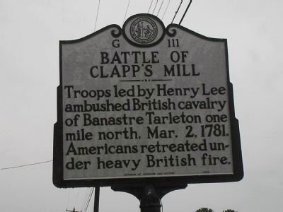
Troops led by Henry Lee ambushed British cavalry of Banastre Tarleton one mile north, Mar. 2, 1781. Americans retreated under heavy British fire. — — Map (db m222722) HM
On Snow Camp Road, 0.2 miles south of Greensboro-Chapel Hill Road.
Settled by Quakers in 1749. Cornwallis camped in area after Battle of Guilford Courthouse and used home of Simon Dixon as headquarters. — — Map (db m223102) HM
On East Penn Street, 0.1 miles north of Blakeslee Boulevard, on the left when traveling north.
Gnadenhuetten. The Moravian mission of this name was built in 1746 to accommodate the growing number of Mohican and Delaware Indian converts. It was the first white settlement in present-day Carbon County. It was burned on November 24, 1755, during . . . — — Map (db m133878) HM
On Flandreau Park Road, 0.3 miles north of 230th Street, on the right when traveling north.
One of the captives of the Spirit Lake Massacre, who was drowned while crossing the Big Sioux River, in April 1857, about 300 yards east of this point. — — Map (db m181285) HM
Near Park Drive (State Highway 92 Spur) 0.3 miles west of U.S. 77, on the right when traveling west.
In September 1848, the remains of Texans killed in the 1842 Dawson Massacre and the 1843 “Black Bean Death Lottery” were reburied at this site in a sandstone vault. The Kreische family did its best to care for the grave during their . . . — — Map (db m53218) HM
On Lee Highway (U.S. 211/340) 0.1 miles east of Kauffman's Mill Road, on the right when traveling west.
A Pioneer and Christian father, who with his wife and six of his thirteen children, was a victim of the last Indian massacre in Page County. — — Map (db m174314) HM
On Houfnaggle Road (County Route 35) 1.8 miles south of Midland Trails Road (U.S. 60), on the left when traveling north.
Pontiac's WarMassacre of white families of Muddy Creek and of the Clendenins near here by a band of Shawnee Indians led by Chief Cornstalk, in 1763, completed the destruction of the early settlements in the Greenbrier Valley.
Welsh . . . — — Map (db m50395) HM
On Warburton Avenue at Broadway (U.S. 9), on the right when traveling south on Warburton Avenue.
"These are the times that try men's souls" —Thomas Paine, American Crisis
On September 30, 1778, near this very spot, 350 Continental soldiers successfully attacked a column of 100 British-allied Hessian . . . — — Map (db m237828) HM
On County Highway 44 at County Highway 61.5, on the right when traveling west on County Highway 44.
History often neglects or omits the 1913-1914 Colorado coalfield strike and massacre
Looking onto this prairie, you see one of several places where coal miners lived during the strike.
Miners demanded better wages, an eight-hour work . . . — — Map (db m193668) HM
Near Greenmanville Avenue (Connecticut Route 27) north of Hinckley Street, on the left when traveling north.
Located in Pequot territory and used for millennia by Indigenous people, it was later colonized by Europeans who displaced local Indigenous peoples. Mystic is also the notorious site of one the most brutal massacres of Indigenous people in . . . — — Map (db m227055) HM
On Pennsylvania Avenue at Katherine Dunham Place, on the right when traveling east on Pennsylvania Avenue.
Here stood the home of Malbern Stephens, a decent man who fought corruption. He was elected mayor after the riot and oversaw reparations to the victims. — — Map (db m142346) HM
On North 9th Street just south of Pennsylvania Avenue, on the right when traveling west.
Marcus Garvey blamed the massacre on Mayor Fred Mollman, who lived at this site. The mayor was incompetent and was indicted for not doing his duty. — — Map (db m142460) HM
On Oak Orchard Road, 0.2 miles west of Henry Clay Boulevard, on the left when traveling west.
Oak Orchard Sacred area for natives Haudenosaunee gathering, fishing and fording place. Site of massacre of Haudenosaunee people. — — Map (db m83896) HM
Near Avenida 3, Paseo de las Damas close to Calle 19.
Miguel Hidalgo 1753-1811 Padre de la Independencia Mexicana del pueblo de Mexico al pueblo de Costa Rica Gustavo Diaz Ordaz Presidente Constitucional de los Estados Unidos Mexicanos 1966 English translation: Miguel . . . — — Map (db m92454) HM WM
On De la Balme Road at East Old Trail Road, on the right when traveling north on De la Balme Road.
[Front Side of Marker];
With recommendation from Benjamin Franklin, Augustin de La Balme, former French Cavalry officer, came to America to assist in the American Revolution.
In November 1780, allegedly under secret orders from . . . — — Map (db m52817) HM
On Monument Square at Monument Ave. on Monument Square.
Neighborhood of Revolution “Paul Revere . . . started on a ride which, in a way has never ended.” - Esther Forbes, author of the classic study, Paul Revere and the World He Lived In In the course of just two pivotal days – April 18 and . . . — — Map (db m191830) HM
On Devonshire Street at State Street, on the left when traveling north on Devonshire Street.
Neighborhood of Revolution “Paul Revere . . . started on a ride which, in a way has never ended.” - Esther Forbes, author of the classic study, Paul Revere and the World He Lived In In the course of just two pivotal days – April 18 and . . . — — Map (db m191828) HM
On Red Oak Drive at Rivervale Road, on the right when traveling east on Red Oak Drive.
In September 1778, British commanders sent huge foraging parties up both sides of the Hudson River, stripping the local farms of their autumn harvest and livestock. Washington’s forces in the area were seriously outnumbered, but he sent small . . . — — Map (db m8456) HM
Near Old Cedar Bridge Road, on the left when traveling west.
On December 27, 1782, Captain Richard Shreve of Burlington County Light Horse and Captain Edward Thomas of the Mansfield militia stopped with their men to refresh themselves at a nearby tavern. They had been searching for the notorious Captain John . . . — — Map (db m139205) HM
Near Mt. McGregor Road, on the right when traveling north.
Mt. McGregor developed as a resort after a road and a small hotel (now Grant Cottage) were built by Duncan McGregor in the 1870s. A group of investors recognized the site’s potential and, in 1882, built a railroad line here from Saratoga Springs. . . . — — Map (db m56921) HM
On Calhoun Drive, on the right when traveling south.
This tree is planted as a living
memorial to the faculty and students who
lost their lives in the April 16, 2007
tragedy at Virginia Tech. — — Map (db m20565) HM
On Jefferson Davis Highway (U.S. 1) at Marina Drive, on the right when traveling north on Jefferson Davis Highway.
Vanished now but for a trace, Falling Creek is the site of the first industrial ironworks in the New World. The close proximity of iron ore, wood for fuel and power provided by the falling water made the Falling Creek site perfect for this . . . — — Map (db m32587) HM
On Lee Highway (U.S. 11) 2.2 miles north of Interstate 81, on the right when traveling north.
John Draper's wife, Bettie Robertson Draper, was captured by Shawnee at Draper's Meadow (Blacksburg) in 1755. Mrs. Draper was carried into the Ohio country along with her sister-in-law Mary Draper Ingles and five others. Six years later John Draper . . . — — Map (db m216193) HM
On Kane Street (Business U.S. 58) east of Jones Street, on the left when traveling west.
About two miles east of Moccasin Gap,
Elisha
Faris (Ferris) in 1787 obtained 116 acres on
both sides of the Moccasin Creek. He and his
family settled in the area about 1782 and
their home became a stop on the Wilderness
Road. On 26 Aug. 1791, . . . — — Map (db m90926) HM
Near County Highway W east of Chief White Antelope Way.
Sacred Memory
Sand Creek is a place where culture and history are at the
center of controversy, trauma, anger, and forgiveness. A
place to reflect on the past as well as the future, the Sand
Creek Massacre teaches powerful . . . — — Map (db m181063) HM WM
Near 3rd Avenue Southwest east of Oak Street South, on the right when traveling east.
This Monument is Erected by the
State of Minnesota,
in Memory of
Anders Petter Lundborg,
born Mar. 23, 1837.
Gustof Lundborg, born Apr. 30, 1839.
Lars Lundborg, born Dec. 22, . . . — — Map (db m78140) HM WM
Near 4th Street (U.S. 287) west of 7th Avenue, on the right when traveling west.
Sand Creek Massacre
At dawn on the morning of November 29 I was still in bed when I heard shouts and the noise of people running about the camp. I jumped up and ran out of my lodge. From down the creek a large body of troops was . . . — — Map (db m107245) HM
On Clarence Street, on the right when traveling north.
The London Women's Monument was dedicated on December 6, 1994. The 5th anniversary of the Montreal Massacre. It is a place to remember and reflect on violence, particularly violence against women, and all women and men who work to end it. — — Map (db m18932) HM
Ellos no han muerto
Estan con nosotros,
Con ustedes y
Con la
Humanidad entera
El Mozote, 11 de dic. de 1991 English translation:
They have not died
They are with us,
With you and
With Humanity
El . . . — — Map (db m83151) WM
On Paseo General Escalón, on the left when traveling west.
Universidad Alberto Masferrer símbol y lema: Tres decadas formando ganadores
La junta central de directores de la Universidad Salvadoreña Alberto Masferrer USAM
En conmemoración del trigésimo aniversario de su fundación, y con la . . . — — Map (db m71225) HM
On Calle Principal, on the left when traveling west.
Alberto Masferrer Humanista insigne y maestro meritísimo Homenaje de la Facultad de Humanidades en el centenario de su nacimiento 1968 English translation: Alberto Masferrer Distinguished humanist and the best of . . . — — Map (db m95208) HM
On Highway Chm. 2, on the left when traveling south.
Coordinador Nacional de Viudas de Guatemala “Conavigua” “Las osamentas y la historia de la verdad” “En memoria a nuestros niños, niñas, mujeres y hombres quienes fueron victimas del genocidio y la represión . . . — — Map (db m101213) WM
On 7a Avenida just north of 8a Calle, on the right when traveling north.
Es nuestro deseo erigir este símbolo para dignificar los centenares de mujeres, niños, y hombres que sufrieron los estragos y el horror de la violencia política durante treinta y seis años desde 1960 a 1996. Los nombres aquí grabados . . . — — Map (db m105317) WM
On Alarcón de Ocaña at Nicolás Romero, on the right when traveling south on Alarcón de Ocaña.
En esta casa nacio el 1º de julio de 1906, el Lic. y Gral. Alfonso Corona del Rosal Hijo predilecto de Ixmiquilpan julio 7 de 1984:
English translation: In this house was born on July 1, 1906, General Alfonso Corona . . . — — Map (db m171221) HM
On Droga krajowa 28 just west of Walerego Waygarta, on the right when traveling west.
Pamięci zesłańców sybiru
Ofiar carskich represji okresu zaborow oraz
sowieckich deportacji
z lat 1939-1956
“Zsyłka na sybir historie polski
pisano lat ponad dwiescie; moze u schyłku tego . . . — — Map (db m199620) WM
On Second Avenue East (US Highway 231) at 4th Street North, on the right when traveling west on Second Avenue East (US Highway 231).
Created Feb. 7, 1818 by Alabama Territorial Legislature from lands ceded by the Creek Indian Nation. Named for the Tennessee Governor W. G. Blount, who sent militia under Andrew Jackson to punish the Creeks for Fort Mims massacre. Jackson fought and . . . — — Map (db m24353) HM
On U.S. 431, 2 miles north of State Route 144, on the right when traveling south.
Gen. John Coffee, commanding 900 Tennessee Volunteers, surrounded Indians nearby; killed some 200 warriors. This was first American victory. It avenged earlier massacre of 517 at Ft. Mims by Indians. — — Map (db m27610) HM
On Barber Street, 0.1 miles north of East 26th Street, on the right when traveling north.
Frank Moore, a WWI veteran buried at Little Rock National Cemetery in 1932, moved to Phillips County, Arkansas, after being honorably discharged in December of 1918 from service as a private in the 162nd Depot Brigade, There he worked on a farm and . . . — — Map (db m210364) HM
On Hanford Street (State Highway 49), on the right when traveling south.
Rich placer mining, 1850’s. Origin of town’s name: Lack of water in nearby creek to wash gold. Many Chinese laborers in fields & mines. East gateway to New Chicago, New Philadelphia, Amador City; Quartz mines: Fremont-Gover & Treasure (1867), Bunker . . . — — Map (db m74124) HM
On Old Alturas Highway (County Route 114) 1.1 miles north of County Route 101, on the left when traveling north.
"Over divide to Tule Lake, on Lost River, passed in sight of Bloody Point where a train of emigrants were cut off last year. This afternoon Geo. W. Ebey killed a brant on the lake. Oh, so good to eat." - James Henry Bascomb Royal, Oct 19, 1853. — — Map (db m147563) HM
On McArthur Road (State Highway 299), on the left when traveling east.
Established by Samuel Lockhart in 1856 as a link in the first wagon road from Yreka to Red Bluff, the Lockhart Ferry crossed below the confluence of the Fall and Pitt Rivers near this spot. After a massacre in December 1856, the ferry was . . . — — Map (db m10292) HM
(West side):
Colorado Territory - Organized
February 28, 1861
Colorado Admitted as a State
August 1, 1876
Census of Territory in 1861 - 23,331
War Governors
William Gilpin
Richard Ed Whitsitt Adjutant General
1861-1862
John . . . — — Map (db m4745) HM
Erected by Pioneer Women of Colorado 1939 A.D. in memory of pioneers massacred by Indians. 1864 A.D. Hungate, Nathan W. and Ellen and Children Laura V., Florence V. 1868 A.D. Dietemann, Henrietta and son John, Louis Alma, Joseph Bledsoe — — Map (db m45748) HM
Near County Highway W just east of Chief White Antelope Way.
"Many years have passed. The land is still here. We lived here, our clans lived here. The land here is our home - we have come back home."
Arapaho:
Wonoo3ei’i ceciniihi’ coowoo’ou’u. Nih’iine’etiino’ hiitiino. Neito’eininoo . . . — — Map (db m180924) HM WM
On West 1st Street (U.S. 34) at Custer Avenue, on the left when traveling west on West 1st Street.
1865 Indian War In November 1864, in southeastern Colorado, U.S. Volunteer troops attacked Black Kettle's peaceful band of Cheyenne Indians at Sand Creek. In retaliation for the massacre and mutilation of 163 Cheyenne men, women, and children, . . . — — Map (db m199956) HM
Near Park Avenue at Monument Street, on the left when traveling west.
On this spot Col. William Ledyard fell by his own sword in the hands of a British officer to whom he had surrendered in the massacre of Fort Griswold, Sept. 6, 1781. — — Map (db m18048) HM
On Monument Street at Park Avenue, on the left when traveling south on Monument Street.
The monument was erected under the patronage of the State of Connecticut, A. D. 1830, and in the 55th year of the Independence of the U. S. A. in memory of the brave Patriots, who fell in the Massacre at Fort Griswold, near this spot, on the 6th of . . . — — Map (db m18050) HM
On Thames Street at Latham Street, on the right when traveling north on Thames Street.
Shelter afforded our wounded and dying soldiers within this house after the massacre at Ft. Griswold Sept. 6, 1781 Moved in 1971 to Ft. Griswold State Battlefield Park — — Map (db m19050) HM
On Marion Street (SR 47) (U.S. 441) at NW Orange Street, on the right when traveling north on Marion Street (SR 47).
Originally called Alpata Telophka, or Alligator Town, this site was a Seminole village, ruled by the powerful chief Alligator, an instigator of the Dade Massacre, which began the great Seminole War of 1835. Following the cessation of hostilities, a . . . — — Map (db m57686) HM
On U.S. 98, 0.1 miles north of County Road 721, on the right when traveling north.
Col. Zachary Taylor had Fort Basinger built in 1837, during the Seminole Wars, on the Kissimmee River 17 miles above its mouth. It was a small stockade which served as a temporary fort and supply station on the line of forts extending from Tampa to . . . — — Map (db m54083) HM
On East Fort King Street at Southeast 39th Terrace, on the right when traveling west on East Fort King Street.
On a nearby knoll stood Fort King, important military outpost during the removal of the Florida Indians. Adjacent to a Seminole agency established in 1825, it was named for Col. William King and first occupied in 1827. Outside the stockade, on . . . — — Map (db m150855) HM
On Ocean Drive south of 8th Street, on the right when traveling south.
This is the actual staircase that was used in the filming of the “1983” classic movie “Scarface” Starring: Al Pacino, Steven Bauer, Mary Elizabeth Mastrantonio and Michelle Pfeiffer. This scene depicts the chainsaw . . . — — Map (db m134441) HM
On U.S. 98/301 at Bluegrass Road, on the right when traveling north on U.S. 98/301. Reported missing.
Construction on Fort King Road, first known as the Military Road, was begun in 1825 north from Fort Brooke at Tampa Bay. By the 1830’s penetration had been made to Fort King near present-day Ocala, and the road assumed strategic military importance. . . . — — Map (db m129360) HM
Near Phillipe Park Drive east of Philippe Parkway, on the left when traveling south.
Menendez, Spanish Governor of Florida, after building fort at St. Augustine (1565) came to this site in 1567 and persuaded the Indian Chief Tocobago and his 1500 braves who lived here, to accept Christianity. Menendez erected a blockhouse for a . . . — — Map (db m46671) HM
On Camp Mack Road at Rosalie Boulevard, on the right when traveling east on Camp Mack Road. Reported permanently removed.
A few miles east of here, on the banks of the Kissimmee River stood Fort Gardiner. Named for Captain George Washington Gardiner who died in the Dade Massacre in 1835. Established December 2, 1837 by Colonel Zachary Taylor on his march to the Battle . . . — — Map (db m212853) HM
On Burns Avenue (State Road 17) at Tower Boulevard, on the right when traveling east on Burns Avenue. Reported permanently removed.
On Kissimmee River sixteen miles northeast of Lake Wales government trail leading to fort crosses highway between Gum Lakes. Lake Rosalee, where Seminole Indians stopped before moving to Everglades, is near this trail. — — Map (db m233384) HM
On U.S. 129 at milepost 17 at Wayfare Road (County Route 1), on the right when traveling south on U.S. 129.
Near here, on August 27, 1836, Georgia Militia companies commanded by Col. Henry Blair, Captain Lindsay and Capt. Levi J. Knight, fought a skirmish with Creek Indians and routed them, killing two and taking several prisoners. During this summer the . . . — — Map (db m27036) HM
On West Main Street south of Church Street, on the right when traveling south.
This County, created by Act of the Legislature Jan. 21, 1854, is named for Col. J. W. Fannin who was killed in the massacre at Goliad, Mar. 27, 1836. He had been captured with about 350 Georgia Volunteers under his command while fighting for the . . . — — Map (db m47137) HM
Near North Perry Street (Georgia Route 20) at West Pike Street (U.S. 29), on the left when traveling south.
In memory of
Gwinnett Company of Mounted
Volunteers, under the command
of Capt. Hammond Garmany who
were slain by Creek Indians
9 June 1836 in a Battle at
Shepherd's Plantation in
Stewart County:
Ens. Isaac Lacy
Sgt. James E. . . . — — Map (db m85721) HM WM
Near South 1st Street West near West Center Street.
This monument marks the grave of an immigrant family, father, mother , and five children, massacred on Little Spring Creek one half mile south of this spot, buried in their own wagon box by trappers and immigrants led by George W. Goodheart. — — Map (db m106254) HM
On North 1550th Street north of 1600th Avenue, on the right when traveling north.
Hutsonville was named after the Isaac Hutson family massacred by Indians in 1813 at a spot sixty four rods due east of this marker. Hutson was killed later in a skirmish with the Indians near Fort Harrison, Indiana. — — Map (db m152463) HM
On North 3rd Street at Missouri Avenue, on the left when traveling west on North 3rd Street.
Near this site was the City Hall, police department and fire station. On the night of the massacre, more than 1,000 people sought safety in the municipal buildings. — — Map (db m142338) HM
On Riverview Drive south of East Laughery Creek Road, on the right when traveling south.
Architect William Tinsley of Cincinnati was known throughout the Midwest for his outstanding landscape designs, including Fountain Square in Cincinnati. Riverview Cemetery on the banks of the Ohio is a splendid example of his work. It is reflective . . . — — Map (db m222258) HM
Near Edrington Boulevard, 0.2 miles north of U.S. 31, on the right when traveling north.
This burial site is for the victims of the Pigeon Roost Massacre in 1812 and was originally marked by only a few stones and a large Sassafras tree. This stump monument denotes the area of the original tree — — Map (db m245523) HM
On N. Main Street (State Road 135) 0.3 miles north of Emma Street, on the right when traveling south.
Located 40 rods west of this spot. Est. before 1812. Salem's early settlers are buried here including Brocks, Kemps, Hendersons; also John Zink, a ranger with Col. Dawalt, fatally wounded by Indians after the Pigeon Roost Massacre. — — Map (db m74079) HM
Miami captive at 14; adopted by Little Turtle; appointed chief scout by Wayne in 1793; granted farm near Ft. Wayne by Congress for "valiant and conspicuous service." Died in Ft. Dearborn Massacre. — — Map (db m58108) HM
Near Circle Drive north of Miriam Lane, on the right when traveling north.
This is the site of the famous
"Spirit Lake Massacre,"
a violent conflict in March 1857 that led to the deaths of 36 settlers. Survivor Abbie Gardner (thirteen years old at the time of the massacre) returned to Arnolds Park and purchased the . . . — — Map (db m233751) HM
On Massachusetts Street at 7th Street, on the left when traveling north on Massachusetts Street.
This marks the site of the Free State Hotel erected in 1855 by the New England Emigrant Aid Society. Destroyed by Sheriff Jones and his posse May 21, 1856, and rebuilt by Col. Schaler W. Eldridge. Quantrill and his raiders destroyed Lawrence August . . . — — Map (db m20397) HM
On Washington Street (U.S. 51) at Clay Street (State Highway 58), on the right when traveling south on Washington Street.
For Capt. Paschal Hickman who was massacred by Indians after River Raisin battle, Jan., 1813, one of nine Ky. officers killed in that action for whom counties named. Resided Franklin County, extensive landowner. Originally, Hickman comprised the . . . — — Map (db m36945) HM
On Mountain Life Museum Road at Levi Jackson Road (Kentucky Route 1006), on the left when traveling east on Mountain Life Museum Road.
The McNitt Company, a group of early settlers organized in Virginia for protection on the trip to Kentucky settlements, was camped here on Boone’s Trace. Failing to post a guard they were massacred by Indians on October 3, 1786. The victims were . . . — — Map (db m172968) HM
On Bloomfield Road (U.S. 62) at Brown's Lane (County Route 2230), on the left when traveling north on Bloomfield Road.
Near here is site of Kincheloe's Station. Named for Capt. William Kincheloe, one of the leaders who established station in early 1780s. Later called Polke's Station for Chas. Polke, who claimed the land. Indians made a surprise attack in Sept., . . . — — Map (db m122024) HM
On Broadway Street (U.S. 25) at E. Main Street (U.S. 460), on the right when traveling north on Broadway Street.
Rendezvous of Kentucky Volunteers, Aug. 15, 1812, ordered to relieve Gen. Hull at Detroit. Kentuckians took Frenchtown (Monroe) on Raisin River Jan. 18, 1813. Four days later enemy attacked-killed, massacred, wounded, or captured all but 30. Of 1050 . . . — — Map (db m70577) HM
On Conway Street, on the right when traveling south.
A military commander during King Phillip's War. Capt. Turner was killed near here in a retreat after leading a massacre of Indians fishing at the Great Falls of the Conn. River in Gill on May 19, 1676. — — Map (db m51133) HM
On Millers Falls Road (Massachusetts Route 63) close to Homer Road, on the right when traveling north.
Two hundred and fifty yards eastward are the sites of three large Indian council fires. The Beers Massacre of September 4, 1675, took place in a gorge one-quarter mile to the northeast. — — Map (db m48780) HM
On Lake Shore Drive (State Highway 185) at British Landing Road, on the left when traveling north on Lake Shore Drive.
Here, during the night of July 16-17, 1812, a small force of British regulars and several hundred voyageurs and Indian allies from St. Joseph Island landed. They occupied a height that overlooks Fort Mackinac and demanded its surrender. Lt. . . . — — Map (db m96411) HM
On Riverside Drive, 0.1 miles west of State Street, on the left when traveling west.
This cabin was donated by
Emmet Olson
in 1927 to this park.
Built prior to 1860, the cabin was the home of these Norwegian settlers who underwent the Indian massacre of Aug. 24, 1862, in Belmont Twp. north of Jackson. Sioux raiders . . . — — Map (db m205191) HM
On Bonhomme Avenue just west of South Hanley Road, on the left when traveling west.
On this site stood Attucks School, the School District of Clayton's second school to serve African American children. Named for Crispus Attucks, the first casualty of the Boston Massacre of 1770, the school educated students from kindergarten . . . — — Map (db m244725) HM
On 6th Avenue Bypass, 0.1 miles south of E. Airport Road, on the left when traveling south.
Named Boothill because so many of its occupants went to their deaths with their boots on, this cemetery was the burying ground for Coulson, Yellowstone River town existing from 1877-1885 on the edge of what was to be Billings. Most famous buried . . . — — Map (db m28939) HM
On Locust Island Road at New Street, on the right when traveling east on Locust Island Road.
In memory of those patriots who were massacred by the British in this house March 21, 1778 ---------- Erected by Oak Tree Chapter Daughters of the American Revolution Salem New Jersey 1903 — — Map (db m21591) HM
On State Road 338 at milepost 24.4 at State Road 9, on the left when traveling north on State Road 338.
The infamous Clanton Gang had two crude dugouts here in the 1880s that served as hideouts and a base for wide-ranging outlaw activities, particularly in connection with the Curly Bill Gang’s depredations along the Smugglers’ Trail that passed by . . . — — Map (db m37771) HM
On Kings Highway at Washington Street, on the right when traveling north on Kings Highway.
Organized 1694
Used as a military hospital and prison during the Revolution. The trials of Major John Andre as a spy, and of Joshua Heit Smith for treason, were held here in 1780. — — Map (db m7375) HM
Southwest Corner of Stockade, was twenty-eight feet South, from a point one hundred feet west, of this tablet. A blockhouse or fort, containing the royal flagstaff, stood in this angle of stockade, and was burned on night of massacre, Feb. 8-9, . . . — — Map (db m32410) HM
Near Canada Street (U.S. 9), on the right when traveling north.
This plaque commemorates the memory of those officers, N.C.O.s and men of the 35th Regiment of Foot (now the Royal Sussex Regiment), their wives and families who lost their lives during the defence of Fort William Henry, and the subsequent massacre . . . — — Map (db m9043) HM
On Main Street at Mallarnee Road, on the right when traveling west on Main Street.
This ridge road west from Cadiz through Deersville to the Tuscarawas Valley is known locally as the Moravian Trail. Originally an Indian path, it became an important trail for the frontiersmen. The men who participated in the Gnadenhutten Massacre, . . . — — Map (db m79828) HM
[Text on Front Side of Marker]
F. C. L.
[Text on Right Side of Marker]
George Duncan Forsyth
Lt. Co. B. 100th O. V. I.
Captured at Limestone Station
Sept. 8, 1863.
Shot and Killed
in Libby Prison.
Apr. 12, 1864, . . . — — Map (db m44765) HM
Near South Bierley Avenue, on the right when traveling south.
During the War of 1812, Northwestern Army Commander General William Henry Harrison led troops through northwest Ohio on the way to Detroit and Ft. Malden in Michigan. After the decimation of General James Winchester's division at Frenchtown . . . — — Map (db m20429) HM
On U.S. 81, 0.2 miles south of County Road E0550, on the right when traveling south.
From this noted watering place came the name of "Bison," 1 mi. so., "Buffalo Springs" was the camp site of Pat Hennessey and his men just before they were massacred, 7 mi. so., July 4, 1874. Next day, a war band of Indians was stood off by ranchmen . . . — — Map (db m39801) HM
Near Honey Springs Battlefield Road, 1.4 miles north of East 1020 Road, on the right when traveling north.
Newspapermen, sketch artists, and even photographers reported on the Civil War. Frank Leslie's Illustrated Newspaper was represented at the Battle of Honey Springs by James R. O'Neill, whose sketch and report on the battle appeared in that . . . — — Map (db m243557) HM
On Water Street west of Harrison Street, on the right when traveling east.
Talgayeeta, a Cayuga Indian also known as Chief Logan lived here 1772. Logans sister Koonay married trader John Gibson here. Logans family was massacred by renegade whites at Yellow Creek in 1774. He then wreaked terrible vengeance on white settlers . . . — — Map (db m44880) HM
On Monument Avenue, on the left when traveling west.
This wall reconstructed in 1964 under the supervision of Raymond S. Cox and J. Gilmore Wilson. The wall contains some stones taken from the old foundations of the Ezekial Bowen log cabin which was standing and occupied by some American officers on . . . — — Map (db m16348) HM
On Great Cove Road (U.S. 522) at Rock Hill Road (Local Route 379), on the left when traveling south on Great Cove Road.
Among those buried here are victims of the Great Cove Massacre of Nov. 1, 1755, at present McConnellsburg. The raid was conducted by Delawares and Shawnees led by Shingas, the Delaware "king." Houses were burned, and about 50 settlers were killed . . . — — Map (db m27267) HM
On River Road (Pennsylvania Route 3030) 0.1 miles south of Safe Harbor Road, on the right when traveling south.
The Conestoga Indians lived in scattered settlements along this stream. They were the last of the once mighty Susquehannocks. Their final location was the Conestoga Indian Town which was along the road leading to Creswell. William Penn visited the . . . — — Map (db m160253) HM
On Valley Street at Wyoming Avenue (U.S. 11), on the right when traveling east on Valley Street.
The British battle line was formed almost parallel with and a little north of this street by Major John Butler, the commander, and Sayenqueraghta, chief of the Senecas. After advancing in formation for a mile to about 100 yards south of the British . . . — — Map (db m56393) HM
988 entries matched your criteria. Entries 301 through 400 are listed above. ⊲ Previous 100 — Next 100 ⊳
* Inflectional forms of words are their plurals, singulars, and possessives as well as gramatical tenses and similar variations.