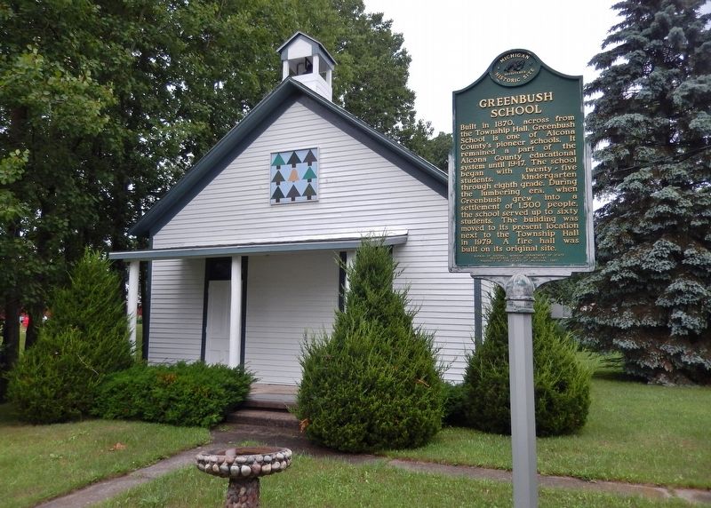
On Campbell Street west of State Street, on the right when traveling west.
Built in 1870, across from the township hall, Greenbush School is one of Alcona County’s pioneer schools. It remained a part of the Alcona County educational system until 1947. The school began with twenty-five students, kindergarten through . . . — — Map (db m121967) HM
On North Lake Street 0.1 miles north of East Main Street, on the left when traveling north.
The first issue of the Alcona County Review was published on April 27, 1877 by publisher James K. Fairchild. Nine publishers and 140 years later, the Review is the oldest continuously run business in Alcona County. Throughout all of . . . — — Map (db m121971) HM
On Point Road east of Sturgeon Trailways Road, on the left when traveling east.
In the mid-1800s the first white settlers came to what is now Alcona County. As the population grew, schools became part of nearly every settlement or logging camp. The first school was built in 1860. In 1869, Alcona County was established but . . . — — Map (db m277850) HM
Near North 5th Street just north of West Jefferson Street, on the right when traveling north.
This bell marks the site of the beloved red brick schoolhouse on the hill. Proud alumni and loyal friends dedicate this memorial to those who taught and learned from morning ring to closing toll. The bell symbolizes love, laughter and learning of . . . — — Map (db m154630) HM
On East Dock Street 0.1 miles east of North Lake Street, on the left when traveling east.
In 1883, Russell Alger formed the Detroit, Bay City and Alpena Railroad. In 1895 it was combined with the Alpena and Northern to form the Detroit and Mackinaw Rail Company. In 1900 depot sites were selected at Greenbush and Harrisville. Scheduled . . . — — Map (db m121975) HM
On East Main Street east of North Lake Street, on the left when traveling east.
In September 1846, fisherman Simeon M. Holden and his boat's crew, Robert McMullen and William Hill, were driven by a northwest gale from their fishing ground at Thunder Bay Island and made land at the High Banks of AuSable, now called Springport. . . . — — Map (db m277372) HM
On West Main Street (Michigan Route 72) at North State Street (U.S. 23), on the right when traveling west on West Main Street.
Erected by the Women's Civic League of Harrisville in memory of our boys who
sacrificed their lives in the Great World War.
Percy Anderson •
John E. Armstrong •
Delbert Atchison •
Harvey G. Alexander •
Asa Baird •
Ernest R. Berry . . . — — Map (db m277399) WM
On Point Road east of Spruce Trailways Road, on the left when traveling east.
This anchor windlass was mounted on the forward deck of large sailing vessels to raise their heavy anchors. It was mounted in a strong frame and used a rachet device to rotate the shaft to lift and recover
the anchors and lines. — — Map (db m277857) HM
On Point Road east of Spruce Trailways Road, on the left when traveling east.
Built in 1907 of Norway pine, the Bailey School is one of the few remaining one-room, log schoolhouses still standing in Michigan. It was built at the site of
the C.A. Johnson Logging Camp west of Mikado for the children of the logging crews, and . . . — — Map (db m277568) HM
Near Point Road east of Sturgeon Trailways Road, on the left when traveling east.
The history of the Great Lakes is dominated by tales of majestic schooners and gigantic freighters battling storms. Working in the shadows of these larger ships, thousands of small workboats tolled in every corner of the Great Lakes. They
were . . . — — Map (db m277671) HM
On Point Road east of Spruce Trailways Road, on the left when traveling east.
(On Left)
The Capstan is an apparatus which
is mounted on thenforedeck of a ship to raise anchors and handle other heavy loads. This one was operated by hand using bars inserted in the holes at the top.
Damage suggests this one failed under . . . — — Map (db m277965) HM
On Point Road east of Spruce Trailways Road, on the left when traveling east.
Get Into Your Sanctuary
Sanctuary Sentinels
As the nation's population and economy rapidly expanded throughout the 19th century, so did the shipping traffic on the Great Lakes. Violent storms, thick fog, shifting sandbars, rocky . . . — — Map (db m277968) HM
Near Point Road near Spruce Trailways Road, on the left when traveling east.
According to the Detroit Tribune, the tug Loretta "was always considered an unlucky boat, having been in dry dock every season since coming out." On the morning of October 7, 1836, the Loretta was awaiting repairs at Black River when a . . . — — Map (db m277860) HM
On Point Road east of Spruce Trailways Road, on the left when traveling east.
On August 29, 1880, the sidewheel passenger vessel Marine City steamed across Lake Huron. While just off Sturgeon Point, passengers and crew noticed smoke
coming from the engine room. In very little time, the fire engulfed the ship. As thick . . . — — Map (db m277836) HM
On Point Road east of Spruce Trailways Road, on the left when traveling east.
After stopping for a load of shingles at Alcona the ship caught fire three miles off shore from Sturgeon Point. The fateful day was Aug. 29, 1880.
The tugs Vulcan and Grayling came to the rescue. Approx. 100 passengers, 41 crewmen leaped into . . . — — Map (db m277845) HM
On Point Road east of Spruce Trailways Road, on the left when traveling east.
This tug caught fire at the dock of the Alger Smith lumber mill in Black River, Mi., circa 1890. It was pushed away from the dock where it sank. — — Map (db m277854) HM
Near Point Road east of Sturgeon Trailways Road, on the left when traveling east.
This is a gasoline powered fishing boat typical of many used on the great lakes in the first half of the 20th century. Fishing for lake trout, white fish and other species was a major industry from the early 19th century until the sea lamprey, an . . . — — Map (db m277606) HM
On Dune Lane near Alcona Road and North Lake Shore Drive.
Circa 1845, William Hill established a fishery at this place,
which was called The Cove. He had five fishing boats and a
lodging house. The settlement became the village of Alcona.
In the 1860s and 1870s, Johnston, Haynes & Company built
a saw . . . — — Map (db m233580) HM
William Hill established a fishing
station in this area. known as "the
Cove." circa 1853. Early residents
were fishermen who netted the once
abundant schools of herring.
whitefish and perch. Johnson, Haynes
and Co. began lumbering the . . . — — Map (db m233566) HM
On Point Road east of Spruce Trailways Road, on the left when traveling east.
This bell was originally mounted in
the Watchtower from which the Coast Guardsmen at Sturgeon Point maintained a dawn-to-dusk lookout for vessels in trouble out on the Lake. If a vessel in distress was spotted the man on duty would ring the bell to . . . — — Map (db m277674) HM
Near West Fletcher Street west of Commercial Street, on the left when traveling north.
Shipbuilding forever changed with the transition from wooden hulls to those built of iron and steel. The first iron-hulled freighter on the Great Lakes, the Onoko, debuted in 1881. At 287 feet long, she was a giant of her day. Just five years . . . — — Map (db m122196) HM
On North First Avenue north of Park Place, on the right when traveling north.
Located on the Government Square, City Hall remains one of Alpena’s most prominent structures. In 1904 when the city council chose to construct the building of Bedford (Indiana) limestone rather than local limestone or concrete from Alpena’s . . . — — Map (db m121900) HM
On West Chisholm Street (U.S. 23) south of South Ninth Street, on the right when traveling south.
"Alpena has blazed a new trail in construction," architect William H. Kuni of Detroit declared at the opening of the Alpena County Courthouse on October 21, 1935. Calling it "the first monolithic building erected in a cold climate," Kuni designed . . . — — Map (db m66795) HM
Near West Fletcher Street west of Commercial Street, on the left when traveling north.
At the time of the U.S. Civil War, thousands of sailing ships worked the Great Lakes. Despite their impressive numbers, these sailing vessels struggled hardly able to keep pace with the enormous demands for bulk cargos generated by America's . . . — — Map (db m122215) HM
Near West Fletcher Street west of Commercial Street, on the left when traveling north.
Launched in 1891, the Grecian symbolizes an era of unprecedented industrial growth and dramatic changes in technology. Newspapers heralded the steamer and her five sister ships as “fast steel flyers.” A marvel of efficiency at . . . — — Map (db m126625) HM
On Lockwood Street at South Second Avenue, on the left when traveling north on Lockwood Street.
Soon after white settlers came to
the area in 1856, J.K. Miller held
religious gatherings at the home
of Daniel and Sarah Carter. These
meetings evolved into the First
Congregational Church, which was
organized on March 2, 1862, with
the . . . — — Map (db m233605) HM
Near West Fletcher Street north of North 2nd Avenue, on the left when traveling north.
In 1874, the 60-foot wooden harbor tug E.H. Miller began a 45-year career operating out of Alpena, escorting vessels on the Thunder Bay River and assisting those in distress. The tug was not without her own share of mishaps. In her first . . . — — Map (db m122200) HM
Near West Fletcher Street west of Cedar Street, on the left when traveling north.
The maritime professionals who sail the ships on the Great Lakes are celebrating the 100th anniversary of their fraternal organization, the I. S. M. A. whose purpose is stated in the Association's constitution, "The purpose of this association's . . . — — Map (db m121889) HM
On West Campbell Street east of West Washington Avenue, on the right when traveling east.
In 1916 the Monarch
Milling Company, a grist
and flour mill, began
operations in this
building, which was
constructed in 1914. By
1920 it was known as the
Alpena Flour Mills,
producing “Leader” and
“Velvo” brand flour. The
mill closed in . . . — — Map (db m233604) HM
Near West Fletcher Street west of Cedar Street, on the left when traveling north.
The screw steamer or "propeller" first appeared on the Great Lakes in the 1840s. These vessels featured wooden hulls and shallow bottoms like early sidewheelers, but their steam engines powered one or more screw propellers at the stern of the ship . . . — — Map (db m121898) HM
Near West Fletcher Street west of Commercial Street, on the left when traveling north.
For centuries explorers and scientists have researched the Great Lakes. As a vital transportation link to the Midwest and one of the largest sources of fresh water on the planet. Such important resources warranted scientific, charting and survey . . . — — Map (db m122199) HM
Near West Fletcher Street west of Commercial Street, on the left when traveling north.
Life on the frontier Great Lakes was dangerous when the sidewheeler Vermilion went into service in 1838. In 1842, the 151-foot steamer burned to the waterline, killing several people. A year later, with immigration booming and the economy . . . — — Map (db m122429) HM
Near West Fletcher Street west of Merchant Street, on the left when traveling north.
Sailing ships first appeared on the Great Lakes when French explorer Rene Robert Cavalier, Sieur de La Salle built the Griffon in 1679. By 1870, over two thousand sailing ships plied the Great Lakes. Most of these sailing ships were . . . — — Map (db m122194) HM
On West Chisholm Street (U.S. 23) south of South 5th Avenue, on the left when traveling north.
In 1861 Bishop Frederic Baraga (1797-1868) trod through snow and icy waters from Sault Ste. Marie to Alpena where he founded a Catholic church. However, it was not until 1866 that Father Patrick Murray became the first resident pastor of the church . . . — — Map (db m121899) HM
Near West Fletcher Street west of Commercial Street, on the left when traveling north.
Steam power first appeared on the Great Lakes in 1818. The earliest "steamers" were expensive to build and operate. Constructed of wood, the vessels had shallow bottoms and were powered by large sidewheels.
For a time, these "sidewheelers" . . . — — Map (db m121957) HM
On Park Place just north of North 1st Avenue, on the right when traveling north.
In 1856 Daniel Carter, who came to
the Thunder Bay region seeking pine
lands, brought his wife, Sarah, and
daughter Mary to the town of Fremont,
present-day Alpena. They were Alpena’s
first permanent settlers. Daniel participated in the . . . — — Map (db m233610) HM
Near West Fletcher Street west of Merchant Street, on the left when traveling north.
In November of 1856, George N. Fletcher assisted a survey crew in laying the footprint for the city of Alpena. Appreciative of the area's dense forest and the Thunder Bay River's ability to help transport raw materials, finished products, and fuel, . . . — — Map (db m122228) HM
Near West Fletcher Street at Cedar Street, on the left when traveling north.
The Civil War created an insatiable demand for copper. At a time when Michigan's Upper Peninsula produced the majority of America's supply, vessels like the Pewabic played a critical role in the war effort. On a typical trip between lakes . . . — — Map (db m121896) HM
Near North 1st Avenue north of Water Street, on the right when traveling north. Reported permanently removed.
Located across the river from where you are standing is an area known historically as Alpena's Third Ward. The first dwellings there were erected in 1858 or '59 at the river's edge, while the majority of the land remained woods and swampland. The . . . — — Map (db m121894) HM
Near North 2nd Avenue north of Water Street, on the right when traveling north. Reported permanently removed.
From the time of Alpena's inception it was divided by the Thunder Bay River, although most of the community was centered on the south side. A wooden scow served as a ferry, connecting Second Avenue on the south side with Dock Street on the north; it . . . — — Map (db m121890) HM
Near West Fletcher Street west of Cedar Street, on the left when traveling north.
The first known fishing camp near Alpena was established on Thunder Bay Island in 1835. By the 1840s, both Thunder Bay Island and nearby Sugar Island served as a base for the area's fishing fleet, comprised entirely of sailing vessels. In 1846, . . . — — Map (db m121897) HM
Near North 7th Avenue north of River Street when traveling north.
From 1858 to 1926, Thunder Bay served as a major center of the Great Lakes lumber trade. Schooners and steamers shipped lumber around the Great Lakes and to eastern cities. Beginning in 1845, Thunder Bay Island also served as a "wooding," or fueling . . . — — Map (db m121895) HM
Near West Fletcher Street west of Merchant Street, on the left when traveling north.
Like other "canallers," the schooner E.B. Allen squeezed through the canals and locks of the Great Lakes. Crews tried to maximize the payload, and thus profits, using every inch of cargo space.
The heavy traffic of thousands of sail and . . . — — Map (db m122198) HM
On North 2nd Avenue north of Water Street, on the right when traveling north.
“By the Treaty of Saginaw, made at Saginaw [Saquina] September 24, 1819, by General Lewis Cass, Governor of the Northwest Territory, on the part of the United States, and the Chippewa Nations, Thunder Bay River became a part of the boundary of the . . . — — Map (db m182328) HM
On Water Street south of North 1st Avenue, on the right when traveling south.
U.S.S. Maine, destroyed in Havana harbor February 15th 1898. This tablet cast from metal recovered from the U.S.S. Maine.
(on the shield) ☆ Patriotism ☆ Devotion ☆
— — Map (db m233608) WM
Near North 1st Avenue north of Water Street when traveling north. Reported permanently removed.
Shipping on the Great Lakes has always been seasonal. The poor visibility, heavy seas and ice that came each year with the gales of November prompted ship owners and captains in the 1800s to "lay up" their ships. Every winter ice choked docks and . . . — — Map (db m121892) HM
On Ford Avenue at Wessel Road, on the right when traveling east on Ford Avenue.
Portland cement, so-called because
it resembles in color stone from
the Isle of Portland, in the British
Isles, was first produced in the
United States in 1871, in Michigan
in 1896. Because of Alpena’s location
in the midst of immense . . . — — Map (db m233611) HM
On East Fletcher Street south of North 2nd Avenue, on the right when traveling south.
Launched in 1891, the steel-hulled Grecian was built during an era of unprecedented
industrial growth and dramatic change in shipbuilding technology. Good steel flexes
but doesn’t break upon impact. However in June 1908, when the . . . — — Map (db m236369) HM
On East Fletcher Street south of North 2nd Avenue, on the right when traveling south.
Built for speed, the 236-foot steam package freighter Montana
initially carried all types of freight. A typical trip found the
Montana carrying a diverse cargo of 6,000 barrels of flour, 40
tons of copper, 250,000 shingles, 100 . . . — — Map (db m236026) HM
On East Fletcher Street near Ford Avenue, on the right when traveling south.
On Saturday night, November 19, 1966, the Nordmeer was traveling to
Chicago from Hamburg, Germany, with a cargo of 990 coils of steel
destined for Milwaukee. It was the ocean-going vessel’s first freshwater
voyage. The night was clear. . . . — — Map (db m236019) HM
On East Fletcher Street south of North 2nd Avenue, on the right when traveling south.
My name is Abby O’Bryan, I am a Girl Scout with Troop 1033 in Alpena.
I proposed the original idea of a dog park to a member of the City Council and
began the planning process. During the initial stages, I met many others with
common interests . . . — — Map (db m236519) HM
On East Fletcher Street south of North 2nd Avenue, on the right when traveling south.
Thomas Stafford was born in Wexford, Ireland in 1842. After originally immigrating to Canada,
Stafford moved to Alpena where he married Elizabeth McDougall. The couple raised nine children
in Alpena, with many descendants still living in the area . . . — — Map (db m236518) HM
On East Fletcher Street at Ford Avenue, on the right when traveling south on East Fletcher Street.
Shipwreck Alley.
For more than 12,000 years, people have traveled on the Great Lakes. From Native American dugout canoes to wooden sailing craft and steel freighters, thousands of ships have made millions of voyages on the Inland Seas. The . . . — — Map (db m236835) HM
On East Fletcher Street at Ford Avenue, on the right when traveling east on East Fletcher Street.
What is this
NOAA
building?
This building houses
equipment that records Lake
Huron water levels, wind
speed and direction, air and
water temperature,
barometric pressure, and
relative humidity. It was
installed in 2006.
NOAA’s . . . — — Map (db m235924) HM
On Alpena Bi-Path near Water Street and North 2nd Avenue, on the left when traveling south.
Since Alpena’s inception, the Thunder Bay River has bisected the city. Initially, a wooden
scow, pulled back and forth across the river with a rope, served as a ferry and connected
Second Avenue on the south side with Dock Street on the north. In . . . — — Map (db m235868) HM
Located across the river from where you are standing is an area
known historically as Alpena’s Third Ward. The first dwellings
were erected in 1858 or ’59 at the river’s edge, while the majority
of the land remained woods and swampland. In 1867, . . . — — Map (db m235736) HM
On Alpena Bi-Path just north of the end of North 1st Avenue, on the right when traveling east.
Shipping on the Great Lakes has always been seasonal. Poor
visibility, heavy seas and ice that arrive each year with the gales
of November prompted 19th-century ship owners and captains
to “lay up” their ships and take them out of active service . . . — — Map (db m235671) HM
On South 2nd Avenue (Michigan Route 32) near Lockwood Street, on the right when traveling east.
E. P. Austin • Vincent Agius, Jr. • Philip B Emerson • Jack R. Sanborn • David K. Bruning • Ned A. Heath • Rodney Chapman • Gene P. Fussey • Phillip A. Elliott • Bruce E. Hahn • Thomas P. Smith • Donald J. Woloszyk • Frederick J. Wozniak • Luther A. . . . — — Map (db m235658) WM
On Alpena Bi-Path (Michigan Route 32) west of South 11th Avenue and West Campbell Street, on the right when traveling west.
This sculpture series represents the history of industry in Alpena and the surrounding region of Northeast Michigan. It is dedicated to
the people who made livelihoods for themselves, their families and their communities throughout time.
While . . . — — Map (db m235657) HM
On Leer Road at Carr Road, on the right when traveling south on Leer Road.
In the summer of 1879
five Norwegian families
settled what became the
village of Leer. They and
those who followed came
to Michigan seeking to
own their own land. Many
of the men worked in area
lumber camps and Alpena’s
mills until they . . . — — Map (db m233696) HM
On U.S. 23 at E. Nicholson Hill Road, on the left when traveling north on U.S. 23.
In Memory Of
Bruce E Hahn
Sgt E5 U.S. Army
Vietnam
July 13th 1948 - May 6th 1970
In Memory Of
Roger P. Briunski
Sgt E5 U.S. Army
Persian Gulf
April 30th 1966 - Feb. 27th 1991 — — Map (db m165334) WM
This Memorial is Dedicated
to the Men and Women
Who Served Their Country,
State, and Community
With Courage, Dedication,
and Sacrifice
in War and in Peace.
They Will Not Be Forgotten. — — Map (db m190677) WM
In 1891-92 the Chicago and West Michigan Railway, precursor to the
Pere Marquette Railroad, extended the line between Traverse City and
Petoskey through Spencer Creek. William Alden Smith, the railway's
general counsel, advocated building the . . . — — Map (db m190676) HM
On Bridge Street at Broad Street, on the right when traveling north on Bridge Street.
This building began life in 1881 as a print shop and offices for Bellaire's first newspaper, The Bellaire Breeze, run by Albert S. Abbott. It's the oldest standing building in the Bridge Street business area. Alice Jane White was born in Ionia . . . — — Map (db m284962) HM
On Bridge Street at Broad Street, on the right when traveling north on Bridge Street.
In 1883, the Kearney Township Hall was built here on land purchased for $100. Township offices were on the first floor. The second floor was the Opera House with space for dances, travelling shows, and other community activities. The Antrim . . . — — Map (db m284957) HM
On Bridge Street south of Broad Street, on the right when traveling south.
This block of buildings that now houses Short's Brewery is on the
site of the former Bellaire House Hotel. The hotel was enlarged to meet
the needs of the new county seat and sold in 1901 to Ira Adams.
Adams already had a small general store . . . — — Map (db m284950) HM
On Broad Street east of Bridge Street, on the left when traveling east.
Antrim County sheriff Henry Stewart built a small barn here in 1887. It became a livery business, and George Stanley, who acquired it in 1900,
made many improvements. In 1906, Edward Maltby took possession, and it became the most important . . . — — Map (db m284959) HM
On Park Street south of Antrim Street, on the right when traveling south.
Born in 1850, William J. Nixon was raised in southern Michigan. In the 1870s, he moved to Antrim County and partnered in a grocery store with his brother, Allen, becoming sole owner when Allen moved away. He married Emma Richardi in 1883. She . . . — — Map (db m284951) HM
On Park Street south of Antrim Street, on the left when traveling south.
This property was home to the 1st Congregational Church of Bellaire from the 1880s until it disbanded in the early 1920s. In 1922, Harley Smith bought it and built a barn. In 1932, after drilling test wells in several places in town, the village . . . — — Map (db m284953) HM
On Broad Street east of Bridge Street, on the left when traveling east.
As the new county seat, the Antrim County Board of Supervisors recognized in 1879 that Bellaire needed a jail and a sheriff's house. They were completed in 1881 at a cost of $5000. The sheriff lived in front and the jail was attached behind. . . . — — Map (db m284960) HM
On Bridge Street at Broad Street, on the right when traveling north on Bridge Street.
In Honor of
the Men and Women of Bellaire
who Served in World War II
and
In Memory of
Those who made the Supreme Sacrifice
Girdon Grannis • Leon Rauch
Cleveland Patton • Walter Watrous — — Map (db m284955) WM
On East Cayuga Street (Michigan Route 88) east of North Bridge Street (Route 88), on the left when traveling east.
The first pioneers of Antrim County
settled along Grand Traverse Bay
near Elk Rapids in the 1850s. Later
settlers moved inland, and urged
that the county seat be transferred
from the bay shore closer to the
geographical center of the . . . — — Map (db m234153) HM
On US-Route 31 (U.S. 31) 0.2 miles north of 1st Street, on the right when traveling north.
Before America was discovered, indigenous people hunted and fished the Grand Traverse region for thousands of years. As far back as 8,000 B.C., the waters of Grand Traverse Bay, Elk River and the 14 lakes of Antrim County's Chain of Lakes had been . . . — — Map (db m98175) HM
In this photo you are standing on the other side of the Elk River and to the left side of the photograph. This picture of Elk Rapids is from the 1890s and the view is from the top of the Elk Rapids Iron Company's Furnace. What is left of this . . . — — Map (db m98173) HM
In 1856 Dexter and Noble Company began building an empire with their sawmill and mercantile business. In 1872 they built an iron smelting plant, one of the largest charcoal furnaces in the country. At each step of their building that empire, . . . — — Map (db m98125) HM
On Ames Street north of Bass and Ojibwa Streets, on the right when traveling north.
Elk Rapids thrived in the late
nineteenth century due to the
lumber industry boom and local
iron and chemical manufacturing
plants. When the economy declined,
people left to find work. Between
1910 and 1920. the town lost two-thirds of its . . . — — Map (db m234256) HM
On Ames Street west of U.S. 31, on the right when traveling west.
The brick ruin near this marker was
the hearth of the Elk Rapids furnace,
during the 1870s one of the nation's
greatest producers of charcoal iron.
Forty-seven feet high and twelve
feet in diameter, it was begun in
1872 and produced the first . . . — — Map (db m257300) HM
As shown in the above photograph taken in c1910, the Elk River and Chain of Lakes provided a means of transporting logs to the Dexter & Noble sawmill and a shoreline site where cord wood was made into charcoal fuel for the iron furnace. This . . . — — Map (db m98151) HM
On Traverse Street at Pine Street, on the left when traveling west on Traverse Street.
In the late 1850s traveling pastors
began to conduct Methodist services in
Elk Rapids and nearby communities.
First Methodist Episcopal Church was
organized in the early 1870s. Services
were held in a former school and then a
former . . . — — Map (db m234753) HM
Native Americans have hunted and fished the Grand Traverse region for thousands of years, perhaps as many as 10,000 years before white settlers appeared. The waters of the Bay, Elk River and the 14 lakes of Antrim County's Chain of Lakes had been . . . — — Map (db m98128) HM
On US Route 31 (U.S. 31) 0.2 miles north of 1st Street, on the right when traveling north.
US 31 in its present location was built in 1953. In the 1960s, the Rotary Club of Elk Rapids began to develop the land between the highway and Elk River. With the help of other local organizations, the area became a park, named Rotary Park in . . . — — Map (db m98118) HM
On River Street west of Ash Street, on the right when traveling west.
Look carefully westward to see what remains of the Elk Rapids City Dock. This dock was one of
three docks situated within the village limits. It served the community of Elk Rapids from 1905
to 1911. The pier extended 1,440 feet out into East Grand . . . — — Map (db m247432) HM
On Ames Street west of U.S. 31, on the right when traveling east.
The Elk Rapids Iron Company began operations at this location in 1873. You are standing in front of the base of the smelting furnace. The tall rectangular
elevator tower was used to dump iron ore, limestone and charcoal into this furnace. . . . — — Map (db m257299) HM
On River Street at Pine Street, on the right when traveling west on River Street.
Edwin S. Noble (1838-1922) designed
and built this house for his family in
1865. Noble, an expert accountant,
was associated with the Dexter Noble
Company, first as secretary-treasurer
and later as a full partner. The company
was involved in . . . — — Map (db m234603) HM
On Dexter Street at U.S. 31, on the left when traveling west on Dexter Street.
Native Americans first came to this area to plant their gardens. Immigrants from many countries were drawn to the Antrim Chain of Lakes
primarily to harvest the vast stands of hardwood growing nearby. The Elk Rapids Iron Company was built on the . . . — — Map (db m257306) HM
On River Street west of Pine Street, on the right when traveling west.
Memorial to those who gave their lives in the service of their country.
World War II. John Bachi • Robert Barnes • Donald Banninger • Byron Hassett • Lynn Hansen • Willard Banninger • Ralph Hirt • Mark Mamagona • Wayne Martinek • William . . . — — Map (db m247405) WM
On River Street at Spruce Street, on the left when traveling west on River Street.
Designed by Charles H.Peale
and built in 1883 near the
site where the earliest
white settler, Abram Wadsworth had lived, the Elk
Rapids Township Hall has
served as a social and
political center
center for over
ninety years. Largely due
to . . . — — Map (db m234752) HM
It has often been asked, "Why the stumps in the river?"
In a way, the stumps tell the story of Elk Rapids. In the beginning the trees grew there while the land was still dry. As one can see in the photograph of the blast furnace, which was . . . — — Map (db m98135) HM
On Essex Road at South Dennis Road, on the right when traveling east on Essex Road.
At the beginning of 1901, a
reporter visiting Essex noted thirty to forty houses, a
large sawmill. a stave factory, a shingle mill, one store,
a telephone office, a blacksmith shop, a livery stable
and a post office. A 1902
Central Lake Torch . . . — — Map (db m234152) HM
On U.S. 131 at Satherly Lake Road, on the left when traveling north on U.S. 131.
On November 10, 1881, the Antrim County Herald ran an advertisement about the village of Wetzell that read: "New Town, New Store; Everything New!" Earlier that year the Wetzell brothers had platted the village and opened a sawmill. As the . . . — — Map (db m215768) HM
On Saint Johns Road at Route 32, on the left when traveling south on Saint Johns Road.
n 1885 Bohemian immigrants founded Saint John
Nepomucene Catholic Church,
named for the patron saint of
Czechoslovakia. The settlers,
most of whom emigrated from
Prague, named their community Praga. This Gothic
Revival church was built as
a . . . — — Map (db m234149) HM
On Michigan Avenue (U.S. 31) north of Traverse Avenue, on the left when traveling north.
In 1858, in what was then a remote wilderness, the Rev. Charles E. Bailey and four families from his Ohio Congregational parish founded Benzonia colony. It was to be an "educational Christian colony" modeled after the earlier Congregational . . . — — Map (db m97478) HM
On Michigan Avenue (U.S. 31) north of Traverse Avenue, on the right when traveling north.
Historian, author, editor, Bruce Catton (1899-1978) is best known for his two Civil War trilogies -- The Army of the Potomac and The Centennial History of the Civil War. Born in Petoskey, Catton spent most of his childhood in Benzonia, . . . — — Map (db m97480) HM
On Michigan Avenue (U.S. 31) north of Traverse Avenue, on the right when traveling north.
This building was a girls dormitory erected in 1909 for the Benzonia Academy. Named Mills Cottage in honor of the Reverend Harlow S. Mills, pastor of Benzonia Congregational Church from 1896 to 1916, it became property of that church when the . . . — — Map (db m97479) HM
On Michigan Avenue (U.S. 31) at Traverse Avenue, on the right when traveling south on Michigan Avenue.
Dedicated to the memory of the pioneers, who, in 1858, came to this region, then an unbroken forest, to establish a Christian community and college. Here they founded the earliest institution of higher learning in northern Michigan which was a . . . — — Map (db m228944) HM
On Benzie Highway (U.S. 31) south of King Road, on the right when traveling south.
William Davis. the son of
a plantation owner and a
slave woman, came here
with his wife. Mildred
Brand, and their children
in 1863. They were among
the area's first black
landowners. Upon the
death of his daughter in
1870, William Davis . . . — — Map (db m192394) HM
On Prospect Avenue at Lake Street, on the left when traveling west on Prospect Avenue.
In 1873 an ambitious but ill-advised project was put through in an effort to connect Crystal Lake and Lake Michigan with a navigable channel. The original level of Crystal Lake was, at that time, much higher than its present level. The project was a . . . — — Map (db m97481) HM
On Forest Avenue at 5th Street, on the right when traveling west on Forest Avenue.
On January 26, 1868, twenty-three early Frankfort residents founded First Congregational Church of Frankfort. They received guidance from an established Congregational Church in Benzonia, Michigan. In accordance with the practices of . . . — — Map (db m168222) HM
811 entries matched your criteria. The first 100 are listed above. Next 100 ⊳