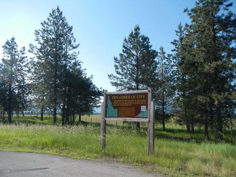
On Smylie Boulevard (State Highway 54 at milepost 8) near East Howard Road, on the right when traveling east.
A gold rush to Montana brought steamboat service to lake Pen d'Oreille in 1866, with its dock at Pen d'Oreille City 5 miles east of here on Buttonhook Bay.
Traffic to British Columbia's Wild Horse mines also used this route. The trip . . . — — Map (db m122152) HM
On Smylie Boulevard (State Highway 54 at milepost 15) near Locust Grove Road, on the left when traveling east.
Large kilns that produced line from 1904 to 1932 still can be seen by visiting Bayview, two miles from here.
Production of lime for nearby mines and Spokane buildings commenced in this area as soon as rail transportation and markets . . . — — Map (db m122170) HM
On Smylie Boulevard (State Highway 54 at milepost 12) near North Perimeter Road, on the right when traveling east.
In 1942, a large United States Naval training station, with facilities for 40,000 sailors, opened here. Then, from 1946 to 1949, it became Farragut College.
When postwar college enrollments slacked off, Farragut State Park was developed here, . . . — — Map (db m122155) HM
Once the grounds of a naval hospital, this area of park is now home to four disc golf courses.
In 1942, the US Government acquired this land to build a navy training station. Over the next four years 293,381 men went through their boot training . . . — — Map (db m122172) HM
This type of canoe was not used by the Coeur d'Alene until the arrival (of the) pioneer settlers. Combined with iron tooling and burning, it took two men up to eight weeks to build. The Indians preferred their traditional bark-skinned canoe . . . — — Map (db m122768) HM
The horse-powered grist mill is shown with a half-timbered frame. Brother "blacksmith" (either brother Charles Huet or Classans), and brother Magri collaborated on fashioning the grist mill in 1848. This would be before construction began on the Old . . . — — Map (db m122766) HM
Records indicate that a least forty Coeur d'Alene Indians lived in permanent residence at the Mission site. The village was make up of a mixture of log cabins, Native American mat lodges and an occasional tipi.
E.S. Glover in his diary of 1875 . . . — — Map (db m122769) HM
The sketch drawn in 1860, shows a long multiple-unit structure parallel to the church. It housed the Mission brothers and travelers, a kitchen and repair shop.
Some of the prominent travelers who visited the Mission and possible stayed in this . . . — — Map (db m122764) HM
The main cemetery with log houses (grave houses) was located in this area. The limits of this have not been fully established (as of 1976); but according to the Mission records,
well over 300 people have been buried here. Many of the . . . — — Map (db m122770) HM
The Coeur d'Alene River is moderately visible from this vista point. The river aided in popularizing the Sacred Heart Mission by creating a steamboat access for outlying communities.
For one dollar, passengers could enjoy the 27 mile river . . . — — Map (db m122763) HM
Near South Mission Road at Dredge Road, on the left when traveling west.
Built by the Coeur d’Alene Tribe in cooperation with members of the Society of Jesus – restored with dedication as a 1976 bicentennial project by Henry Lawrence Day and his friend and helper Al Almquist in whose honor this memorial is . . . — — Map (db m110800) HM
Near South Mission Road at Dredge Road, on the left when traveling west.
“At sundown the church bell toiled, and it was soon filled with humble worshippers.
The chapel is quite an impressing building, the walls covered with pictures of saints and crucifixion.
The Indians are very devout and tell . . . — — Map (db m110799) HM
Opened for services in 1853, this is the oldest building in Idaho.
Black-robed Jesuits founded the mission on the St. Joe River in 1842, but moved here in 1846 and raised this imposing building in a complete wilderness. Dwellings and . . . — — Map (db m110802) HM
The Coeur d'Alene River once flowed through here. Dams raised the level of Lake Coeur d'Alene causing the river to develop new channels. Annual flooding now furnishes water and silt to this former river bed. — — Map (db m122767) HM
The Parsonage house was the permanent house for the superior of the Mission. It is shown with a stone foundation. The west extension is depicted with a board floors, possibly a porch-like structure. The building was constructed with hewn logs using . . . — — Map (db m122762) HM
In 1853, Issac I. Stevens, Governor of the Washington Territory, described the Mission as being composed of buildings enclosing a square, some being quite old, but the barn was large and new. One-half of the barn was reserved for their crops, while . . . — — Map (db m122765) HM
On North College Drive 0.1 miles south of River Avenue.
This smoke chaser cabin was moved from its original location along the Coeur d'Alene River (Coeur d'Alene National Forest) as a part of the nations 1976 bicentenial celebration. It was built in 1924 by Bill Guernsey and Pete Jackson — — Map (db m306522) HM
On State Highway 97 at milepost 96 near East Wolf Lodge Bay Road, on the left when traveling north.
Look to the north: blocking the northward passage of the rivers which form this lake, a great dam of glacial ice once towered above the horizon as far as the eye can see. When the glacier melted, about 600,000 years ago, it left a moraine - a . . . — — Map (db m122872) HM
On Hubbard Street at West Woodland Drive, on the left when traveling south on Hubbard Street.
Constructed in 1880 by the U.S. Army, the Fort Sherman Chapel is recognized as Coeur d'Alene, Idaho's oldest church, school, library, and meeting hall. The Fort Sherman site was abandoned in 1900 and the property was sold at public auction in 1905. . . . — — Map (db m306518) HM
On North College Drive 0.1 miles south of River Avenue, on the left when traveling south.
In the summer of 1877, while on an inspection tour, General William T. Sherman selected this site for a fort. Established and garrisoned in the spring of 1878, Camp Coeur d'Alene was built from the wilderness frontier and grew to include 52 . . . — — Map (db m306519) HM
On East Coeur d'Alene Lake Drive near South Silver Beach Road.
Built by the army in 1880 to carry hay and supplies for Fort Coeur d'Alene, the "Amelia Wheaton" was the first of a long list of steamers on this lake. Commercial steamboating began in 1884 with the mining rush. In later years, fleets of . . . — — Map (db m122877) HM
On Copper Road (Forest Road 3098) near Interstate 90, on the right when traveling west.
Walk the Mullan Road one of the Northwest's most significant routes. Take the side road to your left.
From 1858-62, Lt. John Mullan's crew built the Northwest's first engineered highway, connecting Fort Benton with Fort Walla Walla, 625 . . . — — Map (db m122859) HM
Between 1859 and 1862 the U.S. Army built a military wagon road between Fort Benton Montana, and Fort Walla Walla, Washington. This National Historic Civil Engineering Landmark was the first major engineered highway in the Pacific Northwest. — — Map (db m122863) HM
Corbin House The Corbin house was built by Austin Corbin, son of D.C. Corbin, who, in 1886, built a transportation system that connected the Coeur d'Alene mining district with the main line of the Northern Pacific Railroad. The system consisted . . . — — Map (db m306516) HM
On Harrison Road (State Highway 97 at milepost 67) near East O'Gara Road, on the left when traveling north.
Glacial activity about 9000 to 12000 years ago created this lake out of what previously had been the valley of a river.
The ice sheet occupied major valleys north of here. As the glacier receded, melt waters flooded across the outlet of this . . . — — Map (db m122125) HM
On State Highway 53 near North Beck Road, on the left when traveling west.
A long, glaciated valley, extending from British Columbia this far into Idaho, brought part of a continental ice sheet past here thousands of years ago.
Rocks and boulders transported here by glacial ice backed up Lake Coeur d'Alene. . . . — — Map (db m122127) HM
On North Spokane Street, on the right when traveling north.
Lieutenant John Mullan and his
military and civilian road crews
constructed a portion of the
624 mile military road from
Fort Walla Walla to Fort Benton
through this area on June 3rd
and 4th, 1861.
After crossing the Spokane River
at . . . — — Map (db m266110) HM
Near North Compton Street near West Seltice Way, on the left when traveling south.
On June 1, 1871, Frederick Post made a deal with Andrew Seltice -- a prominent Coeur d'Alene Indian leader -- to obtain more than 200 acres of Spokane River land to start a mill here. They recorded this cession of land on a prominent rock . . . — — Map (db m122126) HM
On West 2nd Street, on the right when traveling east.
The Historic Kootenai County Jail
From 1892-1908, Restored in 2010
The jail housed all male and female County
prisoners, and the indigent and insane for the
area from the Canadian border to south of Moscow,
between Montana and . . . — — Map (db m289968) HM
Near Railroad Avenue near Main Street and Park Avenue.
Looking upon a pristine wooded basin in what was considered wilderness in the early 1900’s, Sir Hugh Bovill of England knew he was home. Bovill with his wife Lady Charlotte, and his two daughters Gwendolyn and Dorothy were seeking a better life. . . . — — Map (db m113704) HM
On Main Street at East 2nd Street, on the right when traveling north on Main Street.
Built in 1890, this is the original site of the Moscow National Bank which closed in 1896 and then successive banking ventures until 1936. — — Map (db m122021) HM
On U.S. 95 0.1 miles south of Cameron Road, on the right when traveling north.
Like this Long Highway, the University of Idaho links together the northern and southern parts of the state of Idaho.
Established by the territorial legislature, Jan. 30, 1889, the university opened in the fall of 1892.
As Idaho’s land . . . — — Map (db m109682) HM
On State Highway 6 at Onaway Road, on the left when traveling west on State Highway 6.
Built as a model town, Potlatch was owned by Weyerhaueser's Potlatch Lumber Company.
Spokane architect C. Ferris White designed the new community in 1905.
Workers’ housing stood close to the mill.
Managers’ homes were built away from . . . — — Map (db m109672) HM
On State Highway 6 at Travis Road, on the left when traveling west on State Highway 6.
Trail of the Coeur d’Alenes
Trail of the Coeur d’Alenes is a 73 mile long bike trail built on the original Union Pacific railroad grade.
During 1884 silver was discovered in the valley.
During 1888, construction began on a rail line . . . — — Map (db m110413) HM
On State Highway 6 at Onaway Road, on the left when traveling west on State Highway 6.
Potlatch Lumber Company's sawmill built here in 1906, was one of the largest in the world.
Expanding operations to the West, Weyerhaeuser timber barons invested in Idaho’s prime white pine stands.
By 1920, their mill was cutting 175 . . . — — Map (db m109673) HM
On West Main Avenue at Adams Street on West Main Avenue.
Established in 1891 by pioneer settle J.D. Bassett, the Adams County bank was the first financial institution in the county. Now the second oldest brick building in the community, the two-story structure features flat arched fenestration with . . . — — Map (db m303168) HM
On West Railroad Street at North Adams Street, on the right when traveling south on West Railroad Street.
Edgar Dewitt (E.D.) Gilson arrived in Ritzville in 1885. He played an important role in the civic life of the newly founded community, enough to place him among the prominent names listed in Spokane and the Inland Empire . The fire . . . — — Map (db m303165) HM
On West Main Avenue at North Washington Street, on the right when traveling south on West Main Avenue.
This two-story brick building was featured in The Coast Magazine , January 1908, because of its distinguishing corner turret designed in Victorian Gothic style. The rounded turret is the only one of its kind in the county and is faced in . . . — — Map (db m303163) HM
On West Main Avenue at North Washington Street, on the left when traveling south on West Main Avenue.
This was the first brick structure built in Ritzville and named "The Brick" by Mr. Greene. The stucco veneer was added in the late 1890's to create a more monumental appearance. The second floor was the Greene's residence until they built a lavish . . . — — Map (db m303161) HM
On East Main Avenue at N Division Street, on the left when traveling east on East Main Avenue.
The Pioneer State Bank was founded and built by N.H. Greene and was the second bank in the community and county. Mr. Greene also built the portico and the N.H. Greene building (#16 on your tour). The second floor was used as a Masonic hall for many . . . — — Map (db m303171) HM
On West Main Avenue at North Adams Street, on the right when traveling south on West Main Avenue.
Funded by Andrew Carnegie, this well preserved building is one of fourteen Carnegie-funded libraries in eastern Washington. It was one of the earliest dedications and one of the most generous grants made. Prior to this structure being built, the . . . — — Map (db m303158) HM
On East Main Avenue at North Division Street, on the left when traveling east on East Main Avenue.
Prior to this structure being built, there were several small framed buildings on this site. One of those framed shanties housed a newspaper printing business, Der Beobachter. This 400-seat theatre was built for Roy Irvine, who ran the . . . — — Map (db m303164) HM
On Washington Route 26 3.5 miles east of Route 261, on the left when traveling east.
Construction: 1859-1862 Here the historic Mullan Road crosses Washington State Highway 26. The Mullan Road stretched 624 miles from Fort Walla Walla in Washington to Fort Benton, Montana. Originally planned as a military highway, the Mullan . . . — — Map (db m305947) HM
On Main Street at N Tucannon Lane, on the left when traveling north on Main Street.
Washtucna Sheriff's Office/Jail
Est. 1880's
Outhouse
Deluxe model, 2 holer seater and used well during the days
Donated by: Unknown — — Map (db m303174) HM
Near Washington Route 25 0.1 miles north of Miles Road, on the left when traveling west.
Established in 1880 as Camp Spokane, this U. S. Army post insured relative peace between nearby Indian reservations and the increasing number of settlers to the south. The post was transferred to the Indian Bureau in 1899 and for the next 30 years . . . — — Map (db m196840) HM
Fort Spokane was the last Western frontier fort built in the Pacific Northwest. From 1880 to 1898 the fort helped to maintain order and enforce U.S. government reservation policies.
In 1900 the fort became an Indian Boarding School. Native . . . — — Map (db m196832) HM
Near Washington Route 25 0.1 miles north of Miles Road, on the left when traveling west.
This area was a U.S. Army fort from 1880-1898 and became an Indian boarding school from 1900-1907. Then the fort served as a hospital and offices before being abandoned in 1929.
Explore the area, take a hike, come to the visitor center, and . . . — — Map (db m196837) HM
On Tramm Road North 0.1 miles east of Route 231, on the right when traveling east.
Joe Eugene Mann was born on July 8, 1922, in Reardan, Washington. He was raised on the family farm and graduated from Reardan High School in 1941. He enlisted in the Army in August 1942. Joe became a member of the paratroopers. After final . . . — — Map (db m287269) HM WM
On North B Street at Corner of North B & Alder, on the right when traveling north on North B Street.
1882
The holy sacrifice of the mass was first celebrated in a mission chapel just east of this site.
1883
Mary Queen of Heaven Parish was established and a church was erected on this site.
1902
This present church was . . . — — Map (db m113546) HM
Near Interstate 90 11 miles east of Danekas Road, on the right when traveling east.
In the fall of 1883, the last stretch of the Northern Pacific Railroad was completed, connecting Washington Territory to the rest of the United States. Many immigrants, including Chinese, Scandinavians, and eastern and southern Europeans, labored . . . — — Map (db m306302) HM
On International Selkirk Loop (State Road 31) south of Box Canyon Dam Road.
Before 1910 Box Canyon, barely half a mile long,
intimidated every passing traveler on the Pend Oreille.
It offered three choices. Turn Back, Portage around.
Or try to run the Canyon.
”This was the terror of the river. All we met . . . — — Map (db m291875) HM
On Box Canyon Dam Road east of International Selkirk Loop ( Highway 31), on the right when traveling east.
His dynamic leadership guided the formation and development of Public Utility District No. 1 of Pend Oreille County and completion of Box Canyon Dam in 1955.
On International Selkirk Loop (State Road 31) south of Box Canyon Dam Road.
Allan Emrick was a dedicated
Public Utility District employee
who was committed to his family,
his community, and his job.
Much of the fiber optic communication
revolution successes that occurred in
Pend Oreille County in the late 1990s
were . . . — — Map (db m291874) HM
Near International Selkirk Loop (Washington Route 31) 0.6 miles south of Box Canyon Dam Road, on the left when traveling south.
You are looking at Box Canyon Dam, which is owned and operated by the Pend Oreille Public Utility District.
The project was built in 1955. There are four generators in the project that generate 60MW of electricity. This is enough electricity to . . . — — Map (db m197110) HM
Near International Selkirk Loop (Washington Route 31) 0.6 miles south of Box Canyon Dam Road, on the left when traveling south.
Only a few high-powered steamboats were able to make it through the rocks and rapids of Box Canyon until the U.S. Army Corps of Engineers completed blasting and clearing rock to widen and deepen the channel. Before 1907, most passengers and freight . . . — — Map (db m197111) HM
Built just after the turn of the century by Mr. Ross and his son, Carl, who lived here until 1917, this pioneer cabin remains here in near original condition as a tribute to the hardy settlers of the Boundary country. — — Map (db m286040) HM
The Metalines Mining District
The first large waves of white settlers came to the Metalines in the 1850s with the discovery of gold. By the late 1870s, outcroppings of lead, zinc, and silver had also been discovered, bringing a new flood of . . . — — Map (db m285864) HM
On U.S. 2 at South Washington Avenue, on the right when traveling west on U.S. 2.
Engine Data
478 Horsepower
22 in. cylinder – 42 in. stroke
120 lbs. PSI steam pressure
63,000 lbs. in weight
Wheel Data
16 Ft. in diameter
100 RPM
42 in. face
20,000 lbs. in weight
The . . . — — Map (db m73497) HM
From the 1940’s – 1960’s, U.S. Indian Policy was Termination. The policy strove for Native American Tribes to sell their lands to the government. The Tribes would disband and “assimilate” into American society, ending their unique . . . — — Map (db m134142) HM
On Coulee Hite Road, on the right when traveling west.
Commemorating the establishing
of Camp Washington
by Governor Isaac I. Stevens
on the site
in front of this monument
where he and Gen'l then
Captain George B McClellan
and their military
and engineering forces met
and camped from
October . . . — — Map (db m45328) HM
Near West Mason Road, on the left when traveling west.
This garden is a living tribute to all of America's veterans and their
families. In silence and respect, this is a place to remember why millions of
Americans have fought and died for our liberty and our freedom. Here we renew our promise to . . . — — Map (db m295658) WM
On South Dover Road near U.S. 2, on the right when traveling south.
was fought near this spot on
September 5, 1858
in which U.S. troops under command of
Col. George Wright
defeated the allied — Coeur d'Alene
Palouse, and Spokane Indians — — Map (db m3817) HM
On S. Electric Ave. near West 1st Street, on the right when traveling south.
On this historic ground, Sept. 1, 1858, 700 soldiers under Col Geo. Wright, U.S.A. routed 5,000 allied Indians.
Four days later, the rallied hostiles were decisively defeated in a running battle. They sued for mercy, and have ever since . . . — — Map (db m3816) HM
Erected to the
Explorers, Fur Traders
Missionaries
Soldiers and Pioneers
who made
an Indian Trail
the
Colville - Walla Walla
Road
1811 — — Map (db m3734) HM
On N Harvest Parkway at East Nora Avenue, on the left when traveling north on N Harvest Parkway.
This garden is a living tribute to all
of America's veterans and their
families. In silence and respect, this is
a place to remember why millions of
Americans have fought and died for
our liberty and our freedom.
Here we renew our promise to . . . — — Map (db m297332) WM
On North Washington Street at East Barker Street, on the left when traveling north on North Washington Street.
This tree was planted in memory of Captain Donovan K Walters. It was placed here to remind visitors of those who served and are still unaccounted for. Captain Walters was living with his family in Medical Lake at the time of his deployment. Captain . . . — — Map (db m287223) HM WM
This tree was planted in memory of
Captain Donovan K. Walters.
It was placed here to remind visitors
of those who served and are still
unaccounted for. Captain Walters was
living with his family in Medical Lake
at the time of his . . . — — Map (db m285364) HM
On East Empire Avenue at North Argonne Road, on the right when traveling west on East Empire Avenue.
Argonne Bridge
Dedicated Armistice Day, 1920 to the Men of Spokane Who Died in the Great War
The wording above was on the original plaque on the Argonne Bridge.
This memorial, created to restore and preserve the history, was . . . — — Map (db m287280) HM WM
Near North Spokane Falls Court 0.1 miles north of West Spokane Falls Boulevard.
Beginning with Northern Pacific tracks in 1881, railroads propelled Spokane's early 20th Century growth. Transcontinental lines linked Chicago and Minneapolis to Spokane, Portland, Seattle and the Pacific Coast. Rails reaching Spokane brought wealth . . . — — Map (db m148695) HM
On West Main Avenue at North Monroe Street, on the right when traveling west on West Main Avenue.
northwest inscription:Abraham Lincoln Commander-in-Chief of the Union Army reviewing his troops 1861 – 1865 Dedicated to the Grand Army of the Republic Department of Washington and Alaska northeast inscription: ”I pray . . . — — Map (db m168462) WM
Near Government Way north of Greenwood Road, on the left when traveling north.
Amos Bradley was born in 1837 in Dansville, New York, to John Chester and Elizabeth "Eliza" Bradley. He was the sixth of their ten children.
Amos enlisted in the US Navy on July 13, 1861, in Boston, Massachusetts, as a "landsman, the lowest . . . — — Map (db m291574) HM
Near North Spokane Falls Court 0.1 miles north of West Spokane Falls Boulevard.
Before the arrival of the railroads in 1889, the riverbank west of the Division Street Bridge to Park Street (now Browne) cut southward then turned west. Lumber in sheds and open stacks, and W.R. Marvin's Planing Mill & Sash and Door Factory crowded . . . — — Map (db m148681) HM
Anna Mae Ericksen was born in Moose Jaw, Saskatchewan, Canada on November 1, 1919, to Eric and Evelyn Ericksen. She was the eldest of what eventually became a family of six children. Her father worked for the Sperry Flour Company on East 1st . . . — — Map (db m293771) HM
Near North Division Street (U.S. 395) (U.S. 2) at East Olive Avenue, on the left when traveling north.
The Spokane River falls — despite their beauty and power that attracted the first Euro-American settlers to the region — was an obstacle to the new city. Private donations helped build the first public crossing in 1881. By 1888, a . . . — — Map (db m148627) HM
Spouse
Hallie Jane Chapman Riblet
1873-1959
Daughter
Josephine Alice Riblet
1893-1961
Byron Christian “B.C.” Riblet was born at Osage, Iowa, on February 20, 1865, to William Jackson and Annie Bell (Sutherland) Riblet. Byron was . . . — — Map (db m285783) HM
Whereas, in recognition of the friendship and good will existing between the citizens of the City of Spokane and our neighbors to the north, the People of Canada, the City of Spokane has named, on April 8, 1974, an island in the north channel of . . . — — Map (db m154272) HM
On West Spokane Falls Boulevard at North Post Road, on the right when traveling west on West Spokane Falls Boulevard.
The city of Spokane Falls was incorporated by the Territorial Legislature of Washington on November 29, 1881. On this site, Frederick Post, the City’s first miller, built a two-story house. His flour mill was situated at the edge of the river. . . . — — Map (db m148400) HM
Near North Howard Street at West Spokane Falls Boulevard when traveling north.
Prior to 1871, the area where you are now standing was populated by the Upper Band of the Spokane Tribe of Indians. It was one of their most important salmon fisheries. Following the passage by Congress of the 1864 Northern Pacific Railroad Land . . . — — Map (db m148700) HM
On North Government Way north of W Greenwood Road.
Edward Brickell was born on September 22, 1820, in Liberty, Indiana, to Robert H. and Rebecca (Sweet) Brickell. In 1834, the family relocated to Michigan, and at the age of 14, E.J. left home and moved to Schuyler County, Illinois.
The . . . — — Map (db m293772) HM
Near North Spokane Falls Court 0.1 miles north of West Spokane Falls Boulevard.
The early 1970s were a time of growing environmental awareness and a worldwide desire to reduce pollution, recognize and protect endangered species and take better care of the planet. Spokane and its river became a perfect venue for this . . . — — Map (db m148696) HM
Near North Government Way, on the right when traveling south.
Garry
Chief of the Spokanes
Died Jan. 12, 1892
His life spanned the unfolding of the Spokane Country from the days of fur traders at Spokane House to the activities of a modern city.
Nina Garry — — Map (db m285436) HM
Near North Howard Street 0.1 miles north of West Spokane Falls Boulevard, on the right when traveling north.
Land on Havermale Island was provided to the people of Spokane by Burlington Northern Inc. to serve as the center of Expo ’74. The Clock Tower of the former Great Northern Railway Passenger Depot, built in 1902, now stands as a monument to the . . . — — Map (db m154296) HM
Near North Howard Street 0.3 miles south of West Mallon Avenue, on the right when traveling south.
In 1877, the few white people living in Spokane Falls, and settlers from the surrounding area came here for protection because the Nez Perce Indians were on the warpath. They chose this island, then known as Big Island, for defense because of the . . . — — Map (db m154270) HM
On West College Avenue at N Nettleton Street, on the right when traveling east on West College Avenue.
Jack Daniels Holsclaw was a Tuskegee Airman during World
War II. His all-black pursuit squadron, the 332d Fighter
Group, escorted bombers over enemy territory.
Holsclaw received the Distinguished Flying Cross for
shooting down two German . . . — — Map (db m280829) HM
Near North Spokane Falls Court 0.1 miles north of West Spokane Falls Boulevard.
James Downing and Seth Scranton, founders of Spokane, located a small water-powered sawmill on the south channel of the river in 1872. James Glover expanded the sawmill and enticed Frederick Post to establish a gristmill in 1876. Following in 1885 . . . — — Map (db m148684) HM
Jimmie Durkin was born in Walsall,
England, on September 8, 1859, to Irish
immigrants Thomas and Mary (McGuire)
Durkin. Thomas, a coal miner, passed away
in 1863 leaving his widow with five young
children, the youngest born the year he . . . — — Map (db m285524) HM
On West Wellesley Avenue west of N Hartley Street.
Medal of Honor - World War II
Purple Heart with Two Oak Leaf Clusters
Bronze Star Medal with Oak Leaf Cluster
Combat Infantryman Badge
Jesse Ray Drowley was born on September 13, 1919, in St. Charles, Michigan. He was the eldest of six . . . — — Map (db m285776) HM
On North Monroe Street at West Riverside Avenue, on the right when traveling south on North Monroe Street.
Erected A.D. 1906 By the citizens of his native State. Commemorative of John Robert Monaghan Ensign United States Navy Born Chawelah, Washington, March 26th, 1873. Graduated Annapolis, June, 1895. Slain near Apia, Samoa, April 1st, 1899. During . . . — — Map (db m152401) HM
On West Broadway Avenue just west of North Madison Street, on the right when traveling west.
The Spokane County Courthouse, designed by Willis A. Ritchie, is a magnificent example of the French Renaissance style of architecture. Note the intricate carving around the entry; the variety of construction materials; the many towers. Another . . . — — Map (db m154288) HM
On West Spokane Falls Boulevard west of North Lincoln Street, on the right when traveling west.
An Icon Began to Crumble For over a century the Monroe Street Bridge has symbolized Spokane's proud heritage. However by the turn of the 21st century increasing traffic, heavier loads, and decades of wind and weather had weakened the structure. . . . — — Map (db m148643) HM
On North Lincoln Street (North Post Street) at West Bridge Avenue (West Summit Parkway), on the left when traveling south on North Lincoln Street (North Post Street).
On North Post Street north of West Spokane Falls Boulevard, on the left when traveling north.
Avista's Post Street Substation has distributed power to downtown Spokane since 1909. The substation, still identified by the Washington Water Power signs on its roof (the company changed its name in 1999), is a prominent part of Avista's living . . . — — Map (db m197103) HM
173 entries matched your criteria. The first 100 are listed above. The final 73 ⊳