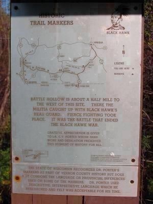
On Great River Road (State Highway 35) 2.5 miles north of Main Street (State Highway 82), on the right when traveling north.
Battle Bluff ↑ Elv 1139ft
Battle Hollow →
Severe fighting 1 mile east between Gen. Henry's 300 Ill. militia and 300 Sac Indians Aug. 2 1832.
← Battle Island
Hard fighting opposite. 1200 white soldiers . . . — — Map (db m24501) HM
Near High Street at Park Lane, on the right when traveling south.
The Battle of Hastings and Battle Abbey
The Battle of Hastings was fought here on 14 October 1066. It is the most famous battle on English soil and its outcome had a profound impact on the history of England.
William the Conqueror's . . . — — Map (db m128713) HM
Near Battlefield Trail 0.2 miles north of U.S. 90.
Here was fought on February 20, 1864
the Battle of Ocean Pond
under the immediate command of
General Alfred Holt Colquitt
"Hero of Olustee"
This decisive engagement prevented a
Sherman-like invasion of Georgia from
the south. . . . — — Map (db m54361) HM
On 14th Street at 5th Avenue, on the left when traveling west on 14th Street.
(obverse)
Before The Battle
All day that Easter Sunday the Confederate forces commanded by Col. Leon von Zinken awaited the Union Army they knew was on the way from Tuskegee. Lacking the men needed to hold it, they were forced to . . . — — Map (db m69058) HM
On State Highway 552 at Russum Westside Road, on the right when traveling north on State Highway 552.
Confederate General Martin Green had posted his brigade near magnolia church with at outpost at the A.K. Shaifer House. Shortly after midnight, Green rode forward to check on his pickets. The General found Mrs. Shaffer and the ladies frantically . . . — — Map (db m105844) HM
On East Boundary Street east of Wayne Street, on the right when traveling east.
"Finding no great effect from our fire, and confusion beginning to
spread from the great number of men who were falling in all quarters, it
became necessary to try what could be done with the bayonet."
--Major General Arthur St. . . . — — Map (db m137502) HM
On Wildersville Road 0.2 miles east of Tennessee Route 22, on the right when traveling east.
Prelude to Battle
Union troops in West Tennessee and north Mississippi depended on the railroad. The Confederate high command ordered General Nathan Bedford Forrest to cut that supply line. Forrest left Columbia on December 11, 1862, . . . — — Map (db m174205) HM
On West Main Street (Pennsylvania Route 31) at South Diamond Street ( Route 819), on the right when traveling east on West Main Street.
Navy Carrier launched airstrike Battle Of Midway 1942
Marine Corps raising the flag Battle of Iwo Jima 1945
Uncommon Valor was a Common Virtue
Distinguished Service Cross
Medal of Honor
Navy Cross
Air Force Cross
Distinguished . . . — — Map (db m204250) WM
On Pennsylvania Avenue at Westport Road, on the right when traveling north on Pennsylvania Avenue.
Price's Raid
Confederate General Sterling Price brought three mounted divisions from Arkansas into Missouri, September 19, 1864. Fighting several small battles he marched slowly north toward St. Louis, then struck westward to Jefferson City. . . . — — Map (db m20868) HM
Near Millard Farmer Road 0.4 miles east of Old Corinth Road, on the right when traveling east.
Anxious to avoid a fight, McCook left the 8th Indiana to contend with the
Confederates at the depot while the rest of his command detoured south on the East Newnan Road. Upon reaching Land Lot 38, near Turkey Creek, the column veered to the . . . — — Map (db m94662) HM
On Paris Pike (U.S. 27), on the left when traveling south.
(Front):1st Battle of CynthianaDuring CSA Col. John H. Morgan’s 1st KY Raid, on July 17, 1862, 875 CSA hit town via the Georgetown Pike. 350 US troops & Home Guard defended town from houses. Morgan attacked across Licking River and . . . — — Map (db m35858) HM
On West 3700 North, on the right when traveling north.
Utah’s largest-ever Indian Battle took place just north of Bulldog Boulevard (1200 North) and east of 500 West near what is now Riverside Plaza. It was fought in the cold and snow in February of 1850, less than a year after the Mormon colonizers had . . . — — Map (db m301644) HM
On Denver Avenue at East 60th Street, on the right when traveling north on Denver Avenue.
"To stand on a Civil War battlefield is to stand on holy ground, consecrated by American bravery and blood."
Support Battlefield Restoration and Interpretation
The Monnett Battle of Westport Fund in 2008 launched the Saving Kansas . . . — — Map (db m259107) HM
On Louisiana Route 175 0.3 miles north of Parish Road 48, on the right when traveling north.
From this point the line extended about 400 yards Northeast, thence East about a mile. It extended about a half mile South from here. — — Map (db m105293) HM
On Raritan Road, on the right when traveling north. Reported missing.
On the 26th of June in 1777 Washington’s continental forces of under 6,000 men fought a running battle on the plains below the Watchung Mountains with the combined British and Hessian troops numbering about 12,000. Early on that hot Thursday . . . — — Map (db m271267) HM
Battle of Clapp's Mill
On March 2, 1781, the American light troops under Colonel Otho Holland Williams of Maryland and Lieutenant Colonel Henry "Lighthouse Harry" Lee of Virginia engaged the British light troops near Clapp's Mill on Beaver . . . — — Map (db m28062) HM
Read Me First The following maps and text illustrate the battle at Belmont, Missouri. The battle is broken into sections that explain the components of the overall battle. To understand the progression of the battle, match the number above each . . . — — Map (db m37089) HM
Near Kentucky Route 235 0.1 miles Route 761, on the left when traveling south.
Alfred Edward Mathews, a renowned illustrator, created this drawing. We don't know if he participated in the battle, but it is obvious he was here. You are standing approximately where Mathews stood to sketch this scene. Compare the image to the . . . — — Map (db m137102) HM
Near Jones Road (Virginia Route 621) 0.4 miles south of Cedar Creek Grade ( Route 622), on the left when traveling south.
While Sandy Ridge played a prominent role in the First Battle of Kernstown, portions of two other Civil War battles occurred on this ridge as well.
The Second Battle of Winchester. In June 1863, Gen. Lee's Army of Northern Virginia . . . — — Map (db m310239) HM
On Oak Street at East Hibiscus Boulevard, on the right when traveling north on Oak Street.
Dedicated to the gallant and victorious men and women who participated in the Battle of the Bulge, World War II, 16 December 1944 thru 25 January 1945 in Belgium and Luxembourg. The greatest battle ever fought by the United States Army. The veterans . . . — — Map (db m195406) WM
Near Ferran Park Drive at East McDonald Avenue, on the right when traveling south.
In memory of the soldiers and Army nurses from the Golden Triangle Area who participated in the Battle of the Bulge, 16 December 1944 through 25 January 1945 in Belgium and Luxembourg. This major conflict with the German armies is regarded as the . . . — — Map (db m166537) HM WM
On West Main Road (Rhode Island Route 114) at Anselmo Drive, on the right when traveling south on West Main Road.
During the American Revolution the British strategy focused on controlling American ports and blockading the coast. Because of Newport’s significance as a deep-water port and as a center of trade, British forces landed in Newport in December of . . . — — Map (db m48348) HM
On Battle Mountain Avenue (U.S. 385) at Sherman Street, on the right when traveling north on Battle Mountain Avenue.
According to tradition, American Indians were stricken with an epidemic known as “fell disease” about the middle of the 16th century that threatened to obliterate the tribes. A messenger arrived from the Great West with news of a . . . — — Map (db m124081) HM
In Commemoration of the
1776
Battle of Round Mountain
(located Northwest of here)
in which Captain Thomas Howard
with his brave followers and
and faithful Indian guide, Skyuka,
won the battle against the Cherokee
Relocated by . . . — — Map (db m81159) HM WM
On Old Nottoway Road (U.S. 460) near The Grove Road, on the right when traveling west. Reported permanently removed.
“…the mingled roar of the musketry, and heavy lumbering of the artillery, seemed to rend the whole heavens…” At this railroad cut on June 23, 1864, 3,500 Union cavalrymen commanded by Gen. James H. Wilson fought a Confederate cavalry force . . . — — Map (db m6509) HM
On Grisham Street 0.4 miles south of Bethany Road (Mississippi Highway 370), on the right when traveling south.
Welcome to the Mississippi's Final Stands Interpretive Center. After visiting our museum gallery, we hope that you will tour the Brice's Crossroads and Tupelo battlefields for yourself, with the help of our audio tour and roadside signage.
. . . — — Map (db m91147) HM
Near East 63rd Street west of Manchester Trafficway, on the right when traveling west.
The Battle
When Confederate Maj. Gen. Sterling Price entered Jackson County, he commanded an army of around 12,000 troopers. He had amassed a train of around 500 wagons loaded with plunder and war supplies. As Price had marched across . . . — — Map (db m258395) HM
On U.S. 69, on the right when traveling south. Reported missing.
In October, 1864, a Confederate army under Gen. Stirling Price was defeated near Kansas City. He retreated south, crossed into Kansas, and camped at Trading Post. Early on the morning of October 25 Union troops under Generals Pleasonton, Blunt and . . . — — Map (db m6937) HM
Near State Park Road 0.1 miles south of Fallen Timbers Lane.
(Front)
The Greenville Treaty
To General Anthony Wayne who organized the “Legion of the United States” by order of President Washington and defeated Chief Little Turtle’s warriors here at Fallen Timbers August 20, 1794. . . . — — Map (db m8175) HM
Near Greensprings Road (Virginia Route 614) 0.2 miles north of 4-H Club Road ( Route 680), on the right when traveling north.
Hear the crack of flintlock muskets and smell the smoke from cannon fire! On this site, on July 6, 1781, 5,000 British troops under General Charles Cornwallis and Colonel Banastre Tarleton clashed with 900 American soldiers led by the Marquis de . . . — — Map (db m30651) HM
Dedicated to the men and women of the United States Army who participated in the Battle of the Bulge during World War II in Belgium and Luxembourg the greatest land battle fought by the United States Army under extreme winter conditions suffering . . . — — Map (db m54913) HM
On West Main Street near 12½ Street Northwest, on the right when traveling west.
The Battle Building at UVA Children's Hospital is named for Barry W. and William C. "Bill" Battle, longtime supporters of children's healthcare research and clinical care in central Virginia. Barry Webb Battle was inaugural chair of the UVA . . . — — Map (db m101182) HM
On Dublin Street at Obrien Avenue, on the right when traveling north on Dublin Street.
This anchor symbolizes the historic ties that Machias people have with the sea, and their commitment to liberty as exemplified in the first naval battle of the American Revolution fought in Machias Bay between the British ship Margaretta and the . . . — — Map (db m55066) HM WM
Near South Dixie Highway (U.S. 31W) 0.1 miles north of L and N Turnpike Road (Kentucky Highway 335), on the left when traveling north.
Organized in Houston in 1861 by Kentucky-born Texas sugar planter Benjamin Franklin Terry, the 8th Texas Cavalry would be better know throughout the Civil War as “Terry’s Texas Rangers”—though Terry was himself among the first casualties in the . . . — — Map (db m250221) HM
On Manning Road (U.S. 521), on the right when traveling south.
This tablet marks the site of the Battle of Dingle's Mill fought April 9, 1865 between Potter's Brigade and the Reserve South Carolina Militia C.S.A.
Erected by Dick Anderson Chapter U.D.C.
(Lower stone marker text)
The . . . — — Map (db m35746) HM
Near M.L.K. Jr Drive SW east of Wellington Street SW, on the left when traveling east.
After General John Bell Hood took command of the the army defending Atlanta he directed three Confederate failed attacks against Union Major General William T. Sherman's armies. On July 28, 1864, Union Major General Oliver O. Howard's "Army of the . . . — — Map (db m142514) HM
Near E. Robinson Street (State Road 526) at Cathcart Ave.
Dedicated to the gallant men and women who participated in the Battle of the Bulge, World War II, 16 December 1944 thru 25 January 1945 in Belgium and Luxembourg, the greatest battle ever fought by the United States Army. The Veterans of the Battle . . . — — Map (db m7450) HM
On Fork Shoals Road south of Old Hundred Road (County Road 565), on the right when traveling north.
Here along the south side of the creek to Reedy River was fought, Dec. 22, 1775, the Battle of Great Cane Break, between a force of South Carolinians under Colonel William Thompson and a band of Tories under Patrick Cuningham. The Tories were . . . — — Map (db m97258) HM
On State Highway 28 at Old Charleston Road (Local Road 38), on the left when traveling south on State Highway 28.
About four miles southeast is the site of the American Revolutionary Battle of Long Cane. On December 12, 1780, Lieutenant Colonel Isaac Allen and a British force of 400-500 men defeated Colonel Elijah Clarke and 100 Americans, an advanced . . . — — Map (db m241074) HM
On 546th Avenue (State Highway 121) 1.1 miles south of Front Street (U.S. 275), on the right when traveling south.
Near this site, July 12, 1859, Nebraska Territorial Militia and U. S. Army Dragoons, totaling 300 men, under the joint command of General John Milton Thayer and Lieutenant Beverly Holcombe Robertson, prepared to attack a large Pawnee village. . . . — — Map (db m189244) HM
On Court Street, on the right when traveling west.
This monument commemorates the pivotal June 28, 1778 Battle of Monmouth which began near this site. A campaign to erect the memorial, led by Freehold native Governor Joel Parker and Major James S. Yard, began in 1877. Its cornerstone was laid on . . . — — Map (db m53132) HM
On 18th Avenue at 84th Street, on the right when traveling north on 18th Avenue.
On July 4, 1776, the Declaration of Independence proclaimed to the world that thirteen British colonies had joined together to create a new nation: the United States of America. Here in Brooklyn, only two months later, the survival of that new . . . — — Map (db m30175) HM
Near Sheridan Loop at Sterling Drive, on the right when traveling east.
On July 4, 1776, the Declaration of Independence proclaimed to the world that thirteen British colonies had joined together to create a new nation: the United States of America. Here in Brooklyn, only two months later, the survival of that new . . . — — Map (db m21613) HM
On Gravesend Neck Road, on the left when traveling west.
On July 4, 1776, the Declaration of Independence proclaimed to the world that thirteen British colonies had joined together to create a new nation: the United States of America. Here in Brooklyn, only two months later, the survival of that new . . . — — Map (db m30174) HM
On Elizabeth Avenue at South McDowell Street, on the right when traveling east on Elizabeth Avenue.
In commemoration
of
the Battle of Charlotte
Sept. 26, 1780
Erected by The Battle of
Charlotte Chapter, Daughters
of the American Revolution
1918
“For God and my country I stand” — — Map (db m237675) WM
On Cross Keys Highway (State Highway 49) at Blackstock Road, on the left when traveling east on Cross Keys Highway.
This battle of the Revolution took
place on William Blackstock’s
plantation, 3 miles N. on the south
side of the Tyger River, November 20,
1780. Gen. Thomas Sumter
commanded the American patriots who
repulsed Lt. Col. Banastre
Tarleton’s . . . — — Map (db m11111) HM
On Siege Road 2.4 miles south of Oaklawn Boulevard ( Route 36), on the right when traveling south.
By March 1865 Confederate General Robert E. Lee had suffered through nearly nine months of fighting, had repulsed seven Union offensives, and had his men spread along a 37-mile-long front. Knowing that it was only a matter of time before his lines . . . — — Map (db m85861) HM
Near Lundy's Lane, on the left when traveling west.
British and American forces suffered heavy losses at the Battle of Lundy’s Lane on July 25, 1814 and these were severe in proportion to the number of combatants. The casualty rates were nearly equal, as each side recorded around 800 casualties, . . . — — Map (db m283711) HM
Near New York State Route 3 north of Nash Road, on the left when traveling north.
Americans Set An Ambush
An American flotilla carrying critical shipbuilding supplies to Sackets Harbor was forced to land along South Sandy Creek. Near this spot Major Appling's 120 riflemen, 150 Oneida Indian warriors and naval Captain . . . — — Map (db m75733) HM
On Constitution Highway (State Highway 20), on the right when traveling west.
This short trail leads to "Grant's Knoll." For three days Gen. Ulysses S. Grant made his headquarters here, issuing orders that would determine the fate of armies and men. President Abraham Lincoln had recently appointed Grant general-in-chief over . . . — — Map (db m7403) HM
Near Main Street 0.1 miles south of Ocean Street, on the left when traveling south.
Dedicated to the gallant and victorious men and women who participated in the Battle of the Bulge. The greatest battle ever fought by the United Stated Army in Belgium and Luxembourg during World War II, 16 December 1944 thru 25 January . . . — — Map (db m142706) WM
On Denver Avenue at East 60th Street (Route E. 63rd), on the right when traveling north on Denver Avenue.
The Situation
Late in the day on October 22, Union Maj. Gen. Alfred Pleasonton's cavalry drove the Confederate rear guard from Independence. The Union cavalry continued pursuing the enemy's withdrawal down the Byram's Ford Road until 10:30 . . . — — Map (db m259105) HM
On Avenue of Memories at Wilson Ave, on the right when traveling east on Avenue of Memories.
Dedicated to the gallant men and women of
the United States Armed Forces who
participated in the “Battle of the Bulge,”
fought in Belgium and Luxembourg during
World War II. The greatest battle ever engaged
in by the United States Army lasted . . . — — Map (db m6964) WM
On Arlington Cemetery south of Farragut Drive, on the right when traveling south.
Dedicated to the gallant and victorious men and women who participated in the Battle of the Bulge, World War II, 16 December 1944 thru 25 January 1945 in Belgium and Luxembourg. The greatest battle ever fought by the United States Army. Presented by . . . — — Map (db m137217) WM
On Valley Pike (U.S. 11), on the right when traveling north.
The Battle of Cedar Creek 19 October 1864 (a.m.) Maj. Gen. Philip Sheridan’s Union forces established themselves on both sides of the Valley Pike, north of Cedar Creek, centered on Belle Grove. Confederate Lt. Gen. Jubal A. Early . . . — — Map (db m15171) HM
On July 4, 1776, the Declaration of Independence proclaimed to the world that thirteen British colonies had joined together to create a new nation: the United States of America. Here in Brooklyn, only two months later, the survival of that new . . . — — Map (db m31009) HM
On Battle Avenue, on the left when traveling north.
On July 4, 1776, the Declaration of Independence proclaimed to the world that thirteen British colonies had joined together to create a new nation: the United States of America. Here in Brooklyn, only two months later, the survival of that new . . . — — Map (db m13255) HM
Near New Jersey Route BUS 33, on the left when traveling east.
During the afternoon of Sunday, June 28, 1778, the hills and meadows in front of you disappeared under clouds of gun smoke. When the firing subsided, over 600 men were dead, dying or wounded, and the Continental Army held the field. The Battle of . . . — — Map (db m37741) HM
Near Swan Hollow Road east of Taylor Road, on the left when traveling east.
The Battle of Cranberry Creek was typical of many cross-border engagements fought along the New York border with British Canada during the War of 1812. A force of about 50 Americans fended off an attack by 250 British Soldiers. Several American . . . — — Map (db m179231) HM
On Chesterfield Street NE near Richland Avenue (U.S. 78), in the median.
Near this spot on February 11, 1865
was fought one of the final Confederate
victories of the War Between The States.
Federal Cavalry commanded by Major
General Hugh Judson Kirkpatrick were
attacked by Confederate Cavalry
commanded by . . . — — Map (db m10061) HM
On Boykin Road (State Highway 261) at Boykin Mill Road, on the left when traveling south on Boykin Road.
Gen. Edward E. Potter commanding 2700 white and Negro Union troops left Georgetown April 5, 1865, to destroy the railroad between Sumter and Camden. Here on April 18, in one of the last engagements of the war, a small force of Confederate . . . — — Map (db m27623) HM
On Main Street (Virginia Route 131), on the right.
You are standing near the site of Appomattox Station Depot on the South Side Railroad. Here, on the afternoon of April 8, 1865, Union cavalrymen under Gen. George A. Custer dealt the Army of Northern Virginia a final blow. First, they captured . . . — — Map (db m156545) HM
On Winfield Road (U.S. 35) 0.5 miles south of Interstate 64, on the right when traveling south.
First Confederate victory in Kanawha Valley fought here July 17, 1861. Charge of the Rangers under Captain (later General) Jenkins won the day. Whitelaw Reid described the event as a war correspondent with Gen. Cox's Union forces. — — Map (db m20787) HM
Near Charlie Dowling Road 0.3 miles north of South Dixie Highway (U.S. 31W), on the left when traveling south.
The mound on the hilltop before you is Fort Craig, a five-pointed earthen “star fort” that saw the fiercest fighting of the Civil War Battle and Siege of Munfordville, September 14-17, 1862. Forces of the 7th, 9th, and 29th Mississippi Infantry, . . . — — Map (db m250218) HM
Near Hardesty Avenue 0.2 miles north of 63rd Street, on the left when traveling north.
History of Byram's Ford
Freighter Augustine Byram from Kentucky settled here in 1839. Overlooking the Byram's Ford crossing of the Big Blue River, his log cabin stood 900 yards west of here on the rise dubbed by the soldiers in 1864 as . . . — — Map (db m187187) HM
On New Dover Road (England Route B2011) at Old Dover Road, on the right when traveling east on New Dover Road.
The Christopher Foxley-Norris
Memorial Wall
Is Dedicated To The Aircrew
Who Flew During
The Battle of Britain
10th July 1940 — 31st October 1940
“Never in the field of human conflict
was so much owed by so many to so . . . — — Map (db m123862) WM
Near Manchester Trafficway 0.5 miles north of East 63rd Street Trafficway when traveling north.
Clash at Byram's Ford
At 10:00 AM on October 22, 1864, six hundred feet in front of you, Lt. Col. George H. Hoyt of the 15th Kansas Cavalry formed a skirmish line to resist the advance of the Confederate army across the Blue River at Byram's . . . — — Map (db m226627) HM
On Battleground Avenue west of Railroad Street, on the right when traveling north.
Here, on this site, military forces commanded by General William Henry Harrison, engaged in battle with the Indians of the Wabash country led by The Prophet, brother of the great Indian leader, Tecumseh. This battle destroyed forever the hope of . . . — — Map (db m36205) HM
On W Main Road (Rhode Island Route 114), on the left when traveling north.
The 1st Rhode Island Regiment of the Continental Line 1775 – 1783 The war for American Independence was a long and arduous struggle that demanded much of the American people. Rhode Island responded to those demands with patriotic fervor, . . . — — Map (db m48374) HM
On Mill Street east of Market Street, on the right when traveling east.
Second Battle of Newtonia
A few miles southwest of this location, the Second Battle of Newtonia was fought on Oct. 28, 1864. The conflict came near the end of Maj. Gen. Sterling Price’s celebrated invasion of Missouri. With the Federals . . . — — Map (db m65018) HM
On Donohoe Road 0.2 miles east of Georges Station Road (Pennsylvania Route 1053), on the right when traveling east.
1944 • 2000
This memorial is dedicated to all Western Pennsylvania Veterans who participated and were victorious in
"The Battle of the Bulge" WWII in Belgium and Luxembourg December 16, 1944 through January 25, 1945
That battle will . . . — — Map (db m281983) WM
On East 2000th Road at North 175th Road, on the right when traveling south on East 2000th Road.
"Let not the knives of pro-slavery men be sheathed while there is one abolitionist in the Territory." —Squatter Sovereign proslavery newspaper in Atchison, Kansas Territory, June 10, 1856
On this site at dawn on June 2, 1856, the . . . — — Map (db m20051) HM
Near Carretera Tepatitlán de Morelos - Zapotlanejo (Route 80).
Reseña de la Batalla del Puente de CalderónBatalla de Puente de Calderón es parte de la guerra de independencia de México. La batalla fue trabada entre fuerzas insurgentes y fuerzas realistas, el 17 de enero de 1811. El Puente se . . . — — Map (db m100364) WM
Near S. McCune Street south of Maple Street (Missouri Highway 221), on the right when traveling north.
Battle of Pilot Knob Pilot Knob Mountain September 27, 1864 1:00 P.M. - 2:30 P.M.Prior to the Confederate attack on Ft. Davidson a detachment of 3rd M.S.M. Cavalry was forced off Pilot Knob Mountain by Slemons' and McCray's Rebel Brigades. The 3rd . . . — — Map (db m38445) HM
On State Highway 80, on the right when traveling east.
North and west of this location, the Battle of Belmont was fought on November 7, 1861. It was the first battle in which Ulysses S. Grant commanded an army. He had recently been promoted to Brigadier General and placed in command of the federal . . . — — Map (db m17763) HM
Near Redbud Road (County Route 661), on the right when traveling east. Reported permanently removed.
After the successful attack of the Union Eighth Corps, it was only a matter of time before the Confederates lost the battle. As Confederate Gen. Early consolidated his lines closer and closer to Winchester, his men faced coordinated infantry . . . — — Map (db m167715) HM
Near Charlie Dowling Road 0.3 miles north of South Dixie Highway (U.S. 31W), on the left when traveling north.
An “unauthorized and injudicious” attack …
General James R. Chalmers was sent by General Bragg as a vanguard to Cave City. There, Chalmers learned from Col. John Scott of a weak Union garrison at Munfordville. Eager for glory—and without . . . — — Map (db m250220) HM
Near Charlie Dowling Road 0.3 miles north of South Dixie Highway (U.S. 31W), on the left when traveling north.
When Braxton Bragg arrived at Green River, Cyrus Dunham had taken command of the Union garrison. The 15th had been spent clearing casualties from the field, but by the next day, gunfire erupted from Bragg’s advance guard, starting a day-long . . . — — Map (db m250219) HM
On Louisiana Route 175 north of Patrick Road, on the right when traveling north.
Front
On this 4 square miles in around the village of Pleasant Hill, approx. 15,000 Confederates under Maj. Gen. Richard Taylor attacked approx. 25,000 Union troops under Maj. Gen. N. P. Banks on April 9, 1864. That was the 3rd day of . . . — — Map (db m105670) HM
On Park Central East east of South Avenue, on the left when traveling east.
The Battle of Springfield
This location is the approximate site of Fort No. 4. During the Civil War, this four-sided earthen fort served as the main defensive work during the Battle of Springfield. This battle occurred during the raid, or . . . — — Map (db m173594) HM
On Church Mall 0.1 miles north of Morris Avenue (New Jersey Route 124), on the left when traveling north.
Their deeds enriched
and glorified our nation.
This gate is dedicated
in commemoration of
the heroic service performed at
The Battle of Springfield
during the war for
American Independence
by the soldiers whose remains are . . . — — Map (db m7001) HM
Near Battle Avenue, on the left when traveling north.
You now stand on Green-Wood Cemetery’s Battle Hill, the highest natural elevation in Brooklyn. On the morning of August 27, 1776, had you stood here, you would have seen the Battle of Brooklyn developing in front of you. British General James . . . — — Map (db m69525) HM
On 5th Avenue at 3rd Street, on the right when traveling south on 5th Avenue. Reported permanently removed.
On July 4, 1776, the Declaration of Independence proclaimed to the world that thirteen British colonies had joined together to create a new nation: the United States of America. Here in Brooklyn, only two months later, the survival of that new . . . — — Map (db m30997) HM
Near Armstrong Street east of Chain Bridge Road (Virginia Route 123), on the right when traveling east.
Dedicated to the gallant and victorious men and women who participated in the Battle of the Bulge, World War II, 16 Dec 1944 thru 25 Jan 1945, in Belgium and Luxembourg. The greatest battle was fought by the United States Army, Presented by the . . . — — Map (db m178641) WM
On West Ocean View Avenue (Virginia Route 168) just east of Richview Street, in the median.
On March 9, 1862, the first battle between ironclad ships occurred in Hampton Roads when the U.S.S. Monitor and the C.S.S. Virginia (Merrimack) met in a naval engagement which opened the era of the armored warship. — — Map (db m21215) HM
On Sacandaga Road (New York State Route 147), on the right when traveling north.
1748 1929
In Memory
Of The Men Who Were Killed
In This Ravine In
The Beukendaal Battle
On July 18, 1748
By The Canadian Indians
John A. Bradt
Johannes Marinus
Peter Vrooman
Daniel Van Antwerpen
Cornelis Viele, . . . — — Map (db m102619) HM
On Main Street (Virginia Route 236) at Oak Street, on the right when traveling west on Main Street. Reported permanently removed.
During the First Battle of Manassas, amid the smoke of combat, troops found it difficult to distinguish between Union and Confederate flags. Generals P.G.T. Beauregard, Joseph E. Johnston and Quartermaster General William L. Cabell met near here in . . . — — Map (db m101514) HM
Near High Street at Castle Gate, on the left when traveling east.
The Battle of Lewes, 1264
A violent clash between the barons and the King
Standing here on 14th May 1264 you would have witnessed one of the most important battles between rebel barons and King Henry III.
The King had a reputation for . . . — — Map (db m129689) HM
On North Washington Avenue at Champion Street, on the left when traveling south on North Washington Avenue.
Battle Creek Sanitarium The Battle Creek Sanitarium opened in 1866 as the Western Health Reform Institute. The institute was founded on health principles advocated by the Seventh-Day Adventist Church. In 1876 Dr. John Harvey Kellogg became the . . . — — Map (db m177255) HM
Near Bloomery Road (County Road 27), on the right when traveling south.
(Upper Panel): Battle of Harpers Ferry Invasion rocked the United States during the second year of the American Civil War. In September 1862 Confederate General Robert E. Lee launched his army into Maryland - the North. Lee's first target . . . — — Map (db m168651) HM
On North 5th Street south of Washington Street, on the left when traveling south.
In Memory of
Veterans
Battle of the
Bulge
Triumph of Courage
World War II
Dec.16, 1944 – Jan. 25, 1945
This is undoubtedly the greatest American
battle of the war and will, I believe, be
regarded as an ever . . . — — Map (db m42768) HM
On Morgan Street, on the right when traveling east.
On June 17, 1861, the Battle of Boonville took place at this and other locations along this road. By most standards of warfare, the Battle of Boonville was more truly a skirmish or demonstration than a full blown battle. But small conflicts can . . . — — Map (db m46060) HM