By Bill Coughlin, July 31, 2010
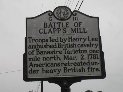
Battle of Clapp's Mill Marker
RANKED BY RELEVANCE, THEN GEOGRAPHICALLY
| On North Carolina 62 (North Carolina Route 62) at Porter Sharpe Road, on the right when traveling south on North Carolina 62. |
| On Snow Camp Road, 0.2 miles south of Greensboro-Chapel Hill Road. |
| On East Penn Street, 0.1 miles north of Blakeslee Boulevard, on the left when traveling north. |
| On Flandreau Park Road, 0.3 miles north of 230th Street, on the right when traveling north. |
| Near Park Drive (State Highway 92 Spur) 0.3 miles west of U.S. 77, on the right when traveling west. |
| Near Rock Creek Road, 0.2 miles north of Steinbeck Bend Drive. |
| On Lee Highway (U.S. 211/340) 0.1 miles east of Kauffman's Mill Road, on the right when traveling west. |
| On Whitman Mission Road near Sweagle Road. |
| On Houfnaggle Road (County Route 35) 1.8 miles south of Midland Trails Road (U.S. 60), on the left when traveling north. |
| On Warburton Avenue at Broadway (U.S. 9), on the right when traveling south on Warburton Avenue. |
| On County Highway 44 at County Highway 61.5, on the right when traveling west on County Highway 44. |
| Near Greenmanville Avenue (Connecticut Route 27) north of Hinckley Street, on the left when traveling north. |
| On Pennsylvania Avenue at Katherine Dunham Place, on the right when traveling east on Pennsylvania Avenue. |
| On North 9th Street just south of Pennsylvania Avenue, on the right when traveling west. |
| On Oak Orchard Road, 0.2 miles west of Henry Clay Boulevard, on the left when traveling west. |
| Near Avenida 3, Paseo de las Damas close to Calle 19. |
| On De la Balme Road at East Old Trail Road, on the right when traveling north on De la Balme Road. |
| On Monument Square at Monument Ave. on Monument Square. |
| On Devonshire Street at State Street, on the left when traveling north on Devonshire Street. |
| On Red Oak Drive at Rivervale Road, on the right when traveling east on Red Oak Drive. |
| Near Old Cedar Bridge Road, on the left when traveling west. |
| Near Mt. McGregor Road, on the right when traveling north. |
| On Calhoun Drive, on the right when traveling south. |
| On Jefferson Davis Highway (U.S. 1) at Marina Drive, on the right when traveling north on Jefferson Davis Highway. |
| On Lee Highway (U.S. 11) 2.2 miles north of Interstate 81, on the right when traveling north. |
| On Kane Street (Business U.S. 58) east of Jones Street, on the left when traveling west. |
| Near County Highway W east of Chief White Antelope Way. |
| Near 3rd Avenue Southwest east of Oak Street South, on the right when traveling east. |
| Near 4th Street (U.S. 287) west of 7th Avenue, on the right when traveling west. |
| On Clarence Street, on the right when traveling north. |
| On Paseo General Escalón, on the left when traveling west. |
| On Calle Principal, on the left when traveling west. |
| On Highway Chm. 2, on the left when traveling south. |
| On 7a Avenida just north of 8a Calle, on the right when traveling north. |
| On Alarcón de Ocaña at Nicolás Romero, on the right when traveling south on Alarcón de Ocaña. |
| On Droga krajowa 28 just west of Walerego Waygarta, on the right when traveling west. |
| On Second Avenue East (US Highway 231) at 4th Street North, on the right when traveling west on Second Avenue East (US Highway 231). |
| On U.S. 431, 2 miles north of State Route 144, on the right when traveling south. |
| On Barber Street, 0.1 miles north of East 26th Street, on the right when traveling north. |
| On Hanford Street (State Highway 49), on the right when traveling south. |
| On Old Alturas Highway (County Route 114) 1.1 miles north of County Route 101, on the left when traveling north. |
| On McArthur Road (State Highway 299), on the left when traveling east. |
| On Sherman Street. Reported permanently removed. |
| On Colorado Street (State Highway 86). |
| Near County Highway W just east of Chief White Antelope Way. |
| On West 1st Street (U.S. 34) at Custer Avenue, on the left when traveling west on West 1st Street. |
| Near Park Avenue at Monument Street, on the left when traveling west. |
| On Monument Street at Park Avenue, on the left when traveling south on Monument Street. |
| On Thames Street at Latham Street, on the right when traveling north on Thames Street. |
| On Marion Street (SR 47) (U.S. 441) at NW Orange Street, on the right when traveling north on Marion Street (SR 47). |
| On U.S. 98, 0.1 miles north of County Road 721, on the right when traveling north. |
| On East Fort King Street at Southeast 39th Terrace, on the right when traveling west on East Fort King Street. |
| On Ocean Drive south of 8th Street, on the right when traveling south. |
| On U.S. 98/301 at Bluegrass Road, on the right when traveling north on U.S. 98/301. Reported missing. |
| Near Phillipe Park Drive east of Philippe Parkway, on the left when traveling south. |
| On Camp Mack Road at Rosalie Boulevard, on the right when traveling east on Camp Mack Road. Reported permanently removed. |
| On Burns Avenue (State Road 17) at Tower Boulevard, on the right when traveling east on Burns Avenue. Reported permanently removed. |
| On U.S. 129 at milepost 17 at Wayfare Road (County Route 1), on the right when traveling south on U.S. 129. |
| On West Main Street south of Church Street, on the right when traveling south. |
| Near North Perry Street (Georgia Route 20) at West Pike Street (U.S. 29), on the left when traveling south. |
| Near South 1st Street West near West Center Street. |
| On North 1550th Street north of 1600th Avenue, on the right when traveling north. |
| On North 3rd Street at Missouri Avenue, on the left when traveling west on North 3rd Street. |
| On Riverview Drive south of East Laughery Creek Road, on the right when traveling south. |
| Near County Road 500 S near East Street. |
| Near Edrington Boulevard, 0.2 miles north of U.S. 31, on the right when traveling north. |
| On N. Main Street (State Road 135) 0.3 miles north of Emma Street, on the right when traveling south. |
| Near Circle Drive north of Miriam Lane, on the right when traveling north. |
| On Massachusetts Street at 7th Street, on the left when traveling north on Massachusetts Street. |
| On Washington Street (U.S. 51) at Clay Street (State Highway 58), on the right when traveling south on Washington Street. |
| On Mountain Life Museum Road at Levi Jackson Road (Kentucky Route 1006), on the left when traveling east on Mountain Life Museum Road. |
| On Bloomfield Road (U.S. 62) at Brown's Lane (County Route 2230), on the left when traveling north on Bloomfield Road. |
| On Broadway Street (U.S. 25) at E. Main Street (U.S. 460), on the right when traveling north on Broadway Street. |
| On Conway Street, on the right when traveling south. |
| On Millers Falls Road (Massachusetts Route 63) close to Homer Road, on the right when traveling north. |
| On Lake Shore Drive (State Highway 185) at British Landing Road, on the left when traveling north on Lake Shore Drive. |
| On Riverside Drive, 0.1 miles west of State Street, on the left when traveling west. |
| On 1st Street at 13th Avenue, on the right when traveling west on 1st Street. |
| On Bonhomme Avenue just west of South Hanley Road, on the left when traveling west. |
| On 6th Avenue Bypass, 0.1 miles south of E. Airport Road, on the left when traveling south. |
| On Locust Island Road at New Street, on the right when traveling east on Locust Island Road. |
| On State Road 338 at milepost 24.4 at State Road 9, on the left when traveling north on State Road 338. |
| On North Main Street (New York State Route 247) at Railroad Street, on the right when traveling south on North Main Street. |
| On Kings Highway at Washington Street, on the right when traveling north on Kings Highway. |
| Near State Street, in the median. |
| On Naples Hill Road (New York State Route 53) just north of Chapel Street, on the right when traveling north. |
| Near Canada Street (U.S. 9), on the right when traveling north. |
| On Broadway (U.S. 4) at Case Street, on the right when traveling south on Broadway. |
| On Main Street at Mallarnee Road, on the right when traveling west on Main Street. |
| On Mulberry Street near Sherman Street. |
| Near South Bierley Avenue, on the right when traveling south. |
| On U.S. 81, 0.2 miles south of County Road E0550, on the right when traveling south. |
| Near Honey Springs Battlefield Road, 1.4 miles north of East 1020 Road, on the right when traveling north. |
| On Water Street west of Harrison Street, on the right when traveling east. |
| On Monument Avenue, on the left when traveling west. |
| On Great Cove Road (U.S. 522) at Rock Hill Road (Local Route 379), on the left when traveling south on Great Cove Road. |
| On River Road (Pennsylvania Route 3030) 0.1 miles south of Safe Harbor Road, on the right when traveling south. |
| On Valley Street at Wyoming Avenue (U.S. 11), on the right when traveling east on Valley Street. |
987 entries matched your criteria. Entries 301 through 400 are listed above.
⊲ Previous 100 —
Next 100 ⊳
* Inflectional forms of words are their plurals, singulars, and possessives as well as gramatical tenses and similar variations.