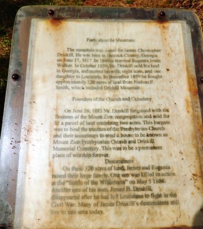
By Cosmos Mariner, May 23, 2014
Marker detail: top/text
| Near State Highway 507 2.7 miles west of State Highway 147, on the right when traveling west. |
| On State Highway 507 0.8 miles west of State Highway 797, on the right when traveling west. |
| On Kepler Road (State Highway 507) at Old Sparta Road, on the right when traveling west on Kepler Road. |
| On State Highway 154 3 miles south of State Highway 793, on the right when traveling south. |
| On State Highway 154 8 miles south of Gibsland / I-20, on the right when traveling south. |
| On Main Street (U.S. 80) north of South 2nd Street, on the right when traveling south. |
| On U.S. 71 0.2 miles north of State Highway 4, on the right when traveling north. |
| On State Highway 9 at Briarwood Road, on the right when traveling south on State Highway 9. |
| On Louisiana 507 0.1 miles east of Flatwood Road, on the left when traveling west. |
| Near Shreveport Road at Lindbergh Road. |
| Near Shreveport Road at Lindbergh Road. |
| Near Shreveport Road at Lindbergh Road. |
| Near Shreveport Road at Lindbergh Road. |
| Near Shreveport Road at Lindbergh Road. |
| Near Shreveport Road at Lindbergh Road. |
| Near Range Road 0.1 miles north of Shreveport Road. |
| Near Range Road 0.1 miles north of Shreveport Road. |
| Near Range Road 0.1 miles north of Shreveport Road. |
| Near Lindbergh Road at Shreveport Road. |
| Near Shreveport Road at Lindbergh Road. |
| On Bodcau Dam Road at Bellevue Cemetery Road, on the left when traveling east on Bodcau Dam Road. |
| On Louisiana Route 157 north of Bodcau Dam Road, on the left when traveling north. |
| On Burt Boulevard east of State Route 3, on the right when traveling west. |
| On Bossier Street at Bellevue Street, on the right when traveling south on Bossier Street. |
| On Traffic Street just north of Adair Street, on the right when traveling north. |
| On Range Road 0.4 miles north of Shreveport Road, on the right when traveling north. |
| On Range Road 0.3 miles north of Shreveport Road, on the right when traveling north. |
| On Range Road 0.2 miles north of Shreveport Road, on the left when traveling north. |
| On Range Road 0.2 miles north of Shreveport Road, on the left when traveling north. |
| On Range Road 0.3 miles north of Shreveport Road, on the right when traveling north. |
| On Range Road 0.4 miles north of Shreveport Road, on the right when traveling north. |
| On Range Road 0.5 miles north of Shreveport Road, on the right when traveling north. |
| Near Range Road at Shreveport Road, on the right when traveling north. |
| On Range Road 0.3 miles north of Shreveport Road, on the right when traveling north. |
| On Range Road 0.5 miles north of Shreveport Road, on the right when traveling north. |
| On Range Road 0.2 miles north of Shreveport Road, on the left when traveling north. |
| On Range Road 0.2 miles north of Shreveport Road, on the left when traveling north. |
| On Range Road 0.2 miles north of Shreveport Road, on the right when traveling north. |
| On Range Road 0.5 miles north of Shreveport Road, on the right when traveling north. |
| On Range Road 0.2 miles north of Shreveport Road, on the left when traveling north. |
| On Range Road 0.4 miles north of Shreveport Road, on the right when traveling north. |
| On Range Road 0.5 miles north of Shreveport Road. |
| On Barksdale Boulevard (State Highway 72) at Monroe Street, on the right when traveling east on Barksdale Boulevard. |
| On Fillmore Cemetery Road at State Highway 157, on the right when traveling west on Fillmore Cemetery Road. |
| On South Elm Street (Louisiana Route 157) 0.2 miles south of Fox Creek Street, on the right when traveling north. |
| On Johnson Koran Road 1 mile north of State Highway 527, on the left when traveling north. |
| On Louisiana Route 157 north of Davis Road, on the left when traveling north. |
| On Louisiana Route 612 west of Rogers Lane ( Route 157), on the left when traveling west. |
| On U.S. 71 0.3 miles south of Gamble Road, on the right when traveling north. |
| On Gray Street (Louisiana Route 3049) north of Olympia Road, on the right when traveling north. |
| On Church Street north of White Street, on the right when traveling north. |
| On Gray Street (State Highway 3049) north of Louisiana Street, on the right when traveling north. |
| On Gray Street (State Highway 3049) north of Louisiana Street, on the right when traveling north. |
| On Louisiana Route 3049 at Belcher River Road, on the right when traveling north on Louisiana Route 3049. |
| On Dixie Shreveport Road (Louisiana Route 3049) 1 mile north of Route 169, on the right when traveling north. |
| On State Highway 3049 at Cedar Bluff Road, on the right when traveling north on State Highway 3049. |
| On Caddo Street (State Highway 3049) at East Street, on the right when traveling east on Caddo Street. |
| On Caddo Street west of Line Street, on the right when traveling west. |
| On Louisiana Route 3049 1 mile north of Cedar Bluff Road, on the right when traveling north. |
| On Gray Street (State Highway 3049) north of Parish Road 136, on the right when traveling north. |
| On State Highway 3049 0.2 miles south of Cavett River Road, on the right when traveling north. |
| On Railroad Street (State Highway 3049) at Caddo Street, on the left when traveling north on Railroad Street. |
| On Caddo Street (State Highway 3049) east of East Street, on the left when traveling east. |
| On Dixie Shreveport Road (Louisiana Route 3049) south of Route 169, on the left when traveling north. |
| On Dixie Shreveport Road (State Highway 3049) south of Cornhusker Road, on the left when traveling north. |
| On Dixie Shreveport Road (Louisiana Route 3049) 0.5 miles south of Route 169, on the left when traveling north. |
| On Dixie Shreveport Road (Louisiana Route 3049) north of Route 169, on the right when traveling north. |
| On Dixie Shreveport Road (Louisiana Route 3049) at Cornhusker Road, on the right when traveling north on Dixie Shreveport Road. |
| On Main Street north of 2nd Street, on the right when traveling north. |
| On Main Street north of 2nd Street, on the right when traveling north. |
| On Adger Road at Piarce Lane, on the right when traveling east on Adger Road. |
| On Louisiana Route 3049 0.5 miles south of Sherman Drive, on the left when traveling south. |
| On Louisiana Route 3049 south of Sartor Road, on the left when traveling south. |
| On Adger Road east of Piarce Lane, on the right when traveling east. |
| On Main Street at 2nd Street, on the left when traveling south on Main Street. |
| On 1st Street 0.1 miles west of Main Street, on the right when traveling east. |
| On Greenwood Road (U.S. 80) at Nixon Street, on the left when traveling west on Greenwood Road. |
| On U.S. 71 0.2 miles south of State Route 2, on the right when traveling north. |
| On Parkway Drive north of Briar Rose Street, on the left when traveling north. |
| On U.S. 71 0.1 miles north of Camellia Street, on the right when traveling north. |
| On East Magnolia Lane near U.S. 71, on the right when traveling east. |
| On East Magnolia Lane east of U.S. 71, on the right when traveling east. |
| On Old Mansfield Road south of Keithville Lodge Road, on the right when traveling north. |
| On Louisiana Route 538 north of E Croom St, on the right when traveling south. |
| On South Kerley Avenue at Savage Street, on the right on South Kerley Avenue. |
| On Williamson Parkway 0.2 miles west of State Route 1, on the left when traveling west. |
| On State Highway 1 at Williamson Parkway, on the right when traveling north on State Highway 1. |
| On Williamson Parkway west of State Highway 1, on the left when traveling west. |
| Near S. Land Avenue 0.1 miles north of Savage Street, on the right when traveling north. |
| On South Land Avenue 0.1 miles south of Savage Street, on the left when traveling north. |
| On West Front Street (State Highway 1) north of Main Street (State Highway 168), on the left when traveling north. |
| On West Front Street (State Highway 1) 0.2 miles north of Main Street (State Highway 168), on the right when traveling north. |
| On Dixie Shreveport Road (Route 3049) at Cash Point Plantation Road, on the right when traveling north on Dixie Shreveport Road. |
| On Dixie Shreveport Road (Louisiana Route 3049) 0.5 miles north of Whitefield Circle, on the right when traveling north. |
| On Dixie Shreveport Road (Louisiana Route 3049) 1 mile north of Cash Point Plantation Road, on the right when traveling north. |
| On Dixie Shreveport Road (Louisiana Route 3049) at Sentell Road, on the right when traveling north on Dixie Shreveport Road. |
| On Dixie Shreveport Road (State Highway 3049) 0.2 miles north of Moon Lake Farm Road, on the right when traveling north. |
| On Dixie Shreveport Road (Louisiana Route 3049) 1 mile south of Sentell Road, on the left when traveling north. |
| On Dixie Shreveport Road (Louisiana Route 3049) 1 mile north of Cash Point Plantation Road, on the right when traveling north. |
545 entries matched your criteria. The first 100 are listed above.
Next 100 ⊳
