83 entries match your criteria.
Entries Containing All of the Phrases «washington county» AND «maryland»
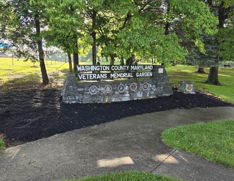
By Bradley Owen, May 29, 2024
Washington County Maryland Veterans Memorial Garden Marker
RANKED BY RELEVANCE
1 ► Maryland, Washington County, Halfway — Washington County Maryland Veterans Memorial Garden —  |
| Near Halfway Boulevard at Oak Valley Drive, on the left when traveling north. | |||
| 2 ► Maryland, Washington County, Williamsport — The Boys of Williamsport — |
| On West Potomac Street (U.S. 11) at North Conococheague Street (Maryland Route 63), on the right when traveling east on West Potomac Street. | |||
| 3 ► Maryland, Washington County, Boonsboro — Devil's Backbone Dam Rehabilitation — |
| On Lappans Road (Maryland Route 68) just north of Printz Road, on the right when traveling north. | |||
| 4 ► Maryland, Washington County, Williamsport — Confederate Hospitals in Williamsport — |
| On East Potomac Street (U.S. 11) west of North Artizan Street. | |||
| 5 ► Maryland, Washington County, Hagerstown — The Last Confederate Incursion North of the Potomac River — |
| On South Potomac Street (State Highway 65), on the right when traveling north. | |||
| 6 ► Maryland, Washington County, Hagerstown — Thomas Kennedy — (1776-1832) — |
| On Potomac Street (Maryland Route 65) 0.1 miles south of Memorial Boulevard, on the left when traveling south. | |||
| 7 ► Maryland, Washington County, Benevola — Roxbury Mills Bridge — |
| On Roxbury Road, on the right when traveling south. | |||
| 8 ► Maryland, Washington County, Funkstown — Building the Funkstown Bridge — The Historic National Road - The Road That Built The Nation — |
| On North Westside Avenue / Old National Road (Alternate U.S. 40), on the left. | |||
| 9 ► Maryland, Washington County, Funkstown — Claggett’s Millrace Bridge — |
| On Poffenberger Road, on the left when traveling west. | |||
| 10 ► Maryland, Washington County, Funkstown — Claggett's Mill Bridge — |
| On Poffenberger Road, on the left when traveling west. | |||
| 11 ► Maryland, Washington County, Funkstown — Funkstown Bridge No. 2 — |
| On West Baltimore Street / Oak Ridge Drive, on the right when traveling west. | |||
| 12 ► Maryland, Washington County, Funkstown — Rose's Mill Bridge — |
| On Garis Shop Road, on the right when traveling west. | |||
| 13 ► Maryland, Washington County, Middletown — Washington Monument — |
| Near Washington Monument Road. | |||
| 14 ► Maryland, Washington County, Hagerstown — A City Divided — |
| On West Washington Street (U.S. 40), on the right when traveling east. | |||
| 15 ► Maryland, Washington County, Hagerstown — Military Occupation |
| On North Potomac Street (State Highway 65) at Franklin Street (U.S. 40), on the right when traveling south on North Potomac Street. Reported missing. | |||
| 16 ► Maryland, Washington County, Hagerstown — Ransom of Hagerstown — |
| On North Potomac Street (State Highway 65) at East Franklin Street (U.S. 40), on the right when traveling north on North Potomac Street. | |||
| 17 ► Maryland, Washington County, Hagerstown — The Ransom of Hagerstown — |
| On West Washington Street, on the right when traveling east. | |||
| 18 ► Maryland, Washington County, Hagerstown — Treatment of the Wounded — |
| On West Washington Street (U.S. 40) at South Prospect Street, on the left when traveling east on West Washington Street. | |||
| 19 ► Maryland, Washington County, Hagerstown — Treatment of the Wounded — |
| On North Potomac Street (State Highway 65), on the right when traveling south. | |||
| 20 ► Maryland, Washington County, Hagerstown — Seaman Craig Wibberley and Fireman Patrick Roy — |
| Near Halfway Boulevard at Oak Valley Drive, on the left when traveling north. | |||
| 21 ► Maryland, Washington County, Wilson-Conococheague — Wilson Bridge — Link Between East and West — |
| On Baltimore National Pike (U.S. 40) at Stone Bridge Drive, on the right when traveling west on Baltimore National Pike. | |||
| 22 ► Maryland, Washington County, Hagerstown — Jacob Francis Wheaton — 1835-1924 — Civil Rights And Education Figure — |
| Near West Memorial Boulevard at South Potomac Street. | |||
| 23 ► Maryland, Washington County, Hagerstown — Korean War Memorial — June 25, 1950 to July 27, 1953 — |
| On Potomac Avenue near Mealey Parkway, on the right when traveling south. | |||
| 24 ► Kentucky, Boyle County, Danville — Isaac Shelby — 1750-1826 — |
| Near South 2nd Street. | |||
| 25 ► Maryland, Washington County, Hagerstown — Washington Confederate Cemetery — |
| On South Potomac Street (Maryland Route 65), on the right. | |||
| 26 ► Maryland, Washington County, Hagerstown — The Great Hagerstown Fair — |
| On North Mulberry Street north of North Cannon Avenue, on the left when traveling south. | |||
| 27 ► Maryland, Allegany County, Cumberland — Abandonment of Ft. Cumberland — Fort Cumberland Trail — |
| Near Prospect Square. | |||
| 28 ► Maryland, Washington County, Hagerstown — Mt. Aetna Cannon |
| On Key Street near Museum Drive ( Highland Avenue). Reported permanently removed. | |||
| 29 ► Maryland, Washington County, Hagerstown — In Memory Of — 1898-1902 — |
| On North Avenue at Potomac Street ( Route 60), on the right when traveling east on North Avenue. | |||
| 30 ► Maryland, Washington County, Hagerstown — Jacob Wheaton — 1835-1924 — |
| On South Potomac Avenue (Maryland Route 65), on the right when traveling north. | |||
| 31 ► Maryland, Washington County, Hagerstown — Washington County Jail — Fugitive Slaves Detained at the County Jail — |
| On Jonathan Street, on the left when traveling north. | |||
| 32 ► Maryland, Frederick County, Myersville — Explore Maryland in Search of Adventure — |
| On Dwight D. Eisenhower Highway. | |||
| 33 ► Maryland, Frederick County, Myersville — Explore Maryland In Search of Adventure — |
| Near Dwight D. Eisenhower Highway (Interstate 70) south of Baltimore National Pike (U.S. 40), on the right when traveling east. | |||
| 34 ► Maryland, Washington County, Boonsboro — Washington Monument — Signal Station — Antietam Campaign 1862 — |
| On North Main Street / Old National Road (Alternate U.S. 40), on the right when traveling south. | |||
| 35 ► Maryland, Washington County, Hagerstown — Trial and Error at Mount Aetna Furnace — |
| On Key Street north of Highland Avenue when traveling north. | |||
| 36 ► Maryland, Frederick County, Thurmont — Bob's Hill Trail — Patterson Family Memory Landscape — Catoctin Furnace Iron Trail — |
| On Cunningham Falls Park Road. | |||
| 37 ► Maryland, Montgomery County, Seneca — Seneca Mill — |
| On Old River Road. | |||
| 38 ► Maryland, Washington County, Big Pool — "Old Fort Frederick" — |
| Near Fort Frederick Road south of Big Pool Road ( Route 56), on the right when traveling south. | |||
| 39 ► Maryland, Washington County, Big Pool — “...to protect, preserve...and provide access thereto for the public.” — |
| Near Fort Frederick Road south of Big Pool Road ( Route 56), on the right when traveling south. | |||
| 40 ► Maryland, Washington County, Boonsboro — Doctor Peter Fahrney — |
| On Mapleville Rd at Fahrney Church Rd., on the right when traveling north on Mapleville Rd. | |||
| 41 ► Maryland, Washington County, Hagerstown — Thomas Kennedy Park — |
| On East Baltimore Street west of South Locust Street, on the right when traveling west. | |||
| 42 ► Maryland, Washington County, Hagerstown — Willow Lane Park — |
| On South Potomac Street (Maryland Route 65) near Memorial Blvd West. | |||
| 43 ► Maryland, Frederick County, Knoxville — Frederick County / Washington County — |
| On U.S. 340, on the right when traveling north. | |||
| 44 ► Maryland, Washington County, Hagerstown — Hager House and Museum |
| On Key Street at Highland Avenue, on the right when traveling south on Key Street. Reported permanently removed. | |||
| 45 ► Maryland, Washington County, Hagerstown — Mary Lemist Titcomb — 1857 - 1932 — Education And Business Figure — |
| Near West Memorial Boulevard at South Potomac Street. | |||
| 46 ► Maryland, Washington County, Hagerstown — Washington County Courthouse — |
| On West Washington Street (U.S. 40), on the right when traveling east. | |||
| 47 ► Maryland, Washington County, Hancock — Hancock — Chesapeake and Ohio Canal National Historic Park — National Park Service, U.S. Department of the Interior |
| Near Canal Street at South Pennsylvania Avenue, on the left when traveling west. Reported permanently removed. | |||
| 48 ► Ohio, Franklin County, New Albany — 62-25 — Founders of New Albany — |
| On Johnstown Road/Main Street (U.S. 62) 0 miles east of Ohio Route 605, on the right when traveling east. | |||
| 49 ► Pennsylvania, Washington County, Donora, Carroll Township — Rabe Manor — |
| On 2nd Street Extension at Grant Avenue, on the right when traveling west on 2nd Street Extension. | |||
| 50 ► West Virginia, Morgan County, Berkeley Springs — Capt. John Swann — Lot #12 — |
| On Warren Street east of South Mercer Street, on the right when traveling east. | |||
| 51 ► Maryland, Montgomery County, Sandy Spring — Sadie Matthews Budd and Family / The Bowens, Mitchells and Jacksons of Ashton and Baltimore, MD — Sandy Spring African American Heritage Trail — [Sandy Spring Slave Museum & African Art Gallery] — |
| On Brooke Road 0.1 miles west of Chandlee Mill Road, on the right when traveling west. | |||
| 52 ► Maryland, Washington County, Boonsboro — Washington Monument State Park — Home of First Completed Monument to Honor George Washington — |
| On Washington Monument Road 0.3 miles north of Zittlestown Road, on the right when traveling north. | |||
| 53 ► District of Columbia, Washington, Northwest Washington, Penn Quarter — W.1 — The Church of the Epiphany — Civil War to Civil Rights — Downtown Heritage Trail — |
| On G Street Northwest just west of 13th Street Northwest, on the right when traveling west. | |||
| 54 ► Maryland, Washington County, Funkstown — Civil War Hospital Site — Angela Kirkham Davis House — |
| On Baltimore Street (Alternate U.S. 40), on the left when traveling west. | |||
| 55 ► Maryland, Washington County, Sharpsburg — "God has indeed remembered us" — |
| On Mansfield Avenue, on the left when traveling east. | |||
| 56 ► Maryland, Washington County, Williamsport — Welcome to Williamsport — |
| Near Potomac Street (U.S. 11) at Commerce Street. | |||
| 57 ► Maryland, Washington County, Wilson-Conococheague — Wilson Bridge — Standing the Test of Time — The Historic National Road - The Road That Built The Nation — |
| On Wilson Bridge Park Lane west of Baltimore National Pike (U.S. 40), on the left when traveling west. | |||
| 58 ► Maryland, Washington County, Hagerstown — 1910-1930 — The Great War and Roaring 20's — |
| On West Memorial Boulevard 0.1 miles west of South Potomac Street ( Route 56), on the right when traveling west. | |||
| 59 ► Maryland, Washington County, Hagerstown — 1930-1950 — The Great Depression and World War II — |
| On West Memorial Boulevard 0.1 miles west of South Potomac Street ( Route 56), on the right when traveling west. | |||
| 60 ► Maryland, Washington County, Hagerstown — Jonathan Hager — 1714 -1775 — Business And Industry Figure — |
| Near West Memorial Boulevard at South Potomac Street. | |||
| 61 ► Maryland, Washington County, Hagerstown — St Johns Episcopal Churchyard. — |
| On South Mulberry Street south of East Antietam Street, on the right when traveling south. | |||
| 62 ► Maryland, Washington County, Williamsport — WWII — |
| On South Conococheague Street (Maryland Route 68) north of West Potomac Parkway, on the right when traveling south. | |||
| 63 ► West Virginia, Morgan County, Berkeley Springs — John Barns — Lot #13 — |
| On South Mercer Street at Warren Street, on the right when traveling south on South Mercer Street. | |||
| 64 ► Maryland, Washington County, Big Spring — Lancelot Jacques — |
| On Big Pool Road (Maryland Route 56) at McCoys Ferry Road, on the right when traveling east on Big Pool Road. | |||
| 65 ► Maryland, Washington County, Keedysville — Heart of the Civil War Heritage Area — |
| On Shepherdstown Pike (Maryland Route 34) 0.5 miles east of Richardson Avenue, on the left when traveling east. | |||
| 66 ► Ohio, Guernsey County, Cambridge — The Founders of Cambridge — |
| On Southgate Parkway (Ohio Route 209) at Turner Avenue, on the right when traveling north on Southgate Parkway. | |||
| 67 ► Virginia, Orange County, Lake of the Woods — United States Colored Troops at the Battle of the Wilderness — May 6-7, 1865 — Civil War Study Group | Battle of the Wilderness... literally in OUR yards! — |
| On Lakeview Parkway near Shoosmith Road, on the left when traveling north. | |||
| 68 ► Maryland, Washington County, Hagerstown — 1970-1990 — Era of Socio-Economic Transition — |
| On South Potomac Street (Maryland Route 56) just north of West Memorial Boulevard, on the left when traveling north. | |||
| 69 ► Maryland, Washington County, Hagerstown — Washington County Jail — |
| On Jonathan Street, on the left when traveling north. | |||
| 70 ► Virginia, Washington County, Abingdon — Star-Spangled Banner — |
| Near Lieutenant Billy Webb Avenue 0.1 miles north of Cook Street. | |||
| 71 ► District of Columbia, Washington, Northwest Washington, Chevy Chase — Exploring Our Neighborhood: Black Broad Branch & Belmont — |
| On Wisconsin Avenue Northwest north of Harrison Street Northwest, on the right when traveling south. | |||
| 72 ► Iowa, Washington County, Brighton — Brighton Freedom Rock Veterans Memorial — Honoring Washington County Veterans — Ray “Bubba” Sorensen II — |
| On East Fountain Street (State Highway 1/78) at North Benton Street, on the right when traveling east on East Fountain Street. | |||
| 73 ► West Virginia, Morgan County, Berkeley Springs — William Herbert / Dr. John Meade Travers — Lot #62 / Lot #61 — |
| On South Washington Street (West Virginia Route 522) at Fairfax Street, on the right when traveling north on South Washington Street. | |||
| 74 ► District of Columbia, Washington, Northwest Washington, Dupont Circle — The Birth of Drag Culture — Honoring the Legacy of William Dorsey Swann, the 'Queen' of Queer D.C. — |
| On New Hampshire Avenue Northwest at 17th Street Northwest, on the right when traveling south on New Hampshire Avenue Northwest. | |||
| 75 ► Kentucky, Mercer County, Harrodsburg — The Lincoln Marriage Cabin — |
| Near South College Street (U.S. 127) at West Lexington Street, on the right when traveling south. | |||
| 76 ► Maryland, Washington County, Hagerstown — Möller's Sustained Wind — |
| On The Hagerstown Cultural Trail at West Baltimore Street (Alternate U.S. 40), on the left when traveling north on The Hagerstown Cultural Trail. | |||
| 77 ► Maryland, Washington County, Hagerstown — 1770-1790 — Revolutionary and Early Federal Era — |
| On South Potomac Street at West Memorial Boulevard, on the right when traveling south on South Potomac Street. | |||
| 78 ► Maryland, Washington County, Hagerstown — 1850-1870 — The American Civil War Era — |
| On West Memorial Boulevard 0.1 miles west of South Potomac Street (Maryland Route 65), on the right when traveling west. | |||
| 79 ► Maryland, Washington County, Hagerstown — 1890-1910 — The Progressive Era — |
| On West Memorial Boulevard 0.1 miles west of South Potomac Street (Maryland Route 65), on the right when traveling east. | |||
| 80 ► Maryland, Washington County, Hagerstown — 1990-2010 — The Information Age — |
| Near South Potomac Street (Maryland Route 65) just north of West Memorial Boulevard, on the left when traveling north. | |||
| 81 ► Maryland, Washington County, Hagerstown — St. John's Cemetery — |
| On South Mulberry Street south of East Antietam Street, on the right when traveling south. | |||
| 82 ► Maryland, Washington County, Hagerstown — Washington Confederate Cemetery — |
| On outh Potomac Street (Maryland Route 65), on the right when traveling north. | |||
| 83 ► Maryland, Washington County, Williamsport — The Springfield Farm — |
| Near Springfield Lane south of Maplehurst Avenue, on the right when traveling south. | |||
Thin black lines indicate changes in relevance. Between each pair of lines entries are ordered geographically but all have the same relevance.
* Inflectional forms of words are their plurals, singulars, and possessives as well as gramatical tenses and similar variations.
Nov. 13, 2026