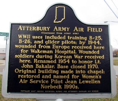
By Duane Hall, March 15, 2013
Atterbury Army Air Field Marker (Back)
| On Middle Rd at Grissom Ave, on the left when traveling north on Middle Rd. |
| On 5th Street at Franklin Street, on the right when traveling east on 5th Street. |
| On Washington Street south of 3rd Street, on the right when traveling south. |
| On Jackson Street south of 3rd Street (State Road 46), on the left when traveling south. |
| On Washington Street south of 3rd Street (State Road 46), on the right when traveling south. |
| On Jackson Street south of 3rd Street (State Road 46), on the left when traveling south. |
| On Jackson Street south of 3rd Street (State Road 46), on the left when traveling south. |
| On Jackson Street just south of 7th Street, on the right when traveling south. |
| On 5th Street at Franklin Street, on the right when traveling east on 5th Street. |
| On 5th Street at Lafayette Avenue, on the left when traveling west on 5th Street. |
| On County Road 325W at Lowell Rd, on the right when traveling north on County Road 325W. |
| On 17th St at Orinoco Ave, on the right when traveling west on 17th St. |
| On 3rd Street (Indiana Route 46) west of Lafayette Avenue, on the right when traveling west. |
| On North Gladstone Avenue 0.1 miles north of 7th Street, on the right when traveling north. |
| On County Road 500 North at North 100 East, on the right when traveling east on County Road 500 North. |
| On Reed St at 9th St, on the right on Reed St. |
| On Lindsey Street, on the right when traveling south. |
| On 3rd Street (State Road 46) at Jackson Street, on the left when traveling west on 3rd Street. |
| On 10th Street at Reed Street, on the right when traveling east on 10th Street. |
| On 3rd Street at Jackson Street, on the left when traveling west on 3rd Street. |
| On Jonesville Road (State Highway 11) at Spears Street, on the right when traveling north on Jonesville Road. |
| On 2nd Street at Railroad Rd, in the median on 2nd Street. |
| Near E. Harrison St (State Road 46) at N. Jackson St. |
| On E. Harrison St (State Road 46) at N. Jackson St, on the right when traveling west on E. Harrison St. |
| On E. Harrison St (State Road 46) at N. Washington St, on the right when traveling west on E. Harrison St. |
| On Indiana Route 9 at North County Road 300, on the right when traveling south on Indiana Route 9. |
| On Indiana Route 135 north of Route 45, on the right when traveling north. |
| On State Road 46 at T C Steele Road, on the right when traveling east on State Road 46. Reported missing. |
| On North Van Buren Street (Indiana Route 135) at East Main Street, on the left when traveling south on North Van Buren Street. |
| On East Main Street east of Van Buren Street (State Road 135), on the left when traveling east. |
| On East Main Street east of State Road 135, on the left when traveling east. |
| On South Van Buren Street (Indiana Route 135) south of East Main Street, on the left when traveling south. |
| On South Van Buren Street (Indiana Route 135) just south of West Main Street, on the right when traveling south. |
| On South Jefferson Street at West Main Street, on the right when traveling south on South Jefferson Street. |
| On East Main Street at North Van Buren Street, on the right when traveling west on East Main Street. |
| On South Van Buren Street at West Main Street, on the right when traveling south on South Van Buren Street. |
| On Jefferson Street North at West Main Street, on the right when traveling west on Jefferson Street North. |
| On East Main Street at South Van Buren Street ( Route 135) on East Main Street. |
| On West Main Street at South Jefferson Street, on the left when traveling west on West Main Street. |
| Near Abe Martin Lodge Road east of Brown County State Park Road, on the right when traveling east. |
| Near Abe Martin Lodge Road 2 miles south of Road 46, on the right when traveling north. |
| On West Street north of Summit Street, on the right when traveling north. |
| Near Market Street at E. Main Street, on the left when traveling north. |
| On Trail #7 east of State Park Drive, on the right when traveling north. |
| On Trail #7, on the right when traveling north. |
| On Trail #7 east of State Park Drive, in the median. |
| On Main Street west of Madison Street, on the right when traveling west. |
| On Jersey Avenue east of Ohio River Scenic Byway ( Road 62), on the left when traveling east. |
| On Main Street east of Main Cross Street, on the right when traveling east. |
| On Trail #7 east of State Park Drive, on the right when traveling south. |
| On Trail #7 east of State Park Drive, on the right when traveling south. |
| On Market Street (State Road 3) 0.2 miles south of Clark Road, on the right when traveling south. |
| On Trail #7 east of State Park Drive, on the right when traveling north. |
| On Trail #7 east of State Park Road, on the right when traveling east. |
| Near Jersey Avenue 1 mile south of Ohio River Scenic Byway ( Road 62), on the right when traveling south. |
| On Tunnel Mill Road, on the right when traveling south. |
| On Main Street at Short Street, on the left when traveling east on Main Street. |
| On Trail #7 east of State Park Drive, on the right when traveling north. |
| Near Patrol Road 0.7 miles north of Collector Wells Road, on the right when traveling north. |
| On Trail #7 east of State Park Drive, in the median. |
| Near an unnamed road 0.5 miles east of Jersey Avenue. |
| On Trail #7 east of State Park Drive, on the right when traveling north. |
| On Trail #7 east of State Park Drive, on the right when traveling north. |
| On Trail #7, on the right when traveling north. |
| On State Park Drive 0.1 miles east of Jersey Avenue, on the right when traveling east. |
| On Water Street at Harrison Street, on the right when traveling west on Water Street. |
| On Trail #7, on the right when traveling north. |
| On Trail #7 east of State Park Drive, on the right when traveling east. |
| On Trail #7 east of State Park Drive, on the right when traveling west. |
| On Trail #7 east of State Park Drive, on the right when traveling east. |
| On Trail #7 north of Jersey Avenue, on the right when traveling north. |
| On Trail #7 north of Jersey Avenue, in the median. |
| On West Harrison Avenue, on the right when traveling south. |
| On Harrison Avenue west of Lynda Avenue, on the left when traveling west. |
| On West Washington Street east of North Taggart Avenue, on the right when traveling east. |
| Near West Riverside Drive north of West Winbourne Avenue, on the left when traveling north. |
| On Ohio River Scenic Byway 0.4 miles west of Main Street, on the left when traveling west. |
| Near Harrison Avenue west of Bailey Avenue, on the right when traveling east. |
| On W. Winbourne Avenue at W Riverside Drive, on the right when traveling south on W. Winbourne Avenue. |
| Near West Riverside Drive north of West Winbourne Avenue, on the left when traveling north. |
| Near West Riverside Drive north of West Winbourne Avenue, on the left when traveling north. |
| Near Harrison Avenue west of Bailey Avenue, on the left when traveling west. |
| Near West Riverside Drive north of West Winbourne Avenue, on the left when traveling north. |
| On W. Winbourne Avenue at W Riverside Drive, on the right when traveling south on W. Winbourne Avenue. Reported missing. |
| Near Ohio River Scenic Byway 0.1 miles west of Main Street, on the left when traveling west. |
| On Zollman Road 0.4 miles east of Sunday Drive, on the left when traveling east. |
| On State Road 160 east of Interstate 65, on the right when traveling east. Reported missing. |
| On Winding Road 0.1 miles west of U.S. 31, on the left when traveling west. |
| Near Mulberry Street south of West Maple Street, on the left when traveling south. |
| On Patrol Road south of Trey Street, on the right when traveling south. |
| On Spring Street, on the right when traveling south. |
| Near Mulberry Street south of West Maple Street, on the left when traveling south. |
| Near Mulberry Street south of West Maple Street, on the left when traveling south. |
| On West Market Street at Mulberry Street, on the right when traveling east on West Market Street. |
| On East Park Place east of Crestview Court, on the right when traveling east. |
| On Mulberry Street south of West Chestnut Street, on the right when traveling south. |
| On East Court Avenue east of Watt Street, on the left when traveling east. |
| On W Riverside Drive at Clark Street, on the right when traveling east on W Riverside Drive. |
| Near Mulberry Street south of West Maple Street, on the left when traveling south. |
1434 entries matched your criteria. The first 100 are listed above.
Next 100 ⊳
