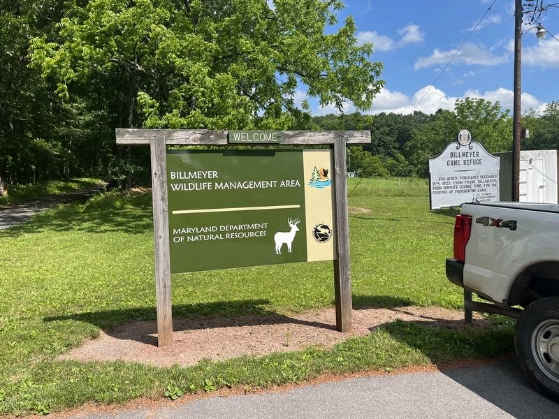
By Devry Becker Jones (CC0), June 12, 2022
Billmeyer Game Refuge Marker
GEOGRAPHIC SORT Title Sort Marker Number Sort Marker Number Sort for Trails Publication Order Sort Publication Order Sort A Erected Year Sort Most Viewed Sort Most Recent-Interest Sort Most Recently Changed Sort SEE FAQ #33 FOR DESCRIPTIONS
On Mountain Road 0.3 miles south of National Pike Northeast (Scenic U.S. 40), on the right when traveling east.
On Braddock Road (Maryland Route 49) at Greene Street (U.S. 220), on the left when traveling west on Braddock Road.
On National Highway (Alternate U.S. 40), on the right when traveling north.
On North Centre Street at Market Street, on the right when traveling west on North Centre Street.
On Washington Street at Prospect Square, on the left when traveling west on Washington Street.
On Evitts Creek Drive Southeast south of East Industrial Highway ( Route 51), on the right when traveling south.
On Greene St. at Washington Street on Greene St..
On Washington St. at Prospect Square, on the left when traveling west on Washington St..
On U.S. 220, on the right when traveling north.
On Historic National Road (Maryland Route 144) 0.2 miles east of Murley's Branch Road, on the right when traveling east.
On Mountain Road 0.2 miles south of National Pike Northeast (Scenic U.S. 40), on the right when traveling north.
On West Main Street (Alternate U.S. 40) at Chestnut Street, on the right when traveling east on West Main Street.
On New Georges Creek Road (Maryland Route 36) at Hoffman Hollow Road, on the right when traveling north on New Georges Creek Road.
On National Highway (U.S. 40) at Route 36, on the right when traveling east on National Highway.
Paid Advertisement
On Vocke Road (Maryland Route 53(658)) south of Exit 40 (Interstate 68).
On National Highway SW (U.S. 40), on the left when traveling west.
On National Highway (Alternate U.S. 40) west of Mary Court, on the left when traveling west.
On National Highway (U.S. 40) west of Mt. Savage Road NW ( Route 36), on the right when traveling east.
On Opessa Street at Green Spring Road, on the left when traveling east on Opessa Street.
On Oldtown Road (Maryland Route 51) at Opessa Street, on the right when traveling east on Oldtown Road.
On Ritchie Highway (Maryland Route 450) at Chase Road, on the left when traveling south on Ritchie Highway.
On State Circle near School Street.
On State Circle at Francis Street on State Circle.
On State Circle at North Street, on the left when traveling south on State Circle.
On 6th Street 0.2 miles south of Compromise Street, on the right when traveling south.
On Defense Highway (Maryland Route 450) 0.6 miles west of Housley Road, on the right when traveling west.
On Solomons Island Road (Maryland Route 2) 0.2 miles south of Sommerville Road, on the right when traveling north.
On Defense Highway (Maryland Route 450).
On Generals Highway (Maryland Route 178) at Defense Highway ( Route 450), on the left when traveling south on Generals Highway.
Paid Advertisement
On Reidel Road at Johns Hopkins Road, on the left when traveling south on Reidel Road.
On Generals Highway (Maryland Route 178) at Rockbridge Academy Belvoir Estate, on the left when traveling south on Generals Highway. Reported permanently removed.
On Generals Highway (Maryland Route 178) at Rockbridge Academy Belvoir Estate, on the right when traveling west on Generals Highway.
On Generals Highway (Maryland Route 178) just south of Sunrise Beach Road, on the right when traveling south.
On Old Davidsonville Road (Maryland Route 424) 0.5 miles south of John Hanson Highway (U.S. 50), on the right when traveling south.
On South River Clubhouse Road 0.8 miles east of Solomon’s Island Road ( Route 2), on the right when traveling east.
On Friendship Road (Maryland Route 261) 0.1 miles south of Fairhaven Road (Route 423), on the left when traveling south.
On Muddy Creek Road 0.1 miles east of Galesville Road, on the right when traveling east.
On Galesville Road 0.8 miles east of Muddy Creek Road ( Route 468).
On Dorsey Road (Maryland Route 176) east of Arundel Avenue, on the right when traveling east.
On Dorsey Road (Maryland Route 176) 0.7 miles west of Telegraph Road ( Route 170), on the right when traveling west.
On Dorsey Road (State Road 176) 0.1 miles west of Arundel Mills Blvd / New Ridge Road (State Road 713), on the right when traveling west.
On Solomon’s Island Road (Maryland Route 2) 0.5 miles south of Mill Swamp Road, on the left when traveling south.
On Solomons Island Road (Maryland Route 2) at Harwood Road, on the left when traveling south on Solomons Island Road.
On Solomon’s Island Road (Maryland Route 2) 1 mile north of Harwood Road, on the right when traveling north. Reported missing.
On N. Camp Meade Rd (Maryland Route 170) 0.1 miles north of Maple Road. Reported missing.
Paid Advertisement
On Camp Meade Road (Maryland Route 170) at Maple Road, on the right when traveling south on Camp Meade Road.
On Greenock Road (Maryland Route 259) at Southern Maryland Boulevard ( Route 4), on the right when traveling north on Greenock Road.
On Solomons Island Road (Maryland Route 2) 0.3 miles north of Bay Front Road ( Route 258), on the right when traveling north.
On Benfield Boulevard 0.1 miles east of Veterans Highway, on the right when traveling east.
On Veterans Highway 0.4 miles south of Benfield Road, on the right when traveling south.
On Veterans Highway 0.5 miles south of Benfield Road, on the left when traveling south.
On Generals Highway (Maryland Route 178) at Indian Landing Road, on the right when traveling south on Generals Highway.
On Veterans Highway 0.5 miles south of Benfield Road, on the left when traveling south.
On Odenton Road at Morgan Road, on the right when traveling east on Odenton Road.
On Waco Avenue south of Odenton Road, on the right when traveling north.
On Mountain Road (Maryland Route 177/648) 0.1 miles east of Freetown Road, on the right when traveling west.
On Mountain Road (Maryland Route 177) 0.2 miles west of Magothy Bridge Road ( Route 607), on the left when traveling west.
On WB&A Road at Donaldson Avenue ( Route 174), on the right when traveling north on WB&A Road.
On Governor Stone Parkway at Benfield Boulevard, on the right when traveling north on Governor Stone Parkway.
On Ritchie Highway (Maryland Route 2) 0.2 miles south of Jones Station Road, on the right when traveling south. Reported missing.
On Solomon’s Island Road (Maryland Route 2) at Brick Church Road, on the right on Solomon’s Island Road.
Paid Advertisement
On Owensville Road (Maryland Route 255) at Muddy Creek Road ( Route 468), on the left when traveling east on Owensville Road.
On West Baltimore Street.
On Dundalk Avenue at Chandlery Street, on the right when traveling south on Dundalk Avenue.
On O’Donnell Street at Potomac Street, in the median on O’Donnell Street.
On Frederick Avenue (Maryland Route 144) at Font Hill Avenue, on the right when traveling west on Frederick Avenue.
On Warren Street at Henry Street, on the right when traveling west on Warren Street.
On North Charles Street at University Parkway on North Charles Street.
On Falls Road (Maryland Route 25) 0.1 miles south of 36th Street, on the right when traveling south.
On Charles Street (Maryland Route 139) at Greenway, on the right when traveling south on Charles Street.
On East Pratt Street at President Street, on the left when traveling east on East Pratt Street.
On Fort Avenue at Towson Street, on the right when traveling east on Fort Avenue.
On East Cold Spring Lane.
On Kelly Avenue at Bonnieview Avenue, on the right when traveling west on Kelly Avenue.
On Parkside Drive at Boehms Lane on Parkside Drive.
Paid Advertisement
On East Randall Street at Riverside Avenue, on the right when traveling east on East Randall Street.
On West 40th Street at Keswick Road, on the right when traveling west on West 40th Street.
On Roland Park Avenue at Upland Road, on the left when traveling north on Roland Park Avenue.
On Eislen Street at Camden Street on Eislen Street.
Near Howard Street south of West Camden Street, on the right when traveling south.
On West Hamburg Street at Russell Street when traveling east on West Hamburg Street.
On Lombard Street at Greene Street, on the right when traveling west on Lombard Street.
On North Broadway 0.1 miles south of Fayette Street, on the right when traveling south.
On Waterview Avenue 0 miles west of Annapolis Road ( Route 648), on the right when traveling east.
On Sweet Air Road (Maryland Route 145) 0.1 miles east of Manor Road, on the right.
On Pleasantville Road at Fork Road / Baldwin Mill Road, on the right on Pleasantville Road.
On Ruxton Road (Maryland Route 133) at Falls Road ( Route 25), on the left on Ruxton Road.
On Bloomsbury Avenue south of Bloomingdale Avenue, on the left when traveling north.
Paid Advertisement
On Frederick Road, on the right when traveling west.
On Frederick Road at North Beaumont Avenue, on the left when traveling east on Frederick Road.
On Frederick Road (Maryland Route 144) at Rolling Road ( Route 166), on the right when traveling west on Frederick Road.
On Shawan Road at Western Run Road, on the right when traveling west on Shawan Road.
On North Point Road (Maryland Route 20) at Kimberly Road, on the right when traveling south on North Point Road.
︽
650 entries matched your criteria. The first 100 are listed above.
Next 100 ⊳