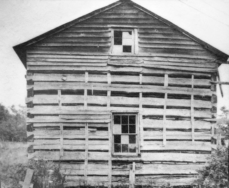
More than a century ago, log cabins were a common sight in Appalachia and in other rural areas of the eastern United States. Samuel and Elizabeth Matthews built this cabin near Galax in 1869. Made largely of oak, it has one room on each of its two . . . — — Map (db m174592) HM
Simon the tanner used this horse-powered machine to grind oak and hemlock bark for tanning. Mixed with water this ground bark produced “bark liquor” for “tanning hides.” — — Map (db m174587) HM
Rarely seen today, the blacksmith shop was a vital home industry in Ed Mabry’s time. Here “Uncle Ed” cleverly fashioned wagon tires, andirons, tools, and various other iron objects for himself and his neighbors. — — Map (db m174591) HM
Although operating a mill was never easy, Ed Mabry faced special challenges. For one, the quantity of running water, which turned the overshot wheel and powered all the equipment in the mill, was barely adequate. To increase his supply, Mabry built . . . — — Map (db m174583) HM
Take one hollow log “Ash Hopper” filled with ashes. Filter water through ashes to produce lye. Add old fat to lye solution and boil in iron pot. The result: homemade soap. — — Map (db m174590) HM
Freshly sawed lumber must be dried evenly to prevent warping and checking. Ed Mabry used a rack similar to this for drying lumber. — — Map (db m174586) HM
This mill was built about 1910 by Edwin B. Mabry, a jack-of-all-trades who had been a chairmaker, a miner, a coal company blacksmith, and a farmer. He and his wife, Mintoria Lizzie Mabry, operated the mill until 1936, grinding corn and sawing lumber . . . — — Map (db m165417) HM
These stones are from a quartz conglomerate obtained at Brushy Mountain Quarry, Blacksburg, VA. They were shaped at the quarry, but the miller “dressed” or sharpened them with homemade “chisels.” — — Map (db m174584) HM
Down this path you will find buildings,
farm implements and other displays that
document rural life in Appalachia over
a period of about 100 years. Most were
restored and arranged here during the
1940s and 1950s.
These displays illustrate . . . — — Map (db m11083) HM
Making sorghum molasses became popular during the Civil War, when supplies of sugar and corn syrup were interrupted. The practice continues today in many communities, where the sweet smell of boiling sorghum can be enjoyed in the cool October air. . . . — — Map (db m174589) HM
Many settlers and early residents brought with them the knowledge and the custom of making whiskey. Although tax laws and, for a while, Prohibition made the activity illegal, moonshiners have always operated in the mountains and other areas of the . . . — — Map (db m174588) HM
CARROLL COUNTY
Area 458 Square Miles
Formed in 1842 from Grayson, and named for Charles Carroll of Carrollton, signer of the Declaration of Independence. New River runs through this county.
FLOYD COUNTY
Area 376 Square . . . — — Map (db m206711) HM
This is a drawing of the water system used on Mr. Hurley Hampton's farm from 1890 to 1914. The spring is down the hill 100 feet below the house. By cranking the windlass, the bucket was lowered into the soapstone basin, dipping up a bucket of . . . — — Map (db m305026) HM
Carroll County Area 458 Square Miles. Formed in 1842 from Grayson, and named for Charles Carroll of Carrollton, signer of the Declaration of Independence. New River runs through this county.
Grayson County Area 425 . . . — — Map (db m182119) HM
If you own wooden or upholstered furniture that is less than 100 years old, it may have been made in Galax.
Taking Advantage of Local Resources
The connection between furniture and Galax was established early in the city's history. One . . . — — Map (db m305024) HM
Galax. Much of America’s music was invented in Virginia, and Galax and surrounding communities have long been an epicenter for the keeping of historic sounds and the creation of new ones. Greenberry Leonard lived in the Old Town section of . . . — — Map (db m68284) HM
The town is on the dividing line between Grayson and Carroll Counties. Its original name was Bonaparte, which was changed to Galax, the name of a mountain shrub abundant in the vicinity. In 1904 a spur of the Norfolk and Western Railroad came here, . . . — — Map (db m65678) HM
Don't be surprised if you hear the sweet strains of fiddle or the lively licks of some mean guitar pickin’ while you are in Galax. Folks around here take pride in Galax’s place in the world of traditional mountain music.
Galax: At the Center of . . . — — Map (db m65669) HM
“Forged by mountains, river and America's desire for progress, the 57-mile New River Trail State Park provides you unparalleled opportunities for physical, intellectual and spiritual adventures."
As you stand here, with cars rushing by you, imagine what the roads in the Galax area must have been like when the City was incorporated in 1906. There were very few roads, and those that did exist were little more than muddy ruts.
Thinking . . . — — Map (db m65683) HM
Giles County. Area 369 square miles. Formed in 1806 from Montgomery, Tazewell, and Monroe, and named for William B. Giles, United States Senator and Governor of Virginia, 1827-1830. Mountain Lake is in this county.
Bland . . . — — Map (db m99261) HM
Near here Adam Harmon, probably in 1750, established what is believed to be the first settlement in Giles County. Here, in 1755, he found Mary Ingles as she was making her way back to Draper's Meadows after her escape from the Indians. — — Map (db m41427) HM
West Virginia. West Virginia was long a part of Virginia. Morgan Morgan began the settlement of the region in 1727. A great battle with the Indians took place at Point Pleasant in 1774. West Virginia became a separate state of the Union in . . . — — Map (db m34767) HM
Giles County. Formed in 1806 from Montgomery, Tazewell and Monroe, and named for William B. Giles, United States Senator and Governor of Virginia, 1827–1830. Mountain Lake is in this county.
West Virginia. West Virginia was long a . . . — — Map (db m84134) HM
Named for the narrows in New River. The place was occupied by Confederate troops under French and Jackson in May, 1864. Combining with McCausland, they forced the Union General Crook to evacuate Blacksburg. Crook passed here on his way to West . . . — — Map (db m84143) HM
The New River is estimated to be more than 100 million years old, making it one of the oldest rivers in the world. It is a remnant of the prehistoric Teays River. The first written documentation of the New River was by explorers Thomas Batte and . . . — — Map (db m84135) HM
We honor
those who served
A tribute to the veterans of the Town of Narrows who gave their lives in the wars of our country
World War I
Robert H. Hale •
Samuel E. Johnson •
Herbert W. Morris
World War II . . . — — Map (db m305324) WM
1829
Andrew Johnston
House
has been placed on the
National Register
of Historic Places
by the United States
Department of the Interior — — Map (db m305323) HM
Giles County was formed from Montgomery, Monroe (now in West Virginia), and Tazewell Counties in 1806. It was named for William Branch Giles, United States senator from Virginia and later governor. North of here, the first court of Giles County was . . . — — Map (db m37528) HM
(Side 1)
1861-1865
To the Confederate soldiers of Giles County
Our Heroes
(Side 2)
Giles Co. furnished seven volunteer companies numbering about 800 men as follows:
Co D 7th Regiment Infantry
" F 24 " "
" H 36 " "
" . . . — — Map (db m162889) WM
(side 1)
Honor Roll
1917—1919
In memory of the men of Giles County who gave their lives in defense of their country in the World War.
Charles B. Davis • Leonard C. Duncan • W. Kyle Echols • Otey H. Elmore • Elcana J. . . . — — Map (db m162885) WM
These Grist Mill stones are from the Dave Bolton Mill
Kimbalton, Virginia Circa 1850
(Later known as the Kimball Mill)
Courtesy of Mrs. Norweta Wilburn
The mill was located near Caldwell's Store (1901-26) and the Kimballton Post Office. . . . — — Map (db m304966) HM
The town was laid off in 1806 when Giles County was formed, and named for Captain George Pearis, early settler. Established in 1808, it was first incorporated in 1835, and reincorporated in 1914. Here, in May 1862, Union troops under Colonel . . . — — Map (db m34811) HM
James Adair • Jacob Albert • John Alsup • Hezekiah Atkins • Milliton Atkins • Parker Atkins • James Bane Jr. • William Bradley • Lowe Brown • William Brown • Humphrey Brumfield • James Brumfield Jr. • James Brumfield Sr. • John Burke • Capt. . . . — — Map (db m162874) WM
This stepping stone was originally at the Pearisburg livery stable and was used to step from or to a horse or carriage onto the landing without soiling your shoes. The stable was located on the west side of the intersection of Mountain Lake . . . — — Map (db m305290) HM
A Revolutionary War soldier, was buried near this site in 1796. His services, extending over twenty years, include:
1758 French and Indian Wars
1774 Battle of Point Pleasant
1776 Erected Farley's Fort, near the New River.
1778 Fought in . . . — — Map (db m305072) HM
Near here is the original site of C.C.C. Company 1370-2386, known as Camp John J. Pershing, from 1933 to 1935, when it was moved to Nottoway County. Among the most popular New Deal programs, the Civilian Conservation Corps was designed to encourage . . . — — Map (db m34828) HM
To the sacred memory of
John-Jacob and Elizabeth (Helm) Snidow and their children: Barbara, Philip, Christian, Jacob, John, Theophilus and
two daughters.
John-Jacob, of Lancaster County, Pennsylvania, visited this vicinity ca. 1766. He went . . . — — Map (db m162890) HM
Jefferson National Forest
Not so long ago, in 1965, the Forest Service purchased the Cascades. A trail was built to finally open the falls to the public.
What is that thing?
This is the old boiler that provided power necessary to . . . — — Map (db m305073) HM
Giles County. Area 369 square miles. Formed in 1806 from Montgomery, Tazewell, and Monroe, and named for William B. Giles, United States Senator and Governor of Virginia, 1827-1830. Mountain Lake is in this county.
Pulaski . . . — — Map (db m41442) HM
The Reverend Robert Sayers Sheffey (1820-1902), although one of a kind as to style and personality, was a Methodist Circuit Rider in the classic frontier tradition. Celebrated for the intensity of his faith and prayer, as well as for his . . . — — Map (db m41428) HM
Adjacent to and named for this stream, Wabash Campground was exemplary of a religious and social institution, indeed of a way of life, which flourished during the 19th century. Hundreds of families would camp for two weeks or more while attending . . . — — Map (db m41429) HM
Nearby was the home of James and Lovice Sage, whose five-year-old daughter Caty was abducted in 1792. Fifty–six years later her brother Charles located her in eastern Kansas after a Wyandots Indian told him that a woman named Yourowquains, with . . . — — Map (db m65758) HM
Bork in Elk Creek, Virginia, June 29, 1821, member of the House of Delegates, 1874–1877, member state Senate, 1879-1882. One of the “Big Four,” a group which resisted many proposals of the Readjusters. Died in Elk Creek, December . . . — — Map (db m65760) HM
The original “New River Train” song was claimed
by the Ward family of Galax as part of their
repertoire as early as 1895. The song was believed
to refer to the train that ran on the New River
Line in 1883 as part of the Norfolk and . . . — — Map (db m65723) HM
Fries is named for Colonel Francis H. Fries of
North Carolina, founder of the Washington
Mills Company. By 1900, Fries and his
associates had determined that the New River
could power a textile mill. The town was
incorporated in 1902, and by . . . — — Map (db m65695) HM
On 10 Dec. 1923, millhand Henry Whitter of
Fries, Virginia, recorded nine songs in New York
City for OKeh Records. Released early in 1924,
the coupling of “Wreck on the Southern Old 97”
and “Lonesome Road Blues” became one of the
first . . . — — Map (db m65717) HM
Virginia's New River Trail stretches 57 scenic miles along a prehistoric, mountain-sided channel, traveled through the ages by a north-flowing river, countless wild species, Native Americans, early settlers, and the railroad whose bed composes . . . — — Map (db m306218) HM
America's commercial country music began in a cotton mill in Fries in 1923. Mill hand Henry Whitter traveled to New York and recorded a hit, "The Wreck of the Old '97". In 1924 a second mill hand, Ernest V. Stoneman, went north to record. They were . . . — — Map (db m208656) HM
Grayson County Virginia. Area 425 square miles. Formed in 1792 from Wythe. Named for William Grayson, one of the firsrt two United States Senators from Virginia. Headwaters of the New River are in this county.
North . . . — — Map (db m104660) HM
Grayson County, formed in 1792 from Wythe County, was named for William Grayson, one of Virginia's first two United States senators. Its court initially met at William Bourne's farm near present-day Fries. Here at Old Town, earlier known as . . . — — Map (db m182112) HM
Riverhill Baptist Church, 2.5 miles northwest, is among the region's oldest African American congregations. Emancipated people founded Riverhill between 1868 and 1873, aided by the missionary efforts of local White Baptists who had supported the . . . — — Map (db m304879) HM
Grayson County Courthouse
has been registered as a
Virginia Historic Landmark
pursuant to the authority vested in the
Virginia Historic Landmarks Commission Act of 1966 — — Map (db m158005) HM
Grayson County, VA.
In memory of
those who paid the Supreme Sacrifice
in World Wars I and II
World War I
Lee Adams • John A. Farmer • Estell L. Kiser • Guy Richardson • Warrick Anders • Everett M. Guynn • Posey L. Lamkin • Munsey . . . — — Map (db m158002) WM
[side 1]List of persons who hath sworn allegiance to the State in 1777 We whose names are hereunto subscribed to swear or affirm that we renounce and refuse all allegiance to George III, King of Great Britain, his heirs and successors, . . . — — Map (db m174491) WM
Independence. Grayson County is noted for traditional music and altitude. Four of Virginia’s five highest mountains are to be found here. In 1850 Grayson County was in the midst of controversy concerning the location of the county seat. As a . . . — — Map (db m72616) HM
This place became the county seat of Grayson County in 1850; the first case was tried in the newly erected courthouse in 1851. The present courthouse was built in 1908. Independence was incorporated in 1934. — — Map (db m65763) HM
Grayson County Board of Supervisors Brenda R. Sutherland — Chair • Elk Creek District Kenneth R. Belton — Vice Chair • Old Town District Michael S. Hash • Providence District G. Eddie Rosenbaum • Wilson District John S. Fant • At-large . . . — — Map (db m174489) HM
Grayson County. Western Grayson County has produced fine traditional musicians, performers at school entertainments, fiddlers’ conventions, and community gatherings for many generations. Among them was the old-time string band, the Rugby Gully . . . — — Map (db m70778) HM
Designed and pioneered in the 1890’s. First manufactured by John Deere in 1911, commonly known as a “horse drawn hay” mowing machine. — — Map (db m307968) HM
This log cabin was originally built by the Pendry family on nearby Shippies Branch. It was moved into the park in 1973 and restored. The oak logs and natural stone chimney have been chinked with clay and the roof is of hand-rived oak shingles. The . . . — — Map (db m162835) HM
The land where the picnic and cabin areas are today was once the homestead of William Marshal Jones and his family. Their homesite was adjacent to the creek, just across the old stone bridge. William Jones and his wife, Eunnace Phipps, were married . . . — — Map (db m162845) HM
This trail goes .6 mile along Rock House
Ridge to a meadow offering a view of the
Mill Creek and Rugby areas. The trail then
loops back to the homestead area where
there are several log cabins and outbuildings
from the late 1800s and the early . . . — — Map (db m162839) HM
This cabin was originally located on park property south of Route 58. It is named after William Glen and Hester Spencer, who lived in it from 1936 until Hester's death in 199O.
Spencer Cabin was built by John Calvin Ingram in the early 1900's. . . . — — Map (db m162843) HM
Early settlers used a very simple, effective way to refrigerate vegetables and dairy products... the cold, sweet waters of an underground spring.
Coming from deep within the mountains, the cold water ran constantly even during the hot summer . . . — — Map (db m162842) HM
The logs in this cabin were taken from one built by Grant Weaver near Mud Creek in 1902. It is believed that Mr. Weaver took some of the logs from another older dwelling and that this lumber is 150 years old.
The cabin is constructed mainly of . . . — — Map (db m162840) HM
The Abingdon Branch of the Norfolk & Western
Railway was nicknamed the “Virginia Creeper,”
likely for the train’s slow speed through this
mountainous region. Initially chartered by the
Abingdon Coal & Iron Railroad in 1887, little construction . . . — — Map (db m65773) HM
The national demand for commercial Christmas trees has brought a new look to the highest mountains of Virginia, Tennessee and North Carolina. Billion of dollars worth of Fraser Fir (Abies fraseri) plantations produce regular crops of Christmas trees . . . — — Map (db m72520) HM
Here you see something like the old growth forest that grew along all these upper slopes, some of the last old growth cut in eastern North America. The largest mature yellow poplar trees (Liriodendron tulipifera) and hemlock (Tsuga . . . — — Map (db m211208) HM
From the Blue Ridge Mountains to the Coalfields region, southwest Virginia is blessed with historic and contemporary music venues, musicians, and fretted instrument makers. Historically isolated, the region retained its strong musical legacy by . . . — — Map (db m307971) HM
Just a few hundred feet west of this point is an odd corner in the state line between Tennessee and Virginia, part of an error in the state boundary line that extends a "point" of Tennessee into Virginia for a short distance. The original surveying . . . — — Map (db m211089) HM
This is one of several trestle bridges along the Virginia Creeper Trail. The original railroad required over 100 bridges, mostly made of wood. When the railroad was being constructed in the period 1900 - 1912, these structures were more practical . . . — — Map (db m211082) HM
The White Top Folk Festival was held annually
from 1931 to 1939, (except 1937) on Whitetop
Mountain—the second highest peak in Virginia.
Annabel Morris Buchanan, John Powell, and
John A. Blakemore organized the event that featured banjo . . . — — Map (db m65774) HM
Whitetop, Mt. Rogers. Visible at great distances, Whitetop Mountain was known as the “Meadow Mountain” in colonial times. With a climate similar to southern Canada, this beloved mountain is Virginia’s second highest peak and immediately . . . — — Map (db m71555) HM
Stretching over 2,180 miles, the Appalachian Trail (A.T.) crosses 14 states, five national parks, seven national forests, and numerous state parks and towns between Maine and Georgia. A physically daunting task, the climbing required in hiking the . . . — — Map (db m108477) HM
Greene County. Formed from Orange County in 1838, this rural Piedmont county was named for Gen. Nathanael Greene, Revolutionary War military hero. The county seat of Greene County is Stanardsville. William Donoho and William B. Phillips, . . . — — Map (db m21505) HM
Orange County. Formed from Spotsylvania County in 1734, Orange County, a pastoral Piedmont county, was probably named in honor of William IV, the Dutch prince of Orange, who married Anne, the Princess Royal, daughter of George II of England, . . . — — Map (db m24228) HM
A descendant of the Huguenot immigrant Peter Rucker, John Rucker (d. 1794) settled east of here on Rippin’s Run, and built Friendly Acres, the first of many Rucker family dwellings in the area. He founded the village of Ruckersville, naming it for . . . — — Map (db m262198) HM
Built in 1934, the house and surrounding 39-acre family farm were home to John Emmons Taylor, his wife Louise Jennings Taylor, and their two daughters, Elizabeth and Alice. The Taylors were recognized active members of the community and faithful . . . — — Map (db m170176) HM
The Episcopal Church opened Blue Ridge School
here in 1910 for children from mountain communties who had minimal access to education. Led by
the Rev. George P. Mayo, the school became the
centerpiece of an extensive network of Episcopal
missions . . . — — Map (db m234291) HM
The village of Stanardsville was founded by William Stanard (died 1807), of Roxbury plantation, on land that was part of his 6,000 acre inheritance from the Octonia Grant of 1729. This grant included most of what is presently northern Greene County . . . — — Map (db m22988) HM
Near this site on 1 Mar. 1864, Maj. Gen. J. E. B. Stuart's Confederate cavalry engaged Brig. Gen. George A. Custer's Union cavalry in what is called locally the Battle of Stanardsville. To divert Stuart from Richmond, Custer led his troopers down . . . — — Map (db m22985) HM
This coal car was one of many that were hoisted in and out of the mine. These cars were pulled by a hoist system. The cars were built with a low profile so that they could fit deep in the mine to be loaded without having to move the coal to the car . . . — — Map (db m95441) HM
The coal car hoist was the force that pulled the cars out of the mine. Each hoist used a large winch-like structure that was originally powered by steam. The picture you see below is of two miners being pulled out of the mine by the hoist system. — — Map (db m95445) HM
Here was the first foundation that pulled the coal cars from the mine. This foundation held the hoist that worked in sequence with a series of hoists to move the coal. The foundations are still here to this day because of the force that was put on . . . — — Map (db m95440) HM
Price's Fork is within the area often referred to as the German New River Settlement. Before 1745, German immigrants moved from Pennsylvania and began settling in this region within the Price's Fork-Tom's Creek area near and along the horseshoe . . . — — Map (db m42850) HM
The Commissary building was located here and served the community for their groceries as well as everyday household supplies. These concrete piers once supported the loading platform and post office that were in this building. The Commissary was . . . — — Map (db m95439) HM
Here remain just a few bricks and concrete that made the foundations of the hotel. This hotel was a large two-story boardinghouse for unmarried miners, new employees and visitors to the mines. The hotel also featured a single-story porch across the . . . — — Map (db m95438) HM
Here was the center of the entire Merrimac community: the Tipple was the largest and most prominent building here. Reaching 100 feet high, the Tipple was the loading station for the train, the Huckleberry. The Huckleberry would run directly through . . . — — Map (db m95443) HM
Five miles south lies the main campus of Virginia Polytechnic Institute and State University, founded in 1872 as a land-grant college specializing in agriculture and mechanical arts. The land-grant college system initiated scientific agricultural . . . — — Map (db m37520) HM
This elaborate Queen Anne Victorian home was built by Alexander Black, a great nephew of Blacksburg's founder, William Black. Alexander was also a prominent businessman who established the National Bank of Blacksburg in 1891, serving as its . . . — — Map (db m292760) HM
The Blacksburg Motor Company building was built by Robert and Mason Heavener, two well-respected Blacksburg businessmen. Robert Heavener was a prominent citizen serving on Town Council and the National Bank of Blacksburg Board of Directors. . . . — — Map (db m84769) HM
734 entries matched your criteria. Entries 101 through 200 are listed above. ⊲ Previous 100 — Next 100 ⊳