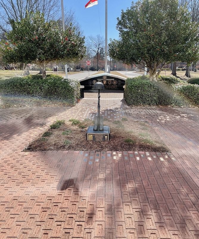
Front:
Dedicated in remembrance of
SSG Jonathan Kilian Dozier, USA
Hammer Company, 3rd Squadron,
2D Stryker Calvary Regiment
Sinsil, Iraq 09 January 2008
and to all who have given the
“Last Full Measure”
in . . . — — Map (db m191539) WM
On Bells Mills Road at Progress Drive, on the left when traveling west on Bells Mills Road.
This memorial is the first and only memorial of its kind in the Commonwealth of Virginia dedicated to honor Afro-Union patriot heroes. It is located in the northeast section of the Sgt. March Corprew Family Memorial Cemetery.
Sgt. March . . . — — Map (db m211252) HM
On Mt. Pleasant Road (County Route 165) near Woodford Drive, on the right when traveling south.
In 1906, Norfolk County built a four room brick school house, “The Great Bridge School”, to educate elementary and high school students. Graduating its first class in 1911, the name was changed to Great Bridge High and Grammar School . . . — — Map (db m113684) HM
Near City Park Drive at Greenbrier Road, on the left when traveling west.
Day of Remembrance
In the years following the 9/11 attacks, the City of Chesapeake has hosted Day of Remembrance ceremonies at Chesapeake City Park to remember those who perished on September 11th, to honor those who protect and defend our . . . — — Map (db m191844) HM WM
Near City Park Drive at Greenbrier Road, on the left when traveling west.
Transporting the Artifacts
Following the September 11 attacks, crews of public safety officials and volunteers spent nine months clearing 1.8 million tons of debris at Ground Zero. Artifacts from the World Trade Center complex were . . . — — Map (db m191874) HM WM
Near City Park Drive at Greenbrier Parkway, on the left when traveling west.
New York City
The original One World Trade Center, also known as the North Tower, was completed in 1972 and stood at an impressive height of 1,730 feet. The design featured a telecommunications antenna on the roof of the structure, making . . . — — Map (db m191857) HM WM
Near North Battlefield Boulevard (Business Virginia Route 168) at Watson Road, on the left when traveling south.
In late October 1775, the Virginia Committee of Safety ordered Colonel William Woodford and his 2nd Virginia Regiment, along with five companies of Culpeper Minutemen, to march towards Norfolk and protect “…all friends to the American cause.” The . . . — — Map (db m211241) HM
Near Watson Road at North Battlefield Boulevard ( Route 168), on the left when traveling south.
(side 1)
This monument honors
Patriots who assembled
at this site in the Cause of
American Freedom in 1775
American Patriots
at the Battle
Second Virginia Regiment
Commanded by
Colonel William Woodford,
of . . . — — Map (db m211239) HM
Near North Battlefield Boulevard (Business Virginia Route 168) at Watson Road, on the left when traveling south.
His courage “amid a shower of bullets” helped achieve victory at the Battle of Great Bridge.
Private William (Billy) Flora was a free black from the Portsmouth area and a member of the Norfolk County Militia who served as a . . . — — Map (db m54952) HM
Near Locks Road 0.6 miles west of North Battlefield Boulevard ( Route 168), on the left when traveling west.
1600s: Woodlands, Marshes and the Great Bridge
The rich forests and fields south of the Elizabeth River and in northeastern North Carolina gave the early settlers in the late 1600s bountiful yields of shingles, naval stores, lumber, grain . . . — — Map (db m211244) HM
Near North Battlefield Boulevard (Business Virginia Route 168) at Watson Road, on the left when traveling south.
Some areas of the marsh were high enough to allow crossing on a corduroy road made of logs. Lower areas of the marsh required a stronger infrastructure, like the one seen here. This exhibit illustrates how five or six timbers, each ranging from 15 . . . — — Map (db m54950) HM
Near North Battlefield Boulevard (Business Virginia Route 168) at Watson Road, on the left when traveling south.
“There is great want of a bridge for horse and man over the swamp at the head of the Southern Branch of Elizabeth River…” Norfolk County Deed Book 5, part 2, Orders. page 4, 1686
In the mid-1600s, as the early settlers began to . . . — — Map (db m54948) HM
Near North Battlefield Boulevard (Business Virginia Route 168) at Locks Road, on the right when traveling south.
This 7,900-pound anchor was manufactured in 1861 by the Naval Yard Foundry in Washington, D.C., and most likely belonged to the USS Hartford, a Union warship immortalized at the Battle of Mobile Bay on August 5, 1864, when Admiral David Glasgow . . . — — Map (db m54957) HM
Near North Battlefield Boulevard (Business Virginia Route 168) at Locks Road, on the right when traveling south.
Marshall Parks, Sr.
1786-1840
The Dismal Swamp Canal, located about six miles west of here, officially opened in 1805. Dug completely by hand, its shallow depth limited navigation to flat boats and lighters manually poled or towed from . . . — — Map (db m54956) HM
Near North Battlefield Boulevard (Business Virginia Route 168) at Watson Road, on the left when traveling south.
At daybreak on the morning of December 9, 1775, the British rolled two four-pounder cannon field pieces across the bridge under the cover of smoke from burning buildings and piles of shingles located on the south island. The fires were set by . . . — — Map (db m54947) HM
Near North Battlefield Boulevard (Business Virginia Route 168) at Watson Road, on the left when traveling south.
By the summer of 1775, British control over the Colony of Virginia was in peril and Dunmore looked to Norfolk, the most heavily populated town in Virginia and the largest seaport between New York and Charleston. The occupation of Norfolk and Hampton . . . — — Map (db m54941) HM
Near North Battlefield Boulevard (Business Virginia Route 168) at Watson Road, on the left when traveling south.
Fauquier County, Virginia
Officers of the Culpeper Minute Battalion
At the Battle of Great Bridge
Major Thomas Marshall (1730-1802)
Member, 1st, 2nd, 3rd & 4th Virginia Conventions
Colonel, 3rd Virginia Regiment
Colonel, Virginia . . . — — Map (db m54953) HM
Near North Battlefield Boulevard (Business Virginia Route 168) at Watson Road, on the left when traveling south.
“…to reduce this colony to a proper sense of their duty…to His Majesty’s crown and dignity…”
On November 15, 1775, the day after his success in routing the rebels at Kemp’s Landing, Lord Dunmore issued a proclamation declaring . . . — — Map (db m54942) HM
Near Locks Road 0.6 miles west of North Battlefield Boulevard ( Route 168), on the left when traveling west.
The Canal Becomes a Federal Government Waterway
Competition from the railways and the re-structured Dismal Swamp Canal Company signaled the downfall of the Albemarle and Chesapeake Canal Company in 1910. By 1913, Congress, recognizing the . . . — — Map (db m48964) HM
On North Battlefield Boulevard (Virginia Route 168) at Great Bridge Boulevard ( Route 190), on the right when traveling south on North Battlefield Boulevard.
A direct outgrowth of the New Mill Creek Society organized in 1772 by the Rev. Joseph Pilmoor, the first official Methodist missionary to America. Methodist meetings were held as early as 1770 in the Cutherell home, a regular preaching place for . . . — — Map (db m48923) HM
Near North Battlefield Boulevard (Business Virginia Route 168) at Watson Road, on the left when traveling south.
The Albemarle & Chesapeake Canal did not exist at the time of the Battle of Great Bridge…
...but plans for a canal at Great Bridge were in place more than three years before the battle. In 1772, the need for trade and commerce with North . . . — — Map (db m54955) HM
Near North Battlefield Boulevard (Business Virginia Route 168) at Watson Road, on the left when traveling south.
The Albemarle & Chesapeake Canal changed the landscape of this area.
Constructed between 1855 and 1859, the Albemarle & Chesapeake Canal cut through the causeway and marsh lying between the south island and the village of Great Bridge. The . . . — — Map (db m54949) HM
On Locks Road 0.6 miles west of North Battlefield Boulevard ( Route 168), on the left when traveling west.
In the early morning of December 9, 1775, two opposing forces faced each other across the Great
Bridge, the British on the north end and the patriots to the south. The battle lasted about thirty minutes...but its outcome will last as long as . . . — — Map (db m211253) HM
Near North Battlefield Boulevard (Business Virginia Route 168) at Watson Road, on the left when traveling south.
I then saw the horrors of war in perfection, worse than can be imagined; 10 and 12 bullets thro’ many; limbs broke in 2 or 3 places…Good God, what a sight! Captain Richard Kidder Meade, Southampton District, 2nd Virginia Regiment . . . — — Map (db m54951) HM
Near Locks Road 0.6 miles west of North Battlefield Boulevard ( Route 168), on the left when traveling west.
The Albemarle and Chesapeake Canal Gains Steam
By 1850, larger steam driven commercial carriers needed a faster, deeper and wider passage to market than the hand dug Dismal Swamp Canal, a few miles west of here. Digging the Dismal Swamp . . . — — Map (db m211245) HM
Near North Battlefield Boulevard (Business Virginia Route 168) at Watson Road, on the left when traveling south.
The Thomas Marshall family lived in the backwoods of the Virginia frontier.
Thomas Marshall of Fauquier County served as a vestryman, High Sheriff, and member of the House of Burgesses. He was a close boyhood friend of George Washington, . . . — — Map (db m54954) HM
Near North Battlefield Boulevard (Business Virginia Route 168) at Locks Road, on the right when traveling south.
Both the Confederacy and the Union recognized the strategic importance of the Albemarle & Chesapeake Canal…and both sides fought for control.
The Albemarle & Chesapeake Canal (A&C) provided the Confederacy the means to avoid the coastal . . . — — Map (db m211943) HM
On Locks Road 0.3 miles west of North Battlefield Boulevard ( Route 168), on the left when traveling west. Reported permanently removed.
The village of Great Bridge was located at a strategic crossing of the Albemarle and Chesapeake Canal. This canal, along with the Dismal Swamp Canal, was recognized as being a strategically important corridor by both the Union and Confederate . . . — — Map (db m48919) HM
On Locks Road 0.3 miles west of North Battlefield Boulevard ( Route 168), on the left when traveling west.
The Great Bridge village evolved to your left, where a bridge spanned the Elizabeth River. An early battle of the Revolution occurred around the bridge on December 9, 1775. The village grew with the completion of the Albemarle & Chesapeake Canal. . . . — — Map (db m211246) HM WM
On Locks Road 0.6 miles west of North Battlefield Boulevard ( Route 168), on the left when traveling west.
The Battle of Great Bridge, in 1775, influenced everything you see today. Location, lives and legends are all here.
A. Great Bridge Lock Park
Enjoy a boat ramp, playground, picnic shelters and the many inviting vistas. Walk the . . . — — Map (db m48955) HM
Near Locks Road 0.6 miles west of North Battlefield Boulevard ( Route 168), on the left when traveling west.
Why doe the Canal Need a Lock?
The Great Bridge Lock is unique, because it is a guard lock—it guards water quality. Fresh water flows into the lock on your left from Currituck Sound in North Carolina. Salty water flows into the lock . . . — — Map (db m48960) HM
Near Locks Road 0.6 miles North Battlefield Boulevard ( Route 168), on the left when traveling west.
A Safer, Faster Route was Needed
Prior to the Revolutionary War, the most direct routes to transport goods to Norfolk and points north from North Carolina were, either the very slow overland route through the village of Great Bridge, or the . . . — — Map (db m48962) HM
On Battlefield Blvd S at St. Brides Road West, on the right when traveling south on Battlefield Blvd S.
At this point stood St. Bride's Church. The parish church of St. Bride's Parish which was established in 1761. The church, sometimes known as Northwest Church, was built in 1762 and survived until 1853. — — Map (db m46530) HM
On Long Ridge Road at Cuffee Road, on the left when traveling north on Long Ridge Road.
Thirteen African American veterans of the Civil War are interred nearby at the Cuffeytown Historic Cemetery. They served in the 5th, 10th, and 36th United States Colored Troops infantry regiments organized in 1863 and 1864, after the Emancipation . . . — — Map (db m48917) HM
Near Douglas Road (Old U.S. 17) at George Washington Highway (Old U.S. 17), on the right when traveling south.
Before you is the Dismal Swamp Canal, a much sought after prize of war during the Civil War. The Confederates made good use of the canal facilities during the initial stages of the conflict. A large volume of supplies passed through in both . . . — — Map (db m282378) HM
(main legend, lower right corner) The Dismal Swamp Canal Trail, a former section of Virginia State Route 17, is now a multi-purpose, linear, nature trail and park traversing some of the most uniquely historic and ecologically significant . . . — — Map (db m114520) HM
Near Dismal Swamp Canal Trail 2.1 miles south of George Washington Highway South (Business U.S. 17), on the right when traveling south.
The walking path you are standing on right now has quite a history.
In 1804, it was a tow road on the eastern bank of the canal, where laborers, using long wooden poles, ropes or mules, pushed loaded barges full of shingles, lumber, corn . . . — — Map (db m114518) HM
On South George Washington Highway (U.S. 17), on the left when traveling north. Reported permanently removed.
“Glencoe,” the plantation home of Capt. William Wallace of the Jackson Grays, was located approximately one-half mile northeast of this site.
William C. Wallace was born at Wallaceton, Norfolk County, Virginia, on March 23, 1842, and . . . — — Map (db m282377) HM
Near Dismal Swamp Canal Trail 0.4 miles south of George Washington Highway South (Business U.S. 17), on the right when traveling south.
Across the canal lies the US Fish & Wildlife Service's Great Dismal Swamp National Wildlife Refuge.
The Great Dismal Swamp was once a vast ecosystem that covered as much as one million acres of southeastern Virginia and northeastern . . . — — Map (db m114525) HM
On Dismal Swamp Canal Trail 0.8 miles south of George Washington Highway (U.S. 17), on the right when traveling south.
Herring Ditch was one of many ditches that connected with the Dismal Swamp Canal. Ditches were used to transport goods to the canal, allow access to swamp timber, and provide drainage. Walter Herron, a Dismal Swamp Canal Company stockholder, began . . . — — Map (db m114521) HM
On Old U.S. 17, on the right when traveling south.
Approved by the Virginia General Assembly in 1818, the North West Canal was constructed by the Dismal Swamp Canal Company between 1828 and 1830. The canal was intended for carrying timber and farm products between the Dismal Swamp Canal and the . . . — — Map (db m114524) HM
On St. Brides Road 0.3 miles south of Benefit Road, on the left when traveling south.
This is the former site of the Pleasant Grove Baptist Church. The monument to the "Jackson Greys" honors the regiment that was formed on the grounds of Pleasant Grove Baptist Church by Capt. (later Lieutenant Colonel) William H. Stewart who lived . . . — — Map (db m211238) HM
Near Relay Road at Ballahack Road, on the left when traveling south.
Nearby were the homes of three Afro-Virginians who served in the United States Colored Troops (USCT) during the Civil War. Sgt. March Corprew, Co. I, 2nd USCT Cavalry, and his brother Pvt. Daniel Corprew, Co. D, 1st USCT Cavalry, lived on a . . . — — Map (db m282379) HM
Near Dismal Swamp Canal Trail 4.1 miles south of George Washington Highway South (Business U.S. 17), on the right when traveling south.
Haphazardly scattered on the ground and under the water along the east bank of the canal, huge monoliths of chiseled stone may be waiting to be discovered. Each one found so far weighs more than 1,000 lbs. and averages 4-6 feet long. Made of . . . — — Map (db m224495) HM
Near Glencoe Street 0.2 miles west of George Washington Highway South (U.S. 17), on the left when traveling west.
"All persons sending or carrying Boats, Goods, etc. through the Canal must not forget taking money with them to pay the toll." Norfolk Herald, January 22, 1819 The Superintendent's House, is the last standing vestige of . . . — — Map (db m224496) HM
Carl Moore Jordan
1880 - 1957
Born in Sussex County, Virginia, Jordan moved to Norfolk in 1900e in search of work. After several years working for Richmond Cedar Works, he and his brother Wallace developed their own lumber company . . . — — Map (db m247131) HM
Near Elizabeth River Way at Truxton Street, on the right when traveling south.
1926 - 1927
With business booming for the Jordan Bros. Lumber Co., the company needed quick and easy access from their lumber in the Great Dismal Swamp to a sawmill in South Norfolk. In the
early 20th century, ferries were the most common . . . — — Map (db m247264) HM
On Truxton Street 0.1 miles south of Jefferson Street, on the left when traveling south.
Welcome! Replacing the original steel structure built in 1928, this soaring concrete bridge opened in late 2012 to reconnect the community across the Elizabeth River's Southern Branch. Its structural curves were incorporated in the bridge design to . . . — — Map (db m247088) HM
Near Byrd Avenue at Chamberlain Street, on the left when traveling east.
The South Norfolk
Historic District
has been registered as a
Virginia
Historic
Landmark
pursuant to the authority vested in the
Virginia Board of Historic Resources — — Map (db m191489) HM
On Bainbridge Boulevard at Holly Avenue, on the right when traveling north on Bainbridge Boulevard.
This memorial is dedicated
to honor those veterans
who resided in South Norfolk
Norfolk County and the City
of Chesapeake, Virginia who
gave their lives in the
service of their country in
time of war.
Erected by . . . — — Map (db m191488) HM
On Airline Boulevard (U.S. 58) 0.1 miles east of Ahoy Drive, on the right when traveling west.
Just north is the birthplace of Commodore Richard Dale (6 Nov 1756 - 26 Feb 1826). He served on the United States brigantine Lexington. The British captured and wounded him several times during the Revolutionary War. Captain John Paul Jones . . . — — Map (db m40678) HM
On Indiana Avenue south of South Military Highway (U.S. 460), on the left when traveling west.
Historic Landmark
Site of the
Nansemond Indian Public School #9
1890’s-1928
Norfolk County School District #1
Dedicated July 28, 1985 — — Map (db m120128) HM
On Homestead Road 0.2 miles south of South Military Highway (U.S. 460), on the right when traveling south.
In 1908, the first long-term Polish settlement in Virginia was established in Norfolk County, now Chesapeake. The Piast colony, named for Poland’s first royal dynasty, was called Sunray after the Virginia Railway Company depot that opened here in . . . — — Map (db m76793) HM
On Main Street (Business U.S. 17) at John Clayton Memorial Highway ( Route 3/14), on the right when traveling west on Main Street.
The Texas Corporation was founded in Beaumont, Texas, in 1901; by 1948, it became the first gas company to have locations in all 48 United States. The Texaco brand thrived throughout the twentieth century and in 2001 merged with Chevron to create . . . — — Map (db m175998) HM
On Main Street (Business U.S. 17) just west of John Lemon Lane, on the right when traveling west.
Along York River's Purtan Pay in Gloucester County lies perhaps the most significant American Indian landscape in the eastern United States. Captain John Smith describes visiting Werowocomoco below where the York divides into the Mattaponi and . . . — — Map (db m175984) HM
On Hickory Fork Road (Virginia Route 614) 0.2 miles west of Ark Road (Route 606), on the left when traveling west.
Bethel Baptist Church is one of the oldest African American congregations in Gloucester County. Founded nearby in 1867, it was originally known as the Old Sassafras Stage Church. Members of the congregation built a wooden structure here in 1889, . . . — — Map (db m30098) HM
On Business US 17 at Belroi Road, in the median on Business US 17.
Seven and one-half miles southwest is Cappahosic, where a ferry was established early in the eighteenth century. On the old charts, this indian district lay between Werowocomoco and Timberneck Creek. Powhatan is said to have offered it to Capt. John . . . — — Map (db m7518) HM
On Cappahosic Road (Virginia Route 618) at Almondsville Road (Route 662), on the left when traveling south on Cappahosic Road.
Here is Cappahosic, where a ferry was established early in the eighteenth century. On the old charts, this Indian district lay between Werowocomoco and Timberneck Creek. Powhatan is said to have offered it to Capt. John Smith for "two great guns and . . . — — Map (db m30106) HM
County of Gloucester, VA. Re-erected 1766 on site of building destroyed by fire. Restored, remodeled and clerks office building added 1956.
Carl M. Lindner & Son A.I.A. Architects, Richmond, Virginia Wray & Richardson, General Contractors, . . . — — Map (db m7524) HM
On Main Street (Business U.S. 17) just west of John Lemon Lane, on the right when traveling west.
Native to parts of Europe and Northern Africa, daffodils were introduced to Britain by the Romans after they invaded and captured the country in AD 43. Daffodils (also known as "Lent Lilies") spread naturally and eventually became the favorite . . . — — Map (db m175990) HM
On George Washington Memorial Highway (U.S. 17) south of Hickory Fork Road. Reported missing.
Dr. Walter Reed, U.S. Army medical officer and bacteriologist, was born on 13 Sept. 1851 in a nearby cottage at Belroi. He received medical degrees from the University of Virginia medical school and Bellevue Hospital College in New York City. In . . . — — Map (db m248784) HM
On Old Rosewell Lane at Rosewell Plantation Road, on the right when traveling east on Old Rosewell Lane.
Before you is the pavilion that occupied the center of the east wall between the chimneys. The pavilion was one of two matching projections that accommodated the interior stairways on the east and west sides of the mansion. The unique arrangement . . . — — Map (db m297972) HM
On George Washington Memorial Highway (U.S. 17) south of Piney Swamp Road, on the right when traveling north.
Two miles west stood Fairfield, also called Carter's Creek plantation, one of the most distinguished of Virginia's early brick homes. Built about 1694 for Lewis Burwell (ca.1651–1710), the house was a grand T-shaped structure, with distinctive . . . — — Map (db m297643) HM
On Cappahosic Road (Virginia Route 618) 0.1 miles north of Foxhaven Drive, on the right when traveling south.
On this site stood the Gloucester Agricultural and Industrial School, commonly known as Capahosic Academy, a private high school built for African Americans before public high schools were available to them. Founded in 1888 by local alumni of . . . — — Map (db m30104) HM
On Main Street (Business U.S. 17) just west of John Lemon Lane, on the right when traveling west.
In 1938 the Garden Club of Gloucester held the first annual Daffodil Show, sponsored by the American Daffodil Society. Growers competed for awards. The show continues to this day.
The same year, the first local daffodil tour was proposed by . . . — — Map (db m175988) HM
On Main Street (Business U.S. 17) west of John Lemon Lane, on the right when traveling west.
⚫ Historical Points of Interest
1. Abingdon Episcopal Church
2. Rosewell
3. Bethel Baptist Church
4. Walter Reed's Birthplace
5. Woodville Rosenwald School
6. Zion Poplars Baptist Church
7. Ware Episcopal Church . . . — — Map (db m309531) HM
On Main Street (Business U.S. 17) just east of Justice Drive, on the right when traveling west.
Gloucester County was formed from York County in 1651. Its first brick courthouse, one of Virginia's earliest, was erected by 1685. The county built a new courthouse in 1766, and the Virginia General Assembly established Botetourt Town around it in . . . — — Map (db m175983) HM
On Main Street (Business U.S. 17) at Belroi Road, on the right when traveling east on Main Street.
The courthouse was built in 1766. The debtors prison is also old. A skirmish occurred near here between Confederate and Union cavalry, January 29, 1864. — — Map (db m248726) HM
On Main Street (Business U.S. 17) west of John Lemon Lane, on the right when traveling west.
Botetourt Town becomes Gloucester Courthouse
In the early days of the county, Gloucester Town, now known as Gloucester Point, served as the main population center. This began to change in 1769 when Botetourt Town was established to the . . . — — Map (db m309529) HM
On Main Street (Business U.S. 17) at John Clayton Memorial Highway ( Route 3/14), on the right when traveling west on Main Street.
You are standing at the east end of the Gloucester Downtown Historic District, which extends down Main Street to the historic court circle. The district was listed on the National Register of Historic Places in 2010 and includes 57 contributing . . . — — Map (db m175996) HM
On George Washington Memorial Highway (U.S. 17) at Bacons Lane, on the right when traveling west on George Washington Memorial Highway.
Near here stood Gloucester Hall (built ca. 1660s), where Bacon’s Rebellion effectively ended with the fatal illness of its leader, Nathaniel Bacon, in 1676. In 1684, this house served as the first Virginia residence of Royal Governor Francis Howard, . . . — — Map (db m74702) HM
Near Main Street (Business U.S. 17), on the right when traveling north.
Confederate authorities frequently stored arms and supplies in civilian warehouses, commercial buildings, and depots. County seats, with their commodious courthouses, jails, and offices, also were used, and Federal authorities routinely raided . . . — — Map (db m44389) HM
On T C Walker Road (Virginia Route 629) 0.1 miles south of Seawell Avenue ( Route 1411), on the left when traveling south.
Built on this site in 1921 the Gloucester Training School became the first public high school for African Americans in Gloucester County. Thomas Calhoun Walker, Jr. and others constructed a wooden building with gifts from the Rosenwald Fund and . . . — — Map (db m30114) HM
On George Washington Memorial Highway (U.S. 17) at T C Walker Road (Route 629), on the right when traveling south on George Washington Memorial Highway. Reported missing.
John Page, planter, scholar, and Revolutionary patriot, was born in 1743 at Rosewell, three miles west of here. He attended the College of William and Mary with Thomas Jefferson. The two men developed a lifelong friendship and shared an interest . . . — — Map (db m297641) HM
On Main Street (Business U.S. 17) at John Clayton Memorial Highway ( Route 3/14), on the right when traveling west on Main Street.
You are standing at the intersection of John Clayton Memorial Highway, leading to Mathews County, and George Washington Memorial Highway, which connects Gloucester to the Lower Peninsula and has been a main thoroughfare since the colonial . . . — — Map (db m176006) HM
The Garden Club, Gloucester, VA, planted a live oak tree, April 2, 1957 near old clerk's office on Court Green in honor of the internationally revered botanist and for 51 years, 1722-1773, Clerk of Gloucester County, VA.
Scientiae Artis . . . — — Map (db m7525) HM
Near Main Street (Business U.S. 17) just west of John Lemon Lane, in the median.
The Garden Club, Gloucester, VA. planted a live oak tree, April 2, 1957 near old clerk's office on court green in honor of this internationally revered botanist and for 51 years, 1722-1773, clerk of Gloucester County, VA.
Scientiae artis . . . — — Map (db m175981) HM
On Main Street (Business U.S. 17) west of John Lemon Lane, on the right when traveling west.
Captain John Smith explored the Chesapeake Bay in the early 1600s seeking precious metals and a passage to the Pacific. He traveled the James, Chickahominy and York rivers in 1607, and led two major expeditions on the Chesapeake from Jamestown in . . . — — Map (db m309523) HM
On Main Street (Virginia Route 14) west of John Lemon Lane, on the right when traveling west.
Explore the places John Smith and the English colonists traveled in the early 1600s. Learn about the thriving American Indian communities and the bountiful richness that still exists in the region today.
For more than 3,000 miles, the . . . — — Map (db m309525) HM
On U.S. 17 0.1 miles north of Enos Road (Route 613), on the right when traveling south.
A mile and a half west is the site of Marlfield, an eighteenth-century dwelling built by the Buckner family. It was purchased in 1782 by William Jones, who gave the house its name. Jones was among the first Virginia planters to use marl in his . . . — — Map (db m7515) HM
Near Old Rosewell Lane at Rosewell Plantation Road, on the right when traveling east.
You are standing before the north front of the Rosewell mansion, the home for over a century of the influential Page family, leaders of government and society in Virginia from the mid-1600s to America's Federal period. Begun about 1725, by Mann . . . — — Map (db m297974) HM
On Main Street (Business U.S. 17) at John Clayton Memorial Highway ( Route 3/14), on the right when traveling west on Main Street.
The land on which the Edge Hill Service Station now stands was onced in the early 1900s by Thomas Calhoun Walker, a prominent African American in the community. He was the first African-American lawyer in Gloucester County and in 1888 founded the . . . — — Map (db m176009) HM
On George Washington Memorial Highway (U.S. 17) south of Chesapeake Road, on the right when traveling south.
Petsworth Parish, one of the four parishes of colonial Gloucester County, was established in the middle of the 17th century. The first parish church was located some four miles southwest near Purtan Bay on the York River. Across Route 17 were built . . . — — Map (db m52645) HM
On George Washington Memorial Highway (U.S. 17) south of Chesapeake Road, on the right when traveling south. Reported permanently removed.
This is the site of Poplar Spring Church of Petsworth Parish. In 1694, Old Petsworth Church was abandoned in favor of this church. It was considered the finest church of colonial Virginia. In 1676, the followers of Bacon, the Rebel, interred here a . . . — — Map (db m116063) HM
Near Gloucester Courthouse Grounds, in the median.
36th U.S. Colored Troops Sept. 16, 1839 - Sept. 29, 1905 Served during the Civil War as a private in Company 1, 36th United States Colored Troops. He was awarded the Medal of Honor for his bravery at the Battle of Chapins Farm, Virginia on September . . . — — Map (db m7522) WM
On Main Street (Business U.S. 17) just west of John Clayton Memorial Highway ( Route 14), on the right when traveling west.
The Fairfield Foundation, a non-profit organization, acquired the station in 2010. The building now serves as the Center for Archaeology, Preservation, and Education, or the CAPE, and is used as a museum, library, and center for . . . — — Map (db m175994) HM
On George Washington Memorial Highway (U.S. 17) south of Piney Swamp Road, on the right when traveling north.
Three miles west, on Carter’s Creek, stand the ruins of Rosewell, a grand mansion with the finest brickwork in the English colonies. Begun in 1725 by Mann Page I, and home to the Page family for more than one hundred years, Rosewell stood three . . . — — Map (db m297642) HM
On George Washington Memorial Highway (U.S. 17) south of Hickory Fork Road, on the right when traveling north. Reported missing.
Several miles west is Rosewell, built about 1750, home of the Page family, and the largest of Colonial Virginia houses. On York River, probably at Puritan Bay some miles west of Rosewell, was Werowocomoco, Chief town of the Indian ruler Powhatan in . . . — — Map (db m248780) HM
Near Old Rosewell Lane at Rosewell Plantation Road, on the right when traveling east.
You are standing in the formal garden facing the south doorway. Although little is known about the plantings, archaeologists have found evidence of well spaced borders in the style of an English design. The south facade departed from the nearly . . . — — Map (db m297973) HM
On Main Street at the Courthouse Circle (Virginia Route 14), on the right when traveling west.
This building is dedicated to Dr. David E. Birdsall and his brother Gilbert, Dr. Alton G. Birdsall, Jr.
This building housed their veterinary clinic from 1965 to 1979. Together with their partners and staff, they have offered . . . — — Map (db m99488) HM
On Main Street (Business U.S. 17) just west of John Lemon Lane, on the right when traveling west.
In 1890 Eleanor Linthicum Smith, of Toddsbury, decided there might be an opportunity to turn the abundant local naturalized daffodils into a money-making proposition. She started buying up cut daffodils from local property owners and sending them . . . — — Map (db m175985) HM
On Main Street (Business U.S. 17) 0.1 miles west of Ware House Road ( Route 621), on the right when traveling west.
Edge Hill House, circa 1750, is a colonial building in Gloucester Court House. John Field raised the two story frame structure onto a brick first floor circa 1833. During its earlier history it was used for mercantile, carriage and wagon building, . . . — — Map (db m176010) HM
On Main Street (Business U.S. 17) just west of Ware House Road ( Route 621), on the right when traveling west.
The Edge Hill House showcases three centuries of Gloucester County, from frontier settlements of tobacco plantations to a bustling 21st-century village and county seat. This historic landmark and archaeological site was initially a private . . . — — Map (db m176013) HM
On Main Street (Business U.S. 17) west of John Lemon Lane, on the right when traveling west.
Virginia Indians and English Colonists
Native Americans lived in Virginia for thousands of years prior to the arrival of English colonists at Jamestown in 1607. The stronghold of Chief Wahunsenacawh was located nearby along the York River . . . — — Map (db m309527) HM
2565 entries matched your criteria. Entries 101 through 200 are listed above. ⊲ Previous 100 — Next 100 ⊳