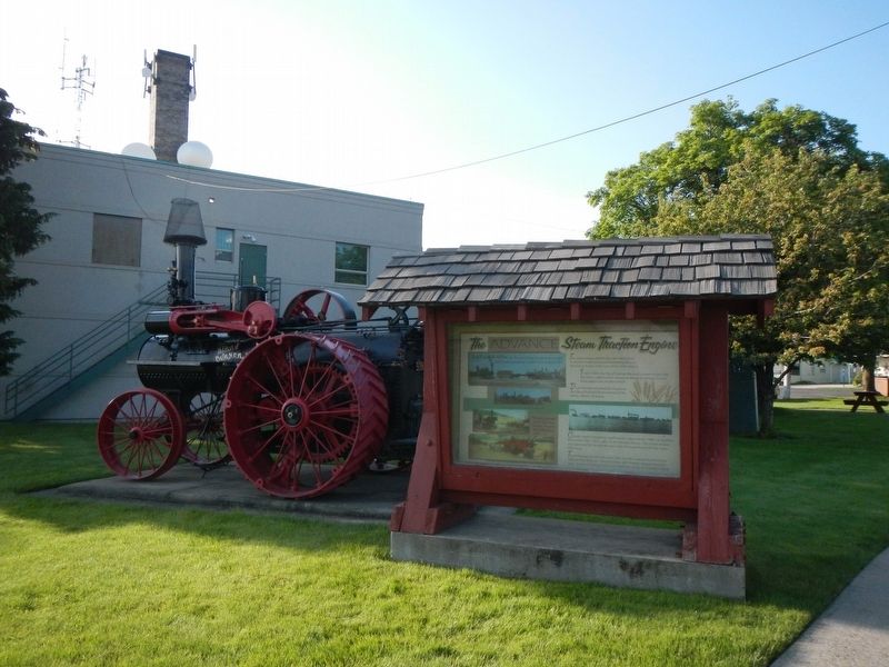
The steam engine before you saw many years of service to agriculture and lumbering here on the Camas Prairie at the turn of the 20th century.
In the 1920s the City of Grangeville used a steam engine like this with a roller in front instead of . . . — — Map (db m121269) HM
Before the continent was called America, before settlers came looking for land, the Nez Perce people lived and traveled throughout a vast area we now know as Idaho, Oregon, and Washington. They lived a semi-nomadic lifestyle, following the growing . . . — — Map (db m141249) HM
Look Up!
You're looking up at a full-size replica of the skeleton of a male Columbian mammoth. Mammoths are related to modern Asian elephants. Males stood up to 14 feet tall at the shoulders and may have weighed 10 tons. Females were . . . — — Map (db m141310) HM
Homesteaders flocked to the Camas Prairie in the early 1900s. Lured by the rolling, fertile land, John, Jake, and Gib Eimers, brought their hopes and dreams to Grangeville from Albion, Illinois. Soon after, sisters Elsie Eimers Bunting, Helen . . . — — Map (db m141254) HM
War has a way of making heroes and heroines of ordinary mortals. To some, Tolo, a Nez Perce Indian woman, was never ordinary. Her given name was Alab-lemot but because she loved to gamble, she was called Tolo which means "win" in the Chinook tongue. . . . — — Map (db m141246) HM
A scenic 1895 wagon road from Harpster to Elk City gave freighters and travelers better access across high ridges and rugged terrain to isolated mining camps
Sections of the steep, narrow road run close to a much older Nez Perce trail that . . . — — Map (db m123511) HM
During the mining boom Harpster boasted a hotel, a livery barn, a harness shop, four saloons, two general stores, a a drug store, and a blacksmith shop.
William Jackson built a toll bridge here across the South Fork of the Clearwater to meet . . . — — Map (db m121318) HM
Coming here May 10, 1839 to study with Lawyer, an important Nez Perce leader, he stayed to work on an Indian dictionary and to hold daily religious classes each spring and winter.
After spending six months in a “mere hovel,” he finished . . . — — Map (db m109774) HM
In May and June, they camped across the river from present-day Kamiah near the railroad bridge.
With their Nez Perce friends, they hunted, traded and played games.
They showed the Nez Perce “the power of magnetism, the spye glass, compass, . . . — — Map (db m109771) HM
Look north to the ridgeline behind you and see what Lewis and Clark and the Corps of Discovery faced on the morning of September 15, 1805. At 7 a.m. the Corps left their Colt Killed Camp near what is now the Powell Ranger Station.
Hoping for a . . . — — Map (db m123161) HM
President Thomas Jefferson, driven by a life-long passion for scientific exploration and study, instructed Meriwether Lewis to record details about the flora, fauna, geology and people of the land between the Missouri River and the Pacific Ocean. As . . . — — Map (db m123162) HM
In September of 1805 and again in June of 1806, Lewis and Clark traveled and mapped this area.
Their purpose was to explore the land, communicate with the Indians and establish the claim of the United States to the vast Pacific Northwest.
. . . — — Map (db m110304) HM
The townsite of Kooskia is situated within the Nez Perce Indian Reservation. Between 1889-1893, the Federal Government divided the 756,960-acre reservation into family-sized acreages called allotments. Although each Nez Perce adult and child . . . — — Map (db m121323) HM
(Four historical panels are located at the kiosk:)
The Lewis and Clark Expedition
The Lewis and Clark expedition known as the Corps of Discovery, passed through this area in September and October of 1805, on its way to find . . . — — Map (db m121344) HM
Route of September 15, 1805.
The Lewis and Clark Expedition passed through this area on their westward journey following a route used by the Indians to reach Salmon fishing grounds in the Lochsa River. The Indian trail they were following left . . . — — Map (db m123215) HM
Captain Lewis recorded on June 29, 1806: "...at noon we arrived at the quamas flatts (sic) on the Creek of the same name and halted to graize (sic) our horses and dine having traveled 12 miles. We passed our encampment of the (13th) September at 10 . . . — — Map (db m123219) HM
Looking Glass told army authorities: “Leave us alone. We are living here peacefully and want no trouble.”
But after a military attack, July 1, that destroyed his village, ruined his gardens and captured 750 Nez Perce horses, Looking . . . — — Map (db m109790) HM
You can find me on the ridgeline above you. I’ve seen many pass this way, some in joy and some in sadness, some in peace and some in war. For the Nimiipuu (Nez Perce) I was K’useyneisskit or ‘road to the buffalo.’ For the Selish (Salish) I was . . . — — Map (db m123165) HM
On July 23, 1877, approximately 750 members of the Nez Perce Nation, with over 2,000 horses, crossed Lolo Pass to escape the pursuing U.S. Army. Leaving their homeland behind, they followed this trail across the Bitterroot Mountains in an attempt to . . . — — Map (db m123218) HM
Living in Harmony with the Land You are standing near one of the well-worn trails and a crossroads of the Nimiipuu (Nez Perce) and Selish (Salish) peoples. Year round, the Mat’alaayma Bands of the Nimiipuu lived here, wintering along the . . . — — Map (db m123172) HM
Over one and one-half centuries have passed since Lewis and Clark crossed the Bitterroot Mountains.
This country was then a vast, challenging wilderness.
Immediately across the river from you, at this point, is the Selway – Bitterroot . . . — — Map (db m110320) HM
In July of 1877, nearly 800 Nimiipuu (Nez Perce) people traveled with heavy hearts across the Lolo Trail above you. They did not know if they would ever return to their homes. The women sang songs of sorrow and longing.
The journey began in the . . . — — Map (db m123163) HM
(This marker is composed of two panels and is presented here as if the panels were joined.)
The land today looks much the same as it did to Lewis and Clark. Today, as stewards of this beautiful land, we have an opportunity to leave a . . . — — Map (db m123213) HM
Above the parking lot is an open glade where natural mineral licks attract a variety of wildlife. These licks were named after George Colgate who was the cook for a hunting party in the early 1890s. Heavy snow trapped the group and prevented them . . . — — Map (db m123164) HM
126 ► Idaho, Idaho County, Lolo — 334 — Lolo Trail Crossing — When Lewis and Clark came up this ridge June 29, 1806 — they ran into "a shower of rain, with hail, thunder and lightning, that lasted about an hour" —
But they got out of deep Lolo Trail snow after they reached Rocky Point (directly across from here) and descended to Crooked Fork, below this turnout.
They reported that then they “ascended a very steep acclivity of a mountain about 2 . . . — — Map (db m109787) HM
On their westbound journey, Lewis and Clark crossed here, September 15, 1805 after camping 4 miles upstream at Powell.
Their Shoshoni guide had brought them down an old trail from Lolo Pass to a Lochsa fishery he knew about. To continue west, . . . — — Map (db m109782) HM
Many changes have occurred since the time Lewis and Clark used this route in the early 1800’s.
The mountains you see around you are now shared by the U.S. Forest Service and the Plum Creek Timber Company.
Each owns alternate sections of land . . . — — Map (db m109789) HM
The Lewis and Clark party crossed this pass Sept. 13, 1805, westbound for the Pacific after a long detour to the south.
From the headwaters of the Missouri they had crossed the mountains to the Salmon. Finding that river impassable, they traded . . . — — Map (db m27120) HM
Millions in gold – mined mostly in one big year came from the high mountain basin around Florence 14 airline miles east from here.
Early prospectors, fanning south from Pierce – Idaho’s first gold camp – came unexpectedly upon rich . . . — — Map (db m109650) HM
Visible directly across the river is a pit left by large scale hydraulic mining for gold deposited in ancient gravel beds.
Big nozzles, called “hydraulic giants,” shot powerful streams of water against a pre-historic river . . . — — Map (db m109642) HM
In 1862, a noted Western scout, Mose Milner, started Mount Idaho on his gold rush trail.
But when civic leaders resisted farm efforts to organize a grange there in 1874, Grangeville grew up as a better located town. Although Mount Idaho . . . — — Map (db m121317) HM
Over eleven thousand years ago, groups of Native Americans started the long history of land use in this area. The Nez Perce Tribe carried on the rich tradition of hunting, fishing, and gathering food, herbs and wood. Mountain men and early . . . — — Map (db m119353) HM
Pulled by two horses, one on either side of the rake, this device was used to gather hay for stacking. The buck rake would pick up the windrows of hay made by the dump, or side delivery rake. When loaded, the hay would be taken to the stack yard . . . — — Map (db m246283) HM
Early settler Charlie Clay, who operated a sheep ranch at Berg Creek, needed a better way to get his sheep across the river to the shearing plant located at the confluence of the Little Salmon and Salmon rivers. If the weather was bad or he felt . . . — — Map (db m119360) HM
Riggins’ first store was opened in 1897 by George Curtis, a storekeeper from nearby Lucile. Curtis converted Riggins’ first saloon into a much needed general store.
In 1903, Maggie Clay Rhoades and her sister, Carrie Belle Clay, hired carpenter . . . — — Map (db m119447) HM
First School (photo upper left)
The area’s first school opened its door in 1894 on a flat near the river in north Riggins. The small log cabin, with few windows and a fireplace, served as the classroom for fourteen students in grades . . . — — Map (db m119448) HM
Before the wagon road from White Bird to Meadows was completed in 1903, travelers endured a trecherous (sic) and roundabout overland journey. Seeing the need for a faster and more direct route, the enterprising J.J. Goff offered ferry service across . . . — — Map (db m119414) HM
Before recorded history, the area we know as Riggins was on the west coast of the North American Continent. Thousands of miles to the west was the Pacific Plate, covered by ocean with only a few high points rising above the water. This plate was . . . — — Map (db m119411) HM
If trees could talk, the big locust standing guard near the corner of Salmon Street might tell us all the details of the famous Gouge-Eye fight. It seems that Homer Levander and Big Markham got into a fight over comely Daisy Trumbull. According . . . — — Map (db m119358) HM
After a field has been plowed, it would then be necessary to break up the clods or cumps of sod and prepare the field for planting. Pastures also had to be maintained. The harrow devices which you see on display were used to accomplish these . . . — — Map (db m246295) HM
Displayed are two types of hay rakes, a side delivery rake and a dump rake. After the field
had been mowed, rakes such as these were used to rake the hay into windrows where it was
allowed to dry before being collected. The dump rake, the older of . . . — — Map (db m246278) HM
The horse drawn farm equipment which is displayed on Kirkwood Bar is representative of farm equipment used throughout Hells Canyon at the turn of the century.
The success or failure of the Hells Canyon rancher was largely dependent on his or . . . — — Map (db m246298) HM
On a ranch like Kirkwood there was never a shortage of things to be moved from one place to another. A wagon of some type was a necessity. This wagon or truck is typical of others seen at various sites in Hells Canyon. Both a hay and utility bed . . . — — Map (db m246275) HM
There were no formal churches in Riggins until the 1930s, but the early pioneers have always gathered together to worship. Jim Aitken, and other early homesteaders, often met in the schoolhouse to teach Sunday School from lesson plans taken from the . . . — — Map (db m119450) HM
Before you stands the north tower of the original Manning Crevice Bridge. The original bridge was located approximately 14 miles up on the Big Salmon Road. A new bridge was built and opened in 2018.
HISTORY: The Crevice Bridge was first . . . — — Map (db m119429) HM
This mowing machine is a gear drive, sickle bar mower. Two horses and a driver would normally be required to operate this piece of equipment. The mower would be used to cut the hay when ripe. The large lever on the right raises and lowers the sickle . . . — — Map (db m246294) HM
The Brundage House (photo top left)
301 South Main Street
Built in 1918, the Scott Brundage home was one of the nicest of its time in Riggins. In 1927, the home was leased to the U.S. Forest Service and was eventually purchased by . . . — — Map (db m119361) HM
The Riggins irrigation ditch was built in 1891 by early pioneers, Charlie Clay and brothers Isaac and Johnny Irwin, to supply water to their gold mining operation. By 1894, gold mining waned and the ditch was used for irrigation water. It wasn’t . . . — — Map (db m119354) HM
Before a field could be planted, it had to be plowed. Displayed here are examples of the types of plows used by hells canyon ranchers. From left to right they are as follows:
l. Steel walking plow or "foot burner." This plow was pulled by a . . . — — Map (db m246297) HM
Riggins Area Honor Roll
World War I
John Alkire • Henry Baker • Ed Boodry • George Boodry • Ed Clark • Vic Hinkley • Preston Jewett • Grenville Kimbrough • Mervin Mc Whinney • Bill Patterson WWII • Clinton Reeves • Earl Sewell • . . . — — Map (db m119430) WM
Riggins’ first hotel, Hotel Riggins, built in 1894 by pioneering businessman Dick Riggins, was located in the center of town across from Berger Street. The hotel also served as the post office and in 1901, Dick Riggins was appointed as the first . . . — — Map (db m119446) HM
Lighthouse of Highway 95
In 1946, Jim and Velma Summerville built a liquor bar, cafe, and supperclub. Summerville’s Cafe and Club was known as “The Lighthouse of Highway 95,” welcoming countless travelers to their 24-hour cafe. . . . — — Map (db m119409) HM
Occasionally a rancher was faced with the need to move relatively
large quantities of soil for the purpose of leveling ground, road construction, etc. The horse drawn scraper was used for this purpose. Displayed are two versions of the fresno. The . . . — — Map (db m246296) HM
From Allatlo'puh to Gouge-Eye to Riggins
The river terrace, now known as Riggins, has a long and varied history. Although it is known that the general area has been used by various groups of Native Americans for about 11,500 years, the oldest . . . — — Map (db m119489) HM
In 1897, the area surrounding Riggins was designated part of the Bitterroot National Forest Reserve. The Riggins area was included in the Weiser Reserve in 1906, then added to the Nez Perce National Forest in 1908.
First Forest Service Ranger . . . — — Map (db m119362) HM
In the 1890s, Captain “Cap” Guleke began making regular float trips down the Salmon River from the town of Salmon to Riggins. He would build a large wooden sweep boat, called a scow, and deliver supplies to river ranches. At the . . . — — Map (db m119413) HM
John Riggins was Riggins' first mailman, carrying the mail from Grangeville to New Meadows by horseback and sometimes by foot. By 1893, he operated a stage line from Grangeville to Fiddle Creek, north of Riggins and the end of the wagon road. He . . . — — Map (db m109852) HM
After the Clearwater Battle on the heights above here, July 11-12, 1877, the Indians crossed the Lolo Trail to Montana.
Advancing northward along the high ground with 600 troops and artillery, General Howard found the Indians camped on . . . — — Map (db m121319) HM
The Lewis and Clark Expedition passed this site in late September, 1805. On their return journey in June 1806, they camped on the open hillside. The party has been traveling on top of several feet of snow in most areas so the grassy feed found here . . . — — Map (db m140792) HM
"Our American horses were not used to the fodder of the native cayuse. We carried no forage. If we should chance upon one of the little mountain valleys where there should be grass, we found it either trampled down by Joseph's ponies or destroyed . . . — — Map (db m140784) HM
"...This trail so old it used from time of creation by Nez Perce people to go to Montana to hunt Buffalo and some time to war other tribes of Indians, when Red Bear come to Indians Post Office on this trail, he tell Lewis - Clark and all, stop . . . — — Map (db m140783) HM
In the earliest times, native people crossed these mountains on foot with only what they could carry on their back. After the early 1700s, the horse made the trek easier and allowed travelers to carry more goods over the mountain trails.
For . . . — — Map (db m140787) HM
Aided by six Nimiipuu (sic) (Nez Perce) guides, the Lewis and Clark Expedition moved quickly across the Lolo Trail in June, 1806. Even though the snow was nearly seven feet deep on most to the trail, the party was able to find their way.
Smoking . . . — — Map (db m140789) HM
Built by Carl Hanna ca. 1912, this cabin was originally located at the site of the Carter Mansion, approximately three quarters of a mile up Kirkwood Creek. A few years after constructing the cabin, Hanna left for Europe and World War I from which . . . — — Map (db m141220) HM
Once the hay was collected from the fields it has to be stored, either in a hay stack or barn. This was accomplished using a device known as a Jackson Fork. Used in combination with a complex set of lines and pulleys, the hay was lifted into the . . . — — Map (db m141224) HM
On the more distant of the ridges Lieutenant Theller halted and deployed his advance guard, at the same time sending word that the Indians were in sight. I immediately formed my company 'left front into line’ at a trot, gave the order to drop . . . — — Map (db m119505) HM
The Carter mansion, located approximately three quarters of a mile up Kirkwood Creek was built by Clarence "Dick" Carter ca. 1921. In terms of Hells Canyon architecture, this unique five bedroom log structure is a mansion in its own right. Replete . . . — — Map (db m141213) HM
A vast mountain wilderness, cut by the mile deep Salmon River Canyon stretches across Idaho south and east of here.
Travel through the Salmon River Mountains always was hard in the early days.
An 1872 railroad survey showed the Salmon . . . — — Map (db m109667) HM
Then this part of the earth’s surface gradually rose.
As the mountains were rising, the river cut down into the older rock below.
Many other northwestern rivers cut similar gorges.
The Snake flows through Hell’s Canyon – deepest of them . . . — — Map (db m109662) HM
Constructed in 1952, the Sterling Cabin was built by Dick and Bonnie Sterling for Bud Wilson, then owner of the Kirkwood Ranch. Dick was the packer and Bonnie was the cook for the Kirkwood Operation. Constructed of lodgepole pine logs, cut in the . . . — — Map (db m141221) HM
In 1932, Len Jordan brought his young family to Kirkwood. He and his partner, Dick Maxwell, purchased the ranch from Leonard and Kenneth Johnson. They hoped to live cheaply off the land and ride out of the Great Depression of the 1930's in Hells . . . — — Map (db m141211) HM
Five warriors, led by wet’itwe’tit hawalis . . . had been sent out . . . as a peace party to meet the soldiers. Of course they carried a white flag.
Peace might be made without fighting. -- himi'n maqsmaqs (Yellow . . . — — Map (db m119506) HM
(Three panels are located at this kiosk overlooking the White Bird Battlefield.)
We were marched into a deep canyon and to a country strange to us, and familiar to the enemy. If there was any plan of attack, I never heard of it. -- Sgt. . . . — — Map (db m121137) HM
For 60 years after construction was completed in 1915, White Bird Grade (Across the Valley) served Idaho’s only north-south highway.
Many tortuous curves and switchbacks -which, if placed together, made 37 complete circles - let the old road . . . — — Map (db m119507) HM
A gold rush to Montana brought steamboat service to lake Pen d'Oreille in 1866, with its dock at Pen d'Oreille City 5 miles east of here on Buttonhook Bay.
Traffic to British Columbia's Wild Horse mines also used this route. The trip . . . — — Map (db m122152) HM
Large kilns that produced line from 1904 to 1932 still can be seen by visiting Bayview, two miles from here.
Production of lime for nearby mines and Spokane buildings commenced in this area as soon as rail transportation and markets . . . — — Map (db m122170) HM
In 1942, a large United States Naval training station, with facilities for 40,000 sailors, opened here. Then, from 1946 to 1949, it became Farragut College.
When postwar college enrollments slacked off, Farragut State Park was developed here, . . . — — Map (db m122155) HM
Once the grounds of a naval hospital, this area of park is now home to four disc golf courses.
In 1942, the US Government acquired this land to build a navy training station. Over the next four years 293,381 men went through their boot training . . . — — Map (db m122172) HM
This type of canoe was not used by the Coeur d'Alene until the arrival (of the) pioneer settlers. Combined with iron tooling and burning, it took two men up to eight weeks to build. The Indians preferred their traditional bark-skinned canoe . . . — — Map (db m122768) HM
The horse-powered grist mill is shown with a half-timbered frame. Brother "blacksmith" (either brother Charles Huet or Classans), and brother Magri collaborated on fashioning the grist mill in 1848. This would be before construction began on the Old . . . — — Map (db m122766) HM
Records indicate that a least forty Coeur d'Alene Indians lived in permanent residence at the Mission site. The village was make up of a mixture of log cabins, Native American mat lodges and an occasional tipi.
E.S. Glover in his diary of 1875 . . . — — Map (db m122769) HM
The sketch drawn in 1860, shows a long multiple-unit structure parallel to the church. It housed the Mission brothers and travelers, a kitchen and repair shop.
Some of the prominent travelers who visited the Mission and possible stayed in this . . . — — Map (db m122764) HM
The main cemetery with log houses (grave houses) was located in this area. The limits of this have not been fully established (as of 1976); but according to the Mission records,
well over 300 people have been buried here. Many of the . . . — — Map (db m122770) HM
The Coeur d'Alene River is moderately visible from this vista point. The river aided in popularizing the Sacred Heart Mission by creating a steamboat access for outlying communities.
For one dollar, passengers could enjoy the 27 mile river . . . — — Map (db m122763) HM
Built by the Coeur d’Alene Tribe in cooperation with members of the Society of Jesus – restored with dedication as a 1976 bicentennial project by Henry Lawrence Day and his friend and helper Al Almquist in whose honor this memorial is . . . — — Map (db m110800) HM
“At sundown the church bell toiled, and it was soon filled with humble worshippers.
The chapel is quite an impressing building, the walls covered with pictures of saints and crucifixion.
The Indians are very devout and tell . . . — — Map (db m110799) HM
Opened for services in 1853, this is the oldest building in Idaho.
Black-robed Jesuits founded the mission on the St. Joe River in 1842, but moved here in 1846 and raised this imposing building in a complete wilderness. Dwellings and . . . — — Map (db m110802) HM
The Coeur d'Alene River once flowed through here. Dams raised the level of Lake Coeur d'Alene causing the river to develop new channels. Annual flooding now furnishes water and silt to this former river bed. — — Map (db m122767) HM
The Parsonage house was the permanent house for the superior of the Mission. It is shown with a stone foundation. The west extension is depicted with a board floors, possibly a porch-like structure. The building was constructed with hewn logs using . . . — — Map (db m122762) HM
In 1853, Issac I. Stevens, Governor of the Washington Territory, described the Mission as being composed of buildings enclosing a square, some being quite old, but the barn was large and new. One-half of the barn was reserved for their crops, while . . . — — Map (db m122765) HM
This smoke chaser cabin was moved from its original location along the Coeur d'Alene River (Coeur d'Alene National Forest) as a part of the nations 1976 bicentenial celebration. It was built in 1924 by Bill Guernsey and Pete Jackson — — Map (db m306522) HM
Look to the north: blocking the northward passage of the rivers which form this lake, a great dam of glacial ice once towered above the horizon as far as the eye can see. When the glacier melted, about 600,000 years ago, it left a moraine - a . . . — — Map (db m122872) HM
Constructed in 1880 by the U.S. Army, the Fort Sherman Chapel is recognized as Coeur d'Alene, Idaho's oldest church, school, library, and meeting hall. The Fort Sherman site was abandoned in 1900 and the property was sold at public auction in 1905. . . . — — Map (db m306518) HM
In the summer of 1877, while on an inspection tour, General William T. Sherman selected this site for a fort. Established and garrisoned in the spring of 1878, Camp Coeur d'Alene was built from the wilderness frontier and grew to include 52 . . . — — Map (db m306519) HM
Built by the army in 1880 to carry hay and supplies for Fort Coeur d'Alene, the "Amelia Wheaton" was the first of a long list of steamers on this lake. Commercial steamboating began in 1884 with the mining rush. In later years, fleets of . . . — — Map (db m122877) HM
Walk the Mullan Road one of the Northwest's most significant routes. Take the side road to your left.
From 1858-62, Lt. John Mullan's crew built the Northwest's first engineered highway, connecting Fort Benton with Fort Walla Walla, 625 . . . — — Map (db m122859) HM
Between 1859 and 1862 the U.S. Army built a military wagon road between Fort Benton Montana, and Fort Walla Walla, Washington. This National Historic Civil Engineering Landmark was the first major engineered highway in the Pacific Northwest. — — Map (db m122863) HM
341 entries matched your criteria. Entries 101 through 200 are listed above. ⊲ Previous 100 — Next 100 ⊳