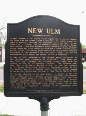
In 1851, leaders of the Dakota Nation signed the Treaty of Traverse des Sioux with the United States Government. This treaty opened new lands in Minnesota Territory for settlement. Two years later, German immigrants in Chicago, led by Frederick . . . — — Map (db m65452) HM
Schonlau Park, named in honor of Theodore H. and Clara K. Schonlau, is the setting for the City of New Ulm’s unique Glockenspiel. Local contributors were joined by donors from three foreign countries, 31 States, and 51 other Minnesota cities, in . . . — — Map (db m65492) HM
Frederick Beinhorn and Wilhelm Pfaender, pioneer founders of the prairie colony of New Ulm, were cut of the same cloth. Both came to America from Germany after the 1848 Revolution in Central Europe failed to unite German peoples under a new frame . . . — — Map (db m65694) HM
In memory of our honored brave who fell in defence of The Union.
In memory of those who fell in defence of New Ulm 1862.
In memory of those massacred by the Indians in Brown Co. 1862.
Erected by the citizens of Brown Co. . . . — — Map (db m68705) WM
While crossing this ravine a
recruiting party of the Civil War
was ambushed by the Sioux
Indians on August 18th, 1862, at
the noon hour.
The following were killed or
mortally wounded:
John Schneider • Ernest Dietrich . . . — — Map (db m73704) HM WM
On this site in 1859 Frederick Roebbecke built a seventy foot high wooden windmill for grinding corn and grain. Situated on a prominent ridge, it commanded an excellent view of the scattered settlement. Barricaded with sacks of flour and grain, the . . . — — Map (db m65400) HM
In 1874, shortly after George Kuhlman arrived in New Ulm, he constructed a home on this site. The same year, he was appointed as Brown County’s Attorney to fill a one-year opening left by his predecessors death. In addition to his legal vocation, . . . — — Map (db m153851) HM
To pay homage to the sturdy pioneers who founded the territory of Minnesota a century ago. And to express veneration for the pioneers of Brown County and members of their families who lost their lives during the Sioux War of 1862 — 1863. . . . — — Map (db m73642) HM WM
This neighborhood dates back to the early days of New Ulm. Oral history suggests the borders shown above. The origin of the name “The Wallachei” is obscure. The most likely translation is “low land horse pasture.” Or, legend . . . — — Map (db m65396) HM
The Turner concept of developing a sound mind and body through discussion of common problems and physical exercise was conceived by Frederick Jahn of Berlin in 1811. It was an effort to strengthen German resolve against the French conqueror, . . . — — Map (db m65426) HM
Von hier 717 fuss in der Richtung des Pfeils wurde am 11ten November 1856 der New Ulmer Turnverein gegruendet.
(From here, 717 feet in the direction of the arrow on the 11th of November 1856 the New Ulm Turnverein . . . — — Map (db m66239) HM
The first news of the Sioux Uprising was brought to New Ulm at noon on August 18, 1862, by survivors of a Civil War recruiting party that had been ambushed in Milford Township. Barricades were hastily erected in a three-block area on Minnesota . . . — — Map (db m65402) HM
The federal government erected the post office building in 1910, designed by James Knox Taylor, the supervising architect of the United States Treasury. Although the city's postal service began in 1856, it had been located in rented space . . . — — Map (db m74074) HM
The first river steamboat, WEST NEWTON, passed by here in 1853 going upriver with troops to lay out the site of Fort Ridgely. Two days later TIGER and CLARION followed with men and supplies.
For the . . . — — Map (db m66383) HM
Henry A. Subilia, a native of Jean, Italy, constructed the Waraju distillery in 1861. The construction cost total of $8,000, plus $2,000 for furnishings. The building required approximately 200,000 bricks and measured 72 feet x 46 feet. It obtained . . . — — Map (db m153916) HM
In 1857, Rev. August Huelster held the first Evangelical church service at the home of Charles Lauer in Cottonwood Township. In 1865, two acres of land were purchased in Cottonwood Township by John Mohr, Philip Pfisterer & Carl Schreyer, . . . — — Map (db m78463) HM
Searles, a small community in Section 21 of Cottonwood Township, was platted on October 10, 1899, by Harry and Anna Jenkins. It was a railroad station point named by officials of the Minneapolis and St. Louis Railroad.
The original plat . . . — — Map (db m67914) HM
Sleepy Eyes, or Drooping Eyelids, was born about 1780 in a Sisseton Sioux Indian village at Swan Lake in Nicollet County. The Bureau of Indian Affairs commissioned him a chief in 1824. His fame was achieved not as a warrior or hunter but as a . . . — — Map (db m67658) HM
In the summer of 1851 the Dakota Indians, a group of Native Americans who lived in Southern Minnesota, sold their land, 35 million acres, to the United States for $3,000,000. The Dakota agreed to move to a reservation which included land ten miles . . . — — Map (db m67983) HM
The village of Golden Gate occupied this area for some years. The town took its name from the U.S. Post Office established in 1868 with Ebenezer Fuller in charge.
Construction of a water-powered grist mill on Spring Creek in 1869 by . . . — — Map (db m70993) HM
The mill, built in 1867 by John Heimerdinger, was down 1/4 mile from Golden Gate on the Ruhe-Heim Creek. It was powered by a pond kept full by many wells, dug by hand. Wheat was ground by stones into flour and feed. — — Map (db m71062) HM
In 1866 the budding village of Iberia had a log school house, four frame buildings and a cemetery. The settlement is the center of Stark Township, organized in 1866.
Iberia crossroads was named for a community in Ohio because many of the first . . . — — Map (db m73752) HM
In honor of the
Brave Service Men & Women
who have defended and
continue to defend the
United States of America.
Sons of John & Mary Broich
Chris USNR, Art USNR, Walter USAF, Joseph . . . — — Map (db m67856) WM
In the 1850s there was a land boom in southern Minnesota. Jonathan Brown, 37 years old, filed on land along the Cottonwood River in what is now Burnstown Township. (S 1/2 of SW 1/4, Sec. 15; N 1/2 of NW 1/4 of Sec. 22)
Jonathan picked a good . . . — — Map (db m67820) HM
John and Daniel Burns were pioneer settlers in this area of brown County. Burnstown Township was named in their honor.
Railroad construction advanced westward and the name of the station stop here in 1873 was "Burns." A small settlement . . . — — Map (db m67542) HM
Proudly, we salute our veterans and
pledge eternal gratitude for their sacrifices and
gallant preservation of freedom for all.
seals of the United States Army • Air Force • Navy • Marine Corps • Coast Guard
Dedicated July 4, 1994 . . . — — Map (db m71172) WM
"What is old is not good.
What is new is good.
Think only on the new.
In that way, by degrees
you will be able to attain
something. That is the way.
Among other peoples beyond
ours, men consider that alone....
The Dakotas are getting . . . — — Map (db m176416) HM
Tokanne (Mary Little Crow Renville) (1789-1840) was born a Kaposia
Bdewakantuŋwan toward the end of the 18th century when tribes
throughout the Midwest were actively developing kinship alliances via
marriage into the Canadian fur trade . . . — — Map (db m176989) HM WM
Fort Renville, the headquarters of the fur trade in this area during the 1820s and 1830s, was located at the bottom of this hill.
Joseph Renville, son of a French trader and a Dakota woman, began trading for furs at Lac qui Parle in . . . — — Map (db m176307) HM
The first cabin built at the Lac qui Parle mission was
completed near this site by Alexander Huggins and
Thomas S. Williamson in October of 1835 for the Huggins
family. Originally a one-room 16-foot-square structure
chinked with mud, it was . . . — — Map (db m176336) HM
“Considering how different all their thoughts are from ours and how unlike
to everything which they have ever seen or heard would be the whole way
of salvation, it is not to be expected that we could make them understand
or believe much of what . . . — — Map (db m176400) HM
Lac qui Parle Mission was
established in 1835. Here Christian
missionaries founded one of the
earliest churches and schools in
Minnesota. You can visit a replica
of the chapel built with the help
of Dakota people in 1841, and
you can see the . . . — — Map (db m176311) HM
Thomas S. Williamson (1800-1879) and Margaret Poage Williamson
(1804-1872), the founding couple of the ABCFM mission to the Dakotas. With their
young daughter, Elizabeth, they arrived at Lac qui Parle on July 9,1835 from Ripley,
Ohio, . . . — — Map (db m176978) HM
Stephen R. and Mary Riggs built a new home for their
family here in 1848. The one-story frame house contained
a living room, small kitchen and two bedrooms.
Mission farmers Jonas and Fanny Pettijohn built their
cabin nearby. Both cabins were . . . — — Map (db m176401) HM
And Jesus came and said to them,
“All authority in heaven and on
earth has been given to me.
Go therefore and make disciples
of all nations, baptizing them in
the name of the Father and of
the Son and of the Holy Spirit,
teaching them to . . . — — Map (db m176633) HM
"These are territories that
we hold from no one but
the Master of Life who
gave them to us."
- Dakota chief to
French Diplomat
Joseph Marin, 1754
Dakota people were created in Mni Sota Makoçe. Minnesota has always been their . . . — — Map (db m176408) HM
Thomas S. and Margaret Williamson's 1½-story log
cabin was completed near this location in December, 1836.
One of the first two rooms also served as a church and
school until 1841. Missionaries Stephen and Mary Riggs
lived in one of the upstairs . . . — — Map (db m176310) HM
The Minnesota River Valley is a witness to time. Rocks formed 3.8 billion years ago — some of the oldest in the world — lie exposed on the valley floor. These grey, pink and red granite rocks are memorials to a fiery young earth when . . . — — Map (db m69039) HM
The river, the wooded bottomlands, and the prairie provided a wealth of game and furs for the Dakota.
The Dakota fished in the river and hunted small game in the forests along its banks. They trapped beaver and muskrat for their furs. And . . . — — Map (db m259745) HM
“Grand Old Lady of the Prairie"
Florence Cook Roefer (1913-2000) was an early leader in preserving these rock carvings and the surrounding prairie. As the first site manager of Jeffers Petroglyphs, Florence nurtured 33 acres of . . . — — Map (db m140823) HM
This outcropping is an “erosional high”-rock
smoothed off by glaciers.
Continental glaciers advanced and retreated across this region many times in the last million years, before leaving for good about 12,000 years ago. . . . — — Map (db m140824) HM
About 14,000 years ago this landscape was covered with ice.
When the ice melted, an open parkland dotted with black spruce developed. After a period of warming and drying, forests of oak and elm replaced the spruce. People began living . . . — — Map (db m140820) HM
What are those fence posts doing in the middle of the prairie?
They used to mark the edge of a farm field. In 1974 the Minnesota Historical Society planted a few grass varieties on 50 acres of cropland, initiating one of the first . . . — — Map (db m140804) HM
Prairie fires set by lightning or by people were common in this region.
Fortunately, most prairie plants are long-lived perennials with deep, extensive root systems. Their ability to produce vigorous new shoots below the soil's . . . — — Map (db m140822) HM
People hunting game most likely traveled this ridge, which provided a dry route above the lake-dotted prairie for thousands of years.
The earliest inhabitants of this region hunted woolly mammoths and musk-ox. Beginning with the . . . — — Map (db m140821) HM
This property has been placed on the National Register of Historic Places by the United States Department of the Interior Cottonwood County Courthouse 1904 — — Map (db m157788) HM
All Gave Some
Some Gave All
All veterans are honored and remembered by the
Windom Veterans of Foreign Wars Post #3844
Granite monument:
La Grange Post No. 79.
61 G.A.R. 65
Women's Relief Corps
61 No. 36. . . . — — Map (db m234289) WM
Windom High School Graduate • 1935 University of Minnesota • 1935-1939 Green Bay Packers • 1939-1941 Voted: Minnesota’s MVP • 1938 All American Athlete • 1939 Green Bay Hall of Fame • 1942 — — Map (db m157782) HM
The nation celebrated completion of Interstate 90 after contractors paved the last four-miles of freeway near Blue Earth in 1978. Reminiscent of the "Golden Spike" that symbolized completion of the nation's first transcontinental railroad in . . . — — Map (db m178485) HM
A Golden Dedication for I-90
The nation celebrated completion of Interstate 90 after contractors paved the last four-miles of freeway near Blue Earth in 1978. Reminiscent of the "Golden Spike" that symbolized completion of the nation's first . . . — — Map (db m96915) HM
The Episcopal Church of the Good Shepherd was built in 1871-72 in the Gothic Revival Style. It has a steeply pitched roof and batten-and-board siding. Four buttresses brace each side and the bell tower is buttressed on the south. The Guild Hall on . . . — — Map (db m274400) HM
The Etta C. Ross Memorial Library was a gift to the city by W.E.C. Ross in memory of his wife Etta Chadbourn Ross. Mrs. Ross, who died 21 March 1903 at age 48, had been one of the community's leading advocates of reading and literature.
Blue . . . — — Map (db m294645) HM
With the Louisiana Purchase in 1803, the United States acquired a vast area west of the Mississippi River. Eager for information about its new territory, the government dispatched a series of explorers to learn more about the land and the native . . . — — Map (db m178486) HM
With the Louisiana Purchase in 1803, the United States acquired a vast area west of the Mississippi River. Eager for information about its new territory, the government dispatched a series of explorers to learn more about the land and the native . . . — — Map (db m294302) HM
1977 Faribault County Courthouse placed on National Register of Historic Places
Tower restoration made possible by 1976 Bicentennial Grant — — Map (db m294307) HM
Dedicated to the memory of the men and women from Faribault County who have served their country in war and peace. Past, present and future. — — Map (db m294305) WM
Why the big guy?
The Green Giant Statue is a symbol of the long standing association of the City of Blue Earth with the Green Giant company. Peas and corn are still grown and canned here today.
How long has he been standing there? . . . — — Map (db m270049) HM
Since its territorial days in the mid-19th century, Minnesota's identity has been rooted in agriculture. With acres of prairies and woodlands to turn into farms, the state proved attractive to waves of settlers from eastern states and other nations. . . . — — Map (db m294301) HM
To honor and commemorate the first settler of Faribault County. Moses Sailor settled here May 25, 1855 lived here until his death 1896. — — Map (db m294304) HM
Ice Age Beginnings
The prairie landscape was formed by glaciers and their melting waters. The soil began as rock pulverized by these glaciers. The sand, silt and clay particles form a soil matrix. Nearly two thirds of the soil matrix is . . . — — Map (db m196202) HM
The Wakefield House was built in 1868 of locally made brick for James B. Wakefield. It is the oldest structure in Blue Earth. The house is an L-shaped, two story Italianate residence with arched windows. Devoid of brackets and other applied . . . — — Map (db m294648) HM
The Big Sponge
Minnesota's original tallgrass prairie spread over a rolling landscape marked with countless small ponds and wetlands called prairie potholes. When snow melted or rain fell, this landscape promptly soaked up the water – like a . . . — — Map (db m196194) HM
Drainage of surface water is vital to all aspects of development, from town sites to agricultural crop land. Its importance, impact, and consequences cannot be over stated. With the western expansion of the United States, swamp lands. as they . . . — — Map (db m166441) HM
Nothing But Prairie
Look across the landscape. Imagine standing here in 1850.
There were no farms, no roads – only tallgrass prairie,
shimmering in the wind as far as the eye could see.
The lifecycle of these southern Minnesota . . . — — Map (db m161865) HM
Erected by the State of Minnesota
in the year 1909, to the memory of the pioneer setters of Jackson County, whose names are inscribed below, massacred by the Sioux Indians on March 26th, 1857, and August 24th, 1862.
1857 Massacre
William . . . — — Map (db m205190) HM
Olson Slaabakken Cabin
Emmet Olson donated this cabin to the city of Jackson in 1926. The cabin is said to have been the first cabin occupied by the family of Engebret Olson when they arrived in Jackson County in 1860. He said that he traded a . . . — — Map (db m205193) HM
This cabin was donated by
Emmet Olson
in 1927 to this park.
Built prior to 1860, the cabin was the home of these Norwegian settlers who underwent the Indian massacre of Aug. 24, 1862, in Belmont Twp. north of Jackson. Sioux raiders . . . — — Map (db m205191) HM
500 feet west, the Wood brothers, believed to be the first settlers of Jackson County, established a trading post in July, 1856. The present city of Jackson is located on their claims.
Dedicated June 29, 1956 — — Map (db m274407) HM
A Home Without Trees
Although there are no trees to nest in, tallgrass prairie is home to more than 240 bird species. The birds have adapted their behavior to survive in the treeless prairie.
The Western Meadowlark creates a home among . . . — — Map (db m305371) HM
When the St. Paul, Sioux City & Omaha Railroad came to southwest Minnesota in the early1870s, it established stations along the way. A siding was established at a place called Timber Lake (Sec. 7-Delafield Township) which eventually became known as . . . — — Map (db m233117) HM
At the start of the U.S.-Dakota War of 1862 settlers around Columbia (now Spencer) hastily formed an oxcart train and started for the stockade at Forest City. On the way to Diamond Lake, the refugees ran into other settlers fleeing from the Eagle . . . — — Map (db m77228) HM
When Daniel Delaney and a man named McLeod camped on the shores of the lake in 1855, they became the first white men of record to visit the area. John Masters, a land developer who came in 1856, gave the body of water its name.
Diamond has . . . — — Map (db m76925) HM
The Red River Trail was the nineteenth-century answer to communication over the frontier between the early settlements on the Mississippi and Minnesota Rivers and Lord Selkirk's settlements (Winnipeg) in Canada. Trails, such as this, were not . . . — — Map (db m77016) HM
After fighting a running battle with the Dakota on August 20, 1862 at Diamond Lake, two groups of refugees from Spicer and Eagle Lake camped here at Wheeler's Lake. The Dakota camped across the lake from them. There were no disturbances during . . . — — Map (db m77273) HM
On June 24, 1882, one of the most disastrous railroad wrecks in Kandiyohi County's history took place here. The train left Willmar to travel to Grove City gravel yards with 45-50 men on board. Two and a half miles west of Atwater the train's tender . . . — — Map (db m231744) HM
In 1872, February 2 began as a beautiful winter day with several inches of freshly fallen snow. The animals gave the first indication of the turn in the weather with the birds flying low and the cattle lowing restlessly. By that afternoon, the . . . — — Map (db m231746) HM
Captain John S. Cady ambushed by Indians from this spot June 11, 1863.
Following the suppression of the Dakota (or Sioux) Uprising of 1862 the Eighth Minnesota Volunteer Regiment patrolled the frontier from Hutchinson to the Red River. Captain . . . — — Map (db m231708) HM
Birthplace of Henrik Shipstead (1881-1966), the first native of Kandiyohi County to be elected to U.S. Senate. Henrik Shipstead was born on January 8, 1881 here in Burbank Township, Kandiyohi County, Minnesota, one of Norwegian immigrants Saave and . . . — — Map (db m231767) HM
The morning of January 7, 1873, was mild and pleasant enough to encourage many farmers to make trips to town or to work in their woodlots. Shortly after 2 p.m. a howling blizzard of snow, driven by a 70-mph northwest wind broke the calm. The . . . — — Map (db m79353) HM
Immediately following the U.S.-Dakota Conflict of 1862, the United States Army established a chain of small military posts to stabilize the nearly abandoned frontier by keeping everyone—Dakota and settlers—out of the area. Temporarily mounted for . . . — — Map (db m231704) HM
What is believed to be one of the last pitched battles between the Ojibwe and Dakota ended near this marker about 1860. Some Dakota hunters found a party of Ojibwe encroaching on Dakota grounds. They attacked, killing several Ojibwe and driving the . . . — — Map (db m78413) HM
Kandiyohi Town Site Corporation was organized in 1856, with John Swainson as president. By October of that year, the town site had been surveyed. David Charlton's plat indicates a large central area reserved for the State Capitol with a much . . . — — Map (db m78239) HM
Mrs. Carrie (Pehrson) Johnson, the first white person buried in what is now Kandiyohi County, came here with her husband, John, and six month old son in the fall of 1857, from Sweden. She died in April 1858, and was buried near her new house. After . . . — — Map (db m78311) HM
John Other Day, a Dakota who disagreed with the decision to go to war with the Whites, led a party of sixty-two white men, women and children out of danger when the Dakota attacked the Upper Sioux Agency near Granite Falls. The party left the Agency . . . — — Map (db m76656) HM
Wakanda is a spiritual place or "where the spirit dwells" in Dakota. The Dakota people named this area before the settlers came to Kandiyohi County. Prior to 1900 there was evidence of this being a place of burial grounds. Over time, erosion and . . . — — Map (db m231706) HM
A founding member of the Kandiyohi County PF (Pheasants Forever), Dalton worked tirelessly to keep the fledgling chapter going. He was committed to a cause he strongly believed in.....establishing quality habitat to help all . . . — — Map (db m77082) HM
On August 16, 1885 thirty people met at the home of Erik and Anette Larsen located in Section 26 of Fahlun Township and under the direction of Rev. A.N. Kleven, a new Lutheran congregation was organized by the name of "Tromso Lutheran Church," . . . — — Map (db m78263) HM
The United States Army responded to the U.S. - Dakota War of 1862 by carrying out federal government security policies of removing remaining noncombatant Dakota people and pursuing combatants while protecting settled areas. In August 1863, Jesse V. . . . — — Map (db m78292) HM
The Farm Holiday Association, which at one time was reported to be the largest organization of farmers in the United States, began in Kandiyohi County in 1932. One particular incident led to the formation of this organization. A Kandiyohi County . . . — — Map (db m231711) HM
1865 Louis Larson filed homestead rights and named the site New London.
1867 Merchants W.W. Pinney and Samuel Adams each built and opened stores. Postal service began.
1868 New London became county seat of Monongalia County.
. . . — — Map (db m79619) HM
1938 A thorough study of a hundred acre location was carried out by the U.S. Commission of Surveys. Dam and mill site were purchased for $14,000. Land for fish ponds extended a mile downstream. Citizens contributed $1,300, and some easements . . . — — Map (db m79642) HM
During the Dakota Conflict of 1862, there were no casualties among the Norway Lake community settlers, although several from the nearby West Lake community were killed. On August 20, survivors from West Lake and other settlers from the Norway . . . — — Map (db m75746) HM
In 1879 this village of Jericho was established in the historic Norway Lake settlement, 20 years after the first Norwegian immigrants arrived. A general store with a post office, a blacksmith shop, a creamery, and other businesses prospered in . . . — — Map (db m78215) HM
This Monument is Erected by the
State of Minnesota,
in Memory of
Anders Petter Lundborg,
born Mar. 23, 1837.
Gustof Lundborg, born Apr. 30, 1839.
Lars Lundborg, born Dec. 22, . . . — — Map (db m78140) HM WM
1858 A natural waterfall was discovered by pioneer Larson while on a hunting and trapping expedition three miles upriver from Nest Lake.
1859 Larson established a camp near the falls but had to abandon it when his tent and most of his . . . — — Map (db m79590) HM
1946 Forty-two veterans met and signed the petition for a charter. The post was given its name in memory of Robert Ihlang who was killed in Italy during World War II. The charter was granted, and the officers were: commander, Victor Suneson; . . . — — Map (db m79634) HM
606 entries matched your criteria. Entries 101 through 200 are listed above. ⊲ Previous 100 — Next 100 ⊳