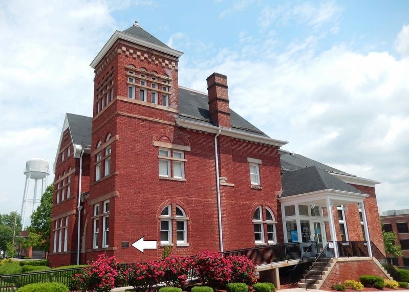
Constructed using the Richardson-Romanesque Style of architecture, this building served as a Post Office and United States Courthouse. — — Map (db m1977) HM
This High Victorian Gothic structure which served as the Martinsburg High School, now houses the Berkeley County Board of Education office. — — Map (db m132394) HM
This structure was originally constructed as a dwelling and was later used as a house of worship from 1812-1842 by the Methodist Episcopal Church. — — Map (db m134000) HM
The woolen mills were located in the buildings on the south side of the street and the cassimere mills on the north. Outstanding examples of industrial architecture. — — Map (db m134032) HM
Roundhouses and Shops. The B&O Railroad reached Martinsburg in 1842,
and by 1849, a roundhouse and shops were
built. These first buildings were burned by
Confederate troops in 1862. The present west
roundhouse and the two shops were built . . . — — Map (db m1197) HM
Here on July 4, 1861, Belle Boyd, at the age of 17, shot and killed a Union soldier. She was imprisoned on several occasions as a result of her later spying activities. — — Map (db m193346) HM
This Romanesque Revival Church was begin in 1845 and dedicated in 1860. George Whitson, local architect, designed the Greek portico with the Gothic spire in 1888.
[Bottom plaque]
Most Reverend Bernard Schmitt, D.D.
Designated . . . — — Map (db m132395) HM
The present building was completed in 1917 under the leadership of Fred R. Ramer. He was the first principal in Berkeley County to have a school named after him. Ramer school served the black community until 1964. — — Map (db m1211) HM
In the early hours of February 19, 1886, a mob of White men removed Joe Burns from the cellar of the local jailer. Mr. Burns, a Black man, was accused but never tried for assaulting a White woman. The vigilantes taunted, mutilated, and hanged Mr. . . . — — Map (db m269314) HM
400 Yards West of This Spot Is The Red House
The Home of Edward Beeson
Where the County of Berkeley was Founded
From a Part of Frederick County, Virginia
May 19, 1772
And Where the First Country Court was . . . — — Map (db m243836) HM
Looking Upstream and Northeast at the Colonnade Bridge, Circa 1860
In 1849, the Baltimore and Ohio established its railroad shops in Martinsburg and erected here two most noteworthy roundhouses and workshop buildings. The B&O erected a . . . — — Map (db m148872) HM
Built in the mid-1870s by Philip Showers, who owned the adjacent stone house (the Adam Stephen House) at that time, the Triple Brick Building was listed in early tax records as the "Tribble (Triple) House" or "the brick house divided into . . . — — Map (db m132401) HM
Dedicated to those who paid the ultimate price for their country.
World War I
Thomas G. Adams •
Ernest Ashwood •
Harry Bittinger •
Thomas W. Bowers •
Earl E. Butts •
Charles Carter •
Henry L. Clapham •
Paul F. . . . — — Map (db m254475) WM
The Founder
Born around 1720 in Scotland, Stephen received a surgeon's degree from the University of Edinburgh in 1746. He came to America in 1748, settling in Fredericksburg, Va., where he practiced as a doctor. In 1754 he joined the Virginia . . . — — Map (db m167510) HM
The creation of this monument was sponsored by the local American Legion Berkeley Post 14 Ladies Auxiliary. This group of ladies formed the "Berkeley County Monument Association." They raised $7,000 to pay for the bronze statue and granite base. . . . — — Map (db m254791) HM
1917-1918
This memorial is dedicated as an enduring tribute to the patriotism of the citizens of Berkeley County who rendered loyal service to our country in The Great World War and to honor the memory of those who made the supreme . . . — — Map (db m254792) WM
1917-1918. This memorial is dedicated as an enduring tribute to the patriotism of the citizens of Berkeley County who rendered loyal service to our country in the great World War, and to honor the memory of those who made the supreme sacrifice . . . — — Map (db m1256) WM
Tuscarora Presbyterian Church, which was built before 1745 by Scotch-Irish Presbyterians. Rev. Hugh Vance, first pastor, is buried here. During Indian days, worshipers hung their guns on pegs in the walls while they sang and prayed. — — Map (db m92578) HM
In December 1862, Union Gen. Benjamin F. Kelley stationed detachments of the 54th Pennsylvania and 1st West Virginia Infantry regiments here to guard and repair the Baltimore and Ohio Railroad, a main supply route between the Ohio River and the . . . — — Map (db m58628) HM
Fort Evans, built here, 1755, was attacked by Indians, 1756. The men were absent but Polly Evans, whose husband, John, had built the fort, led the women in its defense. The Big Spring here was noted camping ground of both armies, 1861-1865. — — Map (db m134041) HM
First road constructed in the present Berkeley and Jefferson Counties of West Virginia. Built ca. 1727, it followed the route of an older Indian path that was a branch of the Warrior’s Path. — — Map (db m134052) HM
West Virginia (Berkeley County). "The Mountain State—western part of the Commonwealth of Virginia until June 20, 1863. Settled by the Germans and Scotch-Irish. It became a line of defense between the English and French during . . . — — Map (db m167182) HM
Dr. Allen C. Hammond constructed this Greek Revival-style house about 1838. During the Civil War, both sides used it periodically for a headquarters or a hospital. The war ruined Hammond, a strong Southern sympathizer.
In October 1859, . . . — — Map (db m154839) HM
The house you see, built by Dr. Allen C. Hamond in 1838, has survived Civil War and a 1978 fire. The 1860s conflict, however, brought irreparable personal loss to the Southern-sympathizing Hammonds. In October 1859, when Hammond's son George . . . — — Map (db m258595) HM
1.5 miles north is Swan Pond Manor, a 2,000 acre retreat set aside in 1745 for use by Thomas, Lord Fairfax, once the proprietor of the Northern Neck of Virginia who established an estate at Greenway Court, Frederick County in 1738. So named because . . . — — Map (db m92579) HM
Nearby was located cabin of Vincent Williams, an early settler and noted Indian fighter of the South Branch, who lived on Patterson’s Creek near Fort Pleasant. During a July 16, 1756 attack on his home, Williams killed five Native Americans before . . . — — Map (db m94034) HM
CCC Memorial Camp North Fork 519-F11 1933 - 1942 United States of America Civilian Conservation Corp Memorial In honor of the preservation of our most valuable resource the youth of America — — Map (db m23229) HM
Grant County. Formed in 1866 from Hardy. Named for General Grant, later President. At the northwestern corner is the Fairfax Stone, which established the limits of the lands of Lord Fairfax. The county has many mountain peaks and beautiful . . . — — Map (db m156427) HM
Cliffs 800 feet high lining great cleft in the New Creek and Knobley mountains, which rival the famed Franconia Notch of New England. Scene of skirmish in 1863 between General Jones' cavalry and Federal troops from New Creek. — — Map (db m36835) HM
On April 20, 1863, Confederate Gens. William E. "Grumble" Jones and John D. Imboden began a raid on the Baltimore and Ohio Railroad from Virginia through present-day West Virginia. Taking separate routes, they later reported that they . . . — — Map (db m252268) HM
On April 20, 1863, Confederate Gens. William E. "Grumble" Jones and John D. Imboden began a raid on the Baltimore and Ohio Railroad from Virginia through present-day West Virginia. Taking separate routes, they later reported that they . . . — — Map (db m253234) HM
Earthworks and other remnants of Union Capt. James A. Jarboe's blockhouse are located nearby, where Jarboe's Co. I, 10th West Virginia Infantry, guarded the Morgantown and Patterson Creek roads intersection. The company also escorted the supply . . . — — Map (db m178391) HM
The proclamation of George III, King of England, in 1763 ordered settlement west of these mountains to stop. The early treaties between the English and the Six Nations accepted this range as the dividing line between them. — — Map (db m75184) HM
Frontier defense, including blockhouse, stockade, and cabins. Part of the chain of forts established by George Washington about 1755. Point of refuge for the Bowmans, Lees, Logsdons and many pioneer families. — — Map (db m75185) HM
Honor Roll
of Citizens of
Mt. Storm, W.VA.
who served our country in World War 2
Junkins, James ★ •
Aronhalt, Brooks •
Bobo, Harry •
Bobo, Walter •
Borror, David •
Bosley, Gerald •
Cosner, Delbert •
Cosner, . . . — — Map (db m152770) WM
The strategic importance of Fort Mulligan becomes evident as you observe the surrounding terrain. Roads leading north to New Creek, west to Beverly, Buckhannon and Grafton, south
to Franklin and Staunton and east to Moorefield, Winchester
and . . . — — Map (db m14585) HM
This is one of at least seven known gun positions at Fort Mulligan (note the depression in the angle), which would have dominated the crossroads at Petersburg and its ford on the South Branch of the Potomac River. Confederate General Early . . . — — Map (db m155443) HM
Clearly one of the Fort’s entrances, this “sally port” was probably
needed here to rush men and perhaps cannons out to defend
against an assault up the ravine behind you. This was the only
place a body of hostile infantry could . . . — — Map (db m14577) HM
Here was the southwestern boundary of the six million acre estate of Lord Fairfax. This vast tract, lying south of the Potomac and known as the Northern Neck, included the Eastern Panhandle and most of the South Branch. — — Map (db m155451) HM
Near this fort, established as defense against Indians, stood Samuel Bingamon's cabin. His home attacked and his wife wounded, Bingamon single-handed shot and clubbed to death all but one of a party of seven Indians. — — Map (db m50399) HM
Union Col. James A. Mulligan, 23rd Illinois Infantry, supervised the construction of Fort Mulligan between August and December 1863. Known locally as Fort Hill, the work protected the South Branch Valley and its Unionist residents and also served . . . — — Map (db m173171) HM
Union Col. James A. Mulligan, 23rd Illinois Infantry, supervised the construction of Fort Mulligan between August and December 1863. Known locally as Fort Hill, the work protected the South Branch Valley and its Unionist residents and also served . . . — — Map (db m173250) HM
Built in 1863 by Union soldiers under Col. James Mulligan on a hill occupied by both Confederates and Federals, the fort protected the vital B&O Railroad to the north and served as a staging area for operations against Confederates. On January 31, . . . — — Map (db m238784) HM
Grant County. Formed in 1866 from Hardy. Named for General Grant, later President. At the northwestern corner is the Fairfax Stone, which established the limits of the lands of Lord Fairfax. The county has many mountain peaks and beautiful . . . — — Map (db m162737) HM
The brick church formerly on this site was named Mount Zion Presbyterian Church. The congregation stopped meeting here after Federal forces occupied Petersburg in May 1862, took over the church building, and began using it as a commissary. The . . . — — Map (db m58681) HM
Patented in 1861 by former Union officer Robert P. Parrott, the Parrott rifle was inexpensive to manufacture and accurate. The Parrott could hit a target at 2,500 yards, about twice the range of a smoothbore gun. They were so accurate that the . . . — — Map (db m163916) HM
Settled about 1745. Near by was Fort George, Indian fort. Federal trenches overlooked the town in 1863 and 1864. Here is grave of Rev. W. N. Scott, pioneer preacher, who built churches at Old Fields, Moorefield, and Petersburg. — — Map (db m162730) HM
As you stand here, near the middle of Fort Mulligan, its sheer size
becomes apparent. It is approximately 700 feet east to west and
400 feet north to south at its widest point. Surrounding you are
the Fort’s intricate inner works called . . . — — Map (db m14529) HM
Federal non-commissioned officer quarters were of a temporary nature and were coarsely constructed. These structures offered little or no comfort other than a respite from the winter wind and snow. Ranking officers fared better, resting in private . . . — — Map (db m301649) HM
You are now at the western end of Fort Mulligan. The acute angles at this end of the works were clearly designed to be occupied by several artillery pieces to fend off attacks from the Seneca Road and the ravine to the southwest.
Fort . . . — — Map (db m14536) HM
The Irish Brigade & the McNeill Rangers
General James A. Mulligan, USA
Born June 25, 1830 in Utica, NY, James Adelbert Mulligan was a spirited Irish-American who wore a green scarf in combat. At the outbreak of the Civil War . . . — — Map (db m253588) HM
In December of 1863, Colonel James Mulligan returned to
New Creek and Colonel Joseph Thoburn took command of the
1,785 Union soldiers at Petersburg. Confederate Major General
Fitzhugh Lee’s forces began to move on Petersburg on January 3rd, . . . — — Map (db m14519) HM
This house is one of the original company homes built by the tannery in Petersburg. It was part of a row of ten houses, all painted yellow, which were rented to tannery employees at a reduced rate of $3.00 a month. Each house had five rooms and . . . — — Map (db m162728) HM
During the Civil War, loyal Unionist Home Guard companies patrolled Hardy County (now Grant County) to defend it against Confederate incursions. Near here on Johnson Run on June 19, 1864, a mixed command that included men from several companies . . . — — Map (db m129309) HM
Exploring Fort Mulligan.
A trail system with interpretive exhibits describe the Fort’s construction, usage and strategic importance during the Civil War. Most of the site is wheelchair accessible, however several areas are inaccessible . . . — — Map (db m155441) HM
The Petersburg Gap is a natural wonder exposing Helderberg limestone and Oriskany sandstone cliffs towering more than 800 feet above the South Branch of the Potomac River. The renowned writer and artist, David Hunter Strother whose pen name was . . . — — Map (db m58677) HM
In 1863, your view from here would have been of a barren, muddy landscape, with crude, smoking huts half buried in the hillsides. The area surrounding the Fort was most likely stripped of timber as the need for open fields of fire, fuel and . . . — — Map (db m155444) HM
The pure massive sandstone forming Hanging Rock is the Oriskany of the driller and geologist. The "Oriskany Sand," an important gas Sand, has produced in excess of a trillion cubic feet of gas in West Virginia. — — Map (db m150664) HM
Early in 1862, Confederate raids and attacks put Hampshire County and much of the surrounding area under nominal Southern control. The Baltimore and Ohio Railroad and nearby telegraph wires were severed, impeding Federal troop movements. A militia . . . — — Map (db m30455) HM
In 1861, during the early part of the Civil War, Union Gen. Benjamin F. Kelley established Camp Washington here on the Washington Bottom Farm to secure the Baltimore and Ohio Railroad in this area. Located between Romney and Cumberland, Maryland, . . . — — Map (db m81398) HM
This structure replicates the original fortress stockade, erected nearby in late 1755 by early Cacapehon Valley settler, Joseph Edwards. On his homestead, the fortress encompassed Edwards's house, barn, outbuildings, and a spring. The original . . . — — Map (db m167033) HM
Troops from this fort under Captain Mercer were ambushed in 1756 and many were killed. The French and Indians later attacked the fort but the garrison, aided by Daniel Morgan and other frontiersmen, repulsed the assault. — — Map (db m4556) HM
War Comes to the Frontier
It took over one hundred years from the time that European settlers first began to build Jamestown until Governor Spotswood and his Knights of the Golden Horseshoe stood on the Blue Ridge Mountains and gazed . . . — — Map (db m150674) HM
The British were not about to give up their claims to the western lands. In 1755 King George II sent Gen. Edward Braddock to America with orders to defeat the French. He brought two regiments of regular British soldiers. He also brought cannons . . . — — Map (db m203681) HM
Last night I had a dream the world was seen in an everlasting peace,
The world I saw was a beautiful world, for all war had finally ceased.
I dreamed the suppression had learned its lesson, as well as had tyranny,
All men treated . . . — — Map (db m150669) WM
In 1784, Washington proposed the Northwestern Turnpike as an all-Virginia route to the Ohio. Authorized in 1827 and started in 1831, it remains a monument to the skill of its engineers, Charles Shaw and Colonel Claudius Crozet. — — Map (db m4623) HM
In memory of the soldiers and settlers who lost their lives in Hampshire County during the French and Indian War
Dedicated by the Fort Edwards Foundation June 26, 2004 as part of our commemoration of the founding of Hampshire County . . . — — Map (db m150670) WM
1. A Road to War
When London decided to send Gen. Edward Braddock to the colonies to take over the confrontation with the French, they set in motion events that would lead to a very bloody war on the colonial frontier. Braddock arrived with . . . — — Map (db m167147) HM
Continent of Conflict
By the mid 1700s the British realized that the French had set
up trading posts throughout the heart of North America by
traversing the Mississippi River and in tributary and by exploring
the Great Lakes. The English . . . — — Map (db m203988) HM
This walking trail, opened on June 25, 2011, is dedicated to the life and memory of Kenneth Edmonds, a principal founding member and first president of The Fort Edwards Foundation in 1995. Ken, a retired businessman, artist, neighbor and friend, . . . — — Map (db m150671) HM
United States Navy
Recruiting
Aids Facility
Fallsway & Monument Sts.
Baltimore 2, MD.
[Lower plaque:]
Donated To
Capon Bridge Post 137
Of the American Legion
By The United States Navy
Dedicated To The Veterans . . . — — Map (db m150666) HM WM
First erected in 1874 as a two span bridge on US Route 50 near Romney, one span was moved here in 1938 and re-erected on a new foundation. the 17' wide by 176' long bridge is a Whipple-Murphy Truss. The state’s oldest extant metal truss, the bridge . . . — — Map (db m92752) HM
Capon Springs bears Indian name meaning the "Medicine Waters." Discovered in 1765. Famous resort of early days. President Franklin Pierce, Daniel Webster, and his guest, Sir Henry Bulwer, the British Minister, were among guests. — — Map (db m50808) HM
Built in 1874 on U.S. Rt. 50 near Romney and re-erected at the present site in 1938 in use until 1991. And made an historic site by the WVDOT in 1992. It is the oldest of the few Whipple Trusses left in WV. — — Map (db m50809) HM
Named for James Caudy, pioneer and Indian fighter, who took refuge from the Indians on a mass of rocks overlooking Cacapon River during the French and Indian War (1754–1763). From his position on the Castle of Rocks, he defended himself by . . . — — Map (db m20850) HM
Bloomery Iron Furnace. The furnace was built, 1833, by Thomas Pastly and later was owned by Lewis Passmor. He placed a Mr. Cornwell in charge who operated it until 1848 when it was sold to S. A. Pancost. He and his heirs operated it until . . . — — Map (db m11019) HM
Hampshire County
Oldest county; established by the Virginia Assembly, 1754. Formed from Frederick and Augusta. Lord Fairfax, owner, named it for the English shire of the same name. Ice Mountain and Hanging Rocks are among its natural . . . — — Map (db m159337) HM
The shop of Jacob Sheetz, a Hampshire County gunsmith, once stood ahead of you in the yard to the right of the house. In 1861, Sheetz found himself unusually busy converting ancient flintlock rifles to the modern percussion type.
The long . . . — — Map (db m58647) HM
Confederate troops under Captain George F. Sheets were defeated by Colonel S. H. Dunning's 5th Ohio Infantry here, Jan. 7, 1862. North River Bridge and a number of buildings were burned by the Federals. — — Map (db m203986) HM
Huge natural refrigerator, five miles north along North River, where ice is found for several hundred yards on the hottest summer days. Raven Rock, on North Mountain, overs one of the finest views in West Virginia. — — Map (db m25085) HM
West Virginia. (Hampshire County). "The Mountain State" - western part of the Commonwealth of Virginia until June 20, 1863. Settled by the Germans and Scotch-Irish. It became a line of defense between the English and French . . . — — Map (db m309595) HM
Built by Richard Sloan in 1790. Early stage coach stop and civil war pickett post. Owned by the Sloan family until 1854 and the Parker Family since.
Current owners are fourth generation, David. R. Parker Family — — Map (db m150652) HM
The Union troops at Fort Mill Ridge continued their duties until June 14, 1863. Then, in response to Lee's invasion of Pennsylvania, Campbell's command was ordered to concentrate with the rest of their division at New Creek (Keyser). Confederate . . . — — Map (db m25438) HM
From the protection of the fort and their encampment along Mill Creek, Union soldiers were stationed at picket posts throughout adjacent valleys at key junctions, fords, and approaches. Patrols were sent through the country-side to feel for the . . . — — Map (db m25433) HM
On March 16, 1863, Col. Campbell ordered his command to move their encampment from Romney to the fields adjacent to Mill Creek immediately west of Mill Ridge. Sheltered between the mountain to the west and the ridge, the camp was less vulnerable to . . . — — Map (db m25203) HM
Federal Battery E, 1st (West) Virginia Volunteer Artillery was assigned to the command at Fort Mill Ridge. The Battery was armed with six 3-inch rifled cannons. It is believed that two of these cannons were positioned in the central redoubt. The . . . — — Map (db m261057) HM
In early April, 1863, a Confederate force led by Captain John H. McNeill's Rangers and four additional companies of Virginia cavalry left Rockingham County for West Virginia. At Moorefield, 20 miles south of Fort Mill Ridge, the force divided into . . . — — Map (db m25353) HM
Fort Mill Ridge is a Union fortification constructed between March and June, 1863, to defend the Mechanicsburg Gap and South Branch Potomac Valley. The remains of the fortification have been undisturbed over the past 135 years and are among the most . . . — — Map (db m167998) HM
Constructed in Spring 1863 by the 54th Pennsylvania under Col. Jacob Campbell, the fortifications took advantage of the natural defenses overlooking Mechanicsburg Gap and the South Branch of the Potomac. The site was occupied March-June and . . . — — Map (db m150658) HM
The central redoubt consists of a square earthen platform or rampart, and earthen walls, or parapets. Cuts in the parapets, or embrasures, provided openings through which cannons could fire. The remains of the embrasures can be . . . — — Map (db m261056) HM
858 entries matched your criteria. Entries 101 through 200 are listed above. ⊲ Previous 100 — Next 100 ⊳