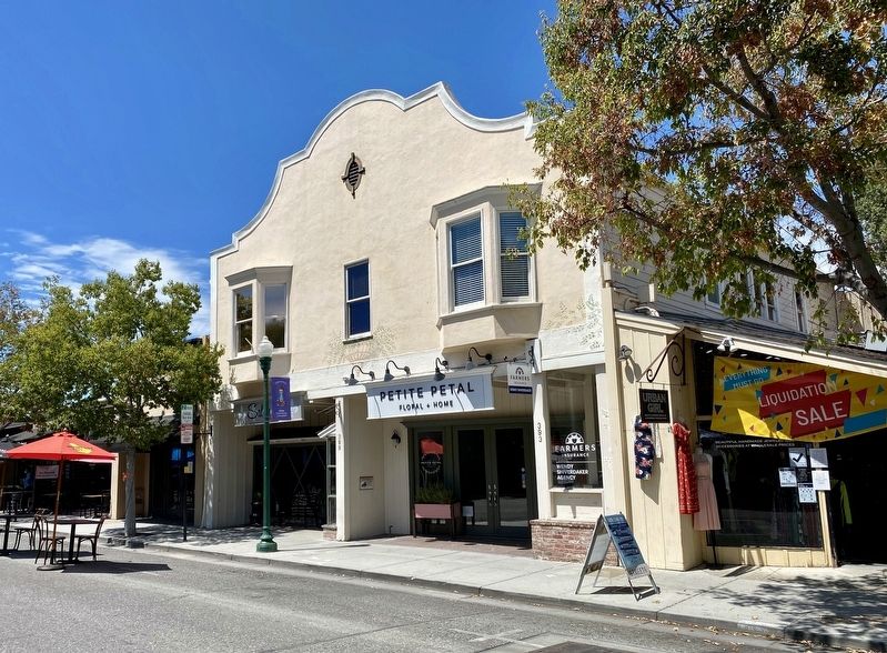
This California Mission Revival-style building,
constructed in 1905, is the second oldest
commercial structure in Campbell. It is typical
of the stores built in small towns in the early
1900s. Upper floor served as housing
quarters and . . . — — Map (db m154807) HM
John Cameron Gilroy
circa 1854
John Cameron Gilroy, native of Scotland, arrived in Spanish California in 1814, and became the first permanent English speaking settler. He married Maria Clara de la Ascencion Ortega, daughter of the family that . . . — — Map (db m68909) HM
Welcome to the
Gordon House
Home of the Rotary Club of San Jose
Hanford Lennox Gordon was born in 1846 and over his lifetime held a variety of positions as attorney, and officer for the Union Army during the Civil War, a farmer, and . . . — — Map (db m52126) HM
Acclaimed as "the prettiest and most attractive candy store on the Pacific Coast," O'Brien's Candy Store was more than a business to San Joseans, it was an institution—the natural place to stroll after a show or the ideal place to meet a friend. . . . — — Map (db m52163) HM
One hundred years ago, in the skies above this
monument, three soaring flights were made on
March 16th, 17th, and 20th, by an aeroplane-glider flown by Aeronaut and parachute daredevil, Daniel John Maloney, which had been
designed and built by . . . — — Map (db m100963) HM
Alexander Johnson donated the land for the first High School, City Park and the Catholic Church.
Leonard Joss, naturalist, landscaped the first city park, planted diverse flora all around Etna.
In honor of their generosity we dedicated . . . — — Map (db m58567) HM
Dedicated April 23, 1998
Halfway House
Added Station
Apr. 23, 1860 - Sep. 8, 1861
By
Sidney & Diane Schroeder Family
Ron Dupratt Family
John & Patty Greiner Family
Dixon Historical Society
American Legion Dixon Post #208 . . . — — Map (db m29940) HM
Dr. Armistead and Leland Parker, a pharmacist, practiced in Hills Ferry until the late 1890’s. In 1897 Dr. Armistead built the 2 story brick building. Leland Parker established Rexall Drug store on the street level. Dr. Armistead’s medical office on . . . — — Map (db m208550) HM
In 1913 the Women’s Improvement Club applied for a grant from the Andrew Carnegie Foundation to build a library. In 1918 the Newman free library joined the Stanislaus County Library system. The library was built in 1919 following WWI for $7,600, . . . — — Map (db m208312) HM
Newman’s 2nd hospital built in 1900 by J.A. Stratton. Doctors were J.A. Stratton, J.W. Reed and Ward. Wilmar Jensen, Attorney, moved his office from the IOOF building in 1955. Mark Jensen joined the firm in 1987, Jensen and Jensen, Attorneys. The . . . — — Map (db m209005) HM
The school was built in 1878 at Dutch Corners, moved to present site in the late 1890’s. Charlie Poy, who had cooked for the railroad crews from his kitchen tent, opened Newman’s first restaurant. Other restaurants followed including Las Flores . . . — — Map (db m208487) HM
In 1913, Peter J. Giovannoni built a garage for Frank Patchett’s new Ford dealership, known as the Patchett-Hendy Co. When the Ford company moved to a larger location, it became Frank Nunes Garage. Also the location for City offices, police . . . — — Map (db m213850) HM
The International Order of Odd Fellows building was a wooden structure built in 1892. It was replaced with the current building in 1928. After a 2009 fire, the Odd Fellows Lodge repaired the building. In 2011 the building was purchased by the City . . . — — Map (db m208404) HM
In 1886 the Lodge was organized in Hills Ferry. They moved to Newman in 1910 to the newly constructed 3 story building. Street level retail space, 2nd floor meeting rooms and 3rd floor the social hall. Knights of Pythias referred to their lodges as . . . — — Map (db m208394) HM
The Mission Revival Style building was built in 1921 by Tom Rose. The Old Rose Garage sold and repaired Studebaker automobiles. Upon his death in 1940, the business went to his son Albert A. Rose. He continued in business until the early 70’s. — — Map (db m208639) HM
In 1869 Simon Newman purchased a mercantile store in Hills Ferry from John Sharp. In 1888 he built a new store in Newman, to become the largest store between Stockton and Fresno selling dry goods, groceries, hardware and agricultural implements. The . . . — — Map (db m209009) HM
Built in the early 1900’s by Charles St. Clair for a hardware store. In 1931 he replaced the wooden structure with a brick building and a chalk rock house in back to store flammables. August 17, 1951 Ernie Prien bought the building and relocated . . . — — Map (db m208644) HM
Built in 1908 by J. Alves & Co., Jose Alves and Tom Enos, brother-in-law, from São Jorges, Azores. Stained glass windows depict scenes from the island. The hotel had 14 rooms and 1 bath upstairs and an office, lobby and saloon downstairs. It was one . . . — — Map (db m208400) HM
In 1896 Innis Sturgeon published the first issue of the paper from the Main Street location. Alvin Fleharty bought the paper in 1903. Fire destroyed the building in 1906 and years of records were lost. The business moved in 1929 to the present . . . — — Map (db m208712) HM
Dr James Dowle moved Dowle’s Sanitarium from Hills Ferry in 1893 to Fresno and Main Streets to become West Side Sanitarium. Newman’s 1st hospital was moved again in 1910 to its present location. It was a hospital until 1938 and medical offices until . . . — — Map (db m208401) HM
The 700 seat Art Deco Style theatre was built in 1940 by the Stephens-Hamm families. Opened August 1 featuring “The Boys from Syracuse”. Locally owned as operated as a movie theatre until 1984, when it became the cultural center of the West Side. — — Map (db m208397) HM
This cabin was first built in 1922 to commemorate the famed author’s presence in Tuolumne County during the winter of 1864-65. Sam Clemens had come over the mountains from Virginia City, Nevada, to San Francisco with his friend Steve Gillis. His . . . — — Map (db m154380) HM
Settled by Julian Smart who planted first garden and orchard in Tuolumne County in spring of 1849. Named for Colonel A.M. Jackson who opened first trading post in 1849. In 1850 was second largest town in county and gathering center for thousands of . . . — — Map (db m53523) HM
Dedicated April 23, 1999
SOLANO HOUSE
Added Station
Apr. 23, 1860 - Sept. 8 1861
By
First Northern Bank
William & Linda Bernheim
The Rotary Clubs of Davis
UC Davis - Cal Aggie Alumni Association
Davis Enterprise - McNaughton . . . — — Map (db m24606) HM
In 1895 pumps were installed at the confluence of the Yuba and Feather Rivers to protect the City of Marysville from the danger of flooding.
These pumps with a capacity to pump 18,265 gallons per minute, helped to keep Marysville dry during the . . . — — Map (db m17741) HM
Bob Howsam was born February 28, 1918 in Denver, Colorado. His parents, Lee and Mary, moved the family to La Jara in 1926 to produce honey. Bob was an All Valley basketball player for the La Jara Wildcats in 1936. He attended the University of . . . — — Map (db m294492) HM
Known to millions of fans as “Mr. Baseball,” Branch Rickey was voted the “most influential person in sports in the 20th century” by ESPN’s Sportscentury Panel. Perhaps foremost among his accomplishments, Mr. Rickey is credited with breaking the . . . — — Map (db m283900) HM
The freedom memorial In honor of those men and women of the United States Armed Forces, who have fallen and served in The Global War on Terrorism.
They were fathers, mothers, sisters, brothers, sons, daughters.
Freedom from terror has a . . . — — Map (db m251799) WM
In 1868 Cañon City residents began building a penitentiary for the Colorado Territory. The 40-cell prison opened to receive convicts in June 1871. By 1899, the penitentiary housed about 400 inmates. Before a wall was built around the prison, . . . — — Map (db m281694) HM
Silent Movie Era From 1911 to 1914, the Selig Polyscope Company and the Colorado Motion Picture Company shot movies in and around Cañon City. The films starred silent film actors such as Tom Mix, Myrtle Stedman, and Josephine West. The . . . — — Map (db m281696) HM
Raynolds-McGee Block (1883) Construction of this two-story Gothic Revival building was completed in 1883. Frederick A. Raynolds owned the east half which housed the Fremont County Bank. William B. McGee owned the west half, occupied . . . — — Map (db m281698) HM
In 1882 P.H. Smith settled in Grand Lake. He built a hotel and also operated a sawmill, carpentry shop, and a large resort. Around 1915, along with the Alfred Eslick family, he built this Motor Court, designed to accommodate both visitors and their . . . — — Map (db m129857) HM
In the 1940s, farmers were able to
draw water from the vast
underground Ogallala Aquifer using
deep water wells. This created
opportunities for production of new
"thirstier" crops and improved
nourishment of plants which in turn
brought . . . — — Map (db m251706) HM
As the Dust Bowl settled down in the
1940s, a new storm was brewing for
the Nation. This storm created what
many have called the "Greatest
Generation" and threw virtually the
entire world into chaos. No one was
left untouched, including . . . — — Map (db m251704) HM
Corn planting in the 1930s or 1940s.
No-till corn planting in the 2010s;
note the difference in soil
disruption.
The wheat threshing machine
separated the wheat berry from the
plant. Cut wheat was hauled from
neighboring fields to the . . . — — Map (db m251707) HM
When the early settlers arrived in
eastern Colorado around the middle
of the nineteenth century, they
found Native Americans occupying
the plains The eastern plains were
home to the Arapahoe and Cheyenne
tribes occasional visits . . . — — Map (db m251696) HM
As the Native Americans and buffalo
disappeared from the Great Plains,
vast herds of cattle took their place.
The open range provided excellent
native grass for the cattle to forage
on. Without fences to confine them,
the herds would range . . . — — Map (db m251699) HM
The forces of nature have been
creating energy since the beginning
of time. People of each era seem to
find their own new ways to make use
of God's mysterious powers.
Traditional windmills were the
fastest way to pull water from . . . — — Map (db m251750) HM
Approximately 230 feet below where
you are standing is a geological
formation called the Ogallala
Aquifer. This underground water
basin is located beneath portions of
eight states. The volume of water
varies depending on rainfall and
usage . . . — — Map (db m251712) HM
The present day City of Burlington
was established in 1888 as towns
were needed along the Rock Island
Railroad track during its
construction. Burlington was in the
works to become a junction town;
however plans for additional railroad
lines . . . — — Map (db m251700) HM
Joseph Antoine Janis was born in St. Charles, Missouri, in 1824. He made a claim on the Cache la Poudre River in 1844, intending to return later to build a home. In the summer of 1859, Antoine Janis, his Oglala wife First Elk Woman and their . . . — — Map (db m105248) HM
This two-story cabin is a classic example of American frontier log construction. Sixty-three year old Elizabeth "Auntie" Stone and her second husband Lewis arrived in this area in 1864. The Army granted them permission to build a private . . . — — Map (db m51972) HM
In the late 1800's the South Platte River Valley was a treeless wilderness covered in sagebrush, prairie grass and scrub willows. Great herds of antelope and buffalo roamed the windswept plains. Those continuing further west referred to this . . . — — Map (db m288864)
Pike’s Tower is dedicated to the explorer, Brigadier General Zebulon Pike, for whom Pike’s Peak was named. He camped at this site on November 13, 1806 with his expedition group while heading west across Colorado. He was a U.S. Army officer who led . . . — — Map (db m289663) HM
Southington
French General Jean Baptiste Donatien de Vimeur, comte de Rochambeau, and thousands of French ground and naval forces arrived in Newport in July of 1780 to assist the Americans in the War for Independence. After wintering in . . . — — Map (db m165804) HM
Stepney
1794
Birdsey’s Plain /
Stepney Cemetery
Noah and James Burr, Jr. donated this land for a burial ground. Over 1,400 men, women & children are interred including many of the areas first settlers. Veterans include: . . . — — Map (db m25329) HM
We whose names are hereunder written, intending by God’s gracious permission to plant ourselves in New England, and if it may be, in the southerly part about Quinnipiack, we do faithfully promise each to other, for ourselves and our families and . . . — — Map (db m266473) HM
The Post Road Bridge
1807 Westport was a prosperous shipping community with wharves, docks, and shipyards along both sides of the Saugatuck River. The first Post Road Bridge was owned and built by the Connecticut Turnpike Company, a public . . . — — Map (db m30644) HM
Wilton Veterans Memorial
Honoring
Those who served
Revolutionary War 1775 – 1784
War of 1812 1812 – 1814
Mexican War 1846 – 1848
Civil War 1861 1865
Spanish – American War 1989 – 1902 . . . — — Map (db m32254) WM
In 1938 the Wilmington Board of Education proudly dedicated a new vocational high school on the northwest corner of Market and 14th Streets. State and city dignitaries attended the ceremony that officially opened a school that for the next three . . . — — Map (db m131160) HM
Awarded the John F. Newnam Service Award, The Rotary Club of Wilmington's highest honor, in July, 2019, Jon Whitcomb embodied the Rotary motto "Service Above Self." His fellow Rotarians have dedicated this music circle in Jon's memory with the . . . — — Map (db m216005) HM
Early in the 1890s, Civil War Union veterans claimed a small corner of Brandywine Park as a place to congregate in good weather. The familiar sight of the old soldiers sitting regularly in that area led people to call the spot "Old Soldiers' . . . — — Map (db m169002) HM
Inspired by the simple idea of combining fellowship and service, Paul Harris pioneered the service club movement with the founding of Rotary International. Rotary fulfilled his dream of a worldwide organization of business and professional people . . . — — Map (db m92025) HM
The All-American drink was introduced to Citrus County in the early 1900's. W.T. Baxley acted as a sub-bottler to the Tampa Coca Cola Bottling Company, and began bottling it in Hernando in 1906. Empty bottles were washed in Hernando Lake, then . . . — — Map (db m117170) HM
The Masonic Temple for Citrus Lodge #118, F. and A.M., was built on Main Street and dedicated in 1910, ready for occupancy in January, 1911. A splendid three-story brick building costing $17,285, the most costly building in the county. Originally . . . — — Map (db m122748) HM
This house was built in 1903 for George Carter, Citrus County's third sheriff. The Carter House was the first house in Inverness to have a bathroom and was one of the first 13 buildings in Inverness to be “wired up” when electricity came . . . — — Map (db m126060) HM
Awarded for
Wounds or Death as Result of an Act
Of an Opposing Armed Force
Dedicated to
All Those Who Shed Their Life’s Blood
In the Cause of Freedom — — Map (db m177723) WM
Buried herein are twenty-three Royal Air Force Cadets who died while in training at U.S. flying training fields in South Florida during W.W.II. — — Map (db m110864) HM
The 25-ton steam locomotive was manufactured for the W.W. Cummer & Sons Lumber Company in Dade City, Florida. The locomotive was built in 1911 in Pittsburg, Pennsylvania by the H.K. Porter Company.
It was used to haul pine and cypress logs in Pasco . . . — — Map (db m311484) HM
Captain Joseph Fry was born in Tampa (Fort Brooke) June 14, 1826. As a graduate of the U.S. Naval Academy, he served with the Navy throughout the world. When the Civil War broke out, Fry fought with courage and capacity for the South in the . . . — — Map (db m129943) HM
At this site on a small stream was located the first settlement of Tampa Bay. Its inhabitants were Spanish-Cuban fishermen and straw-hat makers. It is believed they settled here toward the end of the eighteenth century, during Spain's second rule . . . — — Map (db m69853) HM
This memorial highway is reverently dedicated as a “Road of Remembrance” to those who gave their lives for liberty in the World War 1917-18 by the people of Tampa and Hillsborough County through the Tampa Rotary Club - 1921 - James Adams • . . . — — Map (db m214933) WM
On this site was published the historic newspaper “Cuba,” dedicated to the cause of Cuban Independence. “Cuba” was the successor of “El Crítico De Ybor City.” Its editor was Ramon Rivero y Rivero, a great revolutionist. In 1891 Rivero . . . — — Map (db m215489) HM
The first citizen of Ybor City was Gavino Gutierrez, Spanish civil engineer.
Gutierrez investigated the area in 1884 as a site for a guava processing plant. The guava plant was never erected, but on the strength of Gutierrez recommendations his . . . — — Map (db m129893) HM
The first violent death in the Latin Quarter occurred in this vicinity when a pistol duel was fought between two Cuban cigarmakers. Their nicknames were "Teclo" and "Matancero." "Teclo" was killed instantly in the exchange. It is said the duel was . . . — — Map (db m129944) HM
Desde esta escalinata
En el año 1893
José Martí
Apóstol de la Libertad
de Cuba
Con elocuentes palabras
pidió a los tabaqueros
Cubanos emigrados que le
ayudasen a conquistar la
independencia de su país,
aportando hombres, . . . — — Map (db m14431) HM
Paulina Pedroso was one of the great women patriots of Cuba. After an attempt on the life of Jose Marti, the Pedroso House became his refuge.
Whenever Marti stayed here the flag of the budding Republic of Cuba fluttered outside. Evenings, the . . . — — Map (db m31931) HM
Vicente Martinez Ybor led the procession of cigar manufactures to Tampa making it the largest clear Havana cigar manufacturing center in the world. Here, on Dec. 22, 1886, he completed his country villa.
Ybor entertained lavishly with "fiestas . . . — — Map (db m150562) HM
Soon after the founding of Ybor City, Cuban, Spanish, and Italian immigrants established comprehensive health maintenance organizations. For small weekly dues they received medicines, hospitalization, and medical services.
On June 18, 1888, Don . . . — — Map (db m130180) HM
The intersection of Seventh Avenue and Twentysecond Street was a sandy cross-road connecting three army encampments in the Ybor City area during the Spanish-American War.
At this cross-road was located a water-trough where the Rough Riders . . . — — Map (db m33805) HM
The Mirta Hook and Ladder Volunteer Fire Station was established on this site. The station was named in honor of the youngest daughter of Don Vicente Martinez Ybor, founder of Ybor City. Capt. Frank Puglisi headed the fire fighters. Volunteer . . . — — Map (db m31887) HM
On February 23, 2005, the five Rotary Clubs of Indian River County joined together to break ground on this Centennial Fountain.
The fountain was built to commemorate Rotary International’s 100th Anniversary and revive the original Rotary . . . — — Map (db m185888) HM
WAVES
Women Accepted for Volunteer Emergency Service
The woman’s branch of the United States Navy was established on 30 July 1942 by President Roosevelt this authorized the U.S. Navy to accept women into . . . — — Map (db m246677) HM WM
The Wardlaw-Smith House was erected in the early 1860's for Benjamin F. Wardlaw, a prominent local citizen. Following the Civil War Battle of Olustee in February, 1864, it served as a Confederate hospital. This fine example of Greek Revival . . . — — Map (db m17745) HM
In 1918 Charles Deering constructed this bridge to cross Cutler Creek on the way to his retirement home. At the time this accessway was called "Old Cutler Road". Deering relocated it from its original location inside the natural areas of his . . . — — Map (db m79320) HM
(side 1)
In 1838, the United States Congress granted a township of land in the southern extremity of Florida to noted horticulturist Dr. Henry Perrine and his associates. This land was to be used in experiments aimed at introducing foreign . . . — — Map (db m73442) HM
Jefferson Browne attended school in Key West but graduated from Kenmore University High School in Amherst, Virginia, in the mid 1870’s. He became a lighthouse keeper, at Fowey Rocks Lighthouse for fifteen months where he spent his spare time . . . — — Map (db m222934) HM
To the memory of Dr. Howard Atwood Kelly of Baltimore, Maryland, one of the founders of Johns Hopkins Hospital and medical school. He was a great surgeon, teacher and medical authority, and above all, a Christian gentleman.
Dr. Kelly, in 1927 . . . — — Map (db m66834) HM
This site was home to Dr. Henry Nehrling (1853-1929), an internationally renowned horticulturalist, naturalist, botanist, ornithologist, and writer known as the "patron saint of Florida gardens." Here, and at his later Naples gardens, between 1886 . . . — — Map (db m226365) HM
Dedicated to the Residents of the Town of Palm Beach
who served their country during World War II
December 7, 1941 – August 14, 1945
With special recognition to the West Palm Beach Chapter American Red Cross
Dedicated 1985
Yvelyne de . . . — — Map (db m292615) WM
Welcome This memorial is dedicated by the families and friends of Winter Springs.
To all Veterans who have served to protect our great country.
Please take time to reflect, upon our Veterans sacrifices, to honor their courage, and to more . . . — — Map (db m169819) WM
The Old Kings Road crossed north to south near this site. First originated as an Indian trail, later improved by the Spanish, and then constructed by the British as a road in 1763-1773 to connect St. Augustine and New Smyrna, Florida. Improved by . . . — — Map (db m101665) HM
The Rotary Club of Fitzgerald was chartered on December 21, 1936, through the sponsorship of the Columbus Rotary Club. The organizational meeting was held December 1, 1936 in the office of J. C. McDonald. There were twenty-six charter members. S. . . . — — Map (db m191137) HM
On January 5, 1914, the Rotary Club of Savannah met for the first time at the DeSoto Hotel. Founded by John S. Banks and a group of local businessmen, this was the second Rotary club established in Georgia. The nation’s first service club, Rotary . . . — — Map (db m108958) HM
On the occasion of the 100th anniversary of his death, the Rotary Club of Savannah is pleased to erect this marker honoring our founder and first club president, John Sherer Banks.
John Banks was a young local businessman (piano shop owner) . . . — — Map (db m210672) HM
This is the site of
Confederate Air Force
Pad No. 1
Holding 98', this giant missile was dismantled in California and flown to Warner Robins Air Force Base. The missile was then transported along I-75 to Cordele.
The . . . — — Map (db m55339) HM
Brick Manufacturing Area
Operated by Angus Ferguson
The saw mill, further upstream, and the brick making facility
were both run by Angus Ferguson. His company was known
as Ferguson's Merchants Mills. Using slave labor, . . . — — Map (db m261211) HM
945 entries matched your criteria. Entries 101 through 200 are listed above. ⊲ Previous 100 — Next 100 ⊳