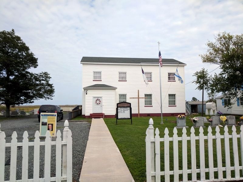
The New Testament Congregation was dedicated on Easter Sunday, 1957, and occupies the same site used for the Chautauqua tent in the 1920's.
The New Testament Mission House was once the home of teacher Alfred Benson (1893-1963) who taught at . . . — — Map (db m207732) HM
Factory Road was originally named New Road. It is said to have been built by Henry Frazier, a Black man, by hand, around the time of the Civil War. In 1919, George Lawson of Crisfield, MD in association with the Kegan, Grace & W. Shirt Makers Guild . . . — — Map (db m106988) HM
Owner Milton Parks has provided warm hospitality to boaters for decades. His marina serves local watermen, commercial and recreational boat traffic.
(captions)
Milton Parks on his scooter - Kaye, 2005
Oyster Buy Boats at Park's . . . — — Map (db m106963) HM
The new house on the corner of Garman Road and Main Ridge is the site of the former Peter S. Crockett Store, later Daughtery & Ward, and then Haynie Grocery.
It had a two-story front porch and was featured in many old photographs. . . . — — Map (db m106972) HM
Charles "Puge" Charnock (1936-2003) was one of Tangier's most beloved watermen. He not only was in the crab shedding business, but also sold ice and bait to the watermen. From his dock, and the adjoining County Dock, Tangier's famous shell crabs . . . — — Map (db m299429) HM
Spanky's Place, now an ice cream parlor with a 50's theme, is one of many businesses to occupy this site. These include Michael Thomas's store that sold stoves and propane, Jolly Jim's Restaurant, Nice's Place, and the Roadside Restaurant. It was . . . — — Map (db m106966) HM
The most prominent of the island's buildings, Swain Memorial United Methodist Church is easily recognized as the focal point of Tangier.
Built in 1899 on the site of the island's second church (1842), it is the center of the Tangier's . . . — — Map (db m39998) HM
Tangier Beach is a 1.5 mile long pristine sand beach, accessed over a narrow wooden pedestrian only bridge, and the best site for watching the island's glorious sunsets
Off the end of the beach at the southwest tip stands the current . . . — — Map (db m299450) HM
The location of the first school on Main Ridge (1871) is unknown, although at the turn of the 20th century Canaan Ridge also had its own school.
The second school, built in 1905, stood at the site of the present day basketball court. In 1930 . . . — — Map (db m299451) HM
Mailboat Harbor replaced Steamboat Harbor in the 1930’s as the age of steamboats came to a close. The harbor was first dredged in 1922, from the Eastern side. In 1967, the harbor was dredged through to the Western side of the island. This was a . . . — — Map (db m39554) HM
This is the site of the former Lewis Crockett Store. It is also the site where in 1936, the Goodyear Blimp arrived with provisions to feed the islanders, who had been frozen in for over two months during a record freeze.
The Visitors Center . . . — — Map (db m106969) HM
The island was visited in 1608 by Captain John Smith, who gave it the name. A part was patented by Ambrose White in 1670. It was settled in 1686 by John Crockett and his sons’ families. In 1814, it was the headquarters of a British fleet ravaging . . . — — Map (db m46705) HM
In honor of the men and women of Tangier Island who have served their country faithfully since World War II
★ Eskridge, Warren R. •
★ Shores, Nolan L. •
★ Crockett, James C.
Parks, Edward F. •
Armstrong, Jack O. • . . . — — Map (db m107036) WM
In honor of the men and women of Tangier Island who have faithfully served their country.
★ Brandon Neil Parks
A. Clyde Pruitt, Sr. •
Lorie Pruitt •
Milton Parks •
John Holdgrafer •
Charles "Butch" Smarr •
L. Wade Creedle, . . . — — Map (db m107037) WM
In honor of the men and women of Tangier Island who faithfully served their country in World Wars I and II
World War I
★ Crockett, William L. •
★ Crockett, Tubman
Bradshaw, J. Gosten •
Bradshaw, Robert J. • . . . — — Map (db m107033) WM
[First paragraph cannot be interpreted.]
Black Skimmer (Rynchops niger) is black above and white below with a thick black-tipped red-orange bill. It is very long-winged, and is graceful and buoyant in flight, with the head always . . . — — Map (db m299447)
The Tangier Volunteer Fire Department was established in 1964 and moved to this location in 1983.
Fire is especially dangerous on a small island. where wooden houses are close together, allowing fire to spread quickly, especially when fanned . . . — — Map (db m106986) HM
The Telephone Building was built in 1966 by Grover Charnock when radiotelephones were finally replaced with a microwave tower.
In front of this is a new home, built on the site of the former Grand Theater, built in 1929 by Gordon Daley, and . . . — — Map (db m97690) HM
The Amanda Wallace Pruitt House was also the home of Reverend James C. Richardson after his resignation from the Methodist church.
He founded the New Testament Church, which met here from 1948-1956. Services were held in the living room and . . . — — Map (db m106996) HM
The Connorton House was the home of the town Sergeant, Bud Connorton.
On Sunday April 11, 1920, Sergeant Connorton shot and wounded 17 year old Roland Parks. He was trying to enforce a town ordinance that forbade "loafing on store porches and . . . — — Map (db m39954) HM
The Doctor's House was owned consecutively by doctors Samuel Oglesby, William Daisey, Bache Gill, and Charles Gladstone. Dr. Gladstone never lived there, but boarded next door in the Sidney Crockett House.
Dr. Gladstone's former office still . . . — — Map (db m39951) HM
The Double Six Sandwich Shop is where the watermen meet at 3:00 AM for "smokes and coffee" before heading down to the docks to the day's work.
Named for the game of Dominos, the shop is open for sandwiches year-round, and was often considered . . . — — Map (db m39683) HM
The Edward Crockett House was formerly the home of "Sugar Tom" Crockett (1833-1905) the Island's first historian, and author of Facts & Fun, the first written history of Tangier Island. It later served as a hotel and the office of Dr. W.O. . . . — — Map (db m106967) HM
The Emily Pruitt House was home to the island's sail-making seamstress, a critically important job before the invention of motorized boats. — — Map (db m106994) HM
The John Thomas House marks the dividing line between the old Thomas and Wallace family lands.
At the end of the 19th century, these two families owned almost all of the land on the western side of the island. — — Map (db m106991) HM
The Joshua Pruitt House is one of the oldest on Tangier.
Joshua Pruitt (1866-1949) and his wife Amanda took in boarders, teachers, and held worship services in their front yard.
Pruitt traveled to Washington, DC, during the Great . . . — — Map (db m106968) HM
Miss Minnie and Capt. Charlie raised eight children in this house. In order to accommodate the entire family at a single table, Capt. Charlie commissioned Henry Jander to build them a table capable of seating ten people. Later, one son, Orville, . . . — — Map (db m106989) HM
Joshua Thomas (1776–1853) became a skilled waterman from the in his youth and ferried clergymen from the mainland to the islands of the Chesapeake Bay. He converted to Methodism about 1807, was licensed as an exhorter (or lay preacher) and was . . . — — Map (db m97688) HM
Patrick Benson, a ship's captain from Dublin, Ireland, purchased this land in 1879. The middle section of house was completed in 1889. The front section with porch and back section with kitchen and outbuilding were added over the years, but . . . — — Map (db m106977) HM
The Peter Dise House is one of the oldest on the island and was moved from the "Uppards," the now unoccupied marsh north of the harbor.
There were originally four fresh water wells on the island, two on Maine Ridge, one on Canton Ridge and one . . . — — Map (db m39953) HM
The Peter Williams House is one of the island's oldest and largest homes and was once decorated with beautiful "gingerbread."
Williams was the original owner and operator of the grocery store across the street. — — Map (db m299428) HM
The Sydney Wallace House is one of the Island's most admired. Built in 1904 and restored in 1995 by Wallace's grandson, it now operates as the Bay View Inn.
(caption)
Sydney Wallace House - National Geographic, 1973 — — Map (db m106993) HM
Wading birds with long legs, necks and bills feed on aquatic animal life along the shore and marsh at low tide. Some stand still as a statue, others probe the mud with their bill or feet. These birds are common on Tangier.
Great Blue . . . — — Map (db m299448)
For almost 250 years the people of Tangier have wrested a living and a lifestyle from the waters that surround them. Most of their days have been occupied with family, work, church, and the other normal pursuits in which we all engage. But they . . . — — Map (db m97723) HM
For almost 250 years the people of Tangier have wrested a living and a lifestyle from the waters that surround them. Most of their days have been occupied with family, work, church, and the other normal pursuits in which we all engage. But they . . . — — Map (db m106961) HM
For over 250 years, the people of Tangier have wrested a living and a lifestyle from the waters that surround them. Most of their days have been occupied with family, work, church, and the other normal pursuits that we all engage. But they have . . . — — Map (db m299427) HM
For over 250 years, the people of Tangier have wrested a living and a lifestyle from the waters that surround them. Most of their days have been occupied with family, work, church, and the other normal pursuits that we all engage. But they have . . . — — Map (db m299431) HM
Landowner, successful business woman manager, champion of American Independence. Daughter of Naomi and Francis Makemie, founder of organized American Presbyterianism. — — Map (db m7835) HM
Five miles west was the home of the Rev. Francis Makemie, founder of Presbyterianism in the United States. About 1684, Makemie established in Maryland the first Presbyterian Church. Later he moved to Accomac and married. He died here in 1708. — — Map (db m7830) HM
Erected in Gratitude to God And in grateful, remembrance of his servant and minister Francis Makemie, who was born in Ramelton, County Donegal, Ireland, A.D. 1658(?) was educated at Glasgow University, Scotland, and came as an ordained Evangelist to . . . — — Map (db m7838) HM
Welcome to Makemie Monument Park
Designated as A Virginia Historic Landmark September 6, 2006.
And placed on the National Register of Historic Places February 15, 2007. — — Map (db m7833) HM
Commemorates the belief that in this ancient family cemetery were buried near the remains of Francis Makemie, those of his wife Naomi, his daughters Elizabeth and Madame Anne Holden, and his father-in-law, William Anderson. Also those of John . . . — — Map (db m7840) HM
Wallops Island is, home to several suborbital and orbital launch pads. NASA selected this site due to its low population of people and remote location on the East Coast. Thousands of people view scientific, research, and cargo resupply launches . . . — — Map (db m205124) HM
The Aerobee 150 (to the right) was a liquid-fueled sounding rocket that was used at Wallops. This rocket could reach altitudes of 170 miles while carrying 150 pounds of equipment. Design changes and improvements to this rocket led to the development . . . — — Map (db m205123) HM
First launched in 1982, Black Brant IX powered rockets have carried their fair share of experiments, including telescopes, scientific instruments, and technology tests. Black Brant IX's are launched all over the world and perform well in extreme . . . — — Map (db m205109) HM
Dedicated in honor of
Dr. Robert L. Krieger
1916 - 1990
Leader of Wallops from 1948-1981, he guided the facility through years of expansion and research, He was very involved in educational and civic activities on the Eastern . . . — — Map (db m205051) HM
Little Joe rockets paved the way for Project Mercury, NASA's first manned spaceflight program. Seven unmanned Little Joe rockets were launched from Wallops from 1959-1961 to test an escape system for the Mercury capsule. The tests done at Wallops . . . — — Map (db m205115) HM
The Wallops Island Flight Facility was established in 1945 by the National Advisory Committee for Aeronautics and is one of the oldest launch sites in the world. This facility was built to conduct aeronautical research using rocket-propelled . . . — — Map (db m63666) HM
Scientific instruments ranging from 10-100 pounds were carried in the nose cone of this two-stage rocket from 1956-1976. The combination of the Nike booster and the second stage Cajun could reach altitudes of 104 miles. The Nike-Cajun was used to . . . — — Map (db m205062) HM
In the 1970's, the Army had a surplus of Orion motors. NASA saw potential in these unused motors for scientific exploration. Nike-Orion sounding rockets were solid-fueled, two-stage sounding rockets created with a Nike and an Orion motor. These . . . — — Map (db m205117) HM
The visitor center displays NASA’s past, present and future projects, as well as, Wallops flight facility’s role in Aeronautical and Space research. The NASA Goddard Space Flight Center’s Wallops flight facility was established in 1945, and is one . . . — — Map (db m95122) HM
Albemarle County. Albemarle County was formed in 1744 from Goochland County and named for William Anne Keppel, the second Earl of Albemarle, titular governor of Virginia from 1737 to 1754. A portion of Louisa County was later added to . . . — — Map (db m4030) HM
Built during the nineteen-thirties, Rockfish Gap Country Store was first
used as a peach packing shed by Chesly A. Hayden. Not only was it the
biggest warehouse distribution center in the county, but it also ranked
among the top three in the . . . — — Map (db m234295) HM
Albemarle County. Albemarle County was formed in 1744 from Goochland County and named for William Anne Keppel, the second Earl of Albemarle, titular governor of Virginia from 1747 to 1754. A portion of Louisa County was later added to . . . — — Map (db m21585) HM
Extending from the Orange County line on the north to the outskirts of Charlottesville with the Southwest Mountains forming its spine, this historic district encompasses more than 31,000 acres and contains some of the Piedmont’s most pristine and . . . — — Map (db m40775) HM
The Staunton and James River Turnpike ran
through here at Batesville and stretched for
43½ miles from Staunton to Scottsville.
Construction began in 1826 and was completed
by 1830. The turnpike provided a direct
route for Shenandoah Valley . . . — — Map (db m21696) HM
The Rothwell Family of Albemarle County Virginia.
Claiborne one of the first of the Rothwells to live in this county, was born about 1741 as reported in The Virginia Advocate, Saturday Oct. 11, 1828 and “died on Oct. 6 in his 87th . . . — — Map (db m3996) HM
The original house was built in 1765 by Thomas Walker, explorer and pioneer. Tarleton, raiding Charlottesville to capture Jefferson and the legislature, stopped here for breakfast, June 4, 1781. This delay aided the patriots to escape. Castle Hill . . . — — Map (db m22439) HM
On 3 Sept. 1963, nine years after the U.S. Supreme Court declared racial segregation of public schools unconstitutional, 26 African-American students desegregated Albemarle High, Stone-Robinson Elementary, and Greenwood School. With the . . . — — Map (db m170122) HM
Such relationships ranged from acknowledged affairs that...were familial in every sense but a legally recognized one to brutal acts of rape and sexual assault where slave owners showed the inhumanity for which slavery was notorious. . . . — — Map (db m231159) HM
Plantation industry at Highland included a threshing machine, grist mill, saw mill, blacksmith shop, and wool spinning. Nonetheless, James Monroe expressed frustration that Highland "has run me into debt considerably."
By the 1820s, cotton . . . — — Map (db m261921) HM
Archaeological investigations in 2014 revealed buried architectural debris in this area, which led to the discovery of well-preserved stone foundations. Further research identified these as the remains of the Monroes' main house.
Artifacts . . . — — Map (db m261922) HM
Ash Lawn - Highland
Home of James Monroe from 1799-1823
Dedicated on July 20, 1985
by
Virginia Daughters of the American Revolution
State Regent
Mrs. G.E. Honts, Jr. — — Map (db m63671) HM
In 1814 a ditch 500 yards long was dug to keep grazing animals off the west lawn.
The rails that were laid across the banks reminded a visitor in 1823 of "a common post and rail fence, blown down across a ditch." — — Map (db m100002) HM
George Rogers Clark was born a mile northeast of here on 19 Nov. 1752. He grew up on a farm in Caroline County. Clark explored the Ohio River Valley, fought in Dunmore's War in 1774, and helped convince the General Assembly to organize Kentucky as a . . . — — Map (db m165405) HM
When we came from Virginia we brought one daughter with us, leaving the dust of a son in the soil near Monticello. Madison Hemings, 1873
Many burial grounds for enslaved people remain unknown. Separation of families . . . — — Map (db m261930) HM
Wood charcoal fueled the forges in the nailery on Mulberry Row and heated the stoves in the kitchen. Charcoal was stored under lock and key in wooden sheds that once stood here. Built about 1794, these "coal sheds" likely resembled temporary . . . — — Map (db m100442) HM
Despite the horrors of slavery, African Americans forged enduring family and community connections, and cultural and spiritual practices. The Contemplative Site is a space to reflect upon their lives and legacies.
Thomas Jefferson held at . . . — — Map (db m231012) HM
Mulberry Row’s buildings have all but disappeared—only the remains of four survive. Before re-creating lost buildings and roads, we look at information from many sources. How do we know about this important place and the history of its people, . . . — — Map (db m80863) HM
Edgar Allan Poe (1809-1849)—writer, poet, and
critic—was born in Boston, Mass. Orphaned at a
young age, Poe was raised by John and Frances Allan of Richmond. He attended schools in
England and Richmond before enrolling at the University of . . . — — Map (db m8765) HM
William Randolph patented the Edgehill plantation just to the north, in 1735. His grandson, Thomas Mann Randolph, married Thomas Jefferson's daughter Martha, acquired Edgehill in 1792, and was later governor of Virginia. The couple built a frame . . . — — Map (db m170657) HM
Isaac Granger Jefferson worked the forge in the original building on this site, which housed a "storehouse for iron" in 1796, a short-lived tinsmithing operation, a small nail-making shop, and also served as quarters for enslaved people. The use . . . — — Map (db m231059) HM
Born in slavery at Monticello on July 4, 1826, the day of Thomas Jefferson's death, Henry Martin worked at the University in various capacities from about 1847 until his retirement in 1910. In late 1868 or early 1869, he was employed as head . . . — — Map (db m75526) HM
Historic Michie Tavern, established in 1784 by Scotsman William Michie, served as a social center of its community and accommodated travelers with food, drink and lodging.
◇ Highlights of the Tavern Tour
◇ . . . — — Map (db m170646) HM
The Eagle. Peacemaker. Tecumseh. Bremo. Wellington. Diomede. These were the six carriage and saddle horses, plus one mule, stabled here in 1821. As many as 30 riding and carriage horses, workhorses, and mules were stabled at various locations on . . . — — Map (db m100157) HM
Master carpenter James Dinsmore oversaw construction of this Ice House to Jefferson's design in 1802. Enslaved and hired workers filled it each year between November and February with ice cut from the nearby Rivanna River, shallow ponds, or snow . . . — — Map (db m68174) HM
Iron casting of a mileage marker on Highway 40, the first federally-supported interstate roadway, created during James Monroe's presidency.
This marker was given by the state of Pennsylvania to Pennsylvania native Jay Winston Johns, who . . . — — Map (db m261925) HM
In 1788 James Monroe purchased an 800-acre farm here to be close to his friend Thomas Jefferson and to establish a law office. In 1799 the Monroes moved to their new Highland plantation adjacent to Monticello and sold the first farm. In 1817 the . . . — — Map (db m8762) HM
Here in 1774, Thomas Jefferson and Philip Mazzei planted Virginia's first commercial vineyard, intending to export their wine back to Europe. The Vineyard was abandon in 1776 with the advent of the Revolutionary War. Jefferson's efforts to grow . . . — — Map (db m188548) HM
Jefferson's elaborate design for Monticello could not have been achieved without the superior craftsmanship of hired free and enslaved woodworkers working closely together. Joiners, the most skilled, produced Monticello's classically inspired . . . — — Map (db m230977) HM
Here on December the tenth MDCCCLXIX the Kappa Sigma Fraternity was founded by William Grisby McCormick • George Miles Arnold • John Covert Boyd • Edmund Law Rogers • Frank Courtney Nicodemus. Manet Mansuraque Est. — — Map (db m8812) HM
... architecture is my delight, and putting up, and pulling down, one of my favourite amusements.
Thomas Jefferson quoted by Margaret Bayard Smith, 1809
Thomas Jefferson shaped American architecture with his neoclassical designs . . . — — Map (db m231048) HM
Not far from the Tavern on its original site, the Michie family once owned and operated a mill and general store. At the turn of the century, their mill fell from decay. The Meadow Run Grist Mill from nearby Laurel Hill, Virginia was relocated to . . . — — Map (db m170643) HM
Michie Tavern is recognized as a Virginia Landmark for its leading role in the 1920's Preservation Movement. In continuing efforts towards preservation, this historic attraction has worked towards saving significant rural Virginia structures. . . . — — Map (db m170644) HM
Every article is made on his farm; his negroes are cabinet makers, carpenters, masons, bricklayers, smith, etc. Duc de La Rochefoucauld Liancourt, 1796
You are standing on Mulberry Row, a road once lined with more . . . — — Map (db m68171) HM
Jefferson attempted to create an efficient plantation based on new approaches to agriculture and manufacturing. To realize his goals, dozens of enslaved and free workers lived and worked here on Mulberry Row. Jefferson added a series of dwellings . . . — — Map (db m100132) HM
Jefferson set up a nail-making operation in 1794 to provide income until he could “put my farms into a course of yielding profit.” He calculated the nailers’ daily output, the waste of nailrod, and profits. In its first years, the . . . — — Map (db m80862) HM
Although both the North and South Pavilions were elements in Jefferson's designs of the 1770's for Monticello, it was not until 1808 that his scheme was fully realized with the completion of this structure. After Jefferson's daughter Martha and . . . — — Map (db m231029) HM
What you see here is a reconstruction of the North Terrace wing. The original wing, built 1801-05, housed Jefferson's carriages and the horses and carriages of visitors; most of Jefferson's horses were stabled at the east end of Mulberry Row. Horses . . . — — Map (db m100469) HM
This was the general site of the "old nursery," where Jefferson grafted and sowed the seed of special garden plants. He propagated thirteen kinds of shrubs, forty—one species of ornamental trees, twenty—six vegetable varieties, six kinds . . . — — Map (db m100003) HM
Virginia's virgin forest provided materials for the settlers' most basic shelter. Centuries ago, first growth trees were felled and the wood hewn to form this single-room log cabin in Piney River, Virginia, 45 minutes south of here. The structure is . . . — — Map (db m53613) HM
Virginia's virgin forest provided materials for the settlers' most basic shelter. Centuries ago, first growth trees were felled and hewn to form the single room log cabin in Piney River, Virginia, 45 minutes south from here. This 18th century . . . — — Map (db m170649) HM
This building is a 1980s reconstruction of an 1840s or 1850s triplex, or three-room house. Archaeology and historic documents suggest a house for three enslaved families stood in the same spot during Monroe's tenure here.
Vivienda . . . — — Map (db m261937) HM
Jesse Pitman Lewis (d. March 8, 1849), of the Virginia Militia, and Taliaferro Lewis (d. July 12, 1810), of the Continental Line, two of several brothers who fought in the War for Independence, are buried in the Lewis family cemetery 100 yards south . . . — — Map (db m3994) HM
Though enslaved, Sally Hemings helped shape her life and the lives of her children, who got an almost 50-year head start on emancipation, escaping the system that had engulfed their ancestors and millions of others. Whatever we may feel about . . . — — Map (db m231286) HM
Over 200 years ago, four log dwellings stood here. The first, constructed in the 1770s and destroyed by fire ca. 1790. was the "Negro quarter," a large 17 x 34 foot structure intended for multiple enslaved individuals or families. Three identical, . . . — — Map (db m100176) HM
In the long, three-celled wooden structure that stood here between ca. 1790 and 1809, Jefferson combined two of what he considered "indispensable" elements of a Virginia plantation, the "smoke house" and "dairy." His unusual design placed "two . . . — — Map (db m100440) HM
Jefferson called this brick structure, the first building on the mountaintop, his "outchamber." Erected in 1770, it contained one room over a kitchen. Jefferson lived here alone until his marriage to Martha Wayles Skelton in January 1772. They . . . — — Map (db m231033) HM
15522 entries matched your criteria. Entries 101 through 200 are listed above. ⊲ Previous 100 — Next 100 ⊳