On May 28, 1840 Father Francois Norbert Blanchet came to Ebey's Landing, from his Cowlitz Mission. The visit was in answer to a request by Chief Tslalakum to come and teach his people the new religion.
He was received with great joy by the . . . — — Map (db m179284) HM
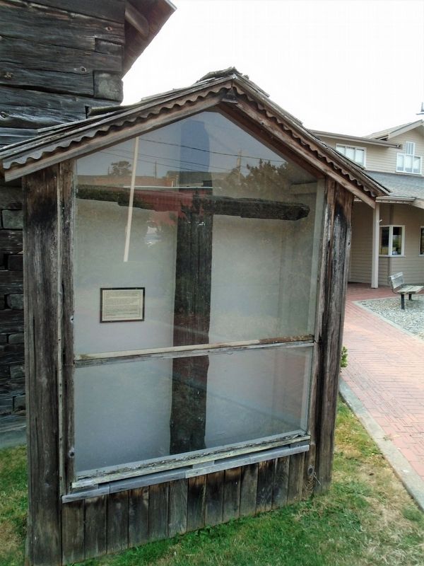
This Douglas Fir is about
700 years old. It would,
therefore, have been a
sapling about 200 years before
Columbus discovered America.
—————————————
Restored October 1986
This slab was found near Perrigo's Lake in the early 1930's . . . — — Map (db m179324) HM
You are standing in the nation's first historical reserve, a unique unit of the National Park Service.
The Reserve was originally championed by a group of concerned residents in the 1970s when Ebey's Prairie was subdivided for large-scale . . . — — Map (db m179320) HM
Ebey's Landing, the nation's first National Historical Reserve, was established by Congress in 1978 "in order to preserve a rural community which provides an unbroken historical record from nineteenth century exploration and settlement in Puget . . . — — Map (db m179349) HM
Places to visit
1 Island County Museum
908 NW Alexander Street
The Island County Museum features local and regional history. Ice Age relics, woolly mammoth remains, a Native American collection that includes . . . — — Map (db m179321) HM
A Glimpse In Time
Like the majority of the coastal forts built in the United States, Fort Casey never fired its guns in warfare.
Fort Casey is one of three coastal forts constructed in the late 1890s to defend the entrance to Puget Sound . . . — — Map (db m61063) HM
Penn Cove and Coupeville are home to the Schooner SUVA, during sailing season. See her moored at the historic wharf.
A FAMILY YACHT
In 1925, Frank J. Pratt Jr. had SUVA built in Hong Kong. Her old growth Burmese Teak hull and . . . — — Map (db m179319) HM
...came to Whidbey Island in 1895 as a young lawyer and stayed, having been struck with a life-long love of its beauty. Served as Island County Prosecuting Attorney 1896-1907, and Superior Court Judge for Clallam, Island, and Jefferson Counties . . . — — Map (db m179283) HM
History
The Alexander Block house is one of four blockhouses remaining in Central Whidbey Island. Few original blockhouses of this type remain throughout the United States. John Alexander, Sr. built this blockhouse on his donation land claim . . . — — Map (db m60986) HM
Left side of marker is written in Gaelic and right side is in English
Died here. April, 9 AD 1861
One year ten and twenty
(years) of age
Born at Mineth, Ireland
Gentle wife (of) Sam’l Maylor
They married in Liverpool
At the . . . — — Map (db m60979) HM
From the end of the Lake Ozette Road, 2 trails lead to the ocean beaches. One, the Indian Village Trail, leads to the site of an abandoned Ozette Indian village at Cape Alava. For over 2000 years, Cape Alava was home to the Makah Indians. . . . — — Map (db m179353) HM
Saved Blockhouse
In 1921 a local civic group, the Ladies of the Round Table (LORT) began a ten year effort to restore the decaying Davis Blockhouse. Local carpenter Fred Krueger handled the project carefully replacing rotting beams while . . . — — Map (db m60991) HM
Donation claim of Jacob Ebey.
Served in War of 1812, the Black Hawk War and the Mexican War.
When 61 yrs old led company across plains with covered wagons.
Settled on Whidbey Island and built this home, four blockhouses and stockade in 1856 . . . — — Map (db m60977) HM
Sudden Indian attacks at Seattle and Bellingham in 1855 caused consternation among the small pioneering settlements on Puget Sound. The tradition of blockhouse defense was well known to American settlers, dating from the earliest English colonies. . . . — — Map (db m61040) HM
Ferryboats have been active on Puget Sound since January 1, 1889. The City of Seattle offered the first scheduled service between Seattle and West Seattle; a bargain at 5 cents per passenger!
The Washington State Ferry System traces . . . — — Map (db m179348) HM
The Coupeville Wharf was built in 1905 in response to the increased economic, military and social activities in the area, and was one of several that supported the busy shipping commerce to and from Whidbey Island.
In the late 1800s, sailing . . . — — Map (db m179287) HM
Died in Service
Harvey Baker · Camano • Glenn E. Muzzall · San de Fuca
Ernest Knowles · Crescent Harbor • George B. Morris · Smith's Prairie
Math. L. English · Fort Casey • Harry Nourse · Maxwelton
Harry Burton · Langley • . . . — — Map (db m179280) WM
The cottage was actually built as two separate buildings. The eastern half was built as a law office for James Zylstra. The western half was added and the building became the medical office for Dr. Chas. White. In 1998 Rev. Barry Burton & Capt. Mike . . . — — Map (db m61037) HM
The swirling waters that pass in and out of the narrow channels between Whidbey Island and Fidalgo Island have captivated visitors to this area for thousands of years. Salish Native American tribes were the first human inhabitants of these . . . — — Map (db m74012) HM
It's hard to imagine Deception Pass without the bridge. But until 1935, the gap between Fidalgo Island and Whidbey Island could only be crossed by boat. In 1924 a small ferry called the Deception Pass began running between Yokeko Point . . . — — Map (db m74083) HM
When the federal government transferred 1,700 acres of land on Fidalgo Island and Whidbey Island to the State of Washington in 1925, Deception Pass State Park was barely an idea. For decades, the land had been a military reservation set aside . . . — — Map (db m74085) HM
Built by Richard Luhn
on the site of Anderson's
blacksmith shop. Housed his
realty and a dentist's office.
Robert Smith's "First Properties"
realty followed. Lawyer Tim Martin added an addition in
1982. Waterman Enterprises, Inc. bought the . . . — — Map (db m195450) HM
Built in 1939 on the site
of Langley's first hotel
that burned in 1921, it
served as the Post
Office until 1960.
It next housed a
laundry, pottery studio,
appliance repair shop, wine shop, antique store,
and flower shop, before becoming . . . — — Map (db m195443) HM
Joe Primavera founded
the Star Store in 1919
as a shoe repair
business in his home at
Second Street and
Anthes Ave. He
moved the business to
First Street in 1922.
Joe, wife Martina and son Victor are standing in
front of the new 1929 . . . — — Map (db m195446) HM
Frederick Tiemeyer ran a
bakery here from 1925 to
1944. His nickle
butterhorns were very
popular.
The building next housed
linoleum and furniture
stores, beauty and barber
shops, and several other
businesses before becoming the Cafe . . . — — Map (db m195445) HM
Dedicated to all U.S. Navy Patrol and Reconnaissance Naval Aviators, Naval Flight Officers and Aircrewmen who, for the cause of freedom, have made the ultimate sacrifice.
Special thanks to Mr. John Christiansen for his many contributions to . . . — — Map (db m74000) HM WM
Family Origins
This park is named after the family of Egbert and Betty Beeksma in recognition of the business they started on the site of park and their contribution to the development of Oak Harbor.
Egbert Beeksma was born the Netherlands . . . — — Map (db m60940) HM
Before the bridge was completed in 1935, the only way to cross Deception Pass was by boat.
If you wanted to take your car from Whidbey to Fidalgo Island in 1929 your crossing would look like this, aboard the MV Acorn.
Your captain could . . . — — Map (db m61465) HM
Named by Captain George Vancouver 10 June 1792. Feeling that he had been “Deceived” as to the nature of the inner waterway, Port Gardner (now Saratoga Passage) he wrote on his chart “Deception Pass”. He . . . — — Map (db m60904) HM
To the north of this narrow passage is Fidalgo Island, so named for the Spanish explorer, Lieutenant Salvador Fidalgo. To the south is Whidbey Island, second largest island in the contiguous 48 states, which Captain George Vancouver, while exploring . . . — — Map (db m60903) HM
This Navy flagstaff is placed here to honor all those Navy people who have served aboard the Naval Air Station on Whidbey Island, their families, and the people of Oak Harbor who have long supported the Navy mission.
Our National Ensign was . . . — — Map (db m73990) HM WM
Oak Harbor’s early “town” was built along the waterfront, and stretched from Maylor’s store along Pioneer Way to about a block east of the junction of Flintstone Freeway and Midway and Pioneer.
The east end of the town burned in a . . . — — Map (db m60938) HM
'Why do we love the sea? Because she has the power to make us think things we like to think.'
- Robert Henry
The Old Wharf and Steamships
Look offshore toward Maylor's Point and you will see a concrete block that remains from Oak . . . — — Map (db m73991) HM
The Skagit Indians maintained several villages on Penn Cove. The paramount Skagit chief lived at Snakelum Point, southeast across the cove. The village at Monroe’s Landing was called cokwol’a. Cokwol’a was a major village of the Skwdabs, a subgroup . . . — — Map (db m61074) HM
Just as the cabin tells a story of the site's history, so does nature. The large stumps in the area tell about early logging activity. Notice in the photo how different the cabin must have been with an expansive view before the new forest . . . — — Map (db m115751) HM
Emory Finch, the son of Hoodsport pioneers, moved into Interrorem with his new bride Maybelle Peterson on their wedding day, April 22. 1908. Like her husband, she saw at home in the outdoors. The couple met when she and two friends came over from . . . — — Map (db m116139) HM
Interrorem Ranger Cabin is the oldest Forest Service dwelling on the Olympic Penninsula and one of the oldest in the Northwest.
As you gaze through the trees at Interrorem Ranger cabin, step back in time to the Spring of 1907. From this spot . . . — — Map (db m116138) HM
The name Interrorem, according to the most popular theory, was derived from Latin meaning "between the gold". Others believe it was slang for "Interim," used by those who thought the cabin would be a temporary site for managing the forest. Instead, . . . — — Map (db m116137) HM
Early Forest Rangers were custodians of the forest, riding horseback over mountain trails and camping out, protecting the forest from fires, poachers, and trespassers.
Most were outdoorsmen, former cowboys, trappers and woodsmen. They were hired . . . — — Map (db m116140) HM
It is no wonder that the churning fishing hole one mile down this trail is called Ranger Hole. Emery Finch, and many other early Rangers were avid fishermen, wearing a well traveled path between the cabin and their favorite fishing spot. Fishing was . . . — — Map (db m116141) HM
Sv. Nikolai Mission In September 1808 the Russian American Company (RAC) schooner Sv. Nikolai (Saint Nicholas) set sail from the Russian American Company's fort in Sitka, which was then in Russian territory (now part of the State . . . — — Map (db m129574) HM
Anna Petrovna Anna Petrovna Bulygin, a Russian woman notable for being the first European woman known to live in what is now Washington State, landed with the crew of the Sv. Nikolai. Anna was eighteen years old, the attractive wife of . . . — — Map (db m129585) HM
Escape to the Hoh River Leads to Captivity At dawn following a harrowing, fearful night awaiting retribution, the Russian party reconnoiters, but finds only dense forest growing down to the high-tide surf line. Captain Bulygin decides to take . . . — — Map (db m129588) HM
The tribal name for the Hoh River is Chalak'At'sit (meaning "The Southern River"). The river itself is focal in Hoh tribal identity and folk-history and in traditional economic patterns. The Hoh people were created along the river. Mythic . . . — — Map (db m129587) HM
Thousands of winters before the arrival of the White Drifting-House people, the Ho-qwats, the Quileute Indians and the ghosts of their ancestors lived and hunted near La Push, Washington. For as long as the ageless memory of legend recalls, the . . . — — Map (db m129589) HM
To commemorate the exploration of the waters of the Pacific Northwest by Captain George Vancouver, R.N., whose first camp was on the beach at the mouth of this stream May 2, 1792. — — Map (db m312965) HM
To commemorate the exploration of the waters of the Pacific Northwest by Captain George Vancouver R.N. whose first camp was on the beach at the mouth of this stream May 2, 1792.
Erected 1929 by Michael Trebert Chapter Daughters of the . . . — — Map (db m313515) HM
The čičməhán Trail is comprised of 16 sites that naturally divide into a 3-mile, a 6-mile, or a 12-mile loop. The 3-mile loop includes downtown historical sites; the 6 mile loop extends uptown; and the 12-mile loop (best for . . . — — Map (db m179367) HM
For more than 50 years, the bell was used to call volunteer fire fighters to their posts. It is the only known tower of its kind in the United States. It was restored in 2003 by the Jefferson County Historical Society and the City of Port Townsend . . . — — Map (db m155268) HM
Early settlers to the Port Townsend area found a S'Klallam Indian community well established on the protected shores of Port Townsend Bay. This settlement, known as Kah Tai, meaning "to carry" or "pass through," was located on the portage route . . . — — Map (db m179612) HM
The S'Klallam people made their canoes from Western Red Cedar trees ranging from 300-800 years of age. Seats and brackets were made of Yew wood, and paddles carved from Yellow Cedar.
Canoes Came In All Sizes
A freight canoe of good . . . — — Map (db m179378) HM
Commemorating Capt. George Vancouver’s discovery, landing & naming of Port Townsend in honor of the Marquis of Townshend, May 7, 1792.
Donated Dec 1, 1986, by the DeLeo Family, residents of Port Townsend since 1883. — — Map (db m91334) HM
Tucked away in what was once a secluded corner, the cemetery was to be the final resting place for those soldiers and their immediate family members who died at Fort Worden. The first burial in the 360 plots was that of Pvt. Elisha Webb, in . . . — — Map (db m179754) HM
Chief of the Clallam Indians
A Friend of the White People
From this rock
he gave warning of danger
and saved them
from massacre in 1856 — — Map (db m179770) HM
Many in Port Townsend have heard of Chief Chetzemoka (Cheech-Ma-Ham), chief of the S'Klallam. At Point No Point in 1855, he signed the treaty giving up all S'Klallam land for a reservation to be shared with another tribe. Such treaties, pushed . . . — — Map (db m179408) HM
"Blessed are the peacemakers:
for they shall be called
the children of God." Matthew 5:9
"If I am seen coming to you I will not be able to help you further. But each morning I will sit on top of the big rock on the east side of Kai Tai . . . — — Map (db m179771) HM
What was the Chinese Exclusion Act of 1882?
Like many other cultural communities in early Port Townsend, Chinese and Chinese American merchants, families, farmers, and laborers were an important part of the cultural and economic . . . — — Map (db m179707) HM
Who was the "Crimper King" of Port Townsend?
The practice of forced maritime service was known as "crimping" in the 19th Century. Early fortunes were made provisioning out-bound ships with sailors. Maxwell Levy, the "Crimper King" of . . . — — Map (db m179358) HM
What did Port Townsend look like in the 1860s?
You are standing near the site of Port Townsend's first settler cabin. The area was often flooded with seawater. Alfred A. Plummer, age 29, arrived in 1851 with Charles Bachelder and . . . — — Map (db m179690) HM
This is the last remaining
wooden fire bell tower in the
United States.
Port Townsend’s Fire Bell Tower is a 75-foot wooden structure built in 1890 to hold a 1,500 pound brass bell and the city's new $900 fire engine.
. . . — — Map (db m83775) HM
How was early Port Townsend affected by fire?
Port Townsend's earliest buildings were tightly packed wooden structures, that were both lit and heated by fire. The threat of disastrous, multi-building fire was ever-present. Entire . . . — — Map (db m179736) HM
Port Townsend's first stone building was completed in 1874 for Enoch S. Fowler. It served as the Jefferson County Courthouse from 1880-1892 (and was also used as a store, performance hall, Masonic Temple, seamen's chapel, and, since 1916, home of . . . — — Map (db m179527) HM
The Haller Statue and Fountain was donated to the city by Theodore N. Haller "in memory of early pioneers."
After the dedication speech in 1906, Mr. Haller read a poem about the Greek sea nymph, Galatea, and the statue has been known . . . — — Map (db m179703) HM
Under the provisions of the
State Historic Preservation Act of 1967,
this property possesses particular value
in commemorating, or illustrating
American History
Placed on the State Register
Feb. 11, 1972 by the Governor's Advisory . . . — — Map (db m179516) HM
In 1891 architects Batwell & Patrick designed a multi-purpose civic structure to house administrative offices, council chamber, courtroom, fire hall and jail to serve the needs of a city of 20,000.
Port Townsend's city council still meets . . . — — Map (db m129357) HM
Founder of Admiralty Aububon
who led the effort to save
Protection Island as a
sanctuary for nesting seabirds
A gift from Audubon members & friends,
Eleanor's family, Friends of the Arts, and the
City of Port Townsend Public . . . — — Map (db m179412) HM
Chetzemoka's Big Heart, a story by Mary Ann Lambert (1879-1966, also the author of The 7 Brothers of the House of Ste-Tee-Thlum) of the Jamestown S'Klallam Tribe's Lambert/Reyes family, illustrates Chetzemoka's heart, and the power and respect he . . . — — Map (db m179745) HM
In 1989, the Canoe Culture was revitalized with the inception of the Intertribal Canoe Journey. The S'Klallam/Klallam Tribes participate in the Intertribal Canoe Journeys in which Canoe Families from dozens of Tribes travel to one destination . . . — — Map (db m179387) HM
For centuries, the S'Kallam people traded with other Tribes within the continental U.S. and across the Strait in Canada. Direct trade was the Native method of food and materials redistribution across geographical bounds, and from great . . . — — Map (db m179381) HM
Under the provisions of the National
Historic Preservation Act of
October 15, 1966, this property
possesses exceptional value in
commemorating, or illustrating
American history
Placed on the National Register on
July 24, 1973 by . . . — — Map (db m179757) HM
Dedicated May 21, 1948
as a lasting tribute
in honor of those from
Jefferson County
who sacrificed their lives
for their country
in the two World Wars
1917 • World War I • 1918
James A. Anderson · Fred W. Anderson · John W. . . . — — Map (db m179733) WM
Here in the wind-buffeted rain shadow of the Olympic Mountains grow colorful relics of the last ice age. The tiny prairie before you is a remnant of once extensive grasslands that followed the retreat of continental ice over 10,000 years ago. . . . — — Map (db m179767) HM
Dedicated to all the men and women
of Jefferson County who served in
the Korean War
and most especially to
those who made the supreme sacrifice
Herman Felhoelter Capt U.S. Army KIA 16 July 1950
Donald A. Bare Cpl U.S. Army KIA 01 . . . — — Map (db m179752) WM
Begun in 1892 by Port Townsend pioneer Joseph A. Kuhn, this building represented the latest ideas of the time in architecture. Construction was directed by Jonas Guise, then the best known contractor in the area. Bricks came from the yards of . . . — — Map (db m91331) HM
Marvin Shields was a product of the Northwest. He graduated from Port Townsend High School and then went to work in Alaska for the Mineral Basin Mining Company. He enlisted in the Navy in 1962 and joined Naval Mobile Construction Battalion 11. . . . — — Map (db m179361) HM WM
Courage and Patriotism above and beyond the Call of Duty
Honoring Marvin Glenn Shields, CMA3, U.S.
Congressional Medal of Honor
Dong Xoai, Vietnam
June 9, 1965
Dedicated by Daughters of the American Revolution — — Map (db m312968) WM
The Jamestown S'Klallam Tribe, like the Northwest Maritime Center, is a 21st century organization with a tremendous appreciation of our seafaring history and respect for those who have preserved and shared their knowledge throughout the . . . — — Map (db m179410) HM
For over 8,000 years Native Americans camped at Point Hudson while migrating from summer camps to winter lodges.
The American explorer, Captain Charles Wilkes, named the area in honor of Commander William L. Hudson in 1841. . . . — — Map (db m179370) HM
Before the shoreline was filled to create the marina, Point Hudson was a popular clamming beach for S'Klallams and a landing point for tribes from locations across the Olympic Peninsula.
Change began as soon as settlers arrived, but grew . . . — — Map (db m179751) HM
It is believed that for thousands of years Point Hudson was used as a seasonal home by the Native American tribes, particularly Klallam and Chemakum. Presence of a freshwater lagoon, a wide variety of shellfish and other seafood easily obtained . . . — — Map (db m179746) HM
This point of land is formed of rocks and sand constantly in motion carried here by wind and waves. These sediments, eroding from nearby glacial bluffs, converge here from the northwest and the south before moving along the spit into deeper . . . — — Map (db m179749) HM
Activated on 15 Dec. 1879, the original light was located atop the lightkeepers house. It was moved to its present position when this structure was built in 1913. The lighthouse has been closed to the public since its automation in Nov. 1976. . . . — — Map (db m197213) HM
Under the provisions of the National Historic Preservation Act of October 15, 1966, this property possesses exceptional value in commemorating, or illustrating American history Placed on the National Register on Sept. 29, 1970 — — Map (db m222603) HM
Hidden Histories
Port Townsend's architectural history is so well preserved, it's easy to overlook the stories that remain hidden. Our city, community, and daily lives are defined by what came before. Today's Port Townsend is in . . . — — Map (db m179704) HM
[(Top plaque)] Under the provisions of the National
Historic Preservation Act of
October 15, 1966, this property
possesses exceptional value in
commemorating, or illustrating
American history.
Placed on the National Register on . . . — — Map (db m197156) HM
In the early 1890s, Port Townsend expected to be the major seaport for the northwest coast, and built to serve a huge population that never came. By 1896, the economic tide reserved, and the town was left high and dry. A century later, historic . . . — — Map (db m179624) HM
Why are there so many Victorian buildings here?
Many of the historical buildings around you were built in the 1880s and 1890s. The facades of these ornate stone, brick, and cast iron structures memorialize the names of their . . . — — Map (db m179442) HM
This site is the last remaining vestige of the natural prairie that spanned the qatáy Valley, between wetland areas. Relatively dry, upland areas of the valley provided camas bulbs (qʷɬúʔi in Klallam and Camassia quamash in Latin) . . . — — Map (db m179762) HM
Did Port Townsend have a railroad?
1880s Port Townsend was a booming seaport and Washington's Port of Entry. Great efforts were made to connect the city with the nation's expanding railway systems. Local business owners and . . . — — Map (db m179536) HM
Under the provisions of the National
Historic Preservation Act of
October 15, 1966, this property
possesses exceptional value in
commemorating, or illustrating
American history
Placed on the National Register on
Sept 29, 1974 by . . . — — Map (db m177418) HM
Port Townsend's strategic location at the entrance to Puget Sound won it the U.S. Customs Service headquarters in 1854, just three years after the town was established.
Every vessel entering Puget Sound from any foreign port was . . . — — Map (db m179374) HM
1519 entries matched your criteria. Entries 301 through 400 are listed above. ⊲ Previous 100 — Next 100 ⊳