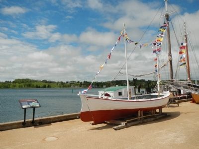
On Bluenose Drive close to King Street, on the right when traveling west.
The Labrador whaler Anderson Bros. is the type of boat that was used extensively in the Labrador fishery of the 19th century. Lunenburg County had a large fleet of 40 to 60 ton schooners known as “Labradormen” that went to the . . . — — Map (db m78205) HM
On Blockhouse Hill Road at Townsend Street, on the left when traveling north on Blockhouse Hill Road.
English
During the American Revolution many coastal settlements were harassed by enemy privateers. On the morning of 1 July 1782 approximately 100 raiders surprised and overpowered Lunenburg’s small defence force, captured the blockhouses . . . — — Map (db m78317) HM
On Cornwallis Street at Fox Street, on the left when traveling north on Cornwallis Street.
Lunenburg is home to the oldest worshiping Lutheran congregation in Canada. The first Lutherans, mostly Germans from farming districts of the Upper Rhine, settled in the Town in 1753. Initially they worshiped outdoors and later were allowed to . . . — — Map (db m112480) HM
On Main Street (Nova Scotia Route 3) at Edgewater Street ( Route 3), in the median on Main Street.
This stone of remembrance
is erected in loving memory
of our brave men
who laid down their lives
in the Great War
1914 - 1918
for
Truth Justice Liberty
In honour
of all who served
and in grateful appreciation
of the valiant . . . — — Map (db m112530) WM
On George Street (Nova Scotia Route 289) just west of North Provost Street ( Route 348), on the right when traveling west.
Born in Pictou, here he was raised and lived his adult years.
Educated in the New Glasgow Schools, Sackville (Mount Allison) Academy, Glasgow University Scotland.
Public Servant, Politician, Pharmacist, Sportsman, Farmer, Horse Breeder. . . . — — Map (db m144796) HM
Near Glasgow Street at Dalhousie Street, on the left when traveling north.
Into the East River at New Glasgow between 1821 and 1918 were launched some two hundred and ten sailing ships of 100 to 1400 tons burthen, built by native workmen from native materials.
The locally owned, commanded and manned vessels moved . . . — — Map (db m144793) HM
On North Provost Street (Nova Scotia Route 348) at George Street ( Route 289), on the right when traveling south on North Provost Street.
This area of Downtown New Glasgow was known as Bell's Corner for well over a century. Basil Bell (chemist, teacher and entrepreneur) constructed this architecturally sound stone home and store (to your left) in the mid 1840's. He and his wife . . . — — Map (db m144797) HM
On Glasgow Street just south of Dalhousie Street, on the right when traveling north.
”One of New Glasgow’s most interesting and notable persons is George Rogers McKenzie. During his lifetime he was a builder of ships, deep water captain, a master mariner and a politician.” —Stories from Pictou County’s Past, Clyde F. . . . — — Map (db m144795) HM
Near George Street (Nova Scotia Route 4) (Nova Scotia Route 289) just east of Terrace Street, on the left when traveling east.
The land upon which this park is situated was given to the Town of New Glasgow by James William Carmichael, Esq. on the Twenty-fourth day of November Eighteen Hundred and Ninety — — Map (db m144802) HM
On Provost Street (Route 4) at Dalhousie Street, on the right when traveling south on Provost Street.
English:
Born and educated in New Glasgow, Cameron, having graduated from the Boston Law School, practiced law in the United States before joining Queen’s University in 1882. The following year he became editor of the Kingston . . . — — Map (db m139298) HM
Near Archimedes Street (Nova Scotia Route 4) (Nova Scotia Route 289) just north of Dalhousie Street, on the right when traveling north.
This parcel of land in New Glasgow, Nova Scotia deeded to the City of Glasgow, Scotland, Aug. 6, 1975, during the visit of the Honourable Peter T. McCann, Lord Provost of the City of Glasgow, to officiate at the Festival of Tartans on the occasion . . . — — Map (db m144804) HM
On Archimedes Street (Nova Scotia Route 4) (Nova Scotia Route 289) north of MacLean Street, on the left when traveling north.
You are standing beside the Mae MacGillivray Building, which was renovated in 2014 by MacGillivray Properties Limited. The loft apartments have an industrial theme rooted in the County's history of coal, steel and shipbuilding. A 1916 book Pictou . . . — — Map (db m144806) HM
Near George Street (Nova Scotia Route 4) (Nova Scotia Route 289) just east of Terrace Street, on the left when traveling east.
This memorial and activity trail recognizes the inspiration of Johnny C. Miles (1905 to 2003). Johnny grew up in Sydney Mines, Nova Scotia and became an internationally known sports figure following his 1926 and 1929 wins of the Boston Marathon. He . . . — — Map (db m144803) HM
Near Dalhousie Street just east of Temperance Street, on the right when traveling east.
Originally dedicated in 1898 in honour of F.D. Laurie, former Mayor of New Glasgow, this park was rededicated in 1992 as Laurie Park, a Peace Park, by Her Worship Mayor Ann MacLean, on behalf of the residents of the Town of New Glasgow and the . . . — — Map (db m144883) HM
On Glasgow Street just south of Dalhousie Street, on the right when traveling north.
The community that was to become New Glasgow was settled in 1784 by Deacon Thomas Fraser. By 1809 the Town was named after Old Glasgow in Scotland and incorporated in 1875. A strong entrepreneurial spirit was evident even in 1809 when the first . . . — — Map (db m144794) HM
On Archimedes Street (Nova Scotia Route 4) (Nova Scotia Route 289) at Dalhousie Street, on the left when traveling north on Archimedes Street (Nova Scotia Route 4).
New Glasgow is a scenic riverside town of 9,455 residents, which serves as the commercial-service centre for northern Nova Scotia with a rich multi-cultural mosaic. Founded by Scottish settlers in 1784, the town was named after Glasgow, Scotland . . . — — Map (db m144801) HM
On Archimedes Street (Nova Scotia Route 4) (Nova Scotia Route 289) just south of Dalhousie Street, on the right when traveling north.
This bell, belonging to the Town of New Glasgow, was refurbished and a bell tower was constructed as part of the New Glasgow Downtown Revitalization Project - Recreating the Experience, in 2009.
The bell was originally manufactured and supplied . . . — — Map (db m144799) HM
Near Terrace Street north of George Street (Nova Scotia Route 4) ( Route 289), on the right when traveling north.
Donated to the citizens of the Town of New Glasgow in memory of our fallen comrades Normandy Br 34 The Royal Canadian Legion October 5 • 1980 — — Map (db m144880) WM
On MacLean Street just east of James Street, on the left when traveling east.
In grateful memory of The Rev James Drummond MacGregor, D.D. Born at Comrie, Perthshire, Scotland, 1759. Died at East River, Pictou, 1830. Pioneer Minister of the Gospel in Eastern Nova Scotia, where he labored with Apostolic zeal for 43 years. . . . — — Map (db m144800) HM
Near Temperance Street 0.1 kilometers north of Dalhousie Street, on the right when traveling north.
This likeness of a lion was sculpted by John A. Wilson in 1891 at the age of 15. Two others of its kind are known to exist, one here at the Carmichael Stewart House Museum and the other at the Lionstone Inn, Pictou.
This particular statue was . . . — — Map (db m144805) HM
Near Temperance Street 0.1 kilometers north of Dalhousie Street, on the right when traveling north.
This likeness of a lion was sculpted by John A. Wilson in 1902 at the age 26. Two others of its kind are known to exist, one here at the Carmichael Stewart House Museum and the other at the Lionstone Inn, Pictou.
Wilson, a New Glasgow native, was . . . — — Map (db m144807) HM
On Terrace Street north of George Street (Route 4), on the right when traveling north.
was in August 1784 with the arrival from Kirkhill, Inverness-shire, Scotland, of Thomas Fraser (Deacon) 1749 — 1813 who took possession of this land and created from the forest a farm home, the first in that part of the East River Lower . . . — — Map (db m139297) HM
On Stellarton Road (Nova Scotia Route 374) 1 kilometer south of Duff Street, on the left when traveling south.
The First Church in East Pictou was built on this site in 1787. Made of logs, it served the Lower Settlement East River Presbyterian Congregation for 16 years until 1803. From this beginning other Congregations developed in the East Pictou rural and . . . — — Map (db m144791) HM
On Archimedes Street (Nova Scotia Route 4) (Nova Scotia Route 289) just north of Dalhousie Street, on the right when traveling north.
Mrs. Viola Irene (Davis) Desmond was born on July 6, 1914 in Halifax, Nova Scotia, to James and Gwendolyn Davis. Viola was one of 15 siblings who grew up in and around the city area. After graduating from Bloomfield High School with excellent . . . — — Map (db m144798) HM
On West Branch Road 0.1 kilometers south of Sunrise Trail ( Route 6), on the left when traveling south.
Noted strongman of River John who amazed and astounded residents of River John, Pictou County and beyond with incredible feats of strength. Buried in Forest Hill Cemetery Denmark, N.S. — — Map (db m150300) HM
Near South Foord Street (Nova Scotia Route 374) at Union Street, on the left when traveling north.
”The Town of Stellarton always meant a lot to me” —Frank H. Sobey Stellarton Town Square was the site of the Jubilee Theatre and the first Sobeys Food Store, built in 1912 by John William Sobey to expand his meat delivery . . . — — Map (db m151321) HM
Near South Foord Street (Nova Scotia Route 374) at Union Street, on the left when traveling north.
Best known as the entrepreneur who grew his father’s small meat delivery business into a regional grocery powerhouse that has since expanded to serve millions of Canadians country-wide, Frank H. Sobey was, first and foremost, a proud Nova Scotian . . . — — Map (db m151320) HM
Near North Foord Street (Nova Scotia Route 374) 0.2 kilometers south of Trans-Canada Highway (National Route 104), on the left when traveling south.
English:
This British firm established coal mining as a major industry in Nova Scotia. Granted a monopoly of provincial mineral rights in 1826, the GMA developed coal operations here at Albion Mines and at Sydney Mines, and . . . — — Map (db m140077) HM
Near South Foord Street (Nova Scotia Route 374) at Union Street, on the left when traveling north.
"It was his friendliness, his knowing everybody in the community. It didn't matter whether you were a miner or a farmer or anyone else. He would stop and talk, ask your opinion about things, exchange notes about fishing." —Alfred MacDonald, . . . — — Map (db m151322) HM
On Main Street (Route 348) at Forge Street, on the left when traveling north on Main Street.
From humble beginnings, two enterprising Pictou County blacksmiths, Graham Fraser and Forrest MacKay would set up a business to manufacture products for the railway and shipping industry. In the year 1878 they would move their growing company to . . . — — Map (db m150404) HM
On Main Street (Nova Scotia Route 348) at Pleasant Street, on the left when traveling north on Main Street.
This interpretive panel erected on July 11, 2019 to commemorate the designation by Trenton Town Council of this area as a Trenton Heritage Site, where the first successful commercial pouring of Steel in Canada occurred in 1883, within the Steel . . . — — Map (db m150403) HM
On Main Street (Nova Scotia Route 348) at Forge Street, on the right when traveling north on Main Street.
On September first, 1953, seventy years after the production in the open hearth plant of the Nova Scotia Steel Company Limited at Trenton, Pictou County, Nova Scotia, of the first steel ever made in Canada, this ingot, cast in 1883, erected by the . . . — — Map (db m150496) HM
On Main Street (Nova Scotia Route 348) at Pleasant Street, on the left when traveling north on Main Street.
Trenton Works axle hammer had a distinct sound when operating. People would refer to it as the "heartbeat of Pictou County", as the sound meant the plant received an order which was good news for the local economy. Trenton Works employees were noted . . . — — Map (db m150402) HM
On Main Street (Nova Scotia Route 3) just east of Legion Street, on the right when traveling east. Reported missing.
In memory of the crew of the
Beam Trawler Jutland
foundered at sea March 11, 1920
These crossed anchors recovered from
fishing banks on Jutland's previous trip
are placed as a symbol of our hope that
their souls are resting in . . . — — Map (db m112407) HM
On Main Street (Nova Scotia Route 3) at Gorham Street, on the right when traveling east on Main Street.
Designed by Halifax architect Herbert E. Gates, this dignitied town hall was constructed in 1901-1902. Such buildings were central to civic life across the country, providing accommodation for the growing number of services administered by local . . . — — Map (db m112404) HM
The tradition of marking a burial grew out of people's inability to accept the finality of death. Since stone, by the human timescale, is not subject to decay, it represented something eternal.
The old burying grounds is one of Nova Scotia's . . . — — Map (db m112406) HM
On Main Street (Nova Scotia Route 3), on the right when traveling east.
Step Back in Time
Step back to the beginning of the seventeenth century. The Mi'Kmaq had given Liverpool the name 'Ogomkegea', meaning "place of departure." Descending the Mersey River in the spring they would disperse along the coast . . . — — Map (db m112387) HM
On Main Street (Nova Scotia Route 3) at Gorham Street, on the right when traveling east on Main Street.
Erected by the
Citizens
of
Queens County
to the Glory of God
and in loving memory
of
their sons who made the
supreme sacrifice
in the World War
1914 [World War I Honored Dead] 1918
1939 [World War II Honored Dead] 1945
1950 . . . — — Map (db m112398) WM
On Grenville Street (Nova Scotia Route 4) at Pepperell Street, on the right when traveling east on Grenville Street.
“at the going down of the sun and in the morning we will remember them.” To The Fallen World Wars 1914-18 1939-45 and Korean War — — Map (db m151583) WM
On Toulouse Street, on the right when traveling north.
English
St. Peter’s is one of Nova Scotia’s oldest settlements. The Portuguese were likely here in the 1500s, calling it San Pedro.
In 1650, the French established a post nearby under the name of Saint-Pierre, where they traded with the . . . — — Map (db m78728) HM
On Toulouse Street, on the right when traveling north.
English
The community of St. Peter’s is situated on the neck of land that separates the Bras d’Or Lake from the Atlantic Ocean. Up until the introduction of road and rail travel, the lake was the highway of the interior of Cape Breton and . . . — — Map (db m78729) HM
On Toulouse Street, on the left when traveling south.
There are two plaques on this monument
St. Peter’s Canal / Le Canal Saint-Pierre
English
Connecting St. Peter’s Bay on the Atlantic Ocean with the Bras d’Or Lakes, St. Peter’s Canal follows substantially the portage of the . . . — — Map (db m78726) HM
On Toulouse Street, on the right when traveling east.
English
Nicolas Denys, a merchant from Tours, France, arrived here in 1650 to restore an abandoned Portuguese fort called San Pedro. He renamed it Saint-Pierre, and set out to pursue fishing and trading - primarily in furs. Fort . . . — — Map (db m78727) HM
On Grenville Street (Nova Scotia Route 4) west of Pepperell Street, on the right when traveling west.
English: St. Peter's native son Wallace MacAskill (1887-1956) built an international reputation for his magical marine photography, but his fascination with the sea — and the ships and people who sailed on it — went far . . . — — Map (db m151582) HM
Alexander Graham Bell,
Teacher of the deaf
Humanitarian and inventor,
Became the first member of
The Telephone Pioneers of America,
On November, 2, 1911.
The Telephone Pioneers of America,
Are proud to dedicate this cairn
To . . . — — Map (db m79993) HM
Near Chebucto Street (Nova Scotia Route 205), on the right when traveling west.
English:
The Park commemorates the humanitarian and scientific achievements of Alexander Graham Bell (1847-1922) and his associates
Frederick W. Baldwin • John A.D. McCurdy • Glenn H. Curtiss • Thomas E. Selfridge
Most . . . — — Map (db m80007) HM
Near Chebucto Street (Nova Scotia Route 205) 0.2 kilometers east of Jones Street, on the left when traveling east.
English:
In the summer and fall of 1918, the valiant Canadian Corps, 100,000 strong, spearheaded a series of costly allied victories, now known as "Canada's Hundred Days" that led to the Armistice. During the First World War, more . . . — — Map (db m139694) HM
On Chebucto Street (Nova Scotia Route 205) close to Prince Street.
Commemorating The work of the Aerial Experiment Association which resulted in the first aeroplane flight within the British Empire made by J.A.D. McCurdy at Baddeck, Nova Scotia, on February 23, 1909. The Aerial Experiment Association was founded . . . — — Map (db m79992) HM
Near Chebucto Street (Nova Scotia Route 205) 0.2 kilometers east of Jones Street, on the left when traveling east.
English:In honor of the Aerial Experiment Association consisting of
Alexander Graham Bell
F. W. Baldwin
Glenn H. Curtiss
J. A. D. McCurdy
Thomas E. Selfridge
and of the Silver Dart which they
designed and built . . . — — Map (db m139879) HM
On Water Street close to Margaret Street, on the right when traveling north.
English: Derived from the Mi’kmaq name, ‘Abadak’, meaning “place with island near”, Baddeck’s first European settler was British officier James Duffus in 1819. He made his home on the “island near” and it was known . . . — — Map (db m80077) HM
On Shore Road (Nova Scotia Route 205) close to Twining Street, on the left when traveling west.
Commemorating
the founding of the
Home and School
Movement in Canada
December 18th, 1895
The
Parents Association
of Baddeck
held its first meeting on this, the site of the Baddeck academy.
The idea of such an . . . — — Map (db m79999) HM
Near Chebucto Street (Nova Scotia Route 205), on the right when traveling west.
English:
On February 23, 1909, more than 100 people witnessed the first successful powered flight in Canada, as the Silver Dart lifted off the ice of Baddeck Bay and flew 800 metres. The biplane, piloted by J. A. D. McCurdy, reached a . . . — — Map (db m79990) HM
On Chebucto Street (Nova Scotia Route 205) close to Queen Street, on the left when traveling west.
William Kidston arrived in Baddeck in 1835. It is believed he was sent from Halifax by the executors of the estate of the late James Duffus in order to settle up his business affairs. Young Mr. Kidston, it is said, fell “madly in love” with the . . . — — Map (db m80006) HM
Near Chebucto Street (Nova Scotia Route 205) 0.2 kilometers east of Jones Street, on the left when traveling east.
English: Women in Canada and Newfoundland were profoundly affected by the First World War. Overseas, they served as paid nurses and volunteers. On the home front, they laboured in factories, worked the land, ran patriotic . . . — — Map (db m139699) HM
On Nova Scotia Route 312, on the right when traveling south.
English:
Bird Islands is actually made up of two individual islands - Hertford and Ciboux. Home to an ancient Mi’kimaq legend, the great deity, Ktchi’scam, molded prophet Glooscap out of the earth ad breathed life into him with a . . . — — Map (db m151126) HM
On Nova Scotia Route 312, on the right when traveling south.
English:
Settled, 1629, by Captain Charles Daniel, and site of an early Jesuit Mission. Selected, 1713, as a naval base and one of the principal places in Isle Royale, named Port Dauphin and strongly fortified. Its importance declined with . . . — — Map (db m80005) HM
On Cabot Trail, on the right when traveling south.
1st War - Veterans - 2nd War
Killed in Action 1914 - 1918
Thompson Brewer
George Donavan
Charles MacDonald
Killed in Action
1939 - 1945
Murdoch J. Ross
Joseph Doucette
Daniel Smith
Bert Nicks
An additional 83 veterans . . . — — Map (db m139871) WM
On Lighthouse Road just east of New Haven Road, on the right when traveling east.
English:
With its close proximity to abundant fishing grounds, sheltered cove and excellent fish-drying conditions, Neil's Harbour was a popular fishing base for both French and Scottish settlers in the 1700's.
Neil MacLennan, . . . — — Map (db m139870) HM
Near Cabot Trail close to Mackillop Road, on the left when traveling south.
English:
As clergyman, schoolmaster and magistrate, he moulded the character of this community for a generation. Born at Stoer Point, Assynt, Scotland, he emigrated to Pictou in 1817, led his band of Scots to St. Ann in 1820 and remained . . . — — Map (db m80004) HM
On Cabot Trail at South Ridge Road, on the right when traveling south on Cabot Trail.
In grateful memory of
the men who gave
their lives
in two World Wars
1939-1945
E.J. Cameron
D.C. MacDonald
T. J. MacDonald
R. N. MacInnes
H. J. MacLennan
C. MacLennan
E. MacLennan
N. MacLennan
J. A. MacNeil
1914-1918
M. . . . — — Map (db m139337) WM
Fishing has been the backbone of Yarmouth's culture and economy for over 200 years. In the early days, salted dried cod was shipped by schooners and barques headed to the West Indies in exchange for rum, molasses and sugar. Today Yarmouth's . . . — — Map (db m107349) HM
The Southwestern shore of Nova Scotia, including Yarmouth County, is home to one of Canada's largest fisheries. For over two hundred years, fishing boats have sailed past this point, as well as from other ports in this region, to fish groundfish, . . . — — Map (db m107638) HM
An enduring symbol of Yarmouth's historic and economic ties to the sea, a lighthouse has towered over the rocky headlands of Cape Forchu since 1839, guiding mariners to the safety of Yarmouth Harbour. The current lighthouse was automated in . . . — — Map (db m107293) HM
Cheboque
The name "Cheboque" comes from the Mi'kmaw word for "big marshes", a very accurate name for this area. Beginning at Arcadia, the Cheboque salt marsh sprawls 343 hectares (837 acres) alongside the Cheboque River.
According to a 1607 . . . — — Map (db m107735) HM
The amazing geological formations you see along the Leif Ericson Trail, and at Cape Forchu, are the result of ancient volcanoes that erupted approximately 444-429 million years ago during the Silurian and early Devonian periods in Earth's . . . — — Map (db m107540) HM
Harbour of Deception
For almost two centuries, Yarmouth's False Harbour has lived up to its name. Located at the end of Cape Forchu, False Harbour's rocky shores have fooled the most experienced and capable of mariners, especially during . . . — — Map (db m107719) HM
The Town of Yarmouth, and its surrounding area, was settled in 1761 by Planters from Massachusetts. These settlers fished along the coast and harvested lumber from the forests to build homes, businesses and sailing vessels. By the . . . — — Map (db m107298) HM
The year 1879 was a disastrous one for Yarmouth County, Nova Scotia, with no fewer than 31 vessels lost along with 106 persons. The ships lost were among the best of the Yarmouth fleet, some carrying valuable cargoes. The loss of life left 26 . . . — — Map (db m107392) HM
Balise canadienne
Lorsque Samuel de Champlain visita la région en 1604, il la nomma Cap-Fourchu. Un an plus tard, Champlain s'installa à Port-Royal ou, La Cadie, un nom dérivé du nom « L'Arcadie » qu'un explorateur italien aviat donné à la . . . — — Map (db m107359) HM
Pieces of the Past
Since 1840, a lighthouse has kept watch over Cape Forchu and the approaches of Yarmouth Harbour.
In 1962, the original lighthouse was replaced with the iconic "apple core" structure that towers over the Cape today.
The . . . — — Map (db m107551) HM
Watching the waves crashing around Cape Forchu provides a small glimpse of the awesome and terrifying power of the sea. It continually shapes the lives of those who live and work by it. A source of beauty, bounty and economic prosperity, the . . . — — Map (db m107284) HM
The Tusket Islands
Located south of Yarmouth, the Tusket Islands extend mainly along the coast, from Pinkney's Point to Wedgeport. The Tusket Island chain was once a great asset to the fishing economy of Nova Scotia's Southwestern . . . — — Map (db m107652) HM
A Yarmouth - Viking Connection?
This scenic trail is named after the famous Norse explorer, and son of Eric the Red, Leif Ericson, who may have visited these shores sometime around 1000 AD.
Many scholars regard Leif Ericson as the first . . . — — Map (db m107487) HM
On Nova Scotia Route 308 at Chemin des Gasson, on the right when traveling south on Nova Scotia Route 308.
Jusaqu'aux années 1950 on pouvait encore voir plus de 1000 barges ou meules de foin entre la Pointe-du-Sault et la Pointe-des-Hubbard, surtout dans la région appelée « Passe de pré ». Des hommes habiles à la faux pouvaient faucher environ . . . — — Map (db m108766) HM
Le Village presents the lifestyle, culture and traditions of the Acadians of Nova Scotia at the turn of the 20th century, approximately 250 years after they first settled in the Pubnico area. This is the longest established Acadian region . . . — — Map (db m108266) HM
Before You Step Back in Time...
Though Le Village historique acadien is a created outdoor museum, it speaks to truths about the overall Acadian experience in Nova Scotia, and to the particular life and times of the Pubnicos in the . . . — — Map (db m108272) HM
On Old Church Road 0.7 kilometers east of Route 335, on the left when traveling east.
Les pionniers acadiens
Pubnico est le plus ancien village acadien encore habité par les descendants des familles fondatrices. Vous trouverez, dans l'annuaire téléphonique, près de 400 personnes du nom d'Entremont. Ils sont les descendants . . . — — Map (db m107971) HM
On Dennis Point Road 1 kilometer south of D'Entremont Road, on the left when traveling south.
Récolter la mer
Vous êtes debout sur l'un des quais de pêche les plus achalandés au Canada.
Autrefois, le hareng était pêché dans des parcs en fascines, ou « nijagans » inventés par les Mi'kmaq. Le poisson entrait dans le parc . . . — — Map (db m108006) HM
On Old Church Road 0.7 kilometers east of Route 335, on the left when traveling east.
Foundateur de la
Baronnie de Pobomcoup
(Pubnico) 1653
Founder of the
Barony of Pobomcoup
(Pubnico) 1653
Don du reveil de Pombcoup
Sculpteur - Albert Deveau - Sculptor
Aout - 1998 - August
Remplace - Replaced
Sculpteur - James . . . — — Map (db m107967) HM
There is not now and never has been a single definition of Acadie, or Acadia. It all depends on the time period and one's point of view.
Back in the 1600s and early 1700s, Acadie was a loosely defined region that more or less . . . — — Map (db m108271) HM
Acadians themselves can best answer this question, and our staff looks forward to sharing stories and insights into Acadian history and culture. We are also pleased to share some information on this panel for your reading pleasure.
As Acadie was . . . — — Map (db m108270) HM
On Dennis Point Road 1 kilometer south of D'Entremont Road, on the left when traveling south.
Following the fish
While Dennis Point's most valuable fishery is lobster, this wharf is also home to Canada's largest ground fishing fleet. This diverse fishery takes our fishermen (and women) to many special fishing areas.
Going the . . . — — Map (db m108001) HM
Near Rocco Point Road 1.2 kilometers south of the Lighthouse Route ( Route 3).
La chapelle originale fut construite sur le site en 1784. La vue sur la colline est superbe. Vous pouvez facilement imaginer l'arrivée des fidèles à la messe à pied, à cheval, par bateau, ou par attelage de bœufs.
Après son arrivée de France en . . . — — Map (db m108627) HM
Near Rocco Point Road 1.2 kilometers south of the Lighthouse Route ( Route 3).
Le Site
La Pointe-à-Rocco fut fondée en 1767 par les Acadiens revenus de l'exil. Pierre LeBlanc, Pierre et Louis Muis et Pierre Surette furent les premiers à s'établir dans le village. Ce site était le lieu de la première chapelle. . . . — — Map (db m108641) HM
Near Rocco Point Road 1.2 kilometers south of the Lighthouse Route ( Route 3).
Avant la construction des églises, les enterrements avaient lieu près de la mer du côté d'Eel Brook. C'est dans cet endroit d'inhumation que seraient enterrés Catherine Bro et Pierre Suret II, le couple fondateur de la région.
Catherine Bro, de . . . — — Map (db m108637) HM
On the Lighthouse Route (Nova Scotia Route 3) at Rocco Point Road, on the left when traveling west on the Lighthouse Route.
Une chapelle fut construite à la Pointe-à-Rocco en 1784. Elle fut utilisée par des Acadiens et des Mi'kmaq de la région jusqu'à ce qu'une église plus grande soit construite sur le site en 1808. À la suite d'un incendie dévastateur en 1900, . . . — — Map (db m108513) HM
On the Lighthouse Route (Nova Scotia Route 3) at Rocco Point Road, on the right when traveling west on the Lighthouse Route.
1914 - 1918
[Died in Service]
Anthony Doucette • Felix Doucette
Simon Doucette
[Honor Roll of Veterans]
1939 - 1945
[Died in Service]
Louis Babin • William Doucet
Walter Deveau
[Honor Roll of Veterans]
Parishioners who . . . — — Map (db m108613) WM
On the Lighthouse Route (Nova Scotia Route 3) at Courthouse Road, on the right when traveling north on the Lighthouse Route.
This well-preserved building, constructed between 1802 and 1805, is the oldest-known combined court house and jail still remaining in Canada. A prominent symbol of law and order, this building type was common to British North American towns in the . . . — — Map (db m108770) HM
On the Lighthouse Route (Nova Scotia Route 3) at Courthouse Road, on the right when traveling north on the Lighthouse Route.
Nova Scotia was the first colony in British North America to receive English law in all its jurisdictional variants, and the first colony to establish the legislative institutions necessary for the enactment of law. It was the first to evolve . . . — — Map (db m108771) HM
On the Lighthouse Route (Nova Scotia Route 3), on the right when traveling north.
The year 1879 was a disastrous one for Yarmouth County, Nova Scotia, with no fewer than 31 vessels lost along with 106 persons. The ships lost were among the best of the Yarmouth fleet, some carrying valuable cargoes. The loss of life left 26 . . . — — Map (db m112154) HM
On Courthouse Road just east of the Lighthouse Route ( Route 3), on the right when traveling east.
Le plus ancient tribunal
Le premier gouvernement local de la région du comté actuel de Yarmouth fut institué en 1789 par l’établissement du Tribunal des Sessions générales de la paix qui servait les districts de Yarmouth et d’Argyle. Il . . . — — Map (db m112162) HM
On the Lighthouse Route (Nova Scotia Route 3) at Courthouse Road, on the right when traveling north on the Lighthouse Route.
Next to the Court House on the east side of the street was the Tusket Cycle Company and just south of that, the Methodist Church built in 1877. On the opposite side of the street, the building in the foreground with the bundle of . . . — — Map (db m108772) HM
On the Lighthouse Route (Nova Scotia Route 3) at Route 308, on the right when traveling north on the Lighthouse Route.
GIIIR
In proud memory
of those
United Empire Loyalists
the majority
of them of Dutch origin
who
defeated and despoiled
were compelled to find
refuge here following the
American Revolution.
Arriving here, . . . — — Map (db m108760) HM
On the Lighthouse Route (Nova Scotia Route 3) at Route 308, on the right when traveling north on the Lighthouse Route.
In honour and loving memory
of our heroes
who met death to save life.
Corp. Joseph B. Jeffery
222979, 85th. Canadian Battalion
Died of Wounds, St. Pol. France
Oct. 4th. 1918
Aged 25 years
Pte. Clement Jeffery . . . — — Map (db m108761) WM
On the Lighthouse Route (Nova Scotia Route 335) at Argyle Sound Road/Martell Lane, on the left when traveling south on the Lighthouse Route.
A la mémoire de sieur
Philippe d'Entremont
pionier, colonizateur et
fondateur de Pubnico
arrivé le 29 août 1651
——————
Pro Deo et Patria . . . — — Map (db m108366) HM
On the Lighthouse Route (Nova Scotia Route 335) at Argyle Sound Road/Martell Lane, on the left when traveling south on the Lighthouse Route.
Hommage aux femmes courageuses et fortes
qui ont formé et nourri notre communauté depuis 350 ans
Le 28 septembre 2003
——————
Tribute to the courageous and strong women
who have trained . . . — — Map (db m108393) HM
On the Lighthouse Route (Nova Scotia Route 335) at Argyle Sound Road/Martell Lane, on the left when traveling south on the Lighthouse Route.
A la mémoire de ceux de Pubnico qui
ont donné leur vie dans les deux guerres mondiales
——————
In memory of those of Pubnico who
gave their lives in the two World Wars
1914 — . . . — — Map (db m108394) WM