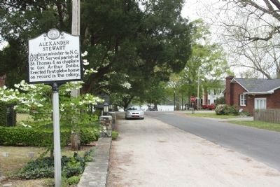
Anglican minister to N.C., 1753-71. Served parish of St. Thomas & as chaplain to Gov. Arthur Dobbs. Erected first glebe house on record in the colony. — — Map (db m65664) HM
This site marks the former location of the Bath African Methodist Episcopal Zion Church. The AME Zion denomination, chartered in New York City in 1801, began in the 1790s when discrimination against African American Christians forced them to . . . — — Map (db m65673) HM
Bath, originally the Indian town of Pampticough, was settled by white men about 1690 and incorporated in 1705. It is the oldest town in North Carolina. Its first commissioners were John Lawson, Joel Martin, and Simon Alderson. Here was founded in . . . — — Map (db m64799) HM
Bath, oldest town in North Carolina, was established in 1705. The first settlers were French Huguenots from Virginia. Among the early English inhabitants were John Lawson, author of the first history of Carolina (1709) and Christopher Gale, Chief . . . — — Map (db m67574) HM
The road from New England to Charleston, over which mail was first carried regularly in North Carolina, 1738-39, passed near this spot. — — Map (db m65358) HM
Bath, the oldest incorporated town in North Carolina, was established in 1705. By the 1708 the town consisted of twelve houses and a population of fifty people. Among the early inhabitants were John Lawson, Surveyor General of the colony and . . . — — Map (db m67575) HM
Agricultural reformer, a founder of the State Fair, published and edited the "Farmer's Journal", 1852-53, in Bath. This was his home. — — Map (db m67567) HM
Naturalist, explorer and surveyor general for the Lords Proprietors, John Lawson traveled the interior of the Carolina colony in 1700-01. He described the 550-mile journey in A New Voyage to Carolina, published in 1709. Lawson was killed by . . . — — Map (db m67573) HM
Colonial home of Colonel Robert Palmer, Surveyor-General of North Carolina 1753-1771 and Collector of Customs for the Port of Bath. Built c. 1744, probably by Michael Coutanche, it is one of the oldest surviving dwelling-houses in the State. . . . — — Map (db m66701) HM
1704-John Lawson surveyed 1st 71 lots in Bath.
1710-Thomas Harding, first recorded shipbuilder in Colony, contracted by Gov. Thomas Cary, to build sloop in Pamlico area.
1715-Harding named Town Commissioner & Vestryman. He owned Lots 27-28 at . . . — — Map (db m226318) HM
[ Main Text: ]
This railroad station was built by Norfolk & Southern Railway in 1903 at a cost of $4,824. Its primary purpose was to serve the needs of lumber businesses, most notably the Interstate Cooperage. In the same year as the . . . — — Map (db m299661) HM
Site of Confederate batteries on Pamlico River which enabled General D. H. Hill's forces to besiege Washington in spring of 1863. Five miles east. — — Map (db m52837) HM
(side 1)
This cemetery is the burial ground for the Episcopal congregation of Trinity Church Chocowinity.
The Rev. Nathaniel Blount of Chocowinity, a missionary of the Society for the Propagation of the Gospel, established Trinity . . . — — Map (db m226573) HM
Episcopal. Was originally Blount's Chapel. Built nearby ca. 1774 by Rev. Nathaniel Blount, who served until his death, 1816. Moved here, 1939. — — Map (db m276396) HM
Episcopal boys school founded in 1851 by The Rev. N.C. Hughes. Open off and on until 1908. Many students entered ministry. Stood here. — — Map (db m52835) HM
Mural depicting an abolitionist working on a wharf in Washington, NC providing secret clues for the freedom seekers. This area was a well-known escape route on the Underground Railroad for the enslaved.
Mural commissioned in May 2022 . . . — — Map (db m276393) HM
Prior to formation of 1st N.C. Colored Volunteers, about 100 black men were armed to aid Union forces during the siege of Washington in 1863. — — Map (db m114466) HM
To the Sons of
Beaufort Co.
who served in the
World War
1914 - 1918
Beaufort County Casualties in World War I
James Baugham • Gilbert Bonner • David Boyd • Joseph Brooks • James Carter • Horace Cowell • Allen Cuthrell • Alfred G. . . . — — Map (db m242003) WM
Congressman from New York, 1821-39; House leader for Jackson & Van Buren; minister to Russia; merchant. Was born in this town, 1786. — — Map (db m65820) HM
Governor, 1889-91, state Adjutant General, 1863, Confederate officer, superior court judge, state legislator. His home was here. — — Map (db m65862) HM
Erected May 10, 1905 by Washington Gray Chapter Children of the Confederacy, organized in 1897 by Margaret Arthur Call. To the memory of 17 soldiers killed in defense of Washington Sept. 6, 1862. — — Map (db m276374) WM
Native of Washington, Zurich graduate, head of a Boston hospital, 1st woman member N.C. Medical Society, 1872. Her girlhood home was here. — — Map (db m66169) HM
Booker T. Washington visited November 2, 1910 on educational tour. Around 1000 people attended speech here at Brown's Opera House. — — Map (db m293743) HM
Washington's original "free" church, open to all denominations, was constructed on lot 50 of the town's plat, created by Col. James Bonner, the founder of Washington, circa 1776. Bonner and two other Revolutionary War soldiers are buried here. . . . — — Map (db m226315) HM
This garden is dedicated to the Men and Women who served our nation in peace and in war with honor and devotion. The flag flies in honor of All Veterans — — Map (db m226317) WM
This building which served the thriving shipping industry of early Washington was built in the early 1800's by Jonathan Havens (1744-1828). Its restoration in 1979 was made possible by a gift from Jonathan Havens Moss in memory of the Havens family. . . . — — Map (db m70501) HM
In 1830 talented shipwright and freed slave Hull Anderson built a prosperous shipyard three blocks west of here, before moving to Liberia. — — Map (db m224083) HM
Though officially names Windmill Creek, waterway is better known by a name of African American man who lived by early Windmill. — — Map (db m226307) HM
Allbright, Vern C. • Ball, James Charlie • Barrington, Lloyd T. • Beacham, Clyde W. • Bishop, John Judkins • Braddy, Earl D. • Gragaw, Henry Churchill • Brinson, James W. • Brooks, Leland F. • Brooks, Leon Murl • Burbage, Joseph C. • Calvert, . . . — — Map (db m226603) WM
After the Civil War, women’s associations throughout the South sought to gather the Confederate dead from battlefield burial sites and reinter the remains in proper cemeteries, while Confederate monuments were erected in courthouse squares and . . . — — Map (db m76917) HM
To protect Confederate supply lines and to gather much-need provisions in eastern North Carolina, Gen. Daniel H. Hill planned demonstrations against Union-occupied New Bern and Washington in March 1863. He acted under orders from Gen. James . . . — — Map (db m70502) HM
Purple Martins are native songbirds in the swallow family. They have long been one of America's favorite birds, loved for their beautiful song, graceful flight, social antics, and insect-eating habits. Purple Martins nest in groups called . . . — — Map (db m276385) HM
Finished in 1883, Demolished around 1960
The view from this location is looking south towards the river around 1920. The building at the end of Market was known as the Washington Market House and was used for the sale of meat, fish and produce. . . . — — Map (db m276394) HM
After Union Gen. Ambrose E. Burnside’s army captured Roanoke Island in February 1862, Federal troops occupied New Bern the next month and then secured the undefended town of Washington on March 20. Although several weeks passed with only a few . . . — — Map (db m211803) HM
During the summer of 1862, Union forces firmly controlled eastern North Carolina, with garrisons stationed at Plymouth, Washington, New Bern and elsewhere. Federal detachments raided the countryside at will, while Confederate authorities struck . . . — — Map (db m64899) HM
The Original Washington
The history of Washington began around 1585 when English explorers first visited the area that would become Washington. The easily navigable waters and excess of natural resources made the area a very successful port . . . — — Map (db m226611) HM
Founded in 1776, the Town of Washington, North Carolina, was the first City in America to be named for General George Washington. Because of this, the city is still occasionally referred to as "Original Washington."
The scars of the Civil . . . — — Map (db m276387) HM
Founded in 1776, the Town of Washington, North Carolina, was the first City in America to be named for General George Washington. Because of this, the city is still occasionally referred to as "Original Washington."
The scars of the Civil . . . — — Map (db m276389) HM
Weather Signal Flags
Beginning in 1873, the U.S. Army Signal Service distributed forecasts to thousands of rural post offices for display as "Farmers' Bulletins." In 1881, signal flags, like the ones shown here replaced the bulletins. With the . . . — — Map (db m276381) HM
To commemorate
the 200th Anniversary of
Washington, North Carolina
The first town
in the United States
to be named for
General George Washington
Originally known
as "town at the forks of the
Tar River." It was settled . . . — — Map (db m70505) HM
Not only does weather influence the estuary, the estuary can influence the weather as well. How they interact with each other plays a critical role in determining who and what lives here.Cooler by the Water
On hot . . . — — Map (db m276382) HM
Plantation setting for the novel "Bertie," by George R. Throop (1851), tutor in the family of Geo. W. Capehart. House built 1838 is 8 mi. S.E. — — Map (db m56987) HM
Along the banks of the Chowan River and Salmon Creek, the seeds were planted for the colony and state of North Carolina. From these roots in the 1600s emerged the refined plantation life of the ruling colonial gentry in the 1700s, made possible by . . . — — Map (db m56927) HM
Built 1858 by Patrick H. Winston, Jr. Birthplace of sons George T., educator; Francis D., lt. gov., 1905-1909; & Robert W., writer. 100 yards east. — — Map (db m60651) HM
Early Native Americans built canoes by hollowing out long sections of trees (usually cypress trees). They often used fire to help hollow and shape the log.
European settlers saw how well dugouts worked on the region’s waterways and began making . . . — — Map (db m256367) HM
In the days before electricity and refrigerators, many people built a kind of half-basement under a home or shed called a “root cellar” to store food.
The natural insulation of the ground lets root cellars maintain a fairly constant . . . — — Map (db m60732) HM
To disrupt Confederate recruiting efforts here in Windsor, the Bertie County seat, three Federal transports steamed from Plymouth on the night of January 29, 1864, under U.S. Navy Lt. Cmdr. Charles W Flusser. USS Whitehead and USS . . . — — Map (db m60627) HM
Windsor's residents slept peacefully the night of January 29-30, 1864, unaware of what the morning would bring, as U.S. Navy Lt. Cmdr. Charles W. Flusser led three gunboats their way to disrupt Confederate recruiting efforts. USS Massasoit . . . — — Map (db m226118) HM
William Gray in 1776 set aside 100 acres at Gray’s Landing for establishing a town. 18th century travelers would have disembarked from sailing vessels docked at the foot of King Street at the old Gray’s Landing site. Visitors to Windsor today, . . . — — Map (db m60629) HM
This boat was recovered from the muddy bottom of the Cashie River in 2004. It is the type utilized by commercial fishermen on our local sounds and rivers years ago.
Robert (Bob) Smithwick was a farmer, owner of a country store at Sans Souci and . . . — — Map (db m256365) HM
Created by an act of Colonial Assembly in 1768, New Windsor was established on the site known as Gray’s Landing. A part of grants to the Lords Proprietors, 2800 acres on the Cashie River were sold in 1717 by John Lord Carteret, Earl of Granville to . . . — — Map (db m60630) HM
The Confederate ironclad ram Albemarle, led by Capt. J.W. Cooke, crossed Batchelor's Bay, May 5, 1864, and fought seven Union warships 15 mi. E. — — Map (db m56990) HM
Founded by Edward Perry in 1889.
Owned and operated by son William Lewis Perry in the early twentieth century.
Gift to the Town of Windsor by Mackie Perry McKean in memory of her father William Lewis Perry — — Map (db m276363) HM
This brick vault was once housed in the depot of the Wellington and Powellsville Railroad.
The W&P ran between Windsor and Ahoskie in the early to mid-1900’s carrying produce and passengers.
There was a hill on the train’s route it often . . . — — Map (db m256370) HM
Recognized since 2008 as part of the National Underground Railroad Network to Freedom the Roanoke River was an important passageway for Antebellum freedom seekers — — Map (db m276365) HM
These graves were discovered during site preparation for Roanoke/Cashie River Center.
They were overgrown with vines and shrubs, and had not been tended in many years.
One grave dates to 1884. No date is found on the other headstone. . . . — — Map (db m60733) HM
Acting on orders from General Robert E. Lee in the winter of 1863-64, Confederate forces under the command of Major General George E. Pickett were deployed throughout eastern North Carolina preparatory to as an attempt at clearing the enemy from the . . . — — Map (db m60628) HM
This brick vault was once housed in the depot of the Wellington and Powell Railroad.
The W&P ran between Windsor and Ahoskie in the early to mid 1900’s carrying produce and passengers.
There was a hill on the train’s route it often had . . . — — Map (db m60730) HM
Member of Continental Congress, signer of the Federal Constitution, governor S.W. Territory, Senator from Tennessee. Birthplace ⅕ mi. S.W. — — Map (db m60649) HM