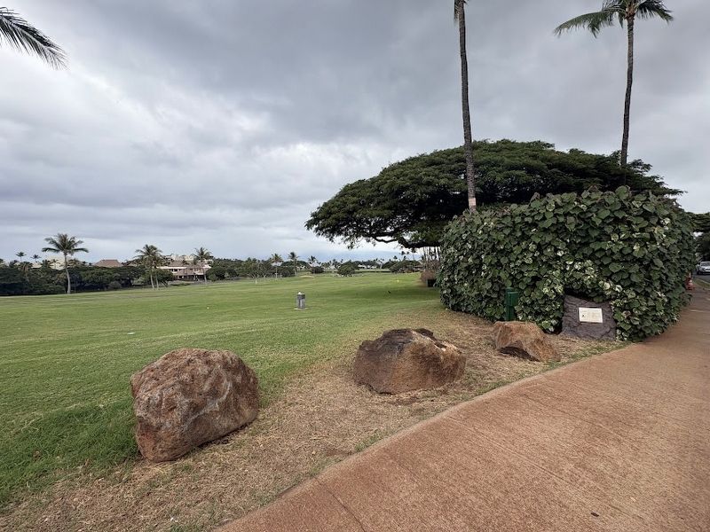
The Stones of Moemoe and Wahine O Manua These two large pohaku (stones) are steeped in legend. The larger one is over six feet long and resembles a reclining person. It is called Moemoe (to lie in wait or sleep). The taller stone sheltered an abused . . . — — Map (db m290120) HM
Beginnings:
These gardens started
as a dream guided by the
visionary Rene Sylva.
His transformation into
a passionate conservationist brought him
from a stint in the military and time spent in
construction to fishing, where Rene was . . . — — Map (db m297567) HM
This 1990 Caterpillar 772B
was part of the last fleet of cane
haulers at the Hawaiian Commercial
& Sugar Company's Puunene mill,
which closed in 2016. At auction,
the Cat sold with 54,584 miles
on it. In an act of preservation,
Clive and . . . — — Map (db m297393) HM
This trencher, manufactured
in 1972, was used to "furrow"
the fields for irrigation.
It is capable of digging a trench
six feet deep and more than two
feet wide. — — Map (db m297188) HM
This Corliss engine powered
Alexander & Baldwin's Puunene Mill
from 1903-1981. It weighs 50 tons,
holds a 24 ft. flywheel, and is capable
of 1500 horsepower. The Sugar Museum
acquired the engine in 2014. It was
erected on the museum . . . — — Map (db m297391) HM
This cable crane and its "grab" were
manufactured in 1959. They were used
to grab, lift and load harvested sugar cane
into haulers bound for the sugar mill.
This crane was used by Pioneer Mill
Company in Lahaina. Upon closure of that
mill . . . — — Map (db m297510) HM
On February 18, 1881, the Norwegian barque Beta captained by C. Rist-Christensen, dropped anchor in the sheltered cove of McGregor Point. Days later, after being tagged with numbers and divided by lot, 228 adults and their children were assigned . . . — — Map (db m297512) HM
The Portuguese oven was a necessity for the
immigrants who came here to work on the sugar
plantations. While it was sometimes used to
roast meat or poultry, the oven's primary purpose
was used to bake bread, which was a daily staple.
This . . . — — Map (db m297511) HM
These pots were used
by whalers in the 1800s
to "try-out" or render whale
blubber into oil.
Early sugar processors
used these pots to boil
cane juice. — — Map (db m297394) HM
Designed by Arnold Palmer and Francis Duane
Opened October 1975
The first golf course in the United States
to be designed a certified
Audubon Cooperative Sanctuary by Audubon International in 1993
This property is being managed with . . . — — Map (db m292904) HM
The island of Lana'i, seen here from above the sugar cane fields of the former Pioneer Mill, has always had close connections with West Maui. In ancient times, Maui ruler Kaka'alaneo lived along this coast. The chief's mischievous son, . . . — — Map (db m293018) HM
Cook Pine trees were discovered by Captain Cook, and brought to Hawai'i from New Caledonia. When young, they are sometimes mistaken for the Norfolk Pine tree that retains its wider cone shape into maturity. While the Cook Pine grows in . . . — — Map (db m292785) HM
Honolua Plantation manager D.T. Fleming was acclaimed a visionary. In 1932 he started planting the African import known as aloe and by 1941 had over 25 acres of the crop in cultivation. Convinced of the plant's medicinal properties, he began . . . — — Map (db m292787) HM
Look down over the seawall to the boulders below, and
you will notice an unusually shaped stone, which remarkably resembles a chair with a spacious seat and short angular back. Look closely, and you will see that the seat portion is worn down . . . — — Map (db m290069) HM
Honokahua is the site of an estimated 2,000 ancient Hawaiian burials dating between AD 610 and 1800. Hawaiians believe that from such a place ancestor spirits continue to lovingly watch over the land and it's people. Today the burial mound is . . . — — Map (db m293016) HM
Honokahua's Hawaiian Heritage is preserved on 13.6 acres surrounded by a naupaka hedge. Here, Hawaiian remains dating between AD 850 and the early 1800s are interred and segments of Alaloa, an ancient stone paved trail, are preserved. . . . — — Map (db m293017) HM
Built in 1929 by pineapple plantation carpenters, the company store was once the central gathering place for the village residents. It was here that plantation workers brought most of their supplies, caught up on the news of the day and read . . . — — Map (db m292906) HM
Created on Old Coastal Road in the early 1960's, to transport personnel & materials into West Maui's new destination resort developed by AMFAC, Inc.
Runway 01-19 began just 80 feet from this shoreline, and extended north 2615 feet surrounded . . . — — Map (db m293022) HM
This pier once stretched far into the
ocean. It operated for many years as the
primary loading spot for shipping
processed sugar from the island and
bringing in supplies for the plantation
camps. Railroad tracks led from the
sugar cane fields . . . — — Map (db m290122) HM
Named after the famous battle between two royal brothers who fought in the area, a race track stood right on this sandy beach. It was built for horse racing, which was a favorite sport of many members of Hawaiian royalty as well as plantation owners . . . — — Map (db m290124) HM
The Lahaina Court & Custom House was first built in 1859 with the remains of Hale Piula, the unfinished coral palace of King Kamehameha III. From its opening in 1860, it served as a customs house for the whaling and trade ships and a center for . . . — — Map (db m290068) HM
In Hawaiian, Maka oi oi means, sharp eyes, or more loosely translated beautiful view. On this site in 1914, David T Fleming, manager of Honolua Ranch, built a home for his family where it is said they enjoyed an idyllic life in this pastoral . . . — — Map (db m292901) HM
Hanaka'ö'ö Cemetery, across the road behind you, is the final resting place of some of the immigrants who came to work in Hawai'i's sugar and pineapple plantations. Like the women shown in this photo, these immigrants labored in hot, dusty fields so . . . — — Map (db m293020) HM
This famous dark lava rock promontory is named Pu'u Keka'a in Hawaiian, which translates as "the rolling hill." To this day, it is revered as a sacred spot known as "ka leina a ka 'uhane" - the place where a soul leaps into eternity.
One of . . . — — Map (db m290125) HM
This monument commemorates the arrival of the Norwegian barque Beta which dropped anchor near this spot on February 18, 1881, and of her sister ship Musca, which arrived in Honolulu May 13, 1881. They brought more than six hundred . . . — — Map (db m73188) HM
Completely restored in 1982 to its original appearance, the Seamen's House was first built in 1833 on the
commission of King Kamehameha III. At the time, Lahaina did not extend much farther north than Dickenson
Street, which was then a stream . . . — — Map (db m297226) HM
The Honolua Plantation Office, headquarters for pineapple growing and canning operations in this region, was relocated from the Honolua lowlands to this site in 1912. More than 90 years old, this structure is the oldest remaining building in this . . . — — Map (db m293015) HM
This 10,000 pound invention of William
Porter was designed to permit large
sailing ships to swing in tidal currents
without fouling their anchor chains.
The secret was in the pivoting flukes
that allowed one arm to fold back
against the . . . — — Map (db m297565) HM
We proudly dedicate this plaque and tree (planted July 2, 1981) in rememberance of all the living and deceased members of the 726th searchlight battery and as an expression of our affection for the warm and loving people of Maui who welcomed us. . . . — — Map (db m292724) HM WM
Dedicated on December 16, 2000 in celebration of the centennial of the arrival of the Puerto Ricans in Hawaii on December 23, 1900
Back Of Marker - English
The Puerto Ricans
In December 1900, the Puerto . . . — — Map (db m292751) HM
Kamehameha I from the island of Hawai'i began waging battles to unite all the islands under
waging battles to unite all the islands under his rule in the late 1780s. In 1790, he landed along Kahului Bay with a large fleet of canoes. At Wailuku, . . . — — Map (db m292779) HM
Offering a cool retreat from the heat of the day, buildings like this were important community exchange centers in rural China. Farmers would slip into the shade of these "cooling gazebos" to rest from laboring in the fields, and catch up on . . . — — Map (db m292749) HM
This tree is dedicated to the victims of the March 11, 2011 earthquake and tsunami in Japan
On March 11, 2011, a 9.0-magnitude earthquake struck the Tohoku Region of Japan. The devastating tsunami generated by this earthquake took the lives of . . . — — Map (db m292728) HM
The early Chinese were drawn to Hawaii by the economic opportunities that these
dramatically beautiful and blessed islands offered. They settled on Maui in the last
half of the 1800s and early 1900s. The early Chinese pioneers played a vital . . . — — Map (db m292746) HM
The eight depressions in these basalt boulders are believed to be the result of the shaping and sharpening of stone adzes. Using sand and water, the edges of the stone to be shaped were ground against these boulders to form the adzes leaving . . . — — Map (db m293019) HM
Asian migration to Maui began in the 1880's with the arrival of the first Japanese laborers. Many found work in the sugar cane fields, while others became fishermen and settled in coastal villages such as Ma'alaea. Perpetuating homeland . . . — — Map (db m290129) HM
A heiau is a Hawaiian religious structure which centralized the ceremonies and rituals of old Hawaii. The construction of a heiau was directed by the highest chiefs or alii and required a great expenditure of organized labor. The ceremonies and . . . — — Map (db m71864) HM
The earliest settlers of African ancestry arrived in Hawai'i well before the missionaries' 1820 arrival. Until Hawai'i became a territory in 1898, many of these black immigrants were active in the community as advisors, entrepreneurs . . . — — Map (db m292723) HM
This Kwai Mi Lychee tree was planted on February 11, 1989 by Hannibal Taveres, Mayor of the county of Maui in commemoration of the 200 years since the first arrival of the Chinese in Hawaii. Assisting in the bicentennial tree planting ceremonies . . . — — Map (db m292750) HM
In commemoration of the arrival of the first Japanese Immigrants to Hawai'i February 8th, 1885
Erected by the Japanese of Maui on the Fiftieth Anniversary - 1935
Re-erected by the Japanese of Maui on the Seventy Second Anniversary . . . — — Map (db m292727) HM
The Japanese teahouse is rustic architectural style that grew out of the development of Chado, the Way of Tea. Chado is a philosophy that blends the simple act of preparing, serving and drinking green tea with Zen Buddhist tradition. Because the . . . — — Map (db m292742) HM
One hundred years ago the first government contract immigrants from Japan set foot on these shores and entered the banks of the sugar industry labor force. By 1924, when Japanese immigration was effectively ended by a new American immigration . . . — — Map (db m292743) HM
Commonly called ʻĪao Needle, the traditional Hawaiian name for this 2,250 foot high peak is Kūka‘emoku. This peak is known as the phallic stone of Kanaloa, Hawaiian god of the ocean.
During periods of warfare, the peak was . . . — — Map (db m31540) HM
The traditional name for this 2,250 foot high peak is Küka'emoku. The peak is known as the phallic stone of Kanaloa, Hawaiian god of the ocean.
During periods of warfare, the peak was used as a lookout by warriors. It was here that some of . . . — — Map (db m292777) HM
A thousand years ago, Hawaiians gathered
at Iao Valley to celebrate and honor the
bounty of Lono, god of agriculture, during the
annual makahiki festival. More than a hundred
years ago, visitors began coming to witness the
natural beauty of . . . — — Map (db m292782) HM
Iao translates as "cloud supreme" and refers to
the bank of clouds that often sits over the valley.
These clouds bring the frequent rains that feed
the streams. It is these waters that carved this
landscape over the past 1.5 million years. . . . — — Map (db m292783) HM
In commemoration of the 100th Anniversary of the XinHai Revolution,
which marks the birth of Modern China. The Sun Yat-sen Foundation
for Peace & Education proudly dedicates this bronze statue in memory
of Dr. Sun Yat-sen, who was once a . . . — — Map (db m292745) HM
A century has elapsed since the first Korean emigrants who left jemulpo Port, arrived in the port of Honolulu, Hawaii on January 13, 1903. The emigration was a historic moment for the Korean people, who had never experienced a world outside of . . . — — Map (db m292726) HM
Along this trail you will see plants brought to Hawai'i by the early Polynesians. Kalo (taro) was the staple crop and fields of kalo once covered the floor of Iao Valley. The wetland variety is cultivated on level earthen terraces known as lo'i. . . . — — Map (db m292780) HM
Navigators! Visually, the open ocean is a featureless environment. This makes it difficult to use sight for navigation. Hammerhead sharks can travel vast distances across the ocean by detecting electromagnetic fields around the Earth. . . . — — Map (db m71861) HM
In the distant future, when our descendants ask, tell them here lies the first altar made by Korean American Christians.
Today, when more than three thousand Korean churches in America, along with their members ask, tell them you all are . . . — — Map (db m73191) HM
The steams of the valleys of Waikapu, Wailuku, Waiehuu, and Waihe'e are known as the four waters. The fertile lands and abundant water made this area the largest irrigated agricultural system in Hawai'i and a major population center of Maui. . . . — — Map (db m292778) HM
The people who lived in this kind of house in the early 1800's were mostly from New England. They came to Hawai'i either as traders and merchants or as missionaries sent by the American Board of Commissioners for Foreign Missions (ABCFM) of . . . — — Map (db m292725) HM
In prehistoric times, travellers from Olowalu
walked along the shoreline to this spot and then had
to choose whether to swim around the sea cliffs, find
a friendly neighbor with a canoe, or climb over
Kealaloloa Ridge to get to Ma'alaea. In . . . — — Map (db m292719) HM
From islands in the Atlantic to islands in the Pacific, Portuguese came. This miniature house, representing the architecture of Portugal, commemorates Hawai'i's Portuguese immigrants. Settlers from the Portuguese islands of Madeira and Azores . . . — — Map (db m292722) HM
The VBAU 'Paravan' communication buoy seen in this exhibit was
discovered washed up on Maui's North Shore in 2016. It most likely
came from a relatively small diesel powered ballistic missile
submarine, called a Golf Class submarine. They . . . — — Map (db m297341) HM
In commemoration of the centennial anniversary of the October 10th, 1911 Xinhai Revolution,
which marks the founding of Modern China, the Maui Chinese Community have gather together
to celebrate the memory and legacy of Dr. Sun Yat-sen, who was . . . — — Map (db m292747) HM
From the highest peak of Pu'u Kukui to the
shoreline of Kahului Bay, the ahupua'a (land
division) of Wailuku was a favorite place of ali'i
(chiefs) and a ruling center of Maui. Iao Valley is
part of this ahupua'a.
As one of Maui's most . . . — — Map (db m292781) HM
Follow in the footsteps of travellers from over a century ago. Built for horseback and foot travel between Wailuku and Lahaina, the Lahaina Pali Trail was the direct route across the steep southern slopes of West Maui mountain. It was hand-built . . . — — Map (db m292720) HM