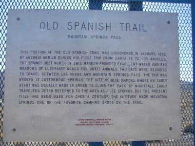
This portion of the Old Spanish Trail was discovered in January, 1830, by Antonio Armijo during his first trip from Santa Fe to Los Angeles. The spring just north of this marker provided excellent water and fed meadows of luxuriant grass for draft . . . — — Map (db m270155) HM
James B. Wilson, a gold miner and veteran of the Civil war, arrived in southern Nevada in 1869. He first started a ranch near the original Las Vegas Rancho, but sold that property. In 1876 he homesteaded the Sandstone Ranch on this location with . . . — — Map (db m205214) HM
Stretching for 130 miles across Clark County, this historic horse trail became Nevada's first route of commerce in 1829 when trade was initiated between Santa Fe and Los Angles. The trail was later used by the wagons of the "49ers" and Mormon . . . — — Map (db m29218) HM
Pat Tillman died a warrior.
Mike O'Callaghan lost a leg in combat but is better known for the battles he fought in the political arena.
They were good citizens—two of America's finest.
Donal Neil “Mike” O'Callaghan (1929-2004)
Mike . . . — — Map (db m269060) HM
Originally a Native American trail, Bootleg Canyon – also called the Hooch Highway was a well-known backdoor into Boulder City and the Hoover Dam construction site during prohibition. Bootleggers brewed illegal alcohol in stills hidden in . . . — — Map (db m29324) HM
Building the dam required thousands of hands. At least 21,000 workers were required during construction. Approximately six miles from the dam city, Boulder City was constructed to provide accommodations for the workers.
Top
Panorama of . . . — — Map (db m254570) HM
The name of the dam has changed over the years, but the remarkable feat transcends names. The modern name is Hoover after the U.S. president in office during the initial construction. The Hoover Dam, the height of a 60 story building, is the . . . — — Map (db m254579) HM
Hoover Dam has been a magnet for tourists - and their cars -
from the earliest years of its construction.
The Memorial Bridge has reduced the number of vehicles traveling across the dam. This not only improves the visitor experience but also . . . — — Map (db m285147) HM
Best Crossing Site
Seeking the best new bridge site was one of the first major decisions in bypassing the river crossing atop Hoover Dam.
The Project Management Team (PMT) identified 13 alternative routes early in the project. These . . . — — Map (db m285199) HM
One of the finest examples of how civil engineering ingenuity shaped the development of society's quality of life in the 20th century. — — Map (db m31900) HM
From Water to Watts
The nearby switchyards, towers, and high voltage power lines deliver electricity from Hoover Dam generators to Southwestern cities.
The Western Area Power Administration (WAPA) operates and maintains the Hoover - . . . — — Map (db m285167) HM
The task of completing the dam was both immense and treacherous, but the project was completed in 1935, just over four years from the start. The dam was designated a National Historic Landmark in 1985. The National Park Service has been on site . . . — — Map (db m254568) HM
Planning and designing the Memorial Bridge took two years, during which multiple options for its design were considered.
Five types of bridge designs were evaluated for their costs, aesthetic appeal, and capacity to withstand high winds, . . . — — Map (db m285150) HM
Design Philosophy of the Bypass Corridor
The Project's Corridor Design Manual presented principles for combining design aesthetics with efficient structural engineering to assure that the design excellence of today would honor that of Hoover . . . — — Map (db m285230) HM
The Bureau of Reclamation welcomes you to Hoover Dam, one of the exceptional engineering achievements of the 20th Century.
Hoover Dam and Lake Mead have provided a reliable supply of water and affordable electricity to the people of the . . . — — Map (db m285528) HM
The Bureau of Reclamation welcomes you to Hoover Dam, one of the exceptional engineering achievements of the 20th Century.
Hoover Dam and Lake Mead have provided a reliable supply of water and affordable electricity to the people of the . . . — — Map (db m292495) HM
Born in 1858, Dr. Elwood Mead became a world-renowned water and irrigation engineer. He wrote Wyoming's first water code, the basis for codes throughout the United States, Australia, Canada, South Africa and New Zealand. He wrote the Carey Act, led . . . — — Map (db m31902) HM
Eldorado Canyon runs east from here to the Colorado River and was the site of one of Nevada's mining booms. Prospectors began digging for gold and silver here, about 1859, forming the Colorado Mining District. The three largest mines, the . . . — — Map (db m29328) HM
Respect the Landmark
The designers and builders of Hoover Dam showed pride in their creation and respect for the future generations that would marvel at the visual quality of their work.
The artist's attitude as much as any engineering . . . — — Map (db m285165) HM
Land Surveying Above
The bridge engineers needed accurate measurements of the land surface to help them fit the River Bridge perfectly into the rugged canyon.
Land surveyors carefully drew topographic maps to record the width of the . . . — — Map (db m285521) HM
Rock Anchors
To protect the foundations and stabilize the slopes, rock anchors tightly hold together the fractured rock faces on slopes and cliffs.
Geotechnical (rock and soil) engineers determined where they must stabilize the slopes . . . — — Map (db m285522) HM
The building of Hoover Dam was a ray of hope for a nation struggling
with hard times. Newsreel images of the high-scalers who worked the
canyon walls ignited public interest in the project.
"Scaling" is the process of removing loose rock . . . — — Map (db m111191) HM
Since 1935, Hoover Dam and Lake Mead have provided flood control, irrigation, drinking water, and power to communities in the desert. These resources have transformed the southwest into production farmland and thriving communities. The dam was . . . — — Map (db m31879) HM
This project team was commissioned to manage and build 15 miles of Interstate 11 from concept through completion. This segment of Interstate 11 marks the first new Interstate Highway System to be built since it was deemed complete on October 14, . . . — — Map (db m297966) HM
Established in 1964, the Lake Mead National Recreation Area (NRA) encompasses two reservoirs, Lake Mead and Lake Mohave, three rivers (Colorado, Virgin, and Muddy) and is at the heart of a network of surrounding national parks, national monuments, . . . — — Map (db m254446) HM
Lake Mead began filling in 1935 while Hoover Dam was under construction. It is the largest man-made reservoir in the United States and is approximately 112 miles long with 247 square miles of surface and a depth of approximately 500 feet when at . . . — — Map (db m254445) HM
Hail & Farewell
U.S. 93 enters and exits Nevada and Arizona near the Hoover Dam in the most dramatic manner of any U.S. highway crossing state lines.
Before the River Bridge opened, the original highway twisted down and up the cliffs of . . . — — Map (db m285525) HM
In 1930, Michael McKeever set up a small tent house in Hermenway Wash slightly north of Government Survey Camp #1, where he was a government cook. Soon other workers started building homes nearby, and the area became known as McKeeversville. . . . — — Map (db m69447) HM
May all who cross the canyon on this memorial bridge travel their life journeys with the strength and inspiration found in the high ideals and heroic deeds of these brave humble men.
In Memory of these men of heroic sprit who overcame . . . — — Map (db m46836) HM
Traffic congestion created the need for a bridge to bypass the road across the top of the dam. The Mike O'Callaghan - Pat Tillman Memorial Bridge, which opened on October 19, 2010, meets that need.
The halogen flood lights used for night work . . . — — Map (db m285237) HM
In 1902 the Reclamation Act provided for the creation of what is now called the Bureau of Reclamation (BOR). Primarily engineers, they sought potential water development projects in western states with federal lands. The Colorado River was chosen . . . — — Map (db m254571) HM
Plants & Wildlife
The contractors protected or moved native plants before starting to build.
They collected many plants and stored them in a nursery. Later, they replanted vegetation on the site. Environmentalists also harvested seeds of . . . — — Map (db m285520) HM
Legend has it there are many workers buried in Hoover Dam. However, due to the manner in which the Dam was constructed, this would have been impossible. "Puddlers" directed buckets of concrete over empty forms, released the concrete, and then used . . . — — Map (db m39488) HM
Roadway Framing & Deck
This efficient bridge design that combines steel and concrete members does the same work as would an all-concrete bridge, but at a much lighter weight. It also eliminates many braces between columns that would clutter . . . — — Map (db m285159) HM
Origin of the Dam
In 1902 the Reclamation Act provided for the creation of what is now called the Bureau of Reclamation (BOR). Primarily engineers, they sought potential water development projects in western states with federal lands. The . . . — — Map (db m257802) HM
Innovative Design for the Deck Arch Bridge
The Design Team worked through six deck arch options to find one for the best form and function, a unique hybrid structure with a concrete arch coupled with a composite steel superstructure. . . . — — Map (db m285523) HM
From start to finish, building the Memorial Bridge took nearly a decade. Five years were needed for design work, the relocation of the electrical transmission line, and the construction of new highway approaches.
The bridge itself took another . . . — — Map (db m285202) HM
The Colorado River drains roughly 243,000 square miles and winds along a 1,450 mile course from Colorado to the Gulf of California. Diversion and dams along the Colorado River began in 1905, with the most recent completed in 1970. Numerous other . . . — — Map (db m254565) HM
The Hoover Dam mascot only acted like he owned the dam,
but without a doubt, he owned the hearts of its workers.
The dog wandered freely around the job site; up ladders, over catwalks and
through tunnels. He even rode the open-air elevator . . . — — Map (db m111204) HM
The Hoover Dam construction crew’s mascot was found as a
puppy by workers at the construction camp. This dog traveled
to and from the dam site with them and spent his days visiting
the many work areas. On February 21, 1941, the life of this . . . — — Map (db m111203) HM
Journeys & Heroes
The Life & Legacy of Mike O'Callaghan (1929-2004)
Life
Mike O'Callaghan, born on 10 September 1929 in La Crosse, Wisconsin, had hardworking rural beginnings that he never forgot. His parents named him Donal Neil . . . — — Map (db m269088) HM
The Six Companies, Inc. crew blasted tunnels to divert water, faced carbon monoxide-chocked tunnels and worked with jackhammers from heights of 700 feet. Casualties resulted from falling equipment, rocks and workers. This view shows the interior of . . . — — Map (db m254572) HM
In 1938, Transcontinental and Western Air Lines, later Trans World Airlines, began serving Clark County, flying into Bullock Field in Boulder City. The airline believed that Boulder City would be a more lucrative market than nearby Las Vegas, and . . . — — Map (db m46833) HM
Mike O'Callaghan - Pat Tillman Memorial Bridge
The building of the Memorial Bridge did not just have to meet the technical challenges of designing and construction. They also had to do their jobs next door to the iconic Hoover Dam - a . . . — — Map (db m285158) HM
When the government built Boulder City, it didn't plan for children. But, as the Depression drove workers into southern Nevada to build Hoover Dam, workers brought their families with them. The new town and surrounding desert provided an exciting . . . — — Map (db m71106) HM
Those that came to Boulder City to work on the dam lived in harsh conditions. The oppressive heat of the summers and the unbearable cold of the winters took its toll on many. Even the most mundane chores were difficult in this inhospitable . . . — — Map (db m71107) HM
At the height of Hoover Dam construction, more than 7,000 men labored in Black Canyon. Some jobs were glamorous and exciting, such as the high scalers who swung over the canyon on ropes or the cableway operators who kept concrete buckets moving 24 . . . — — Map (db m39487) HM
Originally founded in 1931 as a community for the workers building Hoover Dam, Boulder City was the first planned community in southern Nevada. Designed by Saco Rienk DeBoer, it was a federal reservation. Only workers associated with the building or . . . — — Map (db m71903) HM
[ Front ]:
"The Old Man"
Francis Trenholm Crowe
Born: October 12, 1882
Died: February 26, 1946
World's Outstanding Builder of Dams
[ Right Side ]:
"We had 5,000 men in a 4000-foot canyon. The problem was to . . . — — Map (db m39485) HM
[ Front ]:
They endured the hardships so all of America might prosper
This Memorial was contributed by the men and women who built Hoover Dam to commemorate the 50th anniversary of its dedication
September 30, . . . — — Map (db m39486) HM
This cast steel turbine runner (water wheel), which is 14.2 feet in diameter and weighs over 34 tons, powered the N-7 generator at Hoover Dam Power Plant from 1944 to 1982. The function of a turbine runner is to convert the force of falling water, . . . — — Map (db m29248) HM
The Boulder Dam Hotel has been part of Boulder City history since its opening in 1933. Designed by Mort Wagner the hotel was built by Paul Stewart "Jim" Webb, Raymond Spilsbury, and Austin Clark. It is located in Cardenas Plaza - known today as . . . — — Map (db m39502) HM
Named for an 1890's railroad which was never built, Railroad Pass first became a destination after Professor Robert T. Hill discovered alunite in the area in 1908. A mining district was formed, but only small amounts of gold were found. Mines in the . . . — — Map (db m214462) HM
About two miles in front of you, the remains of the town of Callville lie buried in silt on the bottom of Lake Mead. Originally developed as a port on the Colorado River to supply goods to Mormon settlements, Callville had long been a desolate . . . — — Map (db m3917) HM
Originally known as Stage Field, this was an outlying airfield of Camp Ibis, one of the eleven camps established within the Desert Training Center, California-Arizonan Maneuver Area during World War II. Developed by General George S. Patton, Jr., . . . — — Map (db m78522) HM
This Spring, discovered by Anasazi and Paiute people, sustained the first Mule Train that pioneered the pack route later known as the “Old Spanish Trail” between Santa Fe and Los Angeles. Antonio Armijo, "Commander for the discovery of the route to . . . — — Map (db m268181) HM
During World War II this building was constructed as a barracks at the Tonopah Army Air Field. Pilots and crew occupied buildings like this during their training to fly P-39 and B-24 aircraft. More than 7000 military personnel were stationed in . . . — — Map (db m268170) HM
This small spring, first used by Anasazi and Paiute people, also sustained the caravan that pioneered a pack route now known as the Old Spanish Trail. En route to Los Angeles from Santa Fe, trader Antonio Armijo, 60 men and 100 mules camped here on . . . — — Map (db m39470) HM
In the early 1900s the Robbins Family donated this land for our town’s cemetery. This land is to be used only for burials of bonafide residents of the town of Goodsprings. Please respect our cemetery. It is the final resting place for so many of . . . — — Map (db m268409) HM
Ore deposits readily recognized in the faulted and folded limestone deposits of this district remained unworked until 1856, when the Mormons developed a single lead mine at Potosi—probably the oldest lode mine in Nevada.
Named for . . . — — Map (db m39471) HM
(left stone marker)
Remembering those who served us then, we salute you now
Civil War
Ladd, James H. - G.A.R
World War I
Ellis, William E.
World War II
Cash, Charles W. - US Navy
Farley, Calvin T. - USMC . . . — — Map (db m268406) WM
George Fayle moved to southern Nevada from Calico, California in 1904. He settled at Goodsprings Junction, which was later renamed for his wife Jean. In 1912, he moved to Goodsprings. He built the Pioneer Saloon in 1913, later building the Fayle . . . — — Map (db m39472) HM
The Old Spanish Trail, used by Mexicans and Americans
traveling between Santa Fe and Los Angeles in the early
1800s, passed through land that is now part of this park.
Mexican trader Antonio Armijo linked together footpaths
used by . . . — — Map (db m284396) HM
On January 8, 1830, the first pack train to pass from Santa Fe, New Mexico to Los Angles crossed Las Vegas Valley. Antonio Armijo, a merchant in Santa Fe, commanded the train and roughly sixty men. The successful completion of the journey opened a . . . — — Map (db m29247) HM
Seeking Pay Dirt
In 1908, mining engineer Robert T. Hill staked a claim in Railroad Pass hoping to find gold deposits as rich as those in Goldfield to the north and Searchlight to the south. Hill reasoned that gold could surely be found at . . . — — Map (db m46738) HM
The name, "Arrowhead Trail" likely originated from the former San Pedro, Los Angeles, and Salt Lake Railroad's logo, an arrowhead. Prior to 1850, New Mexican trading caravans from Santa Fe en route to Los Angeles used this segment of the Old Spanish . . . — — Map (db m308212) HM
The man depicted on this monument is performing one of the most dangerous yet essential jobs in the construction of the (Boulder) Hoover Dam. Sitting in a bosun’s chair, hundreds of feet in the air, his job was to set charges and clear the loose . . . — — Map (db m24317) HM
Commissioner, Bureau of Reclamation, Department of the Interior, 1924-1936 whose life-time work culminated in construction of the Boulder Canyon project creating Lake Mead, named in his honor. — — Map (db m1313) HM
The United States of America will continue to remember that many who toiled here found their final rest while engaged in the building of this dam.
The United States of America will continue to remember the services of all who labored to clothe . . . — — Map (db m1311) HM
Founded in 1904 as Goodsprings Junction, a station on the San Pedro, Los Angeles, and Salt Lake Railroad, Jean received its current name in 1905 when the post office was opened. It was named in honor of Jean Fayle, the wife of George Fayle who had . . . — — Map (db m129575) HM
According to the early history of Elko, Nevada, this curfew and fire bell played a vital role for local citizenry. It often rang to signal disastrous fires, deaths of celebrities, and celebrations.
Harbinger of both good tidings and bad, the . . . — — Map (db m201468) HM
The first automobile road to connect Los Angeles and Las Vegas was the Arrowhead Trail Highway. Planned, promoted and built beginning in the second decade of the twentieth century, this was one of the named interstate highways of the Good Roads . . . — — Map (db m103380) HM
On January 30, 1905, near this site, workers drove the last spike that completed the railroad between Salt Lake City, Utah, and Los Angeles, California. This was the last "transcontinental" line to Southern California and one of the last lines . . . — — Map (db m156462) HM
Built in 1911, The Yellow Pine Mining Company Railroad was a twelve and a half mile long narrow gauge railroad connecting the town of Goodsprings with the Union Pacific Railroad here in Jean. The railroad was built using materials from the . . . — — Map (db m107085) HM
Our world changed forever on September 11, 2001.
The people of our nation demonstrated strength and resilience as well as love
and compassion for our fellow man.
In the following days and years, New York New York's Lady Liberty was . . . — — Map (db m255923) HM
Our world changed forever on September 11, 2001.
The people of our nation demonstrated strength and resilience as well as love
and compassion for our fellow man.
In the following days and years, New York New York's Lady Liberty was . . . — — Map (db m255925) HM WM
Stories Over Time
The earliest known southwestern rock images were created by hunter-gatherer Native People several thousand years ago.
Images include representations of humans, animals, and plants as well as abstract designs like . . . — — Map (db m287124) HM
The San Pedro, Salt Lake and Los Angeles Railroad bought Helen Stewart's Las Vegas Ranch in 1902, giving it control of the Las Vegas Springs and the water supply needed for the creation of Las Vegas in 1905. The railroad's subsidiary, the Las Vegas . . . — — Map (db m50274) HM
Bubbling artesian springs flowed here until they were exhausted in the middle of the 20th century, over-pumped to serve the city's growing population.
These springs and the creek they created gave life to the center of the valley. They . . . — — Map (db m51043) HM
This WWII neighborhood was named for the Nevada Biltmore Hotel which opened nearby in 1942. A WWII housing shortage called for the construction of several hundred homes for military personnel and their families. The federal government approved the . . . — — Map (db m51057) HM
The Bow & Arrow Motel was originally installed in Downtown Las Vegas on Wyoming Avenue.
The Allied Arts Council donated the Bow & Arrow Motel sign to The Neon Museum in 2001. — — Map (db m145470) HM
John Steele, one of the original L. D. S. missionaries, secured a mail grant for the Las Vegas Mission. The documents to establish the Post Office, and, appointing William Bringhurst Postmaster, were brought from Salt Lake City by Benjamin H Hulse, . . . — — Map (db m29294) HM
"It will only be for two years," Archibald promised his wife Helen in 1882, coaxing her away from civilized Pioche, Nevada to a ranch in middle of the desert. Two years later, Helen buried Archibald after he lost his life in a gun fight at the . . . — — Map (db m241368) HM
This Jerry's Nugget cabinet rotated atop a vertical tower of letters spelling "Nugget", advertising the popular North Las Vegas local's casino. Circa 1970s, the sign incorporates skeleton neon and hand lettering for lively day and night . . . — — Map (db m92471) HM
In 1855 Pres. Brigham Young appointed a company of men under the leadership of William Bringhurst to establish a colony at Las Vegas. The company left Salt Lake May 10 and arrived at Las Vegas June 14, 1855 and camped near this site. William . . . — — Map (db m234578) HM
Las Vegas had its beginning at this location on June 14, 1855, when thirty-two Mormon missionaries arrived from Utah under the leadership of William Bringhurst. They set to work establishing farm fields that summer, and began to build a 150-foot . . . — — Map (db m160162) HM
After founding Salt Lake City in 1847, the Mormon Church expanded its settlement westward. The Las Vegas Mission was established in June 1855 as an outpost roughly halfway between Salt Lake City and Southern California. Built alongside the Las Vegas . . . — — Map (db m50273) HM
Created in 1962 by architects Wayne McCallister and William Wagner and YESCO design staff. The three-story concave panel of interlocking neon "H" elements formed the corner bullnose for the casino's façade on Fremont Street. At the time, the . . . — — Map (db m92470) HM
Neon guitar signs became the symbol world-wide for the Hard Rock brand. This Las Vegas guitar sign is important because it was the flagship -- the first Hard Rock Café guitar in the world. It graced the corner of Paradise Road and Harmon Avenue . . . — — Map (db m145771) HM
In April 1855, Brigham Young, President of the Church of Jesus Christ of Latter day Saints, called thirty men to leave their families and possessions in the recently settled towns of Utah to serve a mission at the Las Vegas Springs. The verdant . . . — — Map (db m1419) HM
Panel one: The Neon Boneyard Park Sign
The lettering on a neon sign is often the most memorable design component. The Neon Boneyard Park sign includes hidden reference to this aspect of the grand history of Las Vegas signage. Each letter in . . . — — Map (db m71210) HM
Aladdin's Lamp was originally installed in 1966 at the Aladdin Hotel, 3667 Las Vegas Boulevard South.
Restored through a generous donation from Richard Schuetz and presented as a gift, with love, to Mayor Jan Laverty Jones and her children: . . . — — Map (db m64033) HM
On May 15, 1905, in this area, The City of Las Vegas was founded with the auction of lots in Clark's Las Vegas Townsite by San Pedro, Los Angeles & Salt Lake Railroad and Las Vegas Land & Water Company, predecessors of Union Pacific Railroad and . . . — — Map (db m47732) HM
This is a two sided marker
Side A:
Auction Site
At this site on May 15th 1905, the San Pedro, Los Angeles & Salt Lake Railroad auctioned off lots for the creation of the new city of Las Vegas. With 110 degree temperatures scorching . . . — — Map (db m47736) HM