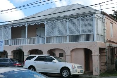
Two story, masonry, residence and shop, with 4 arcades on lower floor and gingerbread trim on second story balcony. Studio of photographer Alex Ovesen and birthplace of Evelyn Richardson. Owners include Samuel Wescott’s children 1864-1950, Wenona de . . . — — Map (db m60817) HM
Along the wharf you would have heard the creaking of rigging and pulleys as ships unloaded foodstuffs, plantation supplies, and building materials. The scent of sugar and molasses sweetened the air. Down the street plodded oxen, snorting with . . . — — Map (db m60815) HM
This building was the third stop in the local chain of commerce. After conducting business at the Scales and Guinea Company Warehouse, merchants and planters paid import and export taxes to Danish customs officials here in the ground-floor . . . — — Map (db m60709) HM
This fort played a vital role in Christiansted’s international trade. Built at harbor’s edge to protect commercial shipping from pirates and privateers, the fort embodied colonists’ fears as well as economic strength. Here were quartered Danish . . . — — Map (db m60707) HM
Since the dawn of consciousness, time has been measured by the movement of the sun. This marker, in the year 2000, is a continuum between all who have come before and all who are yet to come. The design concept starts with the Roman numeral “M”= . . . — — Map (db m60837) HM
This site marks the only point on the United States Territory where members of the crew of Christopher Columbus came ashore on his second voyage to the New World in November 1493. It also relates to the first recorded altercation between . . . — — Map (db m60782) HM
This building was the first Danish Lutheran church on the island—one of the few government buildings not directly involved in international trade. From 1754 to 1831 the Steeple Building was the embodiment of the Danish state religion. All . . . — — Map (db m60711) HM
Eighteenth Century Danish Customs House with nineteenth century addition of the 2nd story gallery. Owner is V.I. Government. Little Altered and in good condition. — — Map (db m60873) HM
The Virgin Islands government had proposed a territorial park for the Reef Bay region of St. John as early as 1937. This led to feasibility studies by the U.S. Department of the Interior to determine if the resources of St. John warranted the . . . — — Map (db m60712) HM
In 1956 Laurance S. Rockefeller, financier and conservationist, donated over 5,000 acres through the Jackson Hole Preserve for the establishment of Virgin Islands National Park. While sailing the Caribbean in 1952, he became enchanted with the . . . — — Map (db m60713) HM
Private philanthropy has a long history and important role in the development of America’s National Park system.
Charitable donations by the Rockefeller family, notably by Laurance S. Rockefeller, helped to establish, enlarge or improve . . . — — Map (db m60716) HM
This bread oven trapped heat from charcoal in the chamber to bake bread slowly in the oven. Enslaved
people and their emancipated descendants burned hard wood in a pit elsewhere to create charcoal as a
more even heat source for this oven and . . . — — Map (db m291780) HM
In 1935, Herman Creque bought the Annaberg Plantation from Carl Francis, the son of
George Francis. Creque's heirs sold the property to Laurance Rockefeller's Jackson Hole
Preserve in 1954. Two years later, the preserve transferred the iconic . . . — — Map (db m291804) HM
Peter Oxholm designed the plans for the Annaberg sugar factory and windmill in 1797. Enslaved African craftsmen constructed the buildings while the plantation was under the ownership of "slave trader, merchant, and shipbuilder" James Murphy. The . . . — — Map (db m291782) HM
You are looking north towards the British Virgin Islands (BVI), a beacon of freedom for enslaved people on St. John during the mid-1800s.
On August 1, 1834, a massive uprising of enslaved people forced King William IV of Great Britain to . . . — — Map (db m291789) HM
Throughout its history, Annaberg's enslaved residents engaged in a struggle for power and
dignity. The planter class fought to dehumanize and control them in pursuit of profit.
Annaberg's legacies call us to reflect on the conditions that . . . — — Map (db m291781) HM
George Francis was born into slavery on Annaberg Plantation during the first decade of the 1800s. When he was enslaved, Francis gained influence that gave him opportunities beyond the reach of the other enslaved people. After inheriting two acres . . . — — Map (db m291778) HM
The sugar boom created an economy built on the brutal enslavement of human beings. The strength, experience, and intelligence of enslaved people guided every aspect of sugar production from cultivation to refinement. Beginning with piles of sugar . . . — — Map (db m291786) HM
The building you are standing in once housed a complete sugar factory. The extracted cane juice flowed from the windmill or animal mill, through gutters, and into this boiling room.
Each sugar factory operation required an artisan "sugar . . . — — Map (db m291784) HM
On Virgin Islands Route 20. Reported permanently removed.
As you wander the ruins, picture the thriving 18th-19th century sugar factory: big rollers crushing the cane, juice pouring down to the boiling room, and everywhere the thick scent of rum and molasses. This was the Danish plantation era, when . . . — — Map (db m60776) HM
On Virgin Islands Route 20. Reported permanently removed.
Intense heat. Steam rising from huge cauldrons. A foreman shouting to watch the last copper. This empty ruin was once the heart of Annaberg’s sugar operation.
Workers ladled the cane juice from kettle to kettle, gradually concentrating and . . . — — Map (db m60781) HM
On Virgin Islands Route 20. Reported permanently removed.
When the breeze died, mules, horses or oxen plodded an endless circle in the sun while slaves fed cane to the rollers. A box at the base caught and held the juice until the factory called for more.
In the early 1900’s, after the sugar . . . — — Map (db m60780) HM
On Virgin Islands Route 20. Reported permanently removed.
Primarily used for sleeping and household storage, typical “wattle and daub”’ huts with woven stick walls (wattle), dirt floors, and tyre palm roofs comprised Annaberg’s slave quarters on the slope below. The exteriors were plastered (daubed) . . . — — Map (db m60777) HM
If there was a steady breeze, cane was brought to the windmill. Revolving sails turned a central shaft, rotating the rollers and crushing the stalks. Juice ran down the rollers into the gutter and flowed downhill to the factory.
The windmill, as . . . — — Map (db m60779) HM
In Commemoration of the visit
to the Virgin Islands
— of —
Mrs. Lyndon Baines Johnson
Here in Emancipation Park on
June 2, 1965
America's First Lady addressed
the people of St. Thomas — — Map (db m40458) HM
Near Veterans Drive east of Forte Strade, on the right when traveling east.
Built in 1874 to replace a wooden
structure, this neo-classical building
served as a military barracks for Fort
Christian. It later housed the Charlotte
Amalie High School, and today the
Virgin Islands Legislature. A grand
staircase with . . . — — Map (db m193621) HM
On Tolbod Pldn just east of Forte Strade, on the right when traveling east.
A Brief History…
Fort Christian, at the grand age of 326 years, is the oldest standing structure in continuous use in the Virgin Islands and the oldest Danish fortication under the American flag. In 1977, Fort Christian was designated a . . . — — Map (db m40333) HM
On Norre Gade at Kirke Strade, on the right when traveling west on Norre Gade.
In 1666, the same year that the Danish West India Company took possession of St. Thomas, this congregation was founded by Pastor K.J. Slagelse as an outpost of the Evangelical (Lutheran) State Church of Denmark. Worshipping at first in private . . . — — Map (db m40615) HM
Built before 1725, the Frederick Church Parsonage is one of the oldest homes on St. Thomas in continual use since construction. It is situated next to Government House and directly north of Frederick Church and Fort Christian. Its location bears . . . — — Map (db m229190) HM
Near Tolbod Gade south of Tolbod Pladsen, on the left when traveling south.
In the Virgin Islands there landed on 4 April 1607 for a stay of 3 days, a company of 144 Englishmen bound for Virginia. On 13 May 1607 that same group founded at Jamestown, Virginia, the first permanent English settlement beyond the British . . . — — Map (db m193617) HM
Near Veterans Drive just east of Palm Passage, on the left when traveling east.
In the late 1600s detractors of the Danish Colony referred
to St. Thomas with justification as "The Den of Pirates".
Pirates performed acts of bloody violence. Times glossed over their
crimes and imbued them with romance. Titillating legends . . . — — Map (db m193622) HM
1904 1969
This Bandstand is Dedicated
to the memory of
David E. Monsanto
Bandmaster
St. Thomas Community Band
1935 - 1969
Pursuant to the Act. No. 2804 Bill No. 4534
8th Legislature of the V.I. of the U.S.
His was a life of . . . — — Map (db m40457) HM
Dedicated To You, A Free Citizen In A Free Land
This reproduction of the Liberty Bell was presented to the People of the
Virgin Islands
By the direction of
The Honorable John W. Snyder
Secretary of the Treasury
It was the . . . — — Map (db m40456) HM
On Nye Gade at Krystal Street, on the right when traveling north on Nye Gade.
The St. Thomas Reformed Church is the oldest congregation in the Virgin Islands and a member of the oldest denomination with a continuous ministry in the United States. Organized by Dutch traders, the first European settlers, as the St. Thomas . . . — — Map (db m193619) HM
On Krystal Street at Raadets Gade, on the right when traveling west on Krystal Street.
St. Thomas Synagogue
(Blessing and Peace and Acts of Piety)
has been designated a National Historic Landmark.
This site possesses national significance in commemorating the history of the United States of America.
1997 - . . . — — Map (db m315413) HM
On Norre Gade west of Torvet State Road, on the right when traveling west.
Originally built as a private home in Danish Manor style, it was acquired by Frederick Church in 1908.
Bethania has been used by the congregation as a home for the aged and parochial school. It has served the community as a post office and . . . — — Map (db m193618) HM
On Norre Gade at Hospital Gade, on the right when traveling west on Norre Gade.
United States Army [Emblem]
Edwin O. Hendricks, 1946 - Army
Alberic M. Daniel, July 31, 1946 - Army
Bromley E. Berkley, October 14, 1952 - Army
Viggo E. Sewer, February 05, 1953 - Army
Anton G. Hatchett, March 12, 1954 - Army
John . . . — — Map (db m291806) WM
On Wimmelskafts Gade aka Back Street, on the left when traveling east.
These buildings shown on the 1837 Hindelberg map, were quarters for enslaved Africans and a part of the former Lange property across the street. Several families resided here and shared the enclosed courtyard and brick oven. — — Map (db m267610) HM
On Magens Bay Road (Local Route 35), in the median.
This plaque expresses appreciation and perpetuates the memory of Arthur S. Fairchild long time friend and president of St. Thomas who on December 27, 1946 donated the major portion of Magens Bay Beach and 56 acres of land in perpetuity to the . . . — — Map (db m40461) HM
After the abolition of the Ordnance Department in 1855 the building was used as officer’s recreational quarters. Sold in 1906 it has been used as a private residence and offices. — — Map (db m261077) HM
On Hastings Main Road (Route H7) just west of Garrison Road, on the right when traveling west.
Monument abstract This monument, a pathway of Independence, chronicles the foundation years of Barbados’ nationhood. Here, in this space renowned for recreation, learning and historical experience, we collectively celebrate 50 years of . . . — — Map (db m135176) HM
On Hastings Main Road (Route H7) at Bush Hill Road, on the left when traveling north on Hastings Main Road.
This building was constructed circa 1795 as Commissariat for the British Garrison. Converted to the Garrison Theatre in 1893. Acquired by the Barbados Electric Supply Corporation in 1908. Renovated during 1986 75th year of operations. . . . — — Map (db m261728) HM
Near Unnamed road just east of Drill Hall Beach, on the left when traveling south.
The Commonwealth War Graves Commission was established by Royal Charter of 21 May 1917
The Commisioner’s work was guided by fundamental principals which were established in 1920. That each of the dead should be commemorated individually by . . . — — Map (db m135051) WM
On Garrison Road just east of Bush Hill, on the left when traveling east.
Engineer’s Office & Quarters
Built circa 1720
The oldest ‘house’ within the Garrison. Known today as the ‘Bush Hill House’ or the George Washington House and Museum. George Washington stayed here in 1751. Acquired for the ‘New’ Garrison . . . — — Map (db m134545) HM
On Aquatic Gap just west of Hastings Main Road (Route H7), on the right when traveling west.
The Barbados Cruising Club Salutes the Right Excellent Errol Walton Barrow On this Errol Barrow Day, January 21, 2018, the Barbados Cruising Club dedicates this memorial at our Aquatic Gap, Pebbles Beach home, to our first Treasurer and . . . — — Map (db m135034) HM
On Hastings Main Road west of Harts Gap, on the left when traveling west.
Hastings Barbados You Are Entering A UNESCO World Heritage Property Historic Bridgetown and its Garrison exhibits an important interchange of human values in the diversity of African, European and other ethnicities, and the confluence of . . . — — Map (db m135028) HM
Near Unnamed road just east of Drill Hall Beach, on the left when traveling south.
1939-1945 To the enduring memory of those Barbadian Merchant Seamen who gave their lives in the Second World War Alle, E SS Inanda ∙ Anderson, FW SS Traveller ∙ Ashby, V SS Africa ∙ Atkins, G SS Traveller ∙ Bancroft, D SS . . . — — Map (db m135152) WM
On Garrison Road at Bush Hill Road, on the left when traveling north on Garrison Road.
Near This Spot Rest the Remains of Fourteen Soldiers And one Married Woman of the 36th Regiment who were killed by the destruction of the Barracks and Hospital during The awful visitation of the hurricane. August 11th, 1831. This Monument is . . . — — Map (db m135031) HM
On Garrison Road just north of Hastings Main Road (Route H7), on the left when traveling north.
Royal Artillery Barracks Built in 1812 Known today as Stafford House. The second storey arches were added after much of that floor was damaged during the 1831 hurricane. Originally used by the Artillery, this building was also later used to . . . — — Map (db m135030) HM
On Bay Street just north of Chelsea Road, on the right when traveling north.
Sir Grantley Herbert Adams Q.C., C.M.G. 1898-1971 Leader of the Government and Premier of Barbados 1946-1958 Primer Minister of the West Indies 1958-1962 “He was ready at the time when the people needed a leader who would be both the . . . — — Map (db m135032) HM
On Unnamed road just east of Drill Hall Beach Road, on the right when traveling east.
The Barbados Military Cemetery This site is dedicated to the men and families of the British Forces who died serving in Barbados 1780 to 1906 Thanks to Barbados good military defences no enemy has ever landed on its shores Today this . . . — — Map (db m135035) HM WM
On Garrison Road just north of Hastings Main Road (Route H7), on the left when traveling north.
The Main Guard Built in 1804 Still known today as The Main Guard At the central point of the Garrison, this building was also used for courts martial, with prisoners held in the guard house at rear. Sold into private hands in 1906, it became . . . — — Map (db m135029) HM
It was built with the capacity to house 400 soldiers to relieve the overcrowding conditions of the Garrison. Purchased by the Government in 1912 for use as apartments and later as government offices. — — Map (db m261071) HM
It served as the main hospital ward. After the abolition of the Ordnance Department in 1855 the building was used as officers’ recreational quarters, including a library and between 1868-1893 the Garrison Theatre. Sold in 1906, it has been used as a . . . — — Map (db m261073) HM
On Little Road at Virgin Gorda Ferry Docks, on the right when traveling south on Little Road.
At the St. Thomas Bay Jetty in Virgin Gorda here is the historical area that thousands of visitors and locals quickly pass by on a daily basis. Between the white sandy beach and the parking lot there lies a small plot of land which seems somewhat . . . — — Map (db m266415) HM
On Fort Street at Edward Street, on the right when traveling east on Fort Street.
For the first half of the twentieth century, the catboat was integral to the economy of the Cayman Islands and the daily life of Caymanians. Designed primarily for catching turtle far-out at sea and carrying them to schooners for shipment to market, . . . — — Map (db m266531) HM
As many as twenty schooners white sail and white hulls, newly varnished and well greased mast singing like gold in the sun. One hundred or more catboats colored the bluest blue.
Newstar 1990.
Nestling between the Arch and McTaggart . . . — — Map (db m265843) HM WM
Fort George was built sometime around 1790 by Caymanians for the defense of these Islands from attacks by Spanish marauders from Cuba. Little is known about the origin and early history of the Fort. In 1662, the Governor of Jamaica was instructed . . . — — Map (db m265842) HM WM
On Fort Street just east of Harbour Drive, on the right when traveling east.
The Fort Knock building is located in Grand Cayman's original town square, established in the 18th Century as part of the Fort George, which protected the island from invading Spanish marauders. Knock is an Irish reference for a gathering place as . . . — — Map (db m266624) HM
On Fort Street at Albert Panton Street on Fort Street.
He was respected by all as an exemplary citizen and exceptional civil servant.
Starting out as a 23-year-old clerk, almost four decades of public service career saw him rise through the ranks to become, in 1969, the Cayman Islands' first . . . — — Map (db m266526) HM
On Fort Street at Edward Street, on the right when traveling east on Fort Street.
A founding father of our nation, he was a pioneering politician, businessman and philanthropist. Yet he is perhaps best remembered as an influential figure in ensuring the Cayman Islands remained a British Crown Colony when Jamaica became . . . — — Map (db m266530) HM
On Fort Street at Edward Street, on the right when traveling east on Fort Street.
Dedication and selfless service were her hallmarks. A true pioneer, she devoted her life to positive change for these Islands and in particular the advancement of women's rights.
She was the first woman elected to the Cayman Islands Legislative . . . — — Map (db m266529) HM
This very special son of Cayman was one of the most prominent political figures in the Cayman Islands' history.
The first Caymanian attorney to appear before the Privy Council in London, he founded the first political party to succeed at the . . . — — Map (db m266522) HM
On Fort Street at Edward Street, on the right when traveling east on Fort Street.
A highly respected citizen and an example of the qualities to which young Caymanians should aspire, in 1996, she became the only living person to receive the country's highest honour. This was in recognition of her contribution to the Cayman . . . — — Map (db m266527) HM
On Fort Street at Albert Panton Street, on the right when traveling east on Fort Street.
Remembered for her outstanding commitment to youth, she was the Cayman Islands' first probation and welfare officer and a lifelong advocate for disadvantaged people.
She became the Islands' sole probation officer in 1963, going on to serve as . . . — — Map (db m266525) HM
On Fort Street at Edward Street, on the right when traveling east on Fort Street.
A former legislator and statesman, he became one of the Cayman Islands' most outstanding citizens. A man of wisdom, persuasiveness, and sincerity, he represented the district of West Bay in the Legislative Assembly for 55 years, including time spent . . . — — Map (db m266528) HM
On Fort Street at Edward Street, on the right when traveling east on Fort Street.
A man of vision and drive, he was a major player in the Cayman Islands' political, economic and social landscape.
He entered politics in 1944 as an elected member from East End.
In 1959 under Cayman's first constitution, he was appointed . . . — — Map (db m266523) HM
On Fort Street at Albert Panton Street, on the left when traveling east on Fort Street.
Our first National Hero was given this honour on 28 June 1994. Though Mr. Jim, as he was known to the community, passed away in 1988, he was regarded by his contemporaries as a visionary who helped to politically lead Cayman into an era of progress . . . — — Map (db m266521) HM
On Fort Street at Edward Street, on the right when traveling east on Fort Street.
A woman of infinite talent, Leila Ross-Shier was a gifted librarian, prolific writer, composer, accomplished musician, imaginative poet, songstress, incomparable storyteller, community historian, and cultural icon. She was the foremost writer of . . . — — Map (db m266524) HM
During World War II, six lookout posts were set up at strategic points all around the island in the early days; the balcony of the Courts Building (now the National Museum) served as a lookout for the George Town harbor area. Then, around 1943, . . . — — Map (db m265838) HM WM
At George Town there is a small Fort, not very well constructed and in which is mounted three guns but which is by no means well equipped. This place is the most accessible to any Enemy, but it's the only place where vessels of burden can anchor . . . — — Map (db m265844) HM WM
On Fort Street at Edward Street, on the right when traveling east on Fort Street.
19th August 1948
These 24 women from George Town led the charge for equal rights for women by writing to Commissioner Ivor Otterbein Smith on Election Day 1948 declaring "that it is our intention to exercise our constitutional right to vote . . . — — Map (db m266617) HM
A company of the Jamaican Home Guard was established on Grand Cayman in June 1942 and functioned until the end of World War II in 1945. It consisted of forty-two recruits and two officers.
Joining the Home Guard provided a fulltime occupation for . . . — — Map (db m265850) HM
In August of 1942, there were six strikes by German submarines in the waters of the Caribbean. This level of activity led to the setting-up of a small United States Navy base on Grand Cayman, in George Town opposite the fort and behind the . . . — — Map (db m265851) HM
On Fort Street at The marker is located in Heroes Square, on the left when traveling east on Fort Street.
A petition signed by 358 women from seven districts on Grand Cayman, including 88 from George Town and 27 from Crewe Road, was placed before the Legislative Assembly of Justices and Vestry on 27 May 1957. These women requested "that they should . . . — — Map (db m266623) HM
German submarine activity during World War II peaked in 1942, with several attacks on shipping occurring in the Caribbean Sea alone. One such attack was the sinking of the merchant steam vessel Comayagua on the evening of 14th May 1942 by the . . . — — Map (db m265847) HM WM
On Front Street 0.03 kilometers north of Darrell's Alley, on the right when traveling north.
Mr. William Burton Astwood built this house in the 1870, yet he never lived in it himself. Currently it is occupied by his grandson, Mr.XXXX Crofton, who is the island's oldest citizen at the age of 91. Mr. Crofton has lived there all his married . . . — — Map (db m40296) HM
On Front Street near Freemason Alley, on the right when traveling north.
This Lodge was set up in 1855 by the first president
of the Turks & Caicos Islands, Mr. Frederick Forth,
and was called the 'Turks Islands Forth Lodge.' Mr.
Forth, himself, was a member and local legend has
it that President Forth may have . . . — — Map (db m40274) HM
The Turks Islands were once known as "the salt islands." Grand Turk and Salt Cay were the largest salt producers in the Americas in the 18th and 19th Centuries. Turks Islands salt was said to be of a very high purity or quality.
The Turks . . . — — Map (db m265824) HM
During the colonial days, hundreds of shipwrecks occured off Grand Turk due to the shallow reef off its northern coast. Because shipwrecks were so common, vessels began refusing to call for salt cargoes, the mainstay of the Grand Turk economy. . . . — — Map (db m40367) HM
Near Lighthouse Road, on the left. Reported permanently removed.
During the Lighthouse's first forty years of use, wrecks continued along the northern coast. Ship captains complained that the light was too dim or not lit at all. Some believe that the dimming of the light was done intentionally to cause ship . . . — — Map (db m40454) HM
On Lighthouse Road, on the left when traveling north.
During the Lighthouse's first forty years of use, wrecks continued along the Northern coast. Ship captains complained that the light was too dim or not lit at all. Some believe the dimming of the light was done intentionally to cause ship wrecks . . . — — Map (db m293648) HM
On Lighthouse Road, on the right when traveling north. Reported permanently removed.
The exact location of Christopher Columbus' first landfall in the New World in 1492 has been debated for centuries. Columbus' original journal of his first voyage to the New World is lost, and we will likely never know for sure.
Recent . . . — — Map (db m40544) HM
On Lighthouse Road, on the right when traveling north.
The exact location of Christopher Columbus' first landfall in the New World in 1492 has been debated for centuries. Columbus' original journal of his first voyage to the New World is lost, and we will likely never know for sure.
Different . . . — — Map (db m293650) HM
On Front Street 0.03 kilometers north of Darrell's Alley, on the right when traveling north.
Also owned by the Grant family, this building that dates back to the 1890s was probably acquired at the same time as the Iron Building. This building was a meeting place for the various workmen and merchants of the town where they used to drink and . . . — — Map (db m40297) HM
On Lighthouse Road, on the left. Reported permanently removed.
Lookout Point is named in honor of British Admiral Horatio Nelson who fought for Grand Turk's liberation from French occupants in March 1783. The French occupied Grand Turk for a short time and famed Horatio Nelson led a daring but failed attack . . . — — Map (db m40663) HM
On Lighthouse Road, on the left when traveling north.
Lookout Point is named in honor of British Admiral Horatio Nelson who fought for Grand Turk's liberation from French occupants in March 1783. The French occupied Grand Turk for a short time and the famed Horatio Nelson led a daring, but failed . . . — — Map (db m293652) HM
The Grand Turk Lighthouse had two keepers, the Principal and the Assistant. It is believed that before 1890 the keepers may have lived on location at the site of the present-day Pavilion. Meals were prepared in the separate Bermuda Kitchen, typical . . . — — Map (db m40793) HM
On Front Street just north of Stonehaven Alley, on the right when traveling north. Reported missing.
This house, also owned by the Grant family, was never lived in as a family home. It always was rented out primarily to the managers and employees of Cable and Wireless prior to the building of the Cable & Wireless houses on the site of Mr. B.C. . . . — — Map (db m40288) HM
[Exhibit #1 and #2]
Replica of Friendship 7 capsule that carried John Glenn on his historic orbital flight of Feb. 20, 1962. The capsule was 9 feet long and 6 feet across at its base. At reentry it weighed about 3,000 pounds. Space . . . — — Map (db m80425) HM
On Front Street / Queen Street at Hall's Alley, on the left when traveling south on Front Street / Queen Street.
This church was first built as a ‘chapel of ease’ in 1900 to accommodate the parishioners of Cockburn Town. At that time, St. Thomas’ Church, which was the first church in Grand Turk, was quite a distance from the town and made it particularly . . . — — Map (db m30674) HM
On Front Street at Grant's Alley N, on the left when traveling south on Front Street.
This house, which always has been known as Sunnyside, was originally located on a cay off South Caicos called Sail Rock Cay. It was built in the 1870s and has the distinction of being one of the most famous houses on Front Street. It was moved board . . . — — Map (db m30404) HM
On Front Street close to Stonehaven Alley, on the left when traveling north.
The western side of Grand Turk is the leeward side of the island. This is the side protected from high winds and storms. Because of this, it was the primary anchorage for the sailing vessels that came and went from Grand Turk for hundreds of years. . . . — — Map (db m40351) HM
The Northeast Reef is a shallow reef lying to the northeast of Grand Turk and running 2.8 miles into the sea. The Reef lies in the Turks Island Passage, which has been located along trade routes from Jamaica, Cuba and Hispaniola back to Europe since . . . — — Map (db m40602) HM
On Front Street just north of Darrell's Alley, on the right when traveling north.
Built in the 1860s, this building started life as a salt warehouse belonging to the Stubbs family who were the foremost plantation owners in the Caicos Islands and one of the foremost salt families of South Caicos and Grand Turk. On Grand Turk they . . . — — Map (db m40293) HM
On Front Street at Darrell's Alley, on the left when traveling south on Front Street.
Todds, which was built in the 1880's, not only is the oldest variety store in the island, but also the only one still trading under its almost-original name and owned by the same family. The store was first owned by the Stubbs family who were the . . . — — Map (db m31453) HM
300 entries matched your criteria. The first 100 are listed above. Next 100 ⊳