587 entries match your criteria. The first 100 are listed. Next 100 ⊳
Indiana Historical Bureau Markers
State historical markers commemorate significant individuals, organizations, places, and events in Indiana history. These markers help communities throughout the state promote, preserve, and present their history for the education and enjoyment of residents and tourists of all ages.
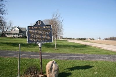
General Anthony Wayne and the Legion of the United States passed this way on October 30, 1794, in route from Fort Wayne to Fort Greenville, ending the western campaign against the Indian Confederacy. The Legion spent the previous night camped 2.6 . . . — — Map (db m29620) HM
Adams County formed 1835. Geneva incorporation 1874 included early towns Alexander and Buffalo. During 1890s oil boom, population and businesses grew. Fire destroyed much of town 1895; Geneva Board of Trustees banned wooden buildings, mandated . . . — — Map (db m63824) HM
Colonel Hugh B. Reed served as first Commandant. Here the 30th, 44th, 74th, 88th, and 100th Indiana Regiments and the 11th Indiana Battery were organized. — — Map (db m215667) HM
On February 22, 1832, ground was broken two blocks north for the canal, which would link Lake Erie at Toledo with the Ohio River at Evansville. Jordan Vigus, Canal Commissioner, Charles W. Ewing, Samuel Hanna, Elias Murray participated in the . . . — — Map (db m21045) HM
Home 1948-1967 of Farnsworth, inventor of television. Farnsworth (1906-1971) was instrumental in perfecting the image formation mechanism which enabled the first effective image transmission in 1927. Farnsworth Radio and Television Corporation in . . . — — Map (db m65186) HM
French built a palisaded fort on this strategic site in 1722; named Fort Saint Philippe des Miamis. One of three French forts built in what is now Indiana to protect French fur trade from encroaching English. First of five forts built over time . . . — — Map (db m241261) HM
Colonel John Hardin, of the Kentucky Militia, with 180 men and Captain John Armstrong, U.S. Army, with 30 men, were routed here on October 19, 1790, by Indians under Miami Chief Little Turtle during General Harmar's Campaign. — — Map (db m232339) HM
Wabash and Erie Canal lock was discovered here June 1991 during excavation for highway construction. It was built 1838–1840 by Henry Lotz and named for lock keeper Joseph Gronauer. The rare, well-preserved timber-frame design lock measured . . . — — Map (db m2498) HM
(Front Side)
Construction begun summer 1942 under Captain Stratton O. Hammon, who used broad authority over laborers, suppliers, and railroad; base in use February 1943. More than 1,000 workers employed during construction. Base was over . . . — — Map (db m63819) HM
County formed by Indiana General Assembly 1821. Thirty acres of land were purchased, and John Tipton donated thirty acres, for county seat. State commissioners named county seat Tiptona — after Tipton; local elected commissioners renamed it . . . — — Map (db m48105) HM
In late 1800’s railroads and new technology opened national markets to Midwest producers, including Indiana, a leader in corn products. Joseph Gent patented operations and devices to mass-produce flaked corn. Gaff, Gent, & Thomas Co. Began making . . . — — Map (db m238476) HM
From 1830 to 1880 the community of Lowell Mills thrived here along Driftwood River. There were two grist mills, a cooperage, a shoemaker's shop, a distillery, a saw mill, a woolen mill, an inn and general store. When the mills closed, the town was . . . — — Map (db m63794) HM
(Front Side)
Incorporated and its factory built here 1890. Reorganized 1891; William H. Lincoln then led the company to great success, stressing quality and artistic merit in fine, high-grade furniture. By 1895, production included . . . — — Map (db m63818) HM
Congregation was formed in 1879; reorganization in 1882 by the Reverend John R. Miller and a core of determined members. The present building, formerly a theater, was acquired in 1913. This African-American church, like many others, has served its . . . — — Map (db m63815) HM
Mandated by Indiana's 1836 Internal Improvement Act, construction began in Madison 1836. Completed along this site 1843; Elizabethtown platted 1845 as a result of the railroad. Completed to Indianapolis in 1847. Linked Ohio River and interior of . . . — — Map (db m63798) HM
Original site of coeducational United Brethren school founded 1850 as Hartsville Academy by public act of Indiana General Assembly. Campus moved four blocks south, circa 1865; destroyed by fire, January 1898. Many graduates became distinguished . . . — — Map (db m63805) HM
Mitchell, Co. F, 27th Indiana Volunteers, is buried in
Hartsville Baptist Cemetery. He found Confederate General
Lee's "Lost" Special Orders No. 191 near Frederick, MD, September 13, 1862. Union General McClellan then engaged Lee at the Battle . . . — — Map (db m63806) HM
Benton County formed by General Assembly in 1840. Oxford first county seat; Fowler became second, 1874. Designed in Second Empire Style by Gorden P. Randall and built 1874 by Levi L. Leach. Located at geographical center of county on land donated by . . . — — Map (db m21487) HM
In October 1818, Purchasing Commissioners Lewis Cass, Benjamin Parke and Governor Jonathan Jennings acquired Indian claims on the land shown on this marker. About one-third of modern Indiana, was involved in this transaction. — — Map (db m21517) HM
Side One
Standard-bred colt (sire Joe Patchen, dam Zelica) foaled 1896 Oxford, Benton County; raised by Daniel A. Messner, Jr. on this farm. A natural pacer, trained for harness racing, a very popular sport in late 1800's and early 1900's. . . . — — Map (db m8546) HM
Blackford County's second courthouse, featuring a 165 foot high clock tower, was built on foundation stones from nearby Montpelier quarries. At a cost of $129,337.83, this Richardsonian Romanesque structure was constructed 1893-1895. Listed in . . . — — Map (db m41465) HM
In 1920, a small group of women in Hartford City founded Sigma Phi Gamma, a non-scholastic sorority dedicated to friendship and philanthropy. The sorority expanded across Indiana, the U.S., and into Canada by 1929. To fulfill its mission of service, . . . — — Map (db m231195) HM
Reserved by U.S. to Chief Francois Godfroy of the Miami Nation of Indians by treaty at St. Mary's, Ohio, 6 October 1818, 3,840 acres on Salamonie River at La Petite Prairie, Harrison Township, Blackford County; reserve lands sold 1827, 1836. — — Map (db m63825) HM
Prominent educator and statesman Herman B. Wells was born in Jamestown, Indiana. During the Great Depression, he directed research for the Indiana Bank Commission, producing state banking reforms. In 1938, Wells was elected President of Indiana . . . — — Map (db m175678) HM
A progressive politician and lifelong Democrat, Ralston met the challenges posed by Indiana’s transition to a more urban and industrial state. Born 1857 in Ohio, he opened a law office in 1886 in Lebanon, where he lived until elected governor in . . . — — Map (db m175673) HM
The Boone County REMC built Indiana's first electric cooperative line to the Clark Woody farm 5 miles west of this site with funds borrowed from the Rural Electrification Administration, July 22, 1935. — — Map (db m27673) HM
Ka-wi-a-ki-un-gi Village "Place of Thorns" (Thorntown) was center of 64,000 acre Thorntown Indian Reserve. Granted to Eel River Miamis in 1818, ceded to U.S. in 1828. — — Map (db m21352) HM
With proceeds from the sale of 170,580 acres of Indian land granted by the Federal Government, Indiana built its first north-south road. Surveyed 1829, passable by 1834, "completed" in 1837, its cost was $242,000.00. — — Map (db m67191) HM
Patrick H. Sullivan, 1794-1879, was the first white settler in Boone County, 1823, and built the first log cabin. In 1857, he bought this site and lived here until 1872. He served in the War of 1812. — — Map (db m67190) HM
Theodore Clement Steele (1847-1926) lived and painted south of here, 1907-1926. Member of Hoosier Group of American impressionists, his landscape paintings captured picturesque panoramas characteristic of area. Property is State Historic Site; . . . — — Map (db m242256) HM
Fouts Soyland Farm. Influenced by experiments conducted in the 1890s by Purdue University and Indiana farmers like his father Solomon, Carroll County farmer Taylor Fouts was growing soybeans by 1904. With his brothers Noah and Finis, Fouts . . . — — Map (db m238477) HM
In October 1818, Purchasing Commissioners Lewis Cass, Benjamin Parke and Governor Johnathan Jennings acquired Indian claims on the land shown on this marker. About one-third of modern Indiana was involved in this transaction. — — Map (db m1152) HM
Constructed 1832-1853, canal was
nation's longest, connecting Lake
Erie at Toledo with Ohio River at
Evansville. Key portion in Carroll
County included Deer Creek Lake
Dam, constructed 1838-1840 (1 mile
west). Various canal structures . . . — — Map (db m163353) HM
Constructed 1832-1853, canal was nation's longest, connecting Lake Erie at Toledo with Ohio River at Evansville. Key portion in Carroll County included Deer Creek Lake Dam, constructed 1838-1840 (1 mile west). Various canal structures are still in . . . — — Map (db m7540) HM
This row of sycamores sprouted from freshly cut logs used in the 1830's to corduroy a swampy section of the historic Michigan Road, the first state road in Indiana, running from Madison to Michigan City. — — Map (db m201386) HM
Trade and emigration route from Lake Erie to Evansville. Completed through Logansport 1840. Followed Erie Avenue and 5th Street, crossing Eel River by wooden aqueduct. Abandoned about 1876. — — Map (db m35409) HM
Coeducational school founded 1884 by William W. Borden primarily to serve children of southern Indiana farmers. Low-cost, progressive program included teacher preparation and laboratory-based scientific studies. School closed 1906. Borden also . . . — — Map (db m74115) HM
Nearby is site of former popular Ohio River regional recreation area known from 1880s as Fern Grove. David Rose expanded facilities in 1923 – including an amusement park and a swimming pool – and named it Rose Island. Major access was by car to . . . — — Map (db m206818) HM
Indiana Territorial Delegate to
Congress, 1809-1816.
President of Indiana Constitutional
Convention, June, 1816.
First Governor of Indiana, 1816-1822.
Member of Congress, 1822-1830. — — Map (db m206887) HM
John Work, born 1760 in Pennsylvania, came with family to Clark County, Indiana Territory circa 1804. He purchased land along Fourteen Mile Creek in 1805 and later acquired extensive property in the county. Federal-style brick home here built circa . . . — — Map (db m206815) HM
Women’s rights activist and political strategist Mary Garrett Hay was born in Charlestown. She worked with the WCTU here and in Indianapolis in the late 1800s, honing her leadership and speaking skills and advancing women’s suffrage. Susan B. . . . — — Map (db m206885) HM
Near this site on October 26, 1803, Meriwether Lewis and William Clark with the nucleus of the Corps of Discovery together set off down the Ohio River on their epic journey to explore the Louisiana Purchase and Pacific Northwest. — — Map (db m206962) HM
Founder of Kentucky Fried Chicken
Erected 1987 by these Local Franchisees:
Mr. & Mrs. Robert Bagshaw
Mr. & Mrs. William Bridges
Mr. & Mrs. William Bright
Mr. & Mrs. Roy Burchel
Mr. & Mrs. Lee Cummings
Mr. & Mrs. Ralph . . . — — Map (db m245085) HM
Indiana's oldest state forest, established 1903. Portions of Clark's Grant (1781) included in original 2.000 acres. Experimental plantings and reforestation began 1904; became national models in scientific forestry. Multiple land uses include timber . . . — — Map (db m244937) HM
Site of Jefferson General Hospital, the third largest hospital in the United States during the Civil War. Under Dr. Middleton Goldsmith's command it served over 16, 000 patients. — — Map (db m46647) HM
Emancipation Proclamation (1863) did not free slaves in Kentucky. In April 1864, Hannah Toliver, a free black woman living in Jeffersonville, was arrested for aiding a fugitive slave from Kentucky. In May, she was convicted and sentenced to seven . . . — — Map (db m100710) HM
County formed by Indiana General Assembly 1825; named for national statesman Henry Clay. First county seat at Bowling Green; had three courthouses: first built 1827 was two-story log structure; second and third built 1839-1840 and 1852-1853 were . . . — — Map (db m18883) HM
Jimmy Hoffa was born in Brazil, Indiana in 1913. His family struggled with poverty, inspiring him to become an organized labor leader during the Great Depression. He became active in the International Brotherhood of Teamsters in the 1930s and served . . . — — Map (db m238479) HM
Hall of Famer Everett Case, known for his basketball strategies and promotion of the sport, began his high school coaching career at age 19. After stints at Columbus and Smithville, he coached Frankfort for 17 seasons starting in 1922. He led his . . . — — Map (db m238480) HM
Chert and aragonite were mined prehistorically. Land containing Wyandotte and Saltpeter Caves was purchased by Levi Brashear on September 30, 1810 for saltpeter mining and by Dr. Benjamin Adams on December 27, 1815 for epsomite mining. — — Map (db m207097) HM
Founded 1818 by Seth and Zebulon Leavenworth. Ohio River port for keelboats, flatboats, packets. Shipped pork, spirits, produce, corn, lumber, etc. Manufactured skiffs, flatboats, pearl buttons. Crawford County seat, 1843-c. 1895, when "stolen" by . . . — — Map (db m207137) HM
A canal from Terre Haute to Evansville authorized 1846. Maysville Division along White River was over 23 miles long from Newberry through Owl Prairie (now Elnora) to Maysville; part of it paralleled what is now S.R. 57. Contracts were let June . . . — — Map (db m23203) HM
Platted in 1846 by John Hastings; town named Clarksburg reportedly after George Rogers Clark; post office name was Clark’s Prairie, 1858-1881. Both names changed to Odon, 1881; Odon incorporated, 1885. By tradition, name Odon coined by combining . . . — — Map (db m99006) HM
Mission Revival Style depot, built 1906, restored 1990; part of Washington Commercial Historic District. Link to city's trading and industrial history, with substantial railroad machine shops and car works. Indiana stop of former President Dwight D. . . . — — Map (db m23214) HM
Built on this site by civilians to protect approximately ten families during War of 1812. Named for landowner David Flora. Ten such forts were built circa 1811-1813 in area that became Daviess County. Area was Knox County, part of Indiana Territory . . . — — Map (db m23211) HM
Side A
Homer E. Capehart
Born into Indiana farming family 1897. Manufactured and pioneered sales of automatic phonographs, creating Capehart Corporation. Executive of Rudolph Wurlitzer Company 1933-1944. Organized 1938 Republican . . . — — Map (db m23206) HM
Residence of Robert C. Graham (1885-1967), pioneer glass, truck and auto manufacturer. Placed on the National Register of Historic Places in 1983 by the U.S. Department of the Interior because of its history and Prairie Style architecture. — — Map (db m23208) HM
Robert Cabel Graham (1885-1967), a native of Washington, Daviess County, with his brothers Joseph and Ray, contributed much to the economy and quality of life in that city, Evansville, and other towns. Glass factories, truck manufacturing, and . . . — — Map (db m98936) HM
In 1788 Congress granted 400 acres of land to each French family of this area. The tract was laid off in a square containing 160 separate plots. Additional grants were made affecting the five counties shown. — — Map (db m98935) HM
(Front Side)
The Whitewater Canal and the Cincinnati and Whitewater Canal joined in Harrison to provide better access to Cincinnati markets and Ohio River. Indiana Internal Improvement Act 1836 authorized Whitewater Canal; completed from . . . — — Map (db m66869) HM
Side one
Wilder (1830-1917), resident of Greensburg circa 1858-1869, built this home 1865-1866. He was millwright and inventor; provided major employment in the area. Enlisted in Civil War; appointed lieutenant colonel of Seventeenth . . . — — Map (db m44744) HM
Site of the original court house built in 1827 and occupied until 1854. Present building completed in 1860. Large tooth aspen tree appeared in 1870 on the roof of the 115 foot clock tower. In July, 1863, it became a temporary armory while troops . . . — — Map (db m44757) HM
Side one:
Luther Donnell was convicted in Decatur Circuit Court (1849) of aiding fugitive slaves, Caroline and her four children, to escape to Canada. In Donnell v. State, Indiana Supreme Court reversed the conviction, claiming that under . . . — — Map (db m44752) HM
Caroline and her four children escaped Kentucky slave owner October 31, 1847; they crossed Ohio River near Madison. After passing near here, Fugit Township black and white residents hid family close to Clarksburg. While hidden, family seized . . . — — Map (db m44743) HM
Auburn Automobile Company (1900-1937) Art Deco Style Administration building, built 1929-1930. Housed departments of Cord Corporation, manufacturer of Auburn, Cord, and Duesenberg automobiles. Became Auburn-Cord-Duesenberg Museum, 1974; listed in . . . — — Map (db m53934) HM
Humorist, author, and critic Will Cuppy
was born here. He graduated from the
University of Chicago, where he
published his first book in 1910. He
moved to New York City ca. 1914 and
become a book reviewer at the New York
Herald . . . — — Map (db m238481) HM
Stage performer and silent film actor John Bowersox grew up along Cowen Street. He performed in amateur plays in Huntington and in 1904 joined a professional touring
company. Adopting the stage name Bowers, he debuted on Broadway in 1912 and . . . — — Map (db m238482) HM
Side One
Ralph and Anne Sechler established Sechler’s Pickles (first named St. Joe Valley) on their homestead here in the 1920s. Despite the Great Depression, they grew the business, selling many varieties of pickles to local restaurants . . . — — Map (db m241165) HM
Built 1873, by John A. McKay, spanning Saint Joseph River; a Smith Truss, Variant Four, by Smith Bridge Company, Toledo, Ohio; has remained in use with regular maintenance, repairs, and extensive 1981 restoration. Listed in National Register of . . . — — Map (db m52971) HM
Side 1
Ornithologist Jane L. Hine was born
in Ohio and graduated from Oberlin
College before moving to DeKalb
County. She raised a large family,
starting ornithological work later in
life by studying the birds near her
Sedan farm. . . . — — Map (db m241163) HM
The first significant commercial gas well came in Sept. 15, 1886, near here south of the Mississinewa River and East of the railroad, ushering in the gas boom era. Almeron H. Crannell, a Civil War veteran and later resident of Hartford City, drilled . . . — — Map (db m63797) HM
Site of production mill and three beehive kilns, first fueled by wood and then by natural gas, circa 1883-1910, owned & operated by Manassa Myers, Sr. family. Produced drainage tiles (hollow cylinder-shaped sections) from adjacent clay pit for local . . . — — Map (db m63796) HM
Company incorporated in New York 1886 to manufacture glassware (particularly fruit jars). Brothers Edmund, Frank, George, William, and Lucius Ball all were trustees. Company - promised money, land, and free natural gas - came to Muncie; first . . . — — Map (db m31345) HM
To meet Muncie’s higher education needs, the Ball Brothers gave land, money, and the building here to the state in 1918. Their gift became the Indiana State Normal School Eastern Division and was renamed Ball Teachers College in their honor in 1922. . . . — — Map (db m231197) HM
Side A
Founded as Gray & Hemingray in
Cincinnati, Ohio in 1848. Incorporated
1870 in Covington, Kentucky; company
produced glass bottles, jars, oil
lamps, light globes, tableware and
insulators. After discovery of natural
gas in . . . — — Map (db m65208) HM
Structure, circa 1893, is Muncie's oldest standing public school building. Purchased by church congregation, circa 1928. Rallying point in August 1930 when bodies of two African-American men, lynched in Marion, were brought to Muncie for embalmment . . . — — Map (db m31346) HM
Increased crime during the Great Depression demanded an expanded police presence and faster communication technology. In response, the Motor Vehicle Police (established in 1921) was reorganized as the Indiana State Police in 1933. The new division . . . — — Map (db m238483) HM
Side One:
In 1847, three Kentucky men tried to capture Thomas Harris, fugitive slave in Bristol; a justice of the peace ruling freed Harris, who fled. In 1848, the Elkhart Circuit Court convicted the three men of causing a riot in 1847. In . . . — — Map (db m30744) HM
Born in Ohio 1842; family moved to Kosciusko County, Indiana 1846. Bierce lived and worked in Elkhart 1860-1861. Union officer wounded in Civil War. Moved to California 1866; became nationally prominent as journalist, short story writer, and critic. . . . — — Map (db m44852) HM
Side One:
Charles Gerard Conn began the musical instrument industry in Elkhart; city has been called the Band Industry Capital of the World. By 1874 producing rubber mouthpiece; was granted patent 1875; began producing musical . . . — — Map (db m30747) HM
Born in Ohio, 1925, Gordone grew up in Elkhart and graduated from Elkhart High School in 1944. In the 1950s, he moved to New York City where he worked as an actor, director, and playwright. During the 1960s, he acted in the award-winning . . . — — Map (db m32734) HM
Side one:
Born circa 1845 in Ohio. Graduated from Rush Medical College 1874. Moved medical practice from Chicago to Elkhart 1875. Began The Dr. Miles Medical Company 1885 to sell Dr. Miles' Nervine, Restorative Nerve and Liver pills, and . . . — — Map (db m44877) HM
(Side one):
Added many buildings to the architectural significance of Elkhart, Goshen, and Nappanee. Born mid-1850s in England; his family moved to Elkhart early 1870s. In mid-1880s he moved to Chicago; worked until 1890 with architect . . . — — Map (db m32728) HM
Amos E. Kunderd (1866 - 1965) owned and resided on a 100-acre farm on this site. Respected internationally for hybridization of varieties of gladioli which were exhibited, and grown in gardens, throughout the world. Originated the ruffled and . . . — — Map (db m30161) HM
Elkhart County was formed by the Indiana General Assembly 1830; the first county seat was located in Concord Township. County commissioners relocated the county seat to Goshen 1831. Jacob Studebaker, Goshen, designed first brick courthouse, . . . — — Map (db m30157) HM
Indiana's first Carnegie library opened here 1903 with 3, 000 volumes. Goshen Library Association received $25, 000 in Carnegie grants 1901. Public donations, land purchase, and tax levy met Carnegie grant conditions. Architects Patton & Miller, . . . — — Map (db m32724) HM
Born 1896 in house on this site into locally prominent family. Moved with parents to Neenah, Wisconsin 1899 and to Pasadena, California 1906. Hawks - director, producer, screenwriter - is recognized as one of Hollywood's greatest filmmakers. His . . . — — Map (db m30407) HM
The boundary between Indiana and Michigan territories was established in 1805. Just before Indiana became a state in 1816, the line was moved ten miles north to give Indiana frontage on Lake Michigan. — — Map (db m44849) HM
Side One:
Krider Nurseries constructed and exhibited Krider's Diversified Garden at Century of Progress International Exposition in Chicago 1933-1934. Some plants and structures were returned to Middlebury, and garden was reconstructed . . . — — Map (db m30745) HM
(Side one):
Merrill Blosser was first Nappanee artist to gain national recognition as a professional cartoonist. Freckles and His Friends, his most popular cartoon, ran from 1915 to 1973, syndicated by Newspaper Enterprise Association. In . . . — — Map (db m31478) HM
Side one:
Nappanee platted 1874 on Baltimore & Ohio Railroad line. Sawmill opened 1873 produced ties for railroad construction. Coppes and Mutschler brothers were partners in lumber, milling, and furniture business, 1902-1913, becoming . . . — — Map (db m62666) HM
In 1836 construction began on this fifty-six lock, one hundred one mile canal. Opened from Lawrenceburg to Brookville (1839), it was extended to Laurel and Cincinnati (1843), Connersville (1845), Cambridge City (1846), and Hagerstown (1847). — — Map (db m44741) HM
Justice Sherman Minton was born in Georgetown and attended New Albany High School. After graduating from law school, he served overseas during WWI. In 1934, he was elected to the U.S. Senate as a New Deal Democrat. Nominated by President Roosevelt, . . . — — Map (db m207055) HM
As early as 1821, enslaved blacks seeking freedom crossed the Ohio River from Louisville to New Albany. Antebellum and Civil War periods brought more fugitives. Many freedom-seekers were aided by other slaves, free blacks, and anti-slavery whites -- . . . — — Map (db m30841) HM
American Bison, migrating in great herds, created a cluster of paths along the natural topography between Illinois prairies and salt licks in Kentucky. These paths, called the Buffalo Trace, used by Native Americans and became premier travel route . . . — — Map (db m71282) HM
Born in New Albany 1892. Was ordained 1917 after graduation from St. Meinrad College and Seminary and assigned to his first parish in Indianapolis. He advanced in the church, becoming Bishop of Indianapolis 1934 and first Archbishop of new . . . — — Map (db m209410) HM
Grant Line Road marks the western boundary of the 150,000 acres of land granted in 1781 by Virginia to General George Rogers Clark and his officers and soldiers who fought to reduce the British presence in Illinois Country during the Revolutionary . . . — — Map (db m206983) HM
French Second Empire Style structure. Construction began 1867 for William Stewart Culbertson (1814-1892), leading industrialist, financier, and philanthropist in New Albany area. Listed in National Register of Historic Places, 1974; accepted as . . . — — Map (db m180500) HM
[side 1] William S. Culbertson, wealthy merchant, opened home November 18, 1873 to provide food, clothing, and shelter for town's destitute widows. Home had gas lighting, upstairs water closet, and up-to-date kitchen. Residents' lives were . . . — — Map (db m180503) HM
Side 'One'
Because of the growing number of African-American school-age children, the New Albany School Board authorized a new elementary school for them June 1884. It opened here 1885. An 1869 Indiana law had mandated education of colored . . . — — Map (db m46620) HM
587 entries matched your criteria. The first 100 are listed above. Next 100 ⊳