96 entries match your criteria.
Great Lakes Seaway Trail National Scenic Byway Historical Markers
Great Lakes Seaway Trail, Inc. markers along 500 miles of the St. Lawrence River, Lake Ontario, and Lake Erie, from Massena NY to the PA-OH border.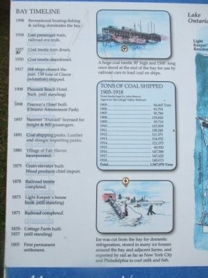
By Anton Schwarzmueller, November 7, 2014
Left Detail
| 1 ► New York, Cayuga County, Fair Haven — Little Sodus Bay (Fair Haven) — A Busy Lakeport — Maritime Heritage — |
| On Bell Avenue, 0.1 miles north of Main Street (New York State Route 104A). | |||
| 2 ► New York, Chautauqua County, Dunkirk — Birds of the Harbor — Water Bird Safe Haven — Natural History — |
| On Central Avenue, 0.1 miles north of Lake Shore Drive West (New York State Route 5), on the left when traveling north. | |||
| 3 ► New York, Chautauqua County, Dunkirk — Dunkirk Lighthouse — |
| Near Point Drive North, 0.6 miles north of Lake Shore Drive West (New York State Route 5). | |||
| 4 ► New York, Chautauqua County, Dunkirk — Eastern Basin Shipwrecks — A Watery Record of Mishaps — Maritime Heritage — |
| On Central Avenue, 0.1 miles north of Lake Shore Drive West (New York State Route 5), on the left when traveling north. | |||
| 5 ► New York, Chautauqua County, Mayville — Mayville Station — A Transportation Hub — History of the Coast — |
| On Water Street (New York State Route 394) 0.2 miles south of Lakeview Avenue, on the left when traveling south. | |||
| 6 ► New York, Chautauqua County, Pomfret — Lily Dale Assembly — Spiritualism's Largest Community — Cultural Heritage — |
| On Glasgow Road (County Route 48) at Dale Drive (County Route 48), on the left when traveling east on Glasgow Road. | |||
| 7 ► New York, Chautauqua County, Westfield — Barcelona Harbor — Invasion Route Shipping Port, Fishing Center — History of the Coast — |
| On East Lake Road (New York State Route 5) 0.2 miles east of North Portage Road (New York State Route 394), on the right when traveling west. | |||
| 8 ► New York, Chautauqua County, Westfield — The French & Indian War 1756-1763 — A Fight for the Continent — French and Indian War — |
| On East Lake Road (New York State Route 5) east of North Portage Road (New York State Route 394), on the left when traveling east. | |||
| 9 ► New York, Erie County, Buffalo, Albright — Frederick Law Olmsted — Landscape Architect — People of the Coast Famous designers left footprints along the Seaway Trail. — |
| On Rumsey Road north of Forest Avenue, on the right when traveling north. | |||
| 10 ► New York, Erie County, Buffalo, Delaware Park — Buffalo Zoo — Growing with the City — |
| On Parkside Avenue at Jewett Parkway, on the right when traveling south on Parkside Avenue. | |||
| 11 ► New York, Erie County, Buffalo, Downtown — Buffalo Burns!!! — British Forces Torch the Frontier — War of 1812 — |
| Near Niagara Square at Niagara Street. | |||
| 12 ► New York, Erie County, Buffalo, First Ward — Buffalo Main & Harbor Lights — |
| Near Fuhrmann Boulevard, 1.3 miles north of The Skyway (New York State Route 5). | |||
| 13 ► New York, Erie County, Buffalo, Park Meadow — Buffalo's Olmsted Parks — A System of Parks & Parkways — Architecture of the Coast — |
| On Nottingham Terrace at Lincoln Parkway, on the right when traveling east on Nottingham Terrace. | |||
| 14 ► New York, Erie County, Buffalo, Park Meadow — Highlights of Buffalo History — Buffalo and Erie County Historical Society — Cultural Heritage — |
| On Museum Court at Nottingham Terrace, on the left when traveling south on Museum Court. | |||
| 15 ► New York, Erie County, Buffalo, Tifft — Tifft Nature Preserve — An Urban Sanctuary — Natural History — |
| Near Fuhrmann Boulevard, 0.2 miles north of Tifft Street. | |||
| 16 ► New York, Erie County, Buffalo, Waterfront — The Industrial Heritage Trail — Monuments to the Movement of Grain — Maritime Heritage — |
| Near Erie Street, 0.1 miles west of Marine Drive. | |||
| 17 ► New York, Erie County, Evans — Graycliff — A Frank Lloyd Wright Masterwork — Architecture of the Coast — |
| On Old Lakeshore Road, 0.1 miles west of South Creek Road, on the right when traveling west. | |||
| 18 ► New York, Erie County, Evans — The White City — William J. Conners Poultry Farm — History of the Coast — |
| On Old Lakeshore Road at Iroquois Street, on the left when traveling west on Old Lakeshore Road. | |||
| 19 ► New York, Erie County, Hamburg — Lake Erie — Sailing Through Time — Maritime Heritage — |
| On Lake Shore Road (New York State Route 5) 0.1 miles west of Lakewood Avenue, on the right when traveling west. | |||
| 20 ► New York, Franklin County, Akwesasne — Akwesasne (AH kwey ZAH sney) — An Enduring Native Culture — |
| Near New York State Route 37 at Library Road. | |||
| 21 ► New York, Jefferson County, Alexandria — Indian River Lakes — Breeding Bird Refuge — Natural History — |
| On New York State Route 37 at milepost 22.3,, 0.1 miles south of Stine Road, on the left when traveling north. | |||
| 22 ► New York, Jefferson County, Clayton — Clayton Opera House — A Thousand Islands Cultural Center — Cultural Heritage |
| On Riverside Drive at Merrick Street, on the right when traveling east on Riverside Drive. Reported missing. | |||
| 23 ► New York, Jefferson County, Clayton — Eagle Wing Group — An Underwater Geological Wonder — Dive Sites of the St. Lawrence — |
| On Riverside Drive west of Merrick Street, on the right when traveling west. | |||
| 24 ► New York, Jefferson County, Ellisburg — The Battle of Big Sandy — May 30, 1814 — War of 1812 — |
| Near New York State Route 3 north of Nash Road, on the left when traveling north. | |||
| 25 ► New York, Jefferson County, Sackets Harbor — Fort Pike — Defending the Harbor — |
| On Pike Road at Backus Road, on the right when traveling west on Pike Road. | |||
| 26 ► New York, Jefferson County, Sackets Harbor — Sackets Harbor — Built on War of 1812 Heritage — Maritime Heritage — |
| On West Main Street (County Route 62) west of Bayard Street, on the left when traveling west. | |||
| 27 ► New York, Jefferson County, Sackets Harbor — Sackets Harbor - Fall 1814 — A Fortified Naval Base — War of 1812 — |
| On West Main Street (County Route 62) at Abrose Street, on the left when traveling west on West Main Street. | |||
| 28 ► New York, Jefferson County, Sackets Harbor — Sackets Harbor Shipbuilding — A Race for Naval Superiority — Maritime Heritage — |
| On West Main Street (County Route 62) near Bayard Street, on the right when traveling west. | |||
| 29 ► New York, Monroe County, Greece — Bird Migration Research — Long Term Migratory Bird Data — Natural History — |
| On Manitou Beach Road (New York State Route 261) 0.1 miles south of Braddocks Avenue, on the right when traveling east. | |||
| 30 ► New York, Monroe County, Greece — Braddock Bay Hawk Watch — Following the Curve of the Shore — Natural History — |
| Near Braddock Bay State Parkway, 0.2 miles north of East Manitou Road (County Route 140). | |||
| 31 ► New York, Monroe County, Greece — Converge on Montreal — The British Plan — French & Indian War — |
| On Braddock Bay State Parkway, 0.2 miles north of East Manitou Road (County Route 140), on the right when traveling east. | |||
| 32 ► New York, Monroe County, Irondequoit, East Irondequoit — British Army Encampment — Prideaux's Campaign — French & Indian War — |
| On Culver Road (County Route 120) 0.2 miles east of Sea Breeze drive, on the left when traveling east. | |||
| 33 ► New York, Monroe County, Rochester — Susan B. Anthony House — Headquarters of the Suffrage Movement — |
| On Madison Street, 0.2 miles north of West Main Street (New York State Route 33). | |||
| 34 ► New York, Monroe County, Rochester, Charlotte — Charlotte-Genesee Lighthouse — |
| Near Lighthouse Street, 0.1 miles north of Latta Road. | |||
| 35 ► New York, Monroe County, Rochester, Charlotte — Merchant Ship to Warship — Schooner-Gunboats in the U.S. Navy — War of 1812 — |
| Near Lake Avenue near Corrigan Street. | |||
| 36 ► New York, Monroe County, Rochester, Downtown — Margaret Woodbury Strong — Collector Extraordinaire — People of the Coast — |
| Near Pitkin Street, 0.2 miles south of East Broad Street. | |||
| 37 ► New York, Monroe County, Webster — Irondequoit Bay — Gateway to the Continent — Maritime History — |
| Near Empire Boulevard (New York State Route 404) 0.8 miles east of Winton Road, on the left when traveling east. | |||
| 38 ► New York, Niagara County, Lewiston — Fighting for Homeland — American Indian Allies — New York State French & Indian War Commemoration - 250 Years — |
| Near Lewiston Road (New York State Route 104) 0.2 miles north of Hyde Park Boulevard (New York State Route 61). | |||
| 39 ► New York, Niagara County, Lewiston — The Battle of Queenston Heights — First Battle of the War — War of 1812 — |
| On Center Street west of North Water Street, on the right when traveling west. | |||
| 40 ► New York, Niagara County, Lewiston — Tuscaroras Defend Lewiston Against 1813 British Attack — War of 1812 — |
| On Portage Road at Center Street (New York State Route 18F), on the right when traveling south on Portage Road. | |||
| 41 ► New York, Niagara County, Newfane — McClew Farm — An Underground Railroad Safe House — Cultural Heritage - Routes to freedom passed through many Seaway Trail communities — |
| Near McClew Road, 0.6 miles north of Ide Road. | |||
| 42 ► New York, Niagara County, Newfane — Olcott Beach — A Lakeside Resort — |
| On Franklin Street at East Main Street, on the right when traveling north on Franklin Street. | |||
| 43 ► New York, Niagara County, Niagara Falls — Fort Schlosser — Guarding the Upper Landing — |
| Near Niagara Scenic Parkway (New York State Route 957A) 1 mile west of Interstate 190, on the left when traveling north. | |||
| 44 ► New York, Niagara County, Niagara Falls — Portage Road — Carry Route Around the Falls — Cultural Heritage — |
| On Portage Road south of Pine Avenue (U.S. 62), on the right when traveling north. | |||
| 45 ► New York, Niagara County, Niagara Falls — The Great Cataract of Niagara — An attraction even in wartime — |
| Near Niagara Scenic Parkway (New York State Route 957A) 1 mile north of Interstate 190. | |||
| 46 ► New York, Niagara County, North Tonawanda — Once Around is Never Enough — Carousels and More — |
| On Thompson Street at Vandervoort Street, on the left when traveling east on Thompson Street. | |||
| 47 ► New York, Niagara County, Somerset — 30 Mile Point Lighthouse — |
| 48 ► New York, Niagara County, Somerset — Horsepower — Working the Turn-of-the-Century Farm — Culture of the Coast — |
| On Lake Road (New York State Route 18) 0.2 miles west of Hosmer Road (County Route 65), on the right when traveling west. | |||
| 49 ► New York, Niagara County, Wilson — Lake Shore Rarities — Year 'Round Birding Possibilities — Natural History — |
| On Wilson-Tuscarora State Park Road, 0.2 miles north of Lake Road (New York State Route 18), on the right when traveling east. | |||
| 50 ► New York, Niagara County, Wilson — Wilson Harbor — Boards, Boats, and Beaches — |
| On Ontario Street, on the left when traveling west. | |||
| 51 ► New York, Niagara County, Youngstown — Old Fort Niagara Lighthouse — |
| On Scott Avenue north of Jackson Street (New York State Route 18F), on the left when traveling north. | |||
| 52 ► New York, Niagara County, Youngstown — The Battle of La Belle Famille — French Losses: The Battle & The Interior — |
| On Main Street (New York State Route 18F) north of Lockport Road (New York State Route 93), on the left when traveling north. | |||
| 53 ► New York, Niagara County, Youngstown — The Siege of Fort Niagara — A Calculated Attack — |
| On Scott Avenue north of Jackson Street (Route 18F), on the right when traveling north. | |||
| 54 ► New York, Orleans County, Carlton — Cobblestone Wall Section — Cobblestone Construction Piece by Piece — Architecture of the Coast — |
| On Point Breeze Road (New York State Route 98) at Lake Ontario Parkway, on the left when traveling north on Point Breeze Road. | |||
| 55 ► New York, Orleans County, Carlton — Fishing Camp — A Prehistoric Destination — Maritime Heritage — |
| Near Ontario Street, 0.1 miles north of Water Street. | |||
| 56 ► New York, Orleans County, Carlton — Sir William Johnson — Leader and Diplomat — The French and Indian War — |
| Near Lake Road (New York State Route 18) 0.2 miles north of Lake Ontario Parkway. | |||
| 57 ► New York, Orleans County, Gaines — Cobblestones — Birth of a Local Style — Architecture of the Coast — |
| On Ridge Road West (New York State Route 104) at Oak Orchard Road (New York State Route 98), on the right when traveling west on Ridge Road West. | |||
| 58 ► New York, Oswego County, Oswego — Age of Iron Horses — The Railroad Arrives — |
| On East 1st Street (New York State Route 481) north of East Mohawk Street, on the right when traveling south. | |||
| 59 ► New York, Oswego County, Oswego — British Invasion — The Battle of Oswego — War of 1812 — |
| On E 4th Street. | |||
| 60 ► New York, Oswego County, Oswego — Early Shipping — A Natural Port for Commerce and Conflict — |
| On East 1st Street (New York State Route 481) north of East Mohawk Street, on the right when traveling south. | |||
| 61 ► New York, Oswego County, Oswego — Open Water = Winter Birds — Ducks, Gulls, and Predators — Natural History — |
| On Lake Street at Montcalm Street, on the left when traveling east on Lake Street. | |||
| 62 ► New York, Oswego County, Oswego — Oswego West Side Forts — An Early French Target — French and Indian War — |
| On Lake Street at Montcalm Street, on the left when traveling east on Lake Street. | |||
| 63 ► New York, Oswego County, Oswego — People of the River — The People Who Led the Way — |
| On East 1st Street (New York State Route 481) north of East Mohawk Street, on the right when traveling south. | |||
| 64 ► New York, Oswego County, Oswego — Prideaux's Campaign — A Long Route to Victory — French and Indian War — |
| On East 4th Street north of Show Park Road, on the left when traveling north. | |||
| 65 ► New York, Oswego County, Oswego — Richardson - Bates House Museum — A Victorian Showcase — Pursuit of Culture — |
| On East 3rd Street south of East Mohawk Street, on the left when traveling south. | |||
| 66 ► New York, Oswego County, Oswego — River Industries — A Place of Industry — |
| On East 1st Street (New York State Route 481) north of East Mohawk Street, on the right when traveling south. | |||
| 67 ► New York, Oswego County, Oswego — Seaway Trail — Oswego Riverside Attractions — |
| On East 1st Street (New York State Route 481) north of East Mohawk Street, on the right when traveling south. | |||
| 68 ► New York, Oswego County, Oswego — The Fur Trade — A Fur Trading Post — |
| On East 1st Street north of East Mohawk Street, on the right when traveling south. | |||
| 69 ► New York, Oswego County, Oswego — The Oswego Canal — A Great Canal — |
| On East 1st Street (New York State Route 481) north of East Mohawk Street, on the right when traveling south. | |||
| 70 ► New York, Oswego County, Oswego — War for Empire — A Fight for Control — |
| On East 1st Street north of East Mohawk Street, on the right when traveling south. | |||
| 71 ► New York, Oswego County, Oswego — Wreck of the David W. Mills — 19th Century Cargo Vessel — Shipwrecks of Lake Ontario — |
| On Lake Street at Montcalm Street, on the left when traveling east on Lake Street. | |||
| 72 ► New York, Oswego County, Pulaski — Pulaski Historic District — |
| On Jefferson Street (U.S. 11) at Bridge Street, on the right when traveling south on Jefferson Street. | |||
| 73 ► New York, Oswego County, Pulaski — Salmon River — |
| On New York State Route 3 at Riverside Drive, on the right when traveling south on State Route 3. | |||
| 74 ► New York, Oswego County, Scriba — Commanding the Forces — The Men in Charge — War of 1812 — |
| On New York State Route 104 west of County Route 51A, on the right when traveling west. | |||
| 75 ► New York, St. Lawrence County, Hammond — Singer Castle on Dark Island — A Gilded Age Masterpiece — Cultural Heritage — |
| On New York State Route 12, on the left when traveling north. | |||
| 76 ► New York, St. Lawrence County, Hammond — The Thousand Islands — Formed by 'Fire', Water, and Ice — Natural History — |
| On New York State Route 12, on the left when traveling north. | |||
| 77 ► New York, St. Lawrence County, Louisville — Wilson Hill Wildlife Management Area — Important Habitat Complex — Natural History — |
| On New York State Route 131, 0.2 miles west of Willard Road. | |||
| 78 ► New York, St. Lawrence County, Massena — Eisenhower Lock — Stepping Down the St. Lawrence — History of the Coast — |
| Near Barnhart Island Road, 1.1 miles north of New York State Route 131. | |||
| 79 ► New York, St. Lawrence County, Ogdensburg — Aka Se We':Ka Tsi (Oswegatchie) — Cultural & Economic Crossroads — Iroquois Settlement 1749-1759 — |
| On the Downtown Arterial (New York State Route 68) west of Commerce Street, on the right when traveling west. | |||
| 80 ► New York, St. Lawrence County, Ogdensburg — Fort de la Présentation - 1749-1759 — A French Foothold on the South Bank — French & Indian War — |
| On the Downtown Arterial (New York State Route 68) west of Commerce Street, on the right when traveling west. | |||
| 81 ► New York, St. Lawrence County, Ogdensburg — Fort Lévis - 1760 — France's Last Stand — French & Indian War — |
| On the Downtown Arterial (New York State Route 68) west of Commerce Street, on the right when traveling west. | |||
| 82 ► New York, St. Lawrence County, Ogdensburg — Fort Oswegatchie 1760-1796 — Staging for Attack — Revolutionary War — |
| On the Downtown Arterial (New York State Route 68) west of Commerce Street, on the right when traveling west. | |||
| 83 ► New York, St. Lawrence County, Ogdensburg — Frederic Remington (1861 - 1909) — St. Lawrence River Artist? — People of the Coast — |
| On Washington Street near State Street (New York State Route 68), on the right when traveling east. | |||
| 84 ► New York, St. Lawrence County, Ogdensburg — The Battle of Ogdensburg — British Attack Across the Ice — War of 1812 — |
| On the Downtown Arterial (New York State Route 68) west of Commerce Street, on the right when traveling west. | |||
| 85 ► New York, St. Lawrence County, Waddington — Village of Waddington — Walking Tour Route — Architecture of the Coast — |
| On Main Street at Lincoln Avenue (New York State Route 37), on the right when traveling north on Main Street. | |||
| 86 ► New York, Wayne County, Pultneyville — Wreck of the St. Peter — National Register of Historic Places — |
| Near Foreman Park, 0.1 miles north of Lake Road. | |||
| 87 ► New York, Wayne County, Sodus — Cobblestone Architecture — Sodus Area Cobblestones — Architecture of the Coast — |
| On Lake Road (County Route 101) 0.1 miles west of Halcus Road, on the right when traveling east. | |||
| 88 ► New York, Wayne County, Sodus Point — A French Inspired Flotilla — Travel Through Wilderness — French & Indian War — |
| On New York State Route 14, on the left when traveling east. | |||
| 89 ► New York, Wayne County, Sodus Point — British Raids — Troupville (Sodus Point) Sacked! — War of 1812 — |
| On North Ontario Street at Lake Street on North Ontario Street. | |||
| 90 ► New York, Wayne County, Williamson — Pultneyville Historic District — 19th Century Residential Architecture — Architecture of the Coast — |
| On Mill Street at Washington Street, on the left when traveling south on Mill Street. | |||
| 91 ► New York, Wayne County, Williamson — The Battle of Pultneyville — May 15th, 1814 — |
| On Washington Street at Mill Street, on the right when traveling west on Washington Street. | |||
| 92 ► New York, Wayne County, Williamson — The Church of Jesus Christ of Latter-Day Saints — Palmyra Area Historic Sites — Several Significant Locations — |
| Near Foreman Park, 0.1 miles north of Lake Road. | |||
| 93 ► Pennsylvania, Erie County, Erie — Dobbins Landing — Erie's Hub for Travel and Trade — Great Lakes Seaway Trail — |
| On Dobbins Landing north of East Dobbins Landing. | |||
| 94 ► Pennsylvania, Erie County, Erie — Erie's Land Lighthouse — On Top Again — |
| Near Lakefront Drive east of Lighthouse Street when traveling west. | |||
| 95 ► Pennsylvania, Erie County, Erie — Fort de la Presqu'ile — Guarding the Portage — |
| On Dobbins Landing north of East Dobbins Landing, on the right when traveling north. | |||
| 96 ► Pennsylvania, Erie County, Erie — Freshwater Fishing Capital — Industry and Innovation — |
| On State Street south of West Bay Road, on the right when traveling north. | |||