814 entries match your criteria. Entries 201 through 300 are listed.⊲ Previous 100 — Next 100 ⊳
Texas 1936 Centennial Markers and Monuments Historical Markers
In 1935/1936 the State of Texas Legislature created a commission to celebrate the 100th anniversary of Texas independence from Mexico. Part of this consisted of placing about 1,100 statues, and granite and bronze markers and monuments around Texas. See more at the Texas Historical Commission website 1936 Texas Centennial Markers.
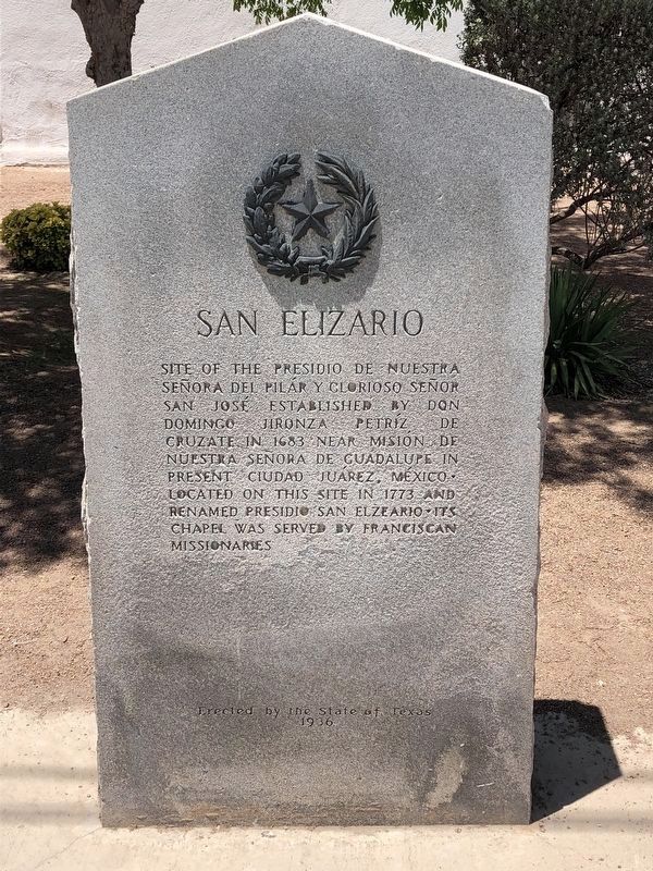
Site of the Presidio de Nuestra Señora Del Pilár y Glorioso Señor San José established by Don Domingo Jironza Petríz de Cruzate in 1683 near Misión de Nuestra Señora de Guadalupe in present Ciudad Juárez, México. Located on this site in 1773 and . . . — — Map (db m118293) HM
Site of the mission and pueblo of Nuestra Señora de la Concepción del Pueblo de Socorro established by Don Antonio de Otermín and Father Fray Francisco Ayeta, O.F.M. in 1683. Maintained by Franciscan missionaries for the civilizing and . . . — — Map (db m118295) HM
Born in Kentucky, February 15, 1795 • Came to Texas in 1822 with Austin's first colony • Died July 2, 1874 His wife Elizabeth Smith Rankin Born January 30, 1802 Died June 1, 1882 — — Map (db m164753) HM
Named in honor of
Thomas Jefferson Chambers
(1802-1865)
to whom the first land grant within
present Ellis County was made in 1834
by the Mexican government
Also known as Howe's Settlement
in honor of William R. Howe,
first settler in . . . — — Map (db m117286) HM
3 miles northeast
from here was buried
General Edward
H. Tarrant
Veteran of the War of 1812, member
of the Texas Congress and a
courageous Indian fighter • Born
in North Carolina, 1796 • Died in
Parker County, Texas, August . . . — — Map (db m117285) HM
A soldier in the Army of Texas
in 1836 • Born in Tennessee, Feb-
ruary 2, 1804; died October 15, 1891
His wife
Mary Hardeman
Born in Tennessee, February
12, 1812 • Died February 19, 1857 — — Map (db m117284) HM
Served in the Army of Texas in
1836 • Born in Alabama, September
10, 1810 • Died January 11, 1885
His wife
Isabella Weir
McDaniel
Born in Alabama, March
8, 1818 • Died May 4, 1897 — — Map (db m117283) HM
Soldier in the Texas Army in
1836 • Born in Tennessee June
17, 1808 • Died November 24, 1880
His wife
Stacy Choate Jordan
Born in Tennessee, October 15,
1816 • Died January 27, 1884 — — Map (db m117282) HM
Protector of the Texas frontier. Hero of San Jacinto. Major in the Confederate Army. Member of the Texas Congress and Legislature. Born in Vienna, Austria January 1, 1813. Died at Waco, Texas May 15, 1891. Erath County was named in his honor. . . . — — Map (db m117456) HM
Created Jan. 28, 1850, from Limestone and Milam counties. Organized Aug. 5, 1850. Named for falls on the Brazos River which flow through the center of the county.
White colonization in the area pre-dates the Texas Revolution, but colonists fled . . . — — Map (db m208477) HM
At this site, near the pioneer home of George Morgan, a battle took place, January 16, 1839, between settlers in this region and Indians under Chief José María in which the colonists were defeated.
A treaty with these Indians made soon after . . . — — Map (db m84671) HM
This area was first settled by Anglo - Americans who traveled up the Red River by steamboat in 1836. Fannin County was created in 1837, organized 1838, and named for James W. Fannin (1805-36), who was massacred with his soldiers at Goliad (March 27, . . . — — Map (db m96688) HM
(panel 1)
Born February 20, 1807 in South Carolina • Studied at South Carolina College 1825-1827
• On the staff of the Governor of South Carolina at the time of the Nullification Controversy 1832 to 1833 • Practiced law at Pendleton, . . . — — Map (db m128658) HM WM
in Texas was established at Hostyn when in November, 1856, the families of Josef Janda, Valintin Kolibal, Frantisek Koza arrived here from Czechoslovakia and in December, 1856, arrived here Alois Klimicek, Benjamin Klimicek adn Frantisek Marak. — — Map (db m71598) HM
Formed from Colorado and Bastrop Counties
Created December 14, 1837
Organized January 1, 1838
Named in Honor of
Marquis de la Fayette
1757-1834
Nobleman and Republican Friend of Washington and of the United States County Seat, La . . . — — Map (db m183276) HM
Built about 1828 - used as a place of defense against the Indians and known as Moore's Fort in honor of its builder and owner, John Henry Moore, 1800-1880, noted Indian fighter and commander of the Texans at the Battle of Gonzales, October 2, 1835 - . . . — — Map (db m53228) HM
(obverse)
First ferry in present-day Fayette County. Established about 1824 at the crossing of the La Bahia Road by Jesse Burnam. After the Army of the Republic of Texas crossed on March 19, 1836, the ferry was destroyed by order of General . . . — — Map (db m53220) HM
On the Old San Felipe Trail, in memory of John C. Robison, participant of the Battle of Velasco; Joel W. Robison, McHenry Winburn, Isaac Lafayette Hill, Spencer Burton Townsend, Stephen Townsend, veterans of San Jacinto; J.T. Townsend, John . . . — — Map (db m183314) HM
First institution of higher education in Texas. Recommended in 1837 by Martin Ruter, D.D. Chartered as a Methodist School in 1840. Granted four leagues of land by the Republic of Texas. After educating more than 8oo students it merged in 1856 . . . — — Map (db m239483) HM
Used by colonists of this vicinity as a protection against Indian attacks 1828-1842 fortified residence of Zadock Woods veteran of the War of 1812 One of the old "Three Hundred" of Austin's colonists Oldest man killed in the "Dawson Massacre" . . . — — Map (db m79696) HM
Site of old Indian trail from Mexico to settlements on Texas frontier. In this region in 1856, Colonel Robert E. Lee, then commanding the famed U.S. Second Cavalry (and later General-in-Chief of the Confederate Army), campaigned against the Indians. . . . — — Map (db m127438) HM
Formed from Hardeman, King
Cottle, and Know Counties
Created March 3, 1891
Organized April 27, 1891
Named in Honor of
Robert L. Foard
1831 - 1898
A Confederate Officer
Prominent Lawyer of Columbus
Texas
. . . — — Map (db m81442) HM
After being captured by Comanche Indians on May 19, 1836, in what is now Limestone County, Cynthia Ann Parker was recaptured here by Texas Rangers under Captain L.S. Ross on December 18, 1860 — — Map (db m170422) HM
In 1860 at the Battle of Pease River, Indian captive Cynthia Ann Parker and her daughter, Prairie Flower, were rescued by Texas Rangers under Capt. L.S. Ross (later Governor of Texas). Cynthia Ann, most celebrated of all Comanche captives, had . . . — — Map (db m170428) HM
First known as Pease · Renamed in honor of Margaret Wesley, daughter of Mr. and Mrs. John Wesley · First Anglo-American child born in Hardeman County · First county seat of Hardeman County, 1884-1890 — — Map (db m170429) HM
A veteran of San Jacinto
Born in Arkansas
May 29, 1814
Died in 1866
His wife
Sallie Pentecost Beard
Born in June, 1818
Died in 1857 — — Map (db m225902) HM
Mirabeau Buonaparte Lamar • The Father of Education in Texas • Born in Georgia August 16, 1798 • Founded the Columbus Enquirer • Came to Texas in 1836 • He commanded the cavalry at the Battle of San Jacinto • Served successively as Secretary of War, . . . — — Map (db m126864) HM
Built in November 1821 by
William Little, William
Smithers, Charles Beard,
Joseph Polly, and Henry
Holster. - Its name was
given to the county when
created in 1837. — — Map (db m126486) HM
Where a part of the Mexican Army under command of General Antonio Lopez de Santa Anna crossed the Brazos on April 14, 1836 en route to an engagement with the Texans • This occurred one week later at San Jacinto
Erected by the State of . . . — — Map (db m158527) HM
Scout under Gen. Wm. Henry Harrison, 1813 Served under Gen. Andrew Jackson, War of 1812 Alcalde, San Felipe de Austin Delegate to the Conventions of Texas, 1832-33 Member of the Consultation, 1835 Captain of A Company in the Army of Texas . . . — — Map (db m212056) HM
Alcalde, Municipality of Austin, 1827 and 1829
• President, Ayuntamiento of San Felipe, 1833
Member of the Consultation, 1835 • Signer of the Texas Declaration of Independence — — Map (db m225920) HM
Formed from Titus County
Created March 8, 1875
Organized April 30, 1875
Named in honor of
Benjamin C. Franklin
1805 – 1873
Hero of San Jacinto
District Judge of the
Republic of Texas.
Member of the . . . — — Map (db m119672) HM
Formed from Limestone County
Created September 6, 1850
Organized January 6, 1851
So named from the nature of
its stone
County Seat, Fairfield
Formerly known as Mound Prairie — — Map (db m121878) HM
Known as Big Foot Wallace • Defender of Texas and Texans • As Soldier Ranger and Mail Rider, He Protected the Advancing Frontier • Died January 7, 1899 Erected by the State of Texas 1936 — — Map (db m162717) HM
Lying in one of the first areas in Texas to be explored by the Spanish, in 1690, Frio County was created in 1858 and organized in 1871. Frio City, laid out 1871, was the first county seat, but surrendered the title to Pearsall, on the . . . — — Map (db m239489) HM
Created August 21, 1876
Organized October 24, 1905
Named for James Gaines
Born in Virginia in 1779
Established a ferry across
the Sabine River in 1819
A signer of the
Declaration of Independence
Member of the Congress
of . . . — — Map (db m61422) HM
Born in Virginia. Captain of a
company at San Jacinto, 1836 and
in command of the Mier Expedition,
1842. Died in Galveston in 1845. — — Map (db m127598) HM
Dedicated to the
First Navy of the Republic of Texas
Established by Governor Henry Smith
November 25th, 1835
The Fleet
Brutus • Independence
Liberty • Invincible
Commemorating the heroism of its
personnel . . . — — Map (db m65031) HM WM
Site of the home 1837-1851, of Gail Borden, Jr. pioneer surveyor, newspaper editor and inventor of a process for condensing milk, which he discovered while living here in 1840. Born November 9, 1801. Died September 2, 1874. — — Map (db m239912) HM
Born in Massachusetts July 26. 1805. Came to Texas February 1836 as captain of a company of volunteers he had recruited in Kentucky and Ohio. Commanded the second regiment of volunteers at San Jacinto. First to sound the immortal war cry opening the . . . — — Map (db m49823) HM
Who served in the
Army of Texas, 1836
and was a member
of the Mier Expedition, 1842
Born in New York
June 23, 1815
Died July 2, 1870 — — Map (db m127602) HM
Fort and settlement established here in 1817 by the freebooter Jean Lafitte who maintained headquarters here while preying on shipping in the Gulf of Mexico. The Battle of the Three Trees was fought here between Lafitte's men and Karankawa . . . — — Map (db m87726) HM
A signer of the Texas Declaration of Independence. Founder of the city of Galveston. Member of the Congress of the Republic of Texas. — — Map (db m150235) HM
One of the "Old Three Hundred" of Austin's colonies Surveyed the town of Galveston Editor and one of the founders in 1835 of the Telegraph and Texas Register Born in Norwich, New York, January 28, 1804 Died in Galveston, Texas March 17, . . . — — Map (db m174392) HM
Served in the Texas Army, 1836.
Purchased the Galveston News
1843. Born in New Haven, N. Y.
January 4, 1820; Died June 12, 1873.
His wife
Catherine Crosby
French Cherry
Born in Sligo, Ireland, February
22, 1826; Died . . . — — Map (db m127587) HM
Formed from
Young and Bexar Territories
Created • Organized
August 21, 1876 • June 15, 1907
Named in honor of
The Garza family
natives of the Canary Islands
Pioneer settlers of San Antonio
in 1731
A cattle raising county . . . — — Map (db m110757) HM
Established in 1849 by Doss brothers. Operated 1859-1878 by William F. Lange; 1878-1888 by Julius Lange. Its products were famed throughout the region. One of the last of the old burr mills in Texas; one of few in as perfect a state of preservation. . . . — — Map (db m91745) HM
From its summit, in the fall of 1841, Captain John C. Hays, while surrounded by Comanche Indians who cut him off from his ranging company, repulsed the whole band and inflicted upon them such heavy losses that they fled. — — Map (db m220772) HM
The trails of roving Indians
crossed these hills
Settled by German pioneers
in 1846
A group of Mormons settled
at Zodiac in 1847.
Created February 23, 1848
Organized June 5, 1848
Named for Richard Addison Gillespie
A Texan . . . — — Map (db m94337) HM
Commissioner-General of the Society for
the Protection of German Immigrants in Texas
who became a citizen of the Republic of Texas
under the name of John O. Meusebach.
Founder of Fredericksburg on May 8, 1846.
On March 1-2, 1847, he . . . — — Map (db m35893) HM
Established by the United States Army
December 5, 1848
as a protection to travelers and
settlers against Indian attack.
Named in honor of Major Martin Scott,
Brevet Lieutenant Colonel,
5th United States Infantry,
killed at Molino . . . — — Map (db m126961) HM
First known to Spanish settlers as Nuestra Senora de Loreto, later called La Bahia del Espritu Santo.
Established as a mission in 1749. Became a strategic fort under Spanish, Mexican, Texas occupancy, 1810-1821, 1835-1836. Name changed to Goliad . . . — — Map (db m34291) HM
Established in 1754
for the Cujane Nation.
Here faithful Franciscan
missionaries attempted to
Christianize and civilize
the Indians of the region
until 1794. — — Map (db m34284) HM
First established at the site of La Salle's Fort on Garcitas Creek, Victoria County, among the Coco, Cujanes, Karankawa and other Indian tribes in 1722. Moved to Mission Valley, Victoria County, on the Guadalupe River among the Jaranames and . . . — — Map (db m68955) HM
One and one-half mile from
here the first shot of the
Texas Revolution
was fired from a small cannon
by Texans under the command
of Col. John H. Moore
October 2, 1835 — — Map (db m128146) HM
Born in South Carolina December 12, 1793 Killed by Indians October 8, 1848 Served in the Army of Texas, 1835-36 Signed the Texas Declaration of Independence, 36 Member of the Senate of the Second, Third, Fourth, Fifth, Sixth, and Seventh Congresses . . . — — Map (db m239507) HM
On this site
September 29, 1835
the Mexican government troops
demanded the return of
the Gonzales cannon.
After two days delay,
awaiting recruits, the colonists
answered, "Come and Take It." — — Map (db m128151) HM
On this site
September 29, 1835
the Gonzales cannon was buried
from the 150 Mexican Dragoons
sent to demand it.
Two days later it was mounted
on ox-cart wheels, loaded with
chains and scrap iron, and fired
at the Mexican Army, the . . . — — Map (db m128170) HM
Alcalde Author of the historic Letter written on Sept. 26, 1835, in reply to Mexico's demand for the colonists cannon at Gonzales. One of the defenders of Gonzales October 2, 1835 — — Map (db m239508) HM
A San Jacinto Veteran • Born in Alabama, January 11, 1802 Died December 28, 1869 His Wife Eliza Davis Born in Alabama, May 12, 1819 Died January 11, 1875 — — Map (db m239509) HM
1/8 mile north is
Sam Houston Oak
where General Sam Houston
established his headquarters camp
March 13, 1836
after burning the town of Gonzales
Under this oak his
small army was joined by
many volunteers from the
eastern . . . — — Map (db m128178) HM
Extending from this point
one-quarter mile west is
Santa Anna Mound
formerly De Witt Mound
now site De Witt Family Cemetery.
Here Mexican troops camped
between September 29 and
October 1, 1835, awaiting delivery
of the Gonzales . . . — — Map (db m128152) HM
Who with her daughter
Evaline
made the first battle flag of Texas
used by the colonists in the
Battle of Gonzales, October 2, 1835
Born in Virginia, 1789
came to Texas in 1826
with her husband
Green De Witt, Empresario,
and their . . . — — Map (db m128150) HM
In Memory of the Immortal 32 Gonzales men and boys who, on March 1, 1836 fought their way into the beleaguered Alamo to die with Colonel William B. Travis for the Liberty of Texas. They were the last and only reinforcements to arrive in answer to . . . — — Map (db m128175) HM
On this site,
September 29, 1835
began the strategy of
the 18 Texians who by advising
with Alcalde Andrew Ponton, held
for two days 150 Mexican dragoons
sent to demand the Gonzales cannon,
allowing colonists time to mass
recruits for . . . — — Map (db m123671) HM
Born in Rutland, Vermont 1799 Died in December, 1884 His
Wife Hester Lee Born in Rutland, Vermont Died in 1888 Erected by the State of Texas — — Map (db m163286) HM
In this vicinity Lieutenant Frank D. Baldwin, commanding two companies of United States troops, attacked a large band of Indians and rescued two white girl captives, November 8, 1874. — — Map (db m151620) HM
Ten miles southwest of here Lieutenant Frank D. Baldwin commanding two companies of United States troops attacked a large band of Cheyenne Indians and rescued two white girl captives, November 8, 1874. — — Map (db m239511) HM
Formed from Young and Bexar
Territories
Created August 21, 1876
Organized May 27, 1902
Named in Honor of
Peter W. Gray
1819–1874
Member of the First Legislature
of Texas
Member of the Confederate Congress
Appointed to . . . — — Map (db m55821) HM
Established about 1853 by Benjamin F. Colbert. Across it came thousands of immigrants into Texas in the fifties. The stages of the Southern Overland Mail Line, which provided mail and passenger service between St. Louis and San Francisco, crossed . . . — — Map (db m212089) HM
Established by William G. Cooke in 1840 as a part of the defense of the Military Road from Red River to Austin. Named in honor of Colonel Francis W. Johnson (1799-1888). Commander of the Texas Army at the capture of San Antonio, December 10, 1835. . . . — — Map (db m223628) HM
Established about 1837 for trade with the Indians of the Red River region and the western plains. Here many white captives of the Red Men were redeemed. From its vicinity the Snively Expedition set out for New Mexico on April 25, 1843. Abandoned . . . — — Map (db m223626) HM
Formed from Rusk and Upshur counties. Created April 12, 1873; organized June 28, 1873. Named in honor of General John Gregg (1828-1864). Delegate to Secession Convention and to the Provisional Congress of the Southern Confederacy; a Confederate . . . — — Map (db m218642) HM
Built in 1834 by Henry Fanthorp as a home for his bride, Rachel Kennard. Enlarged for hotel purpose. Served as first mercantile establishment and first post office (1835) in the region. Here Kenneth Lewis Anderson, Vice-President of the Republic of . . . — — Map (db m118940) HM
On road used 1690 by Spanish explorer Alonso de Leon. In 1821 Andrew Millican began settlement. Henry Fanthorp opened his inn 1834, a post office 1835. Kenneth Anderson, last Vice-President, Republic of Texas, died at Fanthorp's, 1845. After his . . . — — Map (db m118977) HM
Of the Southern Confederacy established in 1861 · In operation until 1865 · Cannon, cannon balls, guns, pistols, swords, sabers, bayonets and gun powder were manufactured
Erected by the State of Texas 1936 — — Map (db m157882) HM
In memory of
Colonel Benjamin Fort Smith,
Dr. Robert C. Neblett, Veterans of
The War of 1812
Colonel Benjamin F. Smith
Veteran of the Black Hawk War, 1832
Jared E. Groce, Joshua Hadley
William Robinson, delegates to the
First . . . — — Map (db m118943) HM
Generally known as "Groce's Retreat" • Here he died November 20, 1836 • • The name "Retreat" was continued for a postoffice and village two miles to the east after the house was torn down — — Map (db m169378) HM
Where 80 volunteers commanded by General Edward Burleson defeated Vicente Cordova and 75 Mexicans, Indians and Negroes, March 29, 1839, and drove them from Texas, ending the "Cordova Rebellion." 25 of the enemy were killed. Many volunteers were . . . — — Map (db m128126) HM
A San Jacinto Veteran • Born in Georgia, February 14, 1807 Died December 14, 1890 His Wife Jane Johnson Dale Born in Ohio, August 3, 1821 Died June 17, 1896 — — Map (db m239512) HM
A soldier in the Army of Texas in the Mier expedition, 1842 Born in Virginia Died in Seguin, Texas October 28, 1854 Erected by the State of Texas 1936 — — Map (db m158352) HM
Formed from
Gonzales and Bexar counties
Created March 30, 1846. Organized July 13,1846
Named for the Guadalupe River
to which this name was given
by Alonso De Leon
in 1689
Seguin, the county seat
named in honor of
Juan Nepomuceno . . . — — Map (db m128120) HM
Stretching onward toward the sunset, o'er prairie, hill and vale, far beyond the double mountains winds the Old MacKenzie Trail.
Ah, what thoughts and border memories does that dreaming trail suggest; thoughts of travelers gone forever to the . . . — — Map (db m91267) HM
Formed from Young and Bexar
Territories
Created • Organized
August 21, 1876 • June 23, 1890
Named in honor of
Warren D.C. Hall
1788 – 1867
Member of
The San Felipe Convention in 1832
Second in Command of . . . — — Map (db m96346) HM
Created February 2, 1842 from Montgomery and Houston counties
Recreated January 22, 1858
Organized August 2, 1858
Named in honor of General James Hamilton, 1786-1857
Lawyer and Governor of South Carolina
Appointed diplomatic agent to . . . — — Map (db m120949) HM
814 entries matched your criteria. Entries 201 through 300 are listed above. ⊲ Previous 100 — Next 100 ⊳