611 entries match your criteria. The first 100 are listed. Next 100 ⊳
Quakerism Historical Markers
This series is on the history of Quakers (The Religious Society of Friends), including notable Meeting Houses, burial grounds, individuals, settlements and schools.
This series is not about things named after Quakers but are not related to Quakerism, such as Quaker State Oil or Quaker Oats.
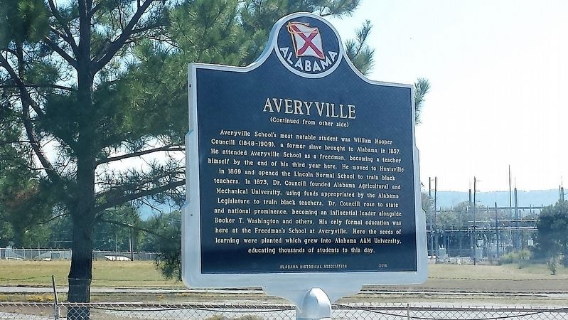
During the Reconstruction Period following the Civil War, a freedmen’s community was established in this area called Averyville, named for the Pennsylvania minister and successful businessman Charles Avery, a longtime and faithful champion of Negro . . . — — Map (db m108803) HM
Born April 23, 1781 in Hanover Co. Virginia, married there to Martha Hargrave of a wealthy Quaker family. He served as U.S. Marshall and in other positions. Moved to Kentucky in 1808. Was a Captain in the War of 1812 and became a political and . . . — — Map (db m29284) HM
Disease, death, the practice of separating slave families—all left
children with no one to care for them. Scores of orphaned black
children in Civil War Helena suffered from neglect and exposure.
General Napoleon Buford asked for help. In . . . — — Map (db m107999) HM
Founded 1783 on the tract “Brecknock” by Daniel Mifflin and settled largely by Quakers. Once called Piccadilly and Mifflins Cross Roads. Incorporated 1852, it was a center of anti-slavery sentiment. Several homes were by tradition stops . . . — — Map (db m168332) HM
By the end of the 18th century this area was home to a large number of African Americans, many of them freed slaves. Their settlement was largely due to the efforts of local Quakers. A congregation of the African Methodist Episcopal Church was . . . — — Map (db m39605) HM
This house of worship, built in 1805, was first a Preparative Meeting under the care of Motherkiln (Murderkill) Monthly Meeting of the Religious Society of Friends (Quakers). In 1830, Camden Monthly Meeting was formed by uniting with Motherkiln and . . . — — Map (db m39513) HM
Chief engineer of the Underground Rail Road in the State of Del. and the richest man in Del. He was convicted and fined in 1846 by the U.S. Dist. Court, later he was fined twice for $10,000.00 each by Del. but was advised the fines wouldn't be . . . — — Map (db m227863) HM
Quakers were gathering for worship in this area by 1712, when members of the Religious Society of Friends met "at the widow Needham's at Murderkill Creek." Established as Motherkiln Preparative Meeting (under the care of Duck Creek Meeting), the . . . — — Map (db m39459) HM
A native of Virginia's Eastern Shore, Mifflin came to Delaware as a young man. Born into a slaveholding Quaker family, he manumitted his own slaves in 1774-75 and later became one of America's foremost abolitionists of the 18th century. As an elder . . . — — Map (db m39456) HM
The first religious organization to hold services in Duck Creek Hundred - 1705. Property transferred to Duck Creek Historical Society - 1962. Michael Desmond, Jr's Eagle Scout Restoration Project - 2002. — — Map (db m39711) HM
The Hockessin Friends Meeting has operated with an active membership and regular services, known as Meetings for Worship, since its founding. The Meeting is part of the larger Philadelphia Yearly Meeting faith community.
The expansion of the . . . — — Map (db m92144) HM
Total Pencader Population: 2,132 100%
Number of Free Black Residents in Pencader:201 9% of Total Population
Number of Free Black Persons Living in Free Blk. . . . — — Map (db m238418) HM
Ashton Richardson built Ashley Mansion in 1804 on land he inherited from his father. A prominent Quaker, Ashton Richardson owned several milling operations and was considered one of the most eligible bachelors in the area. After marrying in 1807, . . . — — Map (db m196413) HM
Believed to be one of the smallest Quaker Meeting Houses in the nation, the Appoquinimink Friends Meeting House was built in 1785 by David Wilson and presented to the Friends as a gift. Local tradition identifies this structure as a stop on the . . . — — Map (db m10308) HM
The construction of Town Hall began in 1798. Completed the following year, this was the first structure in Wilmington built for government use. It was designed by a building committee which followed the Borough Council’s request that the structure . . . — — Map (db m165578) HM
The oldest existing school in Delaware, Wilmington Friends was founded in 1748. It resided in the first meeting house of the Wilmington Meeting of the Religious Society of Friends (Quakers) at Fourth and West Streets, which had been built ten . . . — — Map (db m140064) HM
Not Just Workers, But Family
For as long as this was a family business, workers at Bancroft Mills were treated as members of the family. Long before workers had any rights, Joseph Bancroft and his sons provided decent wages and benefits not . . . — — Map (db m240816) HM
Bancroft Mills became a leading manufacturer through one family's business sense and Quaker values.
The Founder
Joseph Bancroft was both a devout Quaker and a wise businessman. By keeping his company up-to-date on new trends and . . . — — Map (db m240759) HM
This Historic Trail links the historical, social, and cultural patterns of development in Wilmington. The commercial and residential structures along this trail recreate the vitality and historic importance of 17th and 18th-century Wilmington. The . . . — — Map (db m130469) HM
Grew from New-Wark Meeting established 1682. Present house is third in this vicinity. Friends School begun here in 1748 has operated continuously. Among 3,000 buried in yard are founders of Wilmington, John Dickinson, "Penman of the Revolution," and . . . — — Map (db m10943) HM
Born August 21, 1789, in Upper Darby, Pennsylvania, Garrett came to Wilmington in 1822. A prominent merchant, his home and business were located nearby on Shipley Street. Garrett was committed to the anti-slavery efforts of his Quaker faith. He is . . . — — Map (db m67356) HM
The first Meeting House on this site was built in 1738. It was replaced in 1748 when a larger building was constructed. The old Meeting House was then converted into a school. Known as Wilmington Friends School, it was relocated to a new facility in . . . — — Map (db m10941) HM
By the late 1700s the institution of slavery was declining in Delaware. A changing economy and the active efforts of Quakers and Methodists had led to the manumission of many slaves and dramatic growth of the state’s free black population. Though . . . — — Map (db m168333) HM
In 2013, Howard University archaeologists, working with concerned citizens, completed a seven-year survey of Walter C. Pierce Community Park. Their goal: to identify and protect two 19th Century cemeteries--the Colored Union Benevolent . . . — — Map (db m112588) HM
In 2013, Howard University archaeologists, working with concerned citizens, completed a seven-year survey of Walter C. Pierce Community Park. Their goal, to identify and protect two historic cemeteries—the Colored Union Benevolent . . . — — Map (db m236781) HM
The African American and Quaker cemeteries here were almost lost to time. Both closed in 1890 due to development. Parts of the land were sold to the National Zoo and National Park Service. Developers bought the rest and tried . . . — — Map (db m236780) HM
Today's Walter Pierce Park was once the site of two cemeteries—the Friends (Quaker) Burying Ground, in use from 1807 to 1890, and Mt. Pleasant Plains Cemetery, where more than 8,400 African Americans were buried between 1870 and 1890. . . . — — Map (db m236776) HM
The Peirce Still House, built between 1796 and 1811, was part of a large plantation owned by Isaac Peirce, a Quaker from Pennsylvania and slave owner, who purchased the property in 1795. Much of the Peirce Estate became part of Rock Creek Park when . . . — — Map (db m82098) HM
Paul Leroy Robeson (April 9, 1898 - January 23, 1976) was the son of William Drew Robeson a runaway slave and Maria Louisa Bustill, daughter of a prominent Philadelphia Quaker family. Maria died tragically in a fire when Paul was six years old.
. . . — — Map (db m112942) HM
The great Quaker naturalist of Philadelphia made a long journey through the southeastern states in the 1770's collecting botanical specimens. In May, 1774, he visited the Seminole Chief, Cowkeeper, at the Indian village of Cuscowilla located near . . . — — Map (db m146839) HM
Three miles to the east on September 23, 1696, the British barkentine Reformation foundered off Jupiter Island. The 24 survivors included a party of Quakers bound from Jamaica to Pennsylvania. Leader of the Quakers was Jonathan Dickinson who . . . — — Map (db m14311) HM
This highway has been following closely the course of the Old Quaker Road, one of Georgia's earliest vehicular thoroughfares. It was opened about 1769 to link Savannah, the colonial capital, with a Quaker settlement centering around Wrightsboro in . . . — — Map (db m7992) HM
The highway bearing left is the Old Quaker road, on of Georgia's earliest vehicular highways. It was opened about 1769 to provide a direct way from Savannah to a Quaker settlement centering around Wrightsboro in today's upper McDuffie County. . . . — — Map (db m8022) HM
Columbia County, named for Christopher Columbus, was created by Act of Dec. 10, 1790 from Richmond County. Originally, it contained parts of McDuffie and Warren Counties. Settled by Quakers before the Revolution, it has been the home of many . . . — — Map (db m27049) HM
The highway crossing here is the Old Quaker Road, one of Georgia’s earliest vehicular thoroughfares. It was opened about 1769 to provide a direct way from Savannah, the Colonial capital, to a Quaker settlement centering around Wrightsboro in today’s . . . — — Map (db m15899) HM
On this site in 1754, Edmund Grey, a pretending Quaker, founded the town of Brandon, named for one of its leaders. In Dec. 1768, Joseph Mattock and Jonathan Sell, Quakers, obtained a grant of 40,000 acres from the Royal Governor, Sir James Wright, . . . — — Map (db m42657) HM
1799 House of Worship for All Denominations
1810 Wrightsboro Church Constructed
1837 Methodist Episcopal Church South
1939 Methodist Church
1966 Property to McDuffie County Commission
1967 Wrightsboro . . . — — Map (db m110717) HM
Society of Friends (Quakers) built the Cain Church in 1871 as their meetinghouse and has since been used by several denominations. It was originally located southwest of Harrisburg in Section 20. — — Map (db m146832) HM
Chief Little Turtle was one of the most feared and respected leaders during the frontier wars of the 1780s and 1790s when Fort Wayne was born. Known to his people as Meshekinnoquah, Little Turtle is thought to have been born in 1752 in a village . . . — — Map (db m21503) HM
Free people of color left the South starting in the 1820s as threats to freedom and property escalated with slavery expansion. In 1835, Hansel and Elijah Roberts and Micajah Walden of North Carolina bought land in Hamilton County near anti-slavery . . . — — Map (db m98840) HM
has been the site of annual meeting of Religious Society of Friends since 1858. The Depository was erected to house Quaker records, 1873. Friends Central Academy served as secondary school, 1881-1919. — — Map (db m69404) HM
Early Quaker settlement established 1836; center of Underground Railroad activity. Meeting house erected here, 1840, on land donated by Enos and Margaret Lewis; used by Congregational Friends, by Spiritualist society, as school, community hall; . . . — — Map (db m214984) HM
Near here settled pioneer Quakers, including the Aaron Stanton Family. In 1836 William Bond agreed to convey the Society of Friends three acres of land for a meeting house lot and burial ground. Bond died in 1837 and in 1841 the La Porte Circuit . . . — — Map (db m77105) HM
Settled by Quakers and African-American Freedmen farmers from the Carolinas, Randolph County provided a corridor for the mid-19th century Underground Railroad. In the decades following the Civil War, the drilling of natural gas brought major glass . . . — — Map (db m238979) HM
The second of seven children of a Quaker cotton manufacturer and abolitionist, Susan Brownell Anthony learned to read and write at just 3 years old. Her father structured her upbringing around self-discipline, principled beliefs and self-respect. . . . — — Map (db m132842) HM
The West Union Friends Meeting was established in 1832 by Quakers from North Carolina. It was the first church and school in Monrovia which was established in 1834 by Quakers Gideon Johnson and George Hubbard. Members of the West Union Friends . . . — — Map (db m233821) HM
An 1860 addition to Western Manual Labor School. The school was operated by Quakers from 1846 to 1916. The name was changed to Friends Bloomingdale Academy in 1862. — — Map (db m17258) HM
Born in Randolph Co. circa 1828 to Quaker family, Way was advocate for women’s rights and temperance. Founding member of Indiana Woman’s Rights Association, 1851; participant in “Whisky Riot” here, 1854; and nurse in Civil War. She . . . — — Map (db m120249) HM
(Side One)
When this meeting house was dedicated 1898, membership in Quarterly Meeting of Friends at Winchester was largest in the world. Migration of the Religious Society of Friends (Quakers) into this area began 1814 with the arrival . . . — — Map (db m69283) HM
Randolph County's religious roots reveal a deeply tolerant and progressive community. Beginning in 1814, members of the Society of Friends (Quakers) first worshiped collectively in the area. Other frontier believers worshiped before the preaching of . . . — — Map (db m222248) HM
Buddell Sleeper (1806-1888) and his wife, Elizabeth Welch (1802-1889), arrived in Tippecanoe County in the Fall of 1835. The Sleepers would become prominent members of the Farmers Institute Quaker Community and the Greenfield Monthly Meeting of . . . — — Map (db m175614) HM
Opened in 1851, this was the first school of higher learning in rural Tippecanoe County, built by Society of Friends (Quakers) of this neighborhood. Enrollment included local, non-local and youth of other states. Primary through college preparatory . . . — — Map (db m34909) HM
Site of station of Underground Railway used by Quakers during pre-Civil War days in smuggling slaves to Canada. Leader of the enterprise was Buddell Sleeper. — — Map (db m34871) HM
A convention was called for by reform-minded Congregational Friends meeting at Greensboro, Henry County, January 1851. Convention held October 14-15, 1851 at Dublin adopted resolutions for political, social, and financial rights for women. Women and . . . — — Map (db m270) HM
(Front Side): Levi Coffin (1798-1877), a Quaker abolitionist, lived in Newport (now Fountain City) with his family 1826-1847. Moved from North Carolina because he and his wife, Catharine, opposed slavery. Advocated, and sold in his store, . . . — — Map (db m4480) HM
On October First, 1842, in what was then an open tract in this city
square. Henry Clay, the leader of the Whig Party, delivered an
address to an immense multitude and Hiram Mendenhall, a Quaker
abolitionist, presented to him on behalf of the . . . — — Map (db m138953) HM
The Hoover family worshipped in this building along with neighbors and relatives who were members of the Religious Society of Friends, or Quakers as they are often called. West Branch was predominately a Quaker community in the 1850's when this . . . — — Map (db m48312) HM
In this meetinghouse, the Religious Society of Friends, or Quakers, practiced principles of simplicity, honesty, equality, peace, and service to others. These values shaped young Hoover's character and were evident in his humanitarian endeavors and . . . — — Map (db m162636) HM
The early settlers of West Branch had a strong regard for education, and in 1853 they built this school. It was used not only as a school but as a place of worship for the members of the Society of Friends. Originally the building housed all of the . . . — — Map (db m162553) HM
From 1837 to 1869 the Quaker Mission educated the children from area Indian settlements. The early settlers of Campbellton sent their children to the Hickory Grove School, which was located near present day Shawnee Mission North High School.
As . . . — — Map (db m50579) HM
Religious missionaries of nearly all denominations were present throughout Indian settlements as early as the 1680’s. Missionaries were intent on converting the Native Americans to Christianity. Quakers (The Society of Friends) had worked among the . . . — — Map (db m46855) HM
In 1825 the Federal government began moving Eastern Indians to new lands west of the Mississippi. This sign is on a 2,500 square mile tract assigned to the Shawnees.
With this tribe came Methodist, Baptist and Quaker missionaries. One mile east . . . — — Map (db m20906) HM
Friends (Quaker) Meeting House, Corner of Federal and Pearl Streets. Famous abolitionist William Lloyd Garrison started the Maine anti-slavery movement with a speech given here in 1832. Garrison advocated "immediate emancipation without . . . — — Map (db m96520) HM
Surveyed, 1663, as Holland’s Hills for Francis Holland; bought 1665, by Richard Harrison, Quaker planter and shipowner, who owned about 6,000 acres. The house, built in three stages between 1665 and 1733 by Richard Harrison and his son Samuel, is . . . — — Map (db m2938) HM
Cedar Park
Patented to Richard Ewen in 1666 as “Ewen upon Ewenton.” Brick house built c.1697 by Richard Galloway II around earlier frame structure possibly dating back to 1656. Known as “West River Farm” in 18th Century. . . . — — Map (db m65889) HM
The members of the Galesville Heritage Society invite you to explore their historic village. First settled in 1654 on the banks of West River, Galesville and its history are fundamentally linked to the Chesapeake Bay. Native Americans, English . . . — — Map (db m6201) HM
Site of
First Quaker Regional Gathering
In Maryland
By George Fox in 1672
Ann of Arundell Chapter, MD.
National Society of Colonial
Dames XVII Century
1999 — — Map (db m65888) HM
Here April, 1672, George Fox, founder of Quakerism, opened the first General Meeting of Friends in Maryland, marking the beginning of West River Yearly Meeting and its successor, Baltimore Yearly Meeting of Friends. Site of West River Quaker Meeting . . . — — Map (db m3038) HM
Visited his Quaker friend William Richardson near this spot after the conference at Col. Thomas Tailler’s December 13, 1682. Lord Baltimore and the members of his Council accompanied him to this place. — — Map (db m3039) HM
Attended a meeting of the Friends (Quakers) at Thomas Hooker’s December 1682 on this tract called “Brownton” (patented in 1652 for 660 acres). Penn sailed from here across the Bay to the Choptank River to a General Meeting of the Friends. — — Map (db m3041) HM
Clifton Mansion was the summer residence of Quaker merchant Johns Hopkins. In founding the Johns Hopkins University, Hospital, and Medical School, Hopkins transformed higher education, medicine, and the City of Baltimore. He became the first . . . — — Map (db m189862) HM
“Ruscombe” (meaning brown hill) was built in 1866 by James Wood Tyson, the younger brother of Jesse Tyson who built the nearby Cylburn Mansion. By the 1860’s, the Tyson dynasty, long one of Baltimore’s pre-eminent Quaker and . . . — — Map (db m114587) HM
On this site was erected Patapsco Friends Meeting House 6th Mo. 12th, 1681 is the earliest record of this meeting. Removed to Aisquith & Fayette Sts. Baltimore Town 2nd Mo. 22nd, 1781. — — Map (db m65715) HM
The Friends Meeting House is the oldest religious building in Baltimore. In 1781, the Patapsco Friends Meeting, formerly located on Harford Road two miles north of the Inner Harbor, moved to this site. In 1784 a group of Quakers established a school . . . — — Map (db m6282) HM
Before Baltimore's public school system opened in 1829, education was the concern of charitable and religious organizations. An early leader in the education movement was the McKim Free School, established through a bequest of Quaker merchant . . . — — Map (db m7071) HM
Coming from their camp at White Marsh in the early afternoon of Wednesday, 12 September 1781, the First Brigade of French forces, consisting of the infantry regiments Bourbonnais and Royal Deux-Ponts marched into Baltimore on Pulaski Highway [US . . . — — Map (db m166667) HM
The Taylor family, whose land holdings in area by end of 17th century were extensive, constructed of logs on this site c. 1770 a Quaker Meeting House, later used for Methodist services. It was razed when present stone chapel was built in 1853. . . . — — Map (db m114577) HM
The Underground Railroad was a network of American abolitionists who aided and sheltered 100,000 African Americans seeking freedom from enslavement in the South. These Freedom Seekers often journeyed north by land, and many crossed into the free . . . — — Map (db m243532) HM
This house was built in 1789 by George Ellicott, a Quaker, who was a miller, surveyor, merchant and astronomer. He was friend and advisor to America's first black man of science, Benjamin Banneker, who visited here. He also entertained Chief Little . . . — — Map (db m193) HM
With more free than enslaved blacks and a sympathetic Quaker population, Caroline County was a hotbed of Underground Railroad activity until slavery was abolished in Maryland in 1864.
Slaves, freemen of color, and whites often . . . — — Map (db m205449) HM
The Quakers, also known as Friends, who met in this Meeting House not only held strong opinions on the abolition of slavery and women’s rights, but they also acted on those beliefs.
After 1790, the Friends who gathered here refused membership to . . . — — Map (db m79354) HM
Refugees from slavery came here for temporary sanctuary.
Under the cover of darkness, they crept across these fields toward the home of Quaker Jacob and Hannah Leverton. The house, a rare, documented Underground Railroad station, still . . . — — Map (db m79303) HM
Daily life at and around Linchester Mill provided fertile yet dangerous ground for those seeking freedom.
The mill, a general store, post office and homes at this site brought whites and blacks, free and enslaved, into regular contact. . . . — — Map (db m79299) HM
After Quakers sold their meetinghouse to the local black community in 1849, the new owners established Mt. Pleasant Methodist Episcopal Church. The original church building has since burned, but the modern day congregation still uses the . . . — — Map (db m79178) HM
Among the factors that contributed to the coming of the Civil War was the increasing animosity between Southerners and Northerners over the issue of slavery. The operation of the Underground Railroad to help slaves escape to the free North and . . . — — Map (db m5411) HM
About 1735 William Farquhar and Ann his wife held a Friends (Quaker) Meeting at his house. In 1771 he deeded two acres of land on which the Meeting House and burying ground are located. Ex-President Hoover’s ancestors were members of this Meeting. — — Map (db m3015) HM
40-acre grant from William Penn in 1701 on which present East Nottingham Friends Meeting House built, 1724, with stone addition completed in 1752. Used as American army hospital in 1778. Cross Keys Tavern, built in 1744, was mid-way on Old . . . — — Map (db m145437) HM
When Harriet Tubman engaged with the Underground Railroad, she tapped into a secret network of people who firmly believed it was time to end slavery. There were always some enslaved people who seized opportunities to flee to freedom, but by the . . . — — Map (db m205003) HM
Established 1772 by David Lee a Quaker from Bucks County, Pennsylvania. A gun manufactory back of the mill furnished guns for the Revolution in 1776. The original tract called Jerusalem patented 1687. — — Map (db m1253) HM
After founding the town of Ellicotts Mills in 1772, the Ellicott brothers established this burying ground in 1795 and built the adjacent Friends Meeting House in 1800. — — Map (db m112272) HM
“New Lisbon” was established by Quaker Caleb Pancoast in 1802, who saw both need and opportunity to service travelers along the length of the National Pike. He also welcomed all religious denominations into his home, and allowed it to be used as a . . . — — Map (db m5744) HM
The Briggs House was built in 1803 for Hannah Brooke Briggs and her husband Isaac Briggs, who were still living here in 1814. The Briggses also owned a house and farm known as Sharon in Sandy Spring. Hannah, a devout Quaker, married Isaac Briggs in . . . — — Map (db m128850) HM
In 2004, this trail corridor was named in honor of the mother of the modern environmental movement, Rachel Carson. When complete, the Rachel Carson Greenway Trail will be 25 miles long, connecting the Anacostia Trail System in Prince George's . . . — — Map (db m114413) HM
611 entries matched your criteria. The first 100 are listed above. Next 100 ⊳