259 entries match your criteria. Entries 201 through 259 are listed.⊲ Previous 100
Santa Fe Trail Historical Markers
This is an important trade route from New Franklin, Missouri (and parts west as the railroad moved west) to Santa Fe, New Mexico. The trail was in use from 1822 until the late 1880s.
On State Road 120 just east of Interstate 25, on the right when traveling east.
Wagon Mound is the westernmost natural landmark on the Santa Fe Trail. It could be seen for miles by weary travelers making their way over the long and arduous road. The promontory was named by the trail travelers for its resemblance to a large . . . — — Map (db m156740) HM
On State Road 120 at Interstate 25, on the right when traveling east on State Road 120.
This last great landmark on the Santa Fe Trail was named for its resemblance to the top of a covered wagon. At Wagon Mound, travelers could cross from the Cimarron Cutoff to Fort Union, which is located on the Mountain Branch of the Trail. The two . . . — — Map (db m45824) HM
On New Mexico Route 161, 2.3 miles north of Interstate 25, on the right when traveling north.
The low line of trees to the south marks La Junta (the junction) of the Mora and Sapello Rivers. It is also known as La Junta because its location is where the Cimarron and Mountain Branches of the Santa Fe Trail join. Arriving with the U.S. . . . — — Map (db m156802) HM
Near New Mexico Route 161, 2.6 miles north of Interstate 25, on the left when traveling north.
In 1848, the U.S. Secretary of War ordered Lieutenant Colonel Edwin V. Sumner, as commander of the Ninth Military Department to "revise the whole system of defense (sic)" in the New Mexico Territory. The immediate goal was to move U.S. troops out of . . . — — Map (db m156808) HM
Near New Mexico Route 161, 7.5 miles north of CanAm Highway (Interstate 25).
The deep ruts etched into the earth in front of you are a record of Fort Union's role as the guardian of the Santa Fe Trail. Formed from a network of routes used for hundreds of years by American Indians, Spaniards, Mexicans, New Mexicans, and . . . — — Map (db m148988) HM
On New Mexico Route 161, 6.6 miles north of Interstate 25, on the left when traveling north.
Fort Union Arsenal (marker south side)West of Fort Union near the base of the mesa are the ruins of Fort Union Arsenal. The first Fort Union was built at this location in 1851. In 1867 this wooden fort was razed and the adobe Arsenal . . . — — Map (db m156765) HM
Near Interstate 25 at milepost 375.5,, 8.6 miles north of State Road 161.
Fort Union National Monument 1851-1891
Once the largest post in the Southwest, Fort Union was established to control the Jicarilla Apaches and Utes, to protect the Santa Fe Trail, and to serve as a supply depot for other New Mexico forts. . . . — — Map (db m45829) HM
Near New Mexico Route 161, 7.5 miles north of CanAm Highway (Interstate 25).
You are looking at the largest United States military base to be found for 500 miles in any direction during the late 1800s. There was nothing bigger from Kansas to California. For 25 years, this frontier-era Army post was a federal government-run . . . — — Map (db m148970) HM
On New Mexico Route 161, 2.3 miles north of Interstate 25, on the right when traveling north.
On the indigenous pathway that became the Santa Fe Trail, Native Americans long traveled and traded. After Mexico gained independence from Spain in 1821, the Santa Fe trail developed as an international commercial highway connecting Mexico with the . . . — — Map (db m156800) HM
Near New Mexico Route 161, 7.5 miles north of CanAm Highway (Interstate 25).
For 24 years the officer in command of the cavalry and infantry troops at Fort Union lived here. The post commandant issued the orders that determined the daily duties and routines for hundreds of enlisted men, non-commissioned officers, officers, . . . — — Map (db m149000) HM
On New Mexico Route 161, 2.3 miles north of Interstate 25, on the right when traveling north.
On the hillside in front of you, the wagon ruts of the Santa Fe Trail bear silent witness to the passage of time and nations moving east and west. When Mexico won its independence from Spain in 1821, legal trade began between the United States and . . . — — Map (db m156801) HM
Near New Mexico Route 161, 7.5 miles north of CanAm Highway (Interstate 25).
This square, open yard was once full of men hard at work. The Santa Fe Trail and the rough, unpaved roads of New Mexico Territory in the 1800s were tough on freight wagons — and the livestock that hauled them. Inside this Mechanics' Corral . . . — — Map (db m149007) HM
On New Mexico Route 161, 0.6 miles south of CanAm Highway (Interstate 25), on the left when traveling south.
For westbound travelers, camping here in this green river valley meant that their journey on the Santa Fe Trail was almost over. For travelers headed east it represented a decision, for the trail split here into two very different adventures. The . . . — — Map (db m148818) HM
Near New Mexico Route 161, 2.6 miles north of Interstate 25, on the left when traveling north.
The landscape before you has changed little over time. It remains remote and quiet, with little visible evidence of human influence. The Sangre de Cristo Mountains in front of you formed as ancient sedimentary rocks were faulted upward. Lying in . . . — — Map (db m156799) HM
Near New Mexico Route 161, 7.5 miles north of CanAm Highway (Interstate 25).
Soon after a Confederate army from Fort Bliss, Texas invaded southern New Mexico in July 1861, over 200 men found themselves here, working 4-hour shifts, day and night. With picks and shovels they raised a new Fort Union surrounded by earthworks. . . . — — Map (db m148996) HM
On Interstate 25 at milepost 374, on the right when traveling north.
Opened by William Becknell in 1821, the Santa Fe Trail became the major trade route to Santa Fe from Missouri River towns. The two main branches, the Cimarron Cutoff and the Mountain Branch, joined at Watrous. Travel over the Trail ceased with the . . . — — Map (db m55199) HM
Near New Mexico Route 161, 7.5 miles north of CanAm Highway (Interstate 25).
To us today, Fort Union looks like a single, very large Army base. Soldiers who served here from 1863-1891 saw things in a completely different way. For them, the Post of Fort Union and the Fort Union Quartermaster Depot were like two small towns . . . — — Map (db m149003) HM
Near New Mexico Route 161, 7.5 miles north of CanAm Highway (Interstate 25).
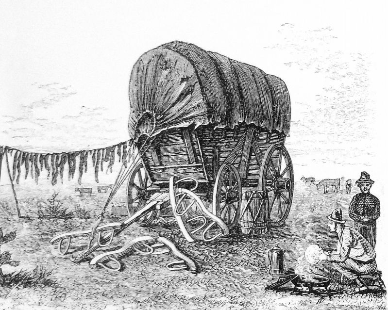
Think of what you see here as the forerunner of today's busy truck stops on the interstates. Now, freight rides cross-country safe inside boxes of steel and aluminum, rolling on rubber tires. In the mid-1800s, cargo rode under canvas on iron-shod . . . — — Map (db m149006) HM
Near New Mexico Route 161, 7.5 miles north of CanAm Highway (Interstate 25).
If you look straight ahead about a mile, you can see the site of the first Fort Union. There, at the foot of the mesa, soldiers quickly threw up buildings made from logs and uncured, rough-sawn lumber in the summer of 1851. Their mission was to . . . — — Map (db m149182) HM
Near New Mexico Route 161, 7.5 miles north of CanAm Highway (Interstate 25).
Today it's tough to look at the low wagon wheel ruts of the Santa Fe Trail — just ahead of you and grasp how many tens of thousands of lives this road turned upside down. Comanche, Kiowa, Jicarilla Apache, Mountain Ute, and other American . . . — — Map (db m149008) HM
Near New Mexico Route 161, 7.5 miles north of CanAm Highway (Interstate 25).
The Six Mule Army Wagon contributed to the military's success in the Southwest. With its simple design and iconic red and blue paint scheme, the Six Mule Army Wagon, nicknamed the "Old Army Six Mule", performed the critical role of linking . . . — — Map (db m148980) HM
Near New Mexico Route 161, 7.5 miles north of CanAm Highway (Interstate 25).
Unlike its predecessors, the Third Fort Union was carefully planned. Building materials included native stone, adobe bricks — fashioned from soil dug from a field north of the fort site — and bricks manufactured in the nearby town of Las . . . — — Map (db m148997) HM
Near New Mexico Route 161, 2.6 miles north of Interstate 25, on the left when traveling north.
Like surging tides upon the shore, a procession of human cultures has influenced this region. Each new wave of people left unique impressions on the landscape and each other. 1100-1900 Jicarilla Apache, Ute, Comanche, Pueblo, and other . . . — — Map (db m156804) HM
On New Mexico Route 161, 7.6 miles north of Interstate 25.
The Santa Fe Trail was a 900-mile overland road that connected Franklin, Missouri, with Santa Fe, New Mexico. Near here, the trail split into the Mountain Route and the Cimarron Route and travelers had to decide which to take to continue east to . . . — — Map (db m156973) HM
On New Mexico Route 161, 7.6 miles north of Interstate 25.
Rested and resupplied at Fort Union, traders headed west into the last 130 miles of the long and arduous trip to Santa Fe. They reached the trading post at Watrous first and then the small town of Las Vegas, founded as a trail stop in 1835. One of . . . — — Map (db m156972) HM
On State Road 161 at Interstate 25, on the left when traveling east on State Road 161.
The Mountain Branch and the Cimarron Cutoff of the Santa Fe Trail meet at Watrous. This important spot on the Trail was first known at La Junta, "junction" in Spanish. In 1879, with the coming of the railroad, it was named for Samuel B. Watrous, a . . . — — Map (db m55198) HM
Near 2nd Street (Briges Street) just north of Concord Street, on the left when traveling north.
Watrous - Western Junction of the Santa Fe Trail has been designated a Registered National Historic Landmark Under the provisions of the Historic Sites Act of August 21, 1935 this site possesses exceptional value in commemorating and . . . — — Map (db m148788) HM
On New Mexico 283, 0.8 miles west of Romeoville Frontage Road, on the right when traveling west.
The chance meeting
near this spot on
Nov. 13, 1821, of
Capt. Pedro Gallego's
militia with
William Becknell's
party from Missouri
led to the opening
of the Santa Fe Trail. — — Map (db m236775) HM
On Plaza Street at Hot Springs Boulevard, on the right when traveling south on Plaza Street.
Santa Fe Trail merchants, the Dold brothers built this two-story Territorial style adobe building around the nave of the town’s first church, Nuestra Señora de los Dolores. — — Map (db m148857) HM
On Interstate 25 at milepost 360, on the right when traveling north.
Once the largest post in the Southwest, Fort Union was established to control the Jicarilla Apaches and Utes, to protect the Santa Fe Trail, and to serve as a supply depot for other New Mexico forts. The arrival of the railroad and the pacification . . . — — Map (db m55197) HM
On Interstate 25 at milepost 339 at U.S. 84, on the right when traveling north on Interstate 25.
Interstate 25 cuts through dipping strata that form hogback ridges between the Great Plains and the south end of the Rocky Mountains. The Santa Fe Trail from here to Santa Fe, followed a natural valley eroded in less resistant strata between the . . . — — Map (db m55196) HM
On North Grand Avenue (U.S. 85) at Legion Drive, on the right when traveling north on North Grand Avenue.
Las Vegas served as an important stop on the Santa Fe Trail and later as a major railroad center. Here General Kearny announced the annexation of New Mexico by the U.S. in 1846. In 1862, during the Confederate occupation of Santa Fe, Las Vegas . . . — — Map (db m45887) HM
On New Mexico 283, 0.8 miles west of Romeoville Frontage Road, on the right when traveling west.
[English side] Near this spot on November 13, 1821, a band of six Missouri traders led by William Becknell, encountered a force of more than 400 Mexican soldiers, militia, and Pueblo Indians under the command of Caption Pedro Ignacio Gallego. . . . — — Map (db m236774) HM
Near Old Santa Fe Trail south of East De Vargas Street.
At first, traders used whatever farm wagons they could find to transport their goods, but as traffic on the trail increased, heavy freight wagons were built specifically for the Santa Fe trade. The industry employed hundreds of skilled woodworkers, . . . — — Map (db m185106) HM
On Old Santa Fe Trail (Old U.S. 66) west of Camino Corrales, on the left when traveling east.
The Santa Fe Trail passed through what is now Amelia White Park. The paved road to the right, Old Santa Fe Trail, follows the path and ruts of the original trail route, whose travelers came from a variety of backgrounds. From the start, Hispanic . . . — — Map (db m76487) HM
On Old Las Vegas Highway (State Road 2108 Frontage Road) at Sleeping Dog Road, on the left when traveling west on Old Las Vegas Highway.
Strategically located where the Santa Fe Trail emerges from Glorieta Pass, Cañoncito is where the New Mexico Governor Manuel Armijo weakly defended New Mexico against the American Army in 1846. In 1862, Union forces destroyed a Confederate supply . . . — — Map (db m119815) HM
On Old Santa Fe Trail at Camino Lejo, on the left when traveling west on Old Santa Fe Trail.
About 60 miles southeast of town, the trail began to gently slope up toward the mountains, following an old route into Santa Fe. The closer the wagons got to town, the greater everyone's anticipation. Excitement built as the huge wagons, filled with . . . — — Map (db m184614) HM
Near Old Santa Fe Trail south of East De Vargas Street.
Come and Get It!
The ingredients were meager and the menu was basic: biscuits, bacon, and coffee for travelers on the trail in the 19th century.
But with those simple ingredients, supplemented by fresh meat killed on the trail and . . . — — Map (db m185098) HM
On Camino Lejo at Old Santa Fe Trail, on the right when traveling south on Camino Lejo.
For almost 60 years, from 1821 to 1880, the Santa Fe Trail was part of a complex web of international trade and business. The trail began as a connection from the Missouri frontier in the United States to Santa Fe in Mexico. Spanning 900 miles, the . . . — — Map (db m184611) HM
Near Old Santa Fe Trail south of East De Vargas Trail.
Near to where you are standing is the route of one of the great overland trails of one of the great overland trails of the old west. Established in 1821, as a trade route between Franklin, Missouri, in the United States, and Santa Fe, then part of . . . — — Map (db m185096) HM
Santa Fe became a hub of international trade in the 1800s. Materials from European and US manufacturers arrived from the east. Goods from central Mexico and South America arrived from the south. Products were traded at western ports for livestock . . . — — Map (db m184605) HM
On U.S. 412 at milepost 81, on the right when traveling east.
Trade caravans and homesteaders traveling the Cimarron Cutoff of the Santa Fe Trail passed near here. Clayton was founded in 1887 and named for the son of cattleman and ex-Senator Stephen W. Dorsey, one of its developers. It became a major livestock . . . — — Map (db m55209) HM
On U.S. 64 at milepost 428, on the right when traveling east.
Trade caravans and homesteaders traveling the Cimarron Cutoff of the Santa Fe Trail passed near here. Clayton was founded in 1887 and named for the son of cattleman and ex-Senator Stephen W. Dorsey, one of its developers. It became a major livestock . . . — — Map (db m55218) HM
On U.S. 412 at milepost 81, on the left when traveling east.
These two striking mounds were the first features to become visible to Santa Fe Trail traffic crossing into New Mexico from Oklahoma, and so became important landmarks for caravans.
From here, traffic on this major 19th century commercial route . . . — — Map (db m55217) HM
On U.S. 64 at milepost 428, on the right when traveling east.
These two striking mounds were the first features to become visible to Santa Fe Trail traffic crossing into New Mexico from Oklahoma, and so became important landmarks for caravans.
From here, traffic on this major 19th century commercial route . . . — — Map (db m55219) HM
On U.S. 56 at milepost 83.5, on the left when traveling east.
William Becknell, the first Santa Fe Trail trader, entered Santa Fe in 1821 after Mexico became independent from Spain and opened its frontier to foreign traders. The Mountain Branch over Raton Pass divided here. One fork turned to Cimarron, . . . — — Map (db m55235) HM
On U.S. 56 at milepost 83.5, on the left when traveling east.
Santa Fe Trail Cimarron Cutoff
The Santa Fe Trail was the major trade route between New Mexico and Missouri from 1821 until arrival of the railroad in 1880. The Cimarron Cutoff, a major branch of the Trail, passed through this portion of . . . — — Map (db m55236) HM
On U.S. 64, 0.3 miles south of 1st Street (Road 453), on the left when traveling south.
Stretching 900 miles from Franklin, Missouri to Santa Fe, New Mexico, the Santa Fe Trail was one of the most important North American trade routes of the nineteenth century. Begun in 1821, it was in use for 60 years until the arrival of the . . . — — Map (db m88753) HM
On U.S. 287, 3.1 miles north of E0130 Road, on the left when traveling north.
Surveyed by J.C. Brown 1826-27
Heaviest traffic during California Gold Rush 1849
Abandoned on completion of A.T.&S.F. railroad in 1880 — — Map (db m106477) HM
On U.S. 287, 3.1 miles north of E0130 Road, on the left when traveling north.
(Left Panel)
The Santa Fe Trail
A Bridge Between the United States and Mexico
Before you is a portion of the historic Santa Fe Trail. Established as a wagon route by William Becknell in 1822, the Santa Fe Trail became the . . . — — Map (db m106478) HM
On 325 Highway, 3.5 miles north of E0190 Road, on the left when traveling north.
Established in May 1865, by Kit Carson, hero of Valverde and Brig. Gen., New Mexico Volunteers, to guard Santa Fe Trail and furnish escorts for caravans engaged in Santa Fe trade. Santa Fe Trail crossed this highway here and was first traveled by . . . — — Map (db m39798) HM
On 325, 3.6 miles north of E0190 Road, on the left when traveling north.
(left panel) A Bridge Between the United States and Mexico
Before you is a portion of the historic Santa Fe Trail. Established as a wagon route by William Becknell in 1822, the Santa Fe Trail became the first major trade link between . . . — — Map (db m131308) HM
On U.S. 385, 3.8 miles north of Route 66, on the left when traveling north.
What came to be known as the Fort Smith - Santa Fe Trail was first blazed in 1840 by Josiah Gregg, a trader seeking a route to Santa Fe along the south side of the Canadian River. In 1849, Gregg's route was closely followed by a military escort led . . . — — Map (db m91758) HM
259 entries matched your criteria. Entries 201 through 259 are listed above. ⊲ Previous 100