On South Monroe Street south of West Bon Temps Street, on the right when traveling south.
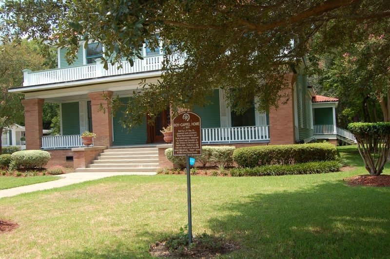
Built by L. P. Roy, Sr., prominent bank president, State Representative and local entrepreneur. Designed by Favrot and Livaudais of New Orleans in the Arts and Crafts style. Features a tile roof and much use of beveled glass throughout. "Sister" . . . — — Map (db m121196) HM
On North Main Street north of West Bon Temps Street, on the left when traveling north.
Site of general store and post office where Sam Bass mailed Solomon Northup's letter to obtain his freedom from being kidnapped into slavery. Northup was a free man of color living in Saratoga, New York and was hired to play violin in Washington, . . . — — Map (db m122414) HM
On North Main Street (State Highway 115) north of Mark Street, on the right when traveling north.
Solomon Northup, a free man of color from New York, was lured
to Washington, D.C. in 1841 and kidnapped into slavery.
Brought to New Orleans, he was sold to spend 12 years as a
slave in Central Louisiana arriving on the Red River in
Alexandria. . . . — — Map (db m120959) HM
On Spring Bayou Road, 1 mile south of Dr. Michel Road.
Spring Bayou in located within the Spring Bayou Wildlife Management Area, which spans more than 12,000 acres in the low-lying , poorly drained Red River backwater system.Spring Bayou is located within Spring Bayou Wildlife Management Area, . . . — — Map (db m117592) HM
On South Washington Street near East Waddil Street, on the right when traveling north.
Founded by Rev. Fr. Jules Janeau in 1869 with worship in a Gothic frame Church. Replaced in 1926 by Msgr. Henry Van de Putten with this Romanesque structure designed by W. T. Nolan. — — Map (db m98023) HM
On West Bon Temps Street, 0.2 miles north of North Monroe Street, on the right when traveling north.
Congregation established in 1881 as a mission from St. James Church in Alexandria. Rev. W.S. Slack was pastor of the church on this site in 1902. — — Map (db m121239) HM
On North Main Street (State Highway 107/115) north of East Mark Street, on the right when traveling north.
Rezin P. Bowie, brother of Alamo hero James Bowie, wrote, “The first Bowie knife was made by myself in the Parish of Avoyelles.” With this knife James killed Norris Wright in the famous Sandbar Fight near Natchez, Miss., Sept. 19, 1827. — — Map (db m98048) HM
On Tunica Drive East (State Highway 1) 0.1 miles north of Medic Drive, on the right when traveling north.
One mile east is the Marksville prehistoric Indian ceremonial center. This site, occupied from 1-400 A.D., was related to the Ohio Hopewell Culture, and was noted for its elaborate trade networks and mortuary ceremonialism. — — Map (db m98269) HM
On Tunica Drive East (State Highway 1) north of Yuroni Trail, on the right when traveling north.
Lands granted to the Tunica tribe by the Spanish government comprise part of the present reservation. The Tunica-Biloxi Tribe is a fusion of the Tunica, Biloxi, Ofo, and Avoyel peoples. — — Map (db m97810) HM
On South Washington Street east of Tunica Drive East (State Highway 1).
Arts and Crafts style home built by Roy Watts and home to Carnot Dupuy for many years. Mr. Dupuy, a pharmacist, was mayor of Marksville in 1920 and also served on the School Board. — — Map (db m103559) HM
On Cottage Street at West Barbin Street, on the right when traveling south on Cottage Street.
A two and one half story Greek Revival frame structure with upper and lower galleries stood here. Built by Edwards on land purchased from Marc Eliche'. Later owned by Judge Aristide Barbin. — — Map (db m98055) HM
On Old Moncla Road near Chauffpied Elmer Road, on the right when traveling north.
Colonized in the late 1700s. Named for Dr. Joseph Thibault Moncla 1806-1883Emigrant of Moncla, France, and husband of Arsene Bordelon. This settlement, on the south bank of the Red River, included a ferry, . . . — — Map (db m138652) HM
Near Bayou Des Glaises Street (State Highway 451) north of Fox Street, on the right when traveling east.
In grateful tribute
to all who served our Country
and
in loving memory of our war dead
Carlton Alexander Medric Armand Elmo Coco Alton Couvillion Horace Dupas Louis L. Lacour Earl Lemoine Euclide Lemoine Roy Lemoine Bernard Mayeux Hubert . . . — — Map (db m98086) WM
On Main Street (State Highway 114) near Gautheir Street, on the left when traveling west.
Site of the organization of the first Corn Club, forerunner of the 4-H clubs, in Louisiana. Organized on Feb. 8, 1908, by V.L. Roy, Avoyelles School Superintendent. Two hundred fifty boys attended first meeting. — — Map (db m98024) HM
On Bayou des Glaises Street (State Highway 4561) 0.2 miles north of Fox Street, on the right when traveling north.
The first church for Catholics in the Moreauville area along Bayou des Glaises was built in 1858 and known as St. Hyacinthe's Mission Chapel that was administered by St. Paul's Church, Mansura. Widow Aimee Joffrion Boyer donated the property on . . . — — Map (db m99181) HM
On State Highway 1, 0.3 miles east of South Wayside Road, on the right when traveling east.
Also known as Norwood's Plantation, fought on May 18, 1864. Last battle of Banks' Red River Campaign. General Richard Taylor's Confederate army failed to prevent Union army crossing Atchafalaya River at Simmesport. — — Map (db m97437) HM
On Business U.S. 171 east of South Pine Street (Louisiana Highway 27), on the right when traveling east.
Center Panel
In 1912 when residents decided to divide Imperial Calcasieu Parish
into several smaller parishes, Beauregard Parish was born. The
people of Beauregard were optimistic about their future, and as . . . — — Map (db m229089) HM
On South Washington Street at West 3rd Street, on the right when traveling north on South Washington Street.
(center panel)
Climbing roses and vine covered trellises, along with flowering plants adorned the yards of the 125 tenant houses that were built by the Hudson Lumber Com0any in 1903. The subsidiary sawmill was built by Long Bell Lumber . . . — — Map (db m109521) HM
On Grabow Road, 0.7 miles west of State Road 3099, on the right when traveling west.
At this site, on July 7, 1912, a violent confrontation occurred between the Galloway Lumber Company and the Brotherhood of Timber Workers. The riot left 4 men dead and an estimated 50 men wounded. It was the defining event in the attempt to . . . — — Map (db m125227) HM
On South Washington Street south of Ronald Reagan Highway (U.S. 190), on the left when traveling south.
Sam Houston Jones (1897 -1978) was born in Merryville and spent his youth in DeRidder. He is the only native of Beauregard Parish ever elected Governor of Louisiana. Jones graduated from DeRidder High School in 1915. He then enrolled at Louisiana . . . — — Map (db m140517) HM
On State Highway 26 at Don Gray Road, on the right when traveling east on State Highway 26.
Built 1919-used as a
school until 1928. Bought
by community families to
be used for cultural
and social activities.
Placed on the National
Register of Historic
Places December 2002. — — Map (db m125177) HM
The gun battle known as the Grabow (or Graybow) Riot marked the violent culmination of the growing animosity between the Brotherhood of Timber Workers (BTW) and the Southern Lumber Operators'
Association (SLOA). News of the shootout spread . . . — — Map (db m229092) HM
On U.S. 190, 0.6 miles north of Hauser Road, on the right when traveling north. Reported missing.
In 1862, when Federal troops captured New Orleans and blockaded the mouth of the Mississippi River, Taylor's army, then in Central Louisiana, retreated from Bank's army and it became necessary to furnish them with supplies. For this purpose a . . . — — Map (db m176941) HM
On Ronald Reagan Highway (U.S. 190) west of Blue Ridge Drive, on the right when traveling east.
Erected in memory of United
States Army Air Force
personnel who lost their
lives in training accidents
at the DeRidder Army
Airport and Gunnery
Range, 1942-45. — — Map (db m124846) HM
Near Old Hoy Cemetery Road, 0.3 miles north of Louisiana Highway 26, on the right when traveling north.
A Hub in the Woods
In a large clearing of virgin pines trees, men built the large logging camp of Hoy around 1910. Hoy was one of many camps established by Long Bell Lumber Company, which operated one of the largest sawmill
systems in the . . . — — Map (db m229079) HM
Center Panel Sugartown Leads the Way
First surveyed as a township in 1807, Sugartown was established in 1816 when some of the first Anglo settlers began to arrive in the region.
Sugartown served as a way station for . . . — — Map (db m225772) HM
On Old Campground Cemetery Road, 0.5 miles east of Pentecostal Church Road (Parish Highway 370).
Main Panel A Waypoint through the Years
Old Campground stands near an ancient ford (a shallow place with good footing where a waterway can be crossed) on Sugar Creek, and the proximity of Old
Campground to this ford is not a coincidence, . . . — — Map (db m189246) HM
On Longville Road (Parish Road 217) east of Cedar Street, on the right when traveling east.
In 1906, the Long Bell Lumber Company of Kansas City,
Missouri, under the leadership of Robert A. Long, began
building a premier sawmill at Longville, Louisiana. The steam
driven sawmill could cut 350,000 feet of lumber per day. Long-
Bell also . . . — — Map (db m140558) HM
On Ronald Reagan Highway (U.S. 190) at State Highway 111, on the right when traveling west on Ronald Reagan Highway.
Portion of historical Atákapa trails connecting their S.E. Texas bands ("Sunset People") to S.W. Louisiana bands ("Sunrise People"), especially the Opelousa band. Composed of six bands, the "Atákapas", a Choctaw name, called themselves . . . — — Map (db m136964) HM
On Hennigan Street, 0.2 miles west of Main Street (Louisiana Route 110), on the left when traveling west.
Main Panel An Outlaw Arrives in Merryville
A rumored fugitive from Texas, Charles "Leather Britches" Smith brought his nasty disposition to Merryville in 1910. He was
a deadly shot. With his two Colt pistols, he could shoot purple martins in . . . — — Map (db m235490) HM
On North Railrod Avenue west of Museum Drive, on the right when traveling west.
Birthplace July 15, 1897 LA Governor (1940-1944) He defeated Louisiana's "Long Machine" and delivered an honest administration. He restored respect for Louisiana. — — Map (db m175163) HM
On Ronald Reagan Highway (U.S. 190) at North Bryan Street, on the right when traveling east on Ronald Reagan Highway.
In the early 1800s members of the Coushatta Indian tribe, led by their chief, Red Shoes, settled in and around the present town of Merryville, where Indian mounds, shards and arrow heads have been found. Being near the Spanish Territory provided . . . — — Map (db m136681) HM
On North Bryan Street at U.S. 190 on North Bryan Street.
Center Panel The Atakapa-Ishak (uh-TAK-uh-paw ee-SHAK) are a band of Indians that inhabited all of southwest Louisiana and southeast Texas for centuries prior to European settlement of the region. The huge
area was inhabited by six bands of . . . — — Map (db m211081) HM
On Old Camp Ground Cemetery Road, 1 mile east of Pentecostal Church Road.
A memorial to the pioneers of Sugartown (early outpost of Southwest Louisiana), whose courage and fortitude helped subdue the historic "Neutral Territory" of the Sabine-Rio Hondo Strip, claimed and contended for by four nations - France, Spain, . . . — — Map (db m124845) HM
Near State Highway 507, 2.7 miles west of State Highway 147, on the right when traveling west.
Facts about the MountainThe mountain was named for James Christopher Driskill. He was born in Hancock County, Georgia, on June 17, 1817. In 1840 he married Eugenia Irwin Walker. In October 1859, Mr. Driskill sold his land in Georgia, and moved . . . — — Map (db m166115) HM
On State Highway 507, 0.8 miles west of State Highway 797, on the right when traveling west.
Near this spot is the trailhead to Driskill Mountain, Louisiana's highest point and the Mt. Zion Presbyterian Church and Cemetery. James Christopher Driskill, the mountain's namesake. was born in Hancock County, Georgia, on June 27, 1817. On October . . . — — Map (db m234596) HM
On Kepler Road (State Highway 507) at Old Sparta Road, on the right when traveling west on Kepler Road.
Founded in 1849 as first parish seat for Bienville Parish. Post office est. 1849. 1st Postmaster J. M. Denson. Incorp. 1852. 1860 pop. Of 250 composed of merchants, craftsmen and professionals. Had two churches, two Masonic Lodges, three private . . . — — Map (db m166144) HM
On State Highway 154, 3 miles south of State Highway 793, on the right when traveling south.
On This Site May 23, 1934 at 9:15 a.m.
The Infamous Outlaws Bonnie Parker and Clyde Barrow
Met Their Demise At The Hands Of These
Dedicated Law Enforcement Officials
Lest we Forget These Brave And
Vigilant Conservators of the . . . — — Map (db m128271) HM
On Main Street (U.S. 80) north of South 2nd Street, on the right when traveling south.
This Is The Location Of Ma Canfield's Cafe Where Bonnie Parker And Clyde Barrow Stopped At 9am On May 23, 1934, Picked Up Sandwiches And Drove Off To Their Deaths 7 Miles Away. — — Map (db m181170) HM
On U.S. 71, 0.2 miles north of State Highway 4, on the right when traveling north.
Nearest point of Federal advance on Shreveport during Civil War. About four miles to southwest near confluence of streams Confederates sank steamer New Falls City which blocked passage of Federal gunboats, April 10, 1864. — — Map (db m109795) HM
On State Highway 9 at Briarwood Road, on the right when traveling south on State Highway 9.
The botanist, artist, author, conservator, and pioneer, Caroline Dormon, was born at Briarwood in Saline, Louisiana on July 19, 1888. Established by Dormon's grandparents, Harietta and Benjamin Sweat, in 1859. Briarwood was originally a cotton . . . — — Map (db m209848) HM
303rd Bombardment Group (H)
Molesworth, England
12 September 1942–11 June 1945
More combat missions (364) than
any other 8AF B-17 Group
Dedicated to all who served
with this highly decorated
group from its activation
3 . . . — — Map (db m105224) HM WM
1942 - 1945
England - France
Belgium - Germany
Dedicated to the memory of the young men that trained at Barksdale and went on to serve with the 344th Bomb Group (M) in World War II.
The 344th Bomb Group led the Ninth Air Force into . . . — — Map (db m109811) WM
A tribute to all
who served in the
34th Bomb Group
April 1944 - June 1945
Mendlesham, England
4th Sqdn - 7th Sqdn
18th Sqdn 391st Sqdn — — Map (db m109807) WM
This WWII unit flew 191 combat missions over Nazi-held Europe from Station No. 174 Sudbury-Suffolk, England between May 1944 and July 1945.
The survivors of the 486th dedicate this memorial to all who served the unit in the cause of freedom . . . — — Map (db m109808) WM
Near Range Road, 0.1 miles north of Shreveport Road.
General Ira C. Eaker was a farm boy from Eden, Texas who became one of history's most famous air commanders. From April 15, 1942 to December 1, 1943 General Eaker commanded VIII Bomber Command (later redesignated Eighth Air Force) from his command . . . — — Map (db m109689) HM WM
Near Range Road, 0.1 miles north of Shreveport Road.
General Joseph James Nazzaro was born and raised in the shadows of the skyscrapers of New York City. Not too many years later, General Nazzaro would soar over the tops of those skyscrapers and go on to command some of this nation's mightiest air . . . — — Map (db m109691) WM
Near Range Road, 0.1 miles north of Shreveport Road.
Lewis Elton Lyle, a native of Pine Bluff, Arkansas and a graduate of Ouachita College, earned his wings in the 41-I class at Brooks Field, Texas. Assigned to the 303rd Bombardment Group upon activation of the 8th Air Force, he and his crew flew his . . . — — Map (db m109687) HM WM
USAF aerial reconnaissance can trace its roots back to the American War between the states, when balloons carried aloft battlefield observers. The invention of the aircraft offered exciting new possibilities. The Wright brothers courted the air . . . — — Map (db m109802) HM WM
On Bodcau Dam Road at Bellevue Cemetery Road, on the left when traveling east on Bodcau Dam Road.
Official burial ground for Bellevue, formerly Bossier Parish seat. At least two judges, four Bossier parish Sheriffs, and twenty-one Confederate soldiers are buried here Bellevue was first called Freedonia, then Society Hill. — — Map (db m181378) HM
On Louisiana Route 157 north of Bodcau Dam Road, on the left when traveling north.
Historic site of Freedonia, where first session of Bossier Parish court was held September 25, 1843: presiding was Judge W.K. Beck. Site later named Society Hill, then Bellevue. First Police Jury meeting was held about two miles northeast on site of . . . — — Map (db m181438) HM
On Burt Boulevard east of State Route 3, on the right when traveling west.
Cornerstone laid July 1, 1910 by members of R.J. Hancock Chapter, U.D.C. Formally unveiled on Tuesday, August 30, 1910, as a monument to the Confederate soldiers of Bossier Parish. — — Map (db m178396) HM
On Bossier Street at Bellevue Street, on the right when traveling south on Bossier Street.
Built in circa 1840 by Alex B. Hughes, the house remained in the Hughes family until its donation to the Bossier Restoration Foundation in 1972. This was the boyhood home of William Clark Hughes who was the Speaker of the Louisiana House of . . . — — Map (db m109778) HM
On Range Road, 0.4 miles north of Shreveport Road, on the right when traveling north.
CMSGT Richard L. Etchberger
Medal of Honor
21 SEP 10
Isaiah 6:8 “I heard the voice of the Lord, saying
Whom shall I send and who will go for us?
Then said I, here am I; send me
The introduction of the B-52 into the Vietnam War . . . — — Map (db m199163) WM
On Range Road, 0.3 miles north of Shreveport Road, on the right when traveling north.
Following World War II, Great Britain realized the importance of maintaining strategic bombers possessing long-range, heavy bomb loads, high speed, high-altitude performance, and able to be based anywhere in the world. To meet this challenge, . . . — — Map (db m199175) HM
On Range Road, 0.2 miles north of Shreveport Road, on the left when traveling north.
The AT-11 was the standard bombing trainer in World War II, responsible for training more than 90% of the more than 45,000 Army Air Force (AAF) bombardiers. The Kansan was one of several military versions of the Beechcraft Model 18 Commercial . . . — — Map (db m199232) HM
On Range Road, 0.2 miles north of Shreveport Road, on the left when traveling north.
The C-45 was the World War II military version of the popular Beechcraft Model 18 commercial light transport. Beechcraft built a total of 4,526 of these aircraft for the Army Air Forces (AAF) between 1939 and 1945 in four versions, the AT-7 . . . — — Map (db m199234) HM
On Range Road, 0.3 miles north of Shreveport Road, on the right when traveling north.
The B-29 was designed in 1940 as an eventual replacement for the B-17 and B-24. Its maiden flight was on September 24, 1942 from Boeing Field in Seattle. After taking delivery in 1943, United States military leadership decided not to employ the B-29 . . . — — Map (db m199178) HM
On Range Road, 0.4 miles north of Shreveport Road, on the right when traveling north.
Since it became operational in 1955, the B-52 has been the main long-range heavy bomber of the Strategic Air Command. It first flew on Apr. 15, 1952. Nearly 750 B-52s were built when production ended in Oct. 1963, of which 170 were -Ds. The -Ds were . . . — — Map (db m199170) HM
On Range Road, 0.5 miles north of Shreveport Road, on the right when traveling north.
Since it became operational in 1955, the B-52 has been the main long-range heavy bomber of the Strategic Air Command. It first flew on Apr. 15, 1952. Nearly 750 B-52s were built when production ended in Oct. 1963, of which 193 were-Gs. The B-52G was . . . — — Map (db m199162) HM
Near Range Road at Shreveport Road, on the right when traveling north.
Based on the Boeing 707 airframe, the KC-135 was the first totally jet powered in-flight refueling aircraft. C-135s served as Air Force One and have been modified into electronic warfare aircraft, weather reconnaissance, airborne command post and . . . — — Map (db m199140) HM
On Range Road, 0.3 miles north of Shreveport Road, on the right when traveling north.
The C-97 was the Army Air Force.cargo/transport version of the B-29. Between 1943 and 1950, 74 Stratofreighters were ordered; the first flight occurred on Nov. 15, 1944. A tanker version (KC-97) was introduced in 1950 using the “flying boom” . . . — — Map (db m199176) HM
Built by Don S. Coleman in 1960. Designed in the mid-century modern style showcasing an iconic wave roof of reinforced concrete and a free span vaulted ceiling. Originally “Holiday Bowl” with 32 lanes. — — Map (db m214288) HM
On Range Road, 0.5 miles north of Shreveport Road, on the right when traveling north.
The U.S. Air Force's first operational supersonic bomber, the B-58, made its initial flight on Nov 11, 1956. In addition to the Hustler's delta wing shape, distinctive features included a sophisticated inertial guidance navigation and bombing . . . — — Map (db m199223) HM
On Range Road, 0.2 miles north of Shreveport Road, on the left when traveling north.
The USAF bought 76 production FB-111As to fill a gap in the strategic bomber force between the time when the Boeing B-52C & F models and Convair B-58As were being phased out in the late 1960's into the early 1970's. The Advanced Supersonic Manned . . . — — Map (db m199186) HM
On Range Road, 0.2 miles north of Shreveport Road, on the left when traveling north.
“We believe peace is at hand”
Oct. 23, 1972
Dr. Henry Kissinger, National Security Advisor to
President Richard Nixon
Beginning in early October thru mid-December of 1972, United States National Security Advisor Dr. Henry Kissinger and North . . . — — Map (db m199181) HM WM
On Range Road, 0.2 miles north of Shreveport Road, on the right when traveling north.
The two-place T-33 jet was designed for training pilots already qualified to fly propeller-driven aircraft. It was developed from the single-seat F-80 fighter by lengthening the fuselage slightly more than three feet to accommodate a second cockpit. . . . — — Map (db m199179) HM
On Range Road, 0.5 miles north of Shreveport Road, on the right when traveling north.
Dedicated in 1999 to
Mr. B-52
Major General William E. Eubank, Jr.
for
outstanding service to the nation
• Flew first B-52 and KC-135 aircraft accepted by the USAF from Boeing
• Commanded 93rd Dome Wing winning Mackay Trophy for first . . . — — Map (db m199143) HM WM
On Range Road, 0.2 miles north of Shreveport Road, on the left when traveling north.
The Martin Titan II was developed at the beginning of the 1960s. A major improvement over the Titan I was an upgraded version of the Aerojet-General LR87 first-stage rocket engine. The engine was capable of producing 430,000 lbs of thrust and burned . . . — — Map (db m199227) HM
On Range Road, 0.4 miles north of Shreveport Road, on the right when traveling north.
The MiG-21F is a short-range day fighter-interceptor and the first major production version of the popular MiG-21 series. It is but one of many versions of this aircraft that have served in the arsenals of many nations around the world. The E-5 . . . — — Map (db m199174) HM
On Range Road, 0.5 miles north of Shreveport Road.
The North American Aviation Corporation AGM-28 Hound Dog was was a supersonic, jet-powered, air-launched cruise missile. The Hound Dog was initially given the designation B-77, later re-designated GAM-77, and finally designated the AGM-28. It was to . . . — — Map (db m199146) HM
On Barksdale Boulevard (State Highway 72) at Monroe Street, on the right when traveling east on Barksdale Boulevard.
Cornerstone laid Nov. 26, 1926. Officially dedicated May 19, 1927. A fine example of the Spanish "Hacienda" style adapted for public buildings. The second floor still contains original jail cells. — — Map (db m109777) HM
On Fillmore Cemetery Road at State Highway 157, on the right when traveling west on Fillmore Cemetery Road.
Located a short distance down this road. Founded 1848 by Fillmore Methodist Church, once located on site. Buried here are Thomas D. Connell, founder of Connell's Cross Roads (now Fillmore), and W.P. Haughton. Also here is O.R. Gelette (1845-1944), . . . — — Map (db m181360) HM
On South Elm Street (Louisiana Route 157) 0.2 miles south of Fox Creek Street, on the right when traveling north.
Built 1883 after earlier house on site burned. Residence of Dr. Paul Lawrence. respected physician, who performed house calls for over 50 years despite the loss of a leg in the Civil War. Haughton was originally called Lawrenceville in his honor. — — Map (db m169679) HM
On Johnson Koran Road, 1 mile north of State Highway 527, on the left when traveling north.
At this site in 1868, Isaac Williams
and thirty other African American
men were arrested and unlawfully
convicted and sentenced to one year
in the penitentiary for holding a
Loyal-League meeting. Four months
later, with the advice and consent . . . — — Map (db m144214) HM
On Louisiana Route 157 north of Davis Road, on the left when traveling north.
Modified dog trot house is example of skills and creativity of early 20th century homes in Bossier Parish. It has one room on south side and three rooms on the north.
Built circa 1927 by Henry McDade for his wife, Artie Lee Patterson McDade and . . . — — Map (db m169361) HM
On Louisiana Route 612 west of Rogers Lane (Louisiana Route 157), on the left when traveling west.
This house was built in stages between 1832 and 1848, and by 1850 was owned by Doctor Abel Skannal. From this house the family controlled five plantations totaling over 8000 acres. Rumors about ghosts are sustained by the fact that Doc Skannal kept . . . — — Map (db m169284) HM
On U.S. 71, 0.3 miles south of Gamble Road, on the right when traveling north.
Built c.1875, was residence of Elam S. Dortch, believed to be the last surviving Confederate veteran residing in Bossier Parish. Moved c.1923 to present site from original location nearer river. Listed in National Register of Historic Places, 1982. — — Map (db m109796) HM
On Gray Street (Louisiana Route 3049) north of Olympia Road, on the right when traveling north.
Grades 1-11 1921-1947
Grades 1-12 1948-1955
Grades 1-8 1956-1969
Dedicated to the Principals, Faculty and Students who made this school such a special part of our lives. This was education as it should be.
Dedicated by the Friends of . . . — — Map (db m175303) HM
On Church Street north of White Street, on the right when traveling north.
The property for Belcher Methodist Church was purchased in 1916 after over two years of fundraising. A white wood frame church was built that same year. In 1954 that structure was raised and a new brick church was built. Several men in the . . . — — Map (db m175189) HM
On Gray Street (State Highway 3049) north of Louisiana Street, on the right when traveling north.
A Caddo mound and village dating between approximately 1450 & 1650 A.D. were located northeast of Belcher. The mound consisted of a series of platforms that contained houses or meeting places for the village leaders. The houses were burned . . . — — Map (db m87132) HM
On Gray Street (State Highway 3049) north of Louisiana Street, on the right when traveling north.
Belcher Presbyterian Church was organized on July 18, 1897, as the Red River Presbyterian Church. The congregation met in a vacant store building on Rush Point Plantation where services were held until 1900, when a one room frame building was . . . — — Map (db m87130) HM
On Louisiana Route 3049 at Belcher River Road, on the right when traveling north on State Route 3049.
A Caddo dugout canoe from the Middle Caddo period (ca. A.D. 1200-1500) was found in the bank of the Red River on Kavanaugh family property near this location in June of 2017 by Jenna Bradley and Robert Cornett. The canoe was recovered from the river . . . — — Map (db m174857) HM
On Dixie Shreveport Road (Louisiana Route 3049) 1 mile north of Louisiana Route 169, on the right when traveling north.
A Caddo Indian dugout canoe dating to the early Caddo period (ca. A.D. 900-1200) was found in the bank of the Red River on the North family property near this location in August of 1983. A section of the canoe was discovered protruding from the . . . — — Map (db m175579) HM
On State Highway 3049 at Cedar Bluff Road, on the right when traveling north on State Highway 3049.
Cedar Bluff Ferry was one of the ferries on the Red River between Bossier and Caddo Parishes in the 19th and early 20th century. It operated until the early 1950s when a bridge was built to the north for Highway 2. It ran from Cedar Bluff in Bossier . . . — — Map (db m87160) HM
On Caddo Street (State Highway 3049) at East Street, on the right when traveling east on Caddo Street.
The First State bank of Belcher was organized in 1913. The present brick building was designed by the architect Edward F. Neild of Shreveport and built in 1924. The First State Bank later became Caddo Trust & Savings Bank the Belcher Masonic Lodge . . . — — Map (db m87128) HM
On Caddo Street west of Line Street, on the right when traveling west.
Built in 1915, the one lane bridge is one of the earliest examples in Louisiana of an all-concrete structure. Unique characteristics give it a coherent, monolithic appearance. The reinforced concrete superstructure consists of a concrete deck on two . . . — — Map (db m175070) HM
On Louisiana Route 3049, 1 mile north of Cedar Bluff Road, on the right when traveling north.
Ca. 1922 a country store was moved from Myrtis, La to this location to serve as the new commissary for the J.W. Lynn Plantation. At it's peak over 300 hundred families lived and worked on the plantation, with the commissary serving as the general . . . — — Map (db m174856) HM
On Gray Street (State Highway 3049) north of Parish Road 136, on the right when traveling north.
During the Louisiana Maneuvers of 1941, the U.S. Army and Air Corps divided itself into two opposing armies for practice for possible war in Europe. Among the noted commanders in the maneuvers, was General George S. Patton. His mechanized armored . . . — — Map (db m87133) HM
On State Highway 3049, 0.2 miles south of Cavett River Road, on the right when traveling north.
The plantation was established in 1914 by James Wiley Lynn with the purchase of property from the Cavett family. The plantation home, the cotton gin and the blacksmith shop were built by Mr. Lynn in 1928. The renovated dogtrot style home, the barn . . . — — Map (db m87159) HM
On Railroad Street (State Highway 3049) at Caddo Street, on the left when traveling north on Railroad Street.
Clyde Connell, an internationally-known artist named for Scotland's River Clyde, was born and raised in a large household in Belcher on the Dixon Plantation. These early life experiences are reflected in her art. A self-taught painter and sculptor, . . . — — Map (db m174932) HM
On Caddo Street (State Highway 3049) east of East Street, on the left when traveling east.
The original house was built in 1899 by Ruben T. Glassell, a planter, and his wife Vyvian. It faced west and had a center hall in the dogtrot style. The house was enlarged about ten years later with the addition of a new roof, interior columns, . . . — — Map (db m175072) HM
On Dixie Shreveport Road (Louisiana Route 3049) south of Louisiana Route 169, on the left when traveling north.
Cornerstone Missionary Baptist Church was started in a house on the back of the Corner Place in Dixie, Louisiana. The first prayer meeting and a revival was held there in late 1889. Led by Rev. Eddie Moore, Pastor. Cornerstone Church congregation . . . — — Map (db m175731) HM
3136 entries matched your criteria. Entries 201 through 300 are listed above. ⊲ Previous 100 — Next 100 ⊳