City of Berkeley Landmark
designated in 1992
Arriving in Berkeley from Massachusetts, Edward Brakenridge bought property that extended to Rose Street for this large Queen Anne-style residence, a stable, and a carriage house. Ira Boynton, like . . . — — Map (db m54512) HM
City of Berkeley Landmark
designated in 1993
Entomologist, naturalist, physicist, and inventor Charles W. Woodworth designed and built this all-redwood house in the Bay Region style. The three-level, seven-bedroom home has a brown shingle . . . — — Map (db m54877) HM
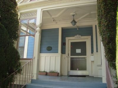
In the 1930s pharmacist and civil rights activist Dr. William Byron
Rumford (1908–1986) served as the first black professional at
Oakland's Highland Hospital. In 1942 he purchased a pharmacy in
Berkeley and, after constructing this . . . — — Map (db m154343) HM
This plaque commemorates the pioneering scientists on this campus
who have made discoveries and advances that are essential to many areas of life science research, forensics, and patient care.
• 1983 - 1991: Discovery and development of the Nobel . . . — — Map (db m154531) HM
The former Salt Evaporation Ponds in front of you have been divided into sections with different levels of saltiness. By studying water conditions, bird use, and prey abundance here, researchers will learn how to create the most opportunities for . . . — — Map (db m206505) HM
In the late 1870’s, inventive Andrew Oliver studied the drawings of Archimedes (287-212 B.C.E) and built these wind driven screw pumps based on the ancient designs.
The wooden blades rotate in the wind, which turns the screw shaft visible under . . . — — Map (db m207726) HM
Long before there were supermarkets, pharmacies and hardware stores, Ohlone people found or made everything they needed from the natural world. They used the roots, stems, leaves, seeds and fruits of plants and trees in the making of food, medicines . . . — — Map (db m204557) HM
This 1891 Victorian style, Italianate house was the residence of Daniel J. Murphy from 1891-1921. He was a prominent Livermore businessman and local government official. As an Alameda County Supervisor, Murphy improved the network of roads and . . . — — Map (db m195505) HM
Dr. McGill was a physician, surgeon, and city public health officer (1902-1914)
Commemorated by the City of Livermore
Historic Preservation Commission
May 2008 — — Map (db m195537) HM
The Laboratory opened September 2, 1952 at this site, initially as a branch of the University of California Radiation Laboratory. Prior to the Lab's opening, this 630-acre parcel was the site of Livermore Naval Air Station, a World War II pilot . . . — — Map (db m25251) HM
Livermorium was created by a collaboration of American and Russian scientists which began in 1989
The first atom of Livermorium was made in 2000
Livermorium was approved internationally on May 30, 2012
May 30th is Livermorium Day
Several . . . — — Map (db m200074) HM
In 1989, scientists from the Lawrence Livermore National Laboratory collaborated with a team at the Flerov Institute in Dubna, Russia, resulting in the creation of elements 114 and 116. On May 30, 2012, the International Union of Pure and Applied . . . — — Map (db m239754) HM
The hydropathic building was one of the facilities located within the Livermore Sanitarium, which existed “for the treatment of neurasthenia, nervous dyspepsia, alcoholism, morphinism, and the functional neuroses.” The building had 12 suites, 20 . . . — — Map (db m198680) HM
Doctor Paul E. Dolan, noted local physician, built St. Paul's Hospital in 1927. A state of the art medical facility, it made a significant contribution to the city's medical services.
Commemorated by the City of Livermore
Historic Preservation . . . — — Map (db m195460) HM
Chemical elements are the building blocks of matter. Elements are composed of atoms that are made of protons, neutrons, and electrons. The atoms of each element have a unique number of protons in their nucleus.
The periodic table identifies the . . . — — Map (db m200077) HM
This marker, dedicated June 21, 2008, celebrates Chabot Space & Science Center's 125 years of inspiring Bay Area star gazers and curious minds of all ages.
From 1883-1915, an observatory on this site housed Chabot's first telescope, "Leah," an . . . — — Map (db m18875) HM
The first recorded visitor to the sulphur springs grotto is Isaac Holmes, a retired U.S. Senator from South Carolina, who reportedly installed a bathtub in Bushy Dell canyon in the early 1860s in order to take alfresco baths for his rheumatism. . . . — — Map (db m72378) HM
Telltale signs of geologic activity surround Grover Hot Springs State Park. Bold granite peaks to the northwest are the work of immense mountain building forces. Old lava flows cover hundreds of square miles to the east, giving the Markleeville area . . . — — Map (db m13239) HM
The William J. Paugh House, also known as Rosewall, is a very pure example of a Gothic Revival House. The style was most popular during the 1840's and 1850's. It was built in the late 1850's by Charles L. Parish, artist, architect and builder. . . . — — Map (db m28067) HM
Medical Offices, Surgery and Hospital of
Dr. Philip Sheridan Goodman. (1867 – 1927).
Office and surgery on ground floor, hospital upstairs.
Miraculous and unconventional, a true
Sutter Creek Character. — — Map (db m29780) HM
Here in Volcano in 1860, miner and amateur astronomer George Madeira built California's first astronomical observatory of record and operated it for two years. Using a three inch refractory telescope he studied sun and moon, stars and planets, and . . . — — Map (db m100583) HM
On the knoll behind this marker, George Madiera built the first amateur astronomical observatory of record in California and there discovered the great comet of 1861 with a three-inch refractor telescope. — — Map (db m100584) HM
The use of wheels to convert flowing or falling water into power began in ancient Greece around the third to the first century B.C. In 1878 Lester Allan Pelton, a carpenter and blacksmith from Nevada City, invented a new design for an impulse water . . . — — Map (db m101590) HM
First American scientist awarded the Nobel Peace Prize (Physics – 1907); Dean of American Optics; Measured velocity of light, ether drift, standard meter, steller diameters. Lived here during childhood. — — Map (db m32818) HM
Dr. John Tennant practiced from this Queen Anne home until his death in 1892. House was later sold to City Attorney James Rogers Sr
circa 1880's — — Map (db m146392) HM
On this site in 1874, Julio Richelieu, bartender, served up the first martini when a miner came into his saloon with a fistful of nuggets and asked for something special. He was served a "Martinez Special." After three or four drinks, however, the . . . — — Map (db m57975) HM
1525 N. Main St. This wood-frame Italianate house was about 30 years old when it was purchased by Dr. Claud Leech, town physician, and his wife, Eva. The first floor served as the medial clinic, the upper floor as the family residence. The house . . . — — Map (db m93822) HM
Mount Diablo has always been a guide and landmark to people far bellow, and so it became a natural location for many radio and transmission towers as well.
As early as 1928, the Standard Oil Company and U.S. Dept. of Commerce jointly . . . — — Map (db m103092) HM
Doctor William Taylor ran a “hospital” in Coloma as early as 1849, and later opened a drug store and pharmacy. While continuing to practice medicine, Doctor Taylor sold a complete line of drugs, extracts, acids, and other chemicals. Later, under . . . — — Map (db m215370) HM
Whose deep concern for the conservation and improvement of our forests led him to establish the Eddy Tree Breeding Station on this site in 1925. His own effort and funds created this oldest forest genetics research institution in the Western . . . — — Map (db m105854) HM
A Viking Son of Norway who fulfilled California’s motto:
“Bring Me Men To Match My Mountains”
For twenty winters from 1858 to 1878 he was the lifeline between Utah Territory across the Sierras, and the new state of California. . . . — — Map (db m12750) HM
Dr William H. Gilliatt was born in Sommerville, Massachusetts He graduated from Aurora College, Illinois and Boston University Medical School. Dr. Gilliatt or “Dr. Bill” as he was generally called, came to Coalinga as a young doctor in . . . — — Map (db m64060) HM
One hundred thirty feet west of this site, Charles Putnam built the first cabin of permanent habitation in what is now Inyo County in August 1861. The building served as a home, trading post, hospital, and “fort” for early settlers, as well as a . . . — — Map (db m2957) HM
Owens Lake is now a Key Migratory Stopover
In the late 1800s, the shoreline of Owens Lake shifted at the hands of people. Even before the City of Los Angeles began diverting water from Owens River, farmers had tapped its tributaries, . . . — — Map (db m221862) HM
Tooth decay was a common and greatly feared ailment in earlier days.
People either had to make do with a painful tooth or find someone to pull it. If a trained dentist could not be found or afforded, a blacksmith or another person who . . . — — Map (db m25929) HM
Until modern medicine, contagious diseases afflicted both young and old and many died at a young age.
In 1875, there were fifteen physicians in Kern County, which had a widely scattered population of approximately 2,700 people. These . . . — — Map (db m25921) HM
Only the most impoverished people sought treatment at a hospital.
The first county hospital in Bakersfield opened its doors to the public in January 1875. The hospital was constructed at 13th and G Streets for $1,400.00. It was a plain . . . — — Map (db m27061) HM
Life in the mid 1800s was difficult. The average age of death in the United States of America was around 40 years old. Disease, accidents and hard work took its toll on people lives.
This exhibit displays artifacts, dating from the . . . — — Map (db m26141) HM
Called a “natural airdrome,” the Rogers Dry Lakebed and surrounding airspace, known as the Air Force Flight Test Center, has been and continues to be the optimum location for “first flights” and validation of high-performance and experimental . . . — — Map (db m152144) HM
Leading the vision and evolution of Air Force rocket propulsion
technology from its earliest days, the Rocket Site's men and
women and their unique research, development, and test facilities
have provided the discoveries, developments, and . . . — — Map (db m153378) HM
China Lake is one of the nation’s premier weapons laboratories. Established in 1943, China Lake supports Naval aviation and warfighter requirements, and will continue to arm the Fleet into the future. The Station conceived of and developed rockets . . . — — Map (db m168225) HM
Originally built by Jean Capdeville as a rooming house, it was later sold to Drs. Madge and Harold Schlotthauer in 1934. It was then used as a hospital until the 1952 earthquake. Although badly damaged, no lives were lost in the hospital. The large . . . — — Map (db m52819) HM
The building at 2424 Main Street was the home of R.G. Reynolds. The "Drug and Prescription Store" pictured here was approximately where the current post office is and belonged to the same Doc Reynolds and Godwin Scudamore. They might have had the . . . — — Map (db m139841) HM
To the memory of Benjamin Davis Wilson, Don Benito, 1811 – 1878, pioneer trapper and settler who came to California in 1841, and in 1864 blazed the trail up this mountain which bears his name. — — Map (db m123037) HM
On this pier in 1926
Albert Abraham Michelson
measured the velocity of light by means of a
beam of light transmitted to
Mount San Antonio
and reflected back to this station. — — Map (db m57274) HM
In 1904, astronomer George Ellery Hale obtained support from the Carnegie Institution of Washington to found the Mount Wilson Solar Observatory. Stellar telescopes were soon added: first the 60-inch, then the 100-inch, when "Solar" was removed . . . — — Map (db m143305) HM
The increased light-grasp of this telescope made possible many notable advances in structural cosmology between 1924 and 1930. They have revised our ideas about the universe in which we live.
One of these advances was that spiral nebulae are . . . — — Map (db m200931) HM
Robert A. Cinader's involvement with the Los Angeles County Fire Department began in 1971 when he filmed a pilot television movie about the county's fledgling paramedic program.
"Emergency" aired in 1972 and ran as a prime time show for five . . . — — Map (db m152460) HM
A portion of the original Spanish landgrant Rancho La Ballona.
The American Legion Post #46 clubhouse was dedicated on August 9, 1930. Contractor Don S. Ely erected the building on this site over the first swimming pool in the area, on . . . — — Map (db m49954) HM
The Hull Building was built on this site in 1925. Dr. Foster Hull, having the interest of his profession at heart, built the most modern medical offices and hospital possible for that time. Early in the 1930's, Louis Freeman acquired the building . . . — — Map (db m49950) HM
Built 1910 for George and
Lucinda Hanawalt by their
sons, Sam, Harvey and J Ross Hanawalt. The house was acquired in 1919 by Dr. and
Mrs. Frank Shirk. Dr. Shirk
maintained a small office
next door. The Shirks lived
here 1919 - 1958. — — Map (db m190954) HM
Dedicated to the employees of Rocketdyne on the tenth anniversary of man’s first lunar landing, July 20, 1979.
A cluster of five Rocketdyne-built F-1 engines lifted the 365-foot-tall Apollo vehicle from Earth, beginning man’s journey to . . . — — Map (db m113129) HM
On 15 November 1950, the SSFL conducted its first official test with a Rocketdyne-designed XLR43-NA-1 large liquid propellant rocket engine, which later became the Redstone engine. Encompassing 2558 acres, 18 large static test stands, 5 component . . . — — Map (db m145228) HM
French Roots
Between 1850 and
1860, French and
French Canadian
immigration to Los
Angeles exceeded that
of all other nations. In
1883, a French-language newspaper,
Le Progrès, began publication. Damien
Marchessault, a . . . — — Map (db m229825) HM
A New Kind of Health Plan
In the 1930s, at the height of the Great Depression, a
young surgeon named Sidney Garfield operated a small
12-bed hospital in the Mojave Desert, treating the
thousands of laborers working on the Colorado . . . — — Map (db m158186) HM
On this site of Birmingham Hospital,
1943-1950, Veterans returning from
World War II were given renewed
confidence and hope by the dedicated
personnel who cared for them. Their legacy of pride and courage
remains here as an incentive for
all . . . — — Map (db m192055) HM
Chester Stock, Ph.D., January 28, 1892 - December 7, 1950. Paleontologist. Chief Curator of Science - Los Angeles County Museum, Chairman of the Division of Geological Sciences - California Institute of Technology who, encouraged by the foresight . . . — — Map (db m51436) HM
Placed high above the towering main entrance, nine enrobed figures stand vigil and greet visitors to LAC+USC General Hospital and half-way up the building, three classically robed figures stand atop columns in window niches.
Completed . . . — — Map (db m145460) HM
Originally planted in 1959 with California natives, the 1.5-acre
garden and greenhouse complex is now a collection of some 1,200
plant species representing many regions and climates from around
the world. In addition to exotic plants, it contains . . . — — Map (db m220283) HM
Built in 2009, Chaparral Hall is named after the most dominant
natural vegetation type in Southern California, and is home to the
Biology Department in the College of Science and Mathematics.
Chaparral Hall's 13 "smart" lecture rooms can seat a . . . — — Map (db m220300) HM
From Inner Spaces To Outer Space
The nation was celebrating
the tenth anniversary of the
Wright Brothers' powered
flight when the State Exposition Building first opened
in Exposition Park in 1913 — a place that
would become an . . . — — Map (db m233940) HM
Hearing The Call And Filling A Need
Any time that Hollywood's stars devote
themselves to raising money for a charity
or a cause, they're following an example
established when the wife of an Oscar-winning actor opened the hearts . . . — — Map (db m229444) HM
USC alumnus.
MS, Aerospace Engineering, 1970.
American Astronaut.
First person to walk on the Moon, July 20, 1969.
"That's one small step for (a) man;
one giant leap for mankind."
A gift of the Trojan League of Los . . . — — Map (db m234066) HM
This area was originally planted with annual and perennial flowers. Roses were tested, conditions proved to be satisfactory, so in 1927 the Rose Garden was established. It contains approximately 15,000 bushes of 145 varieties. The Los Angeles . . . — — Map (db m215943) HM
Wishing On A Star is an eco-kinetic solar sculpture that expresses the human tendency to reach out and explore other possibilities, particularly those that offer long-term sustainability for our planet. Renewable and sustainable energy, using . . . — — Map (db m215955) HM
The mural before you features scientists, philosophers and poets who
believed that our planet, our solar system--indeed, everything in our
universe was (and is) connected. And they saw this connection as
divine. Long before there was a word for . . . — — Map (db m231080) HM
Established by Act of Congress, 1887, as
National Home for Disabled Volunteer
Soldiers. Area includes land from ranchos
Santa Monica y San Vincente and San Jose
de Buenos Ayres. Succeeded by U.S. Veterans
Administration in 1930. Present area . . . — — Map (db m219860) HM
At 10:30 p.m., 29 October 1969, the first ARPANET
message was sent from this UCLA site to the Stanford
Research Institute. Based on packet switching and dynamic
resource allocation, the sharing of information digitally
from this first node . . . — — Map (db m218307) HM
Garvey Ranch, founded by Richard Garvey, Sr.
in 1873, extended from San Gabriel Boulevard
to Atlantic Boulevard.
This building was used
by Mr. Garvey for storage, bunkhouse, and the
pursuit of his interest in astronomical studies. . . . — — Map (db m226801) HM
One of the most outstanding geological features in California, extending for over 650 miles from Point Arena, north of San Francisco, to south of San Gorgonio Pass, between twenty and thirty miles deep and more than a mile wide in some locations. . . . — — Map (db m149749) HM
Arnold O. Beckman developed the first commercially successful
electronic pH meter while a member of the faculty of the
California Institute of Technology. This rugged and portable
“acidimeter,” which had all necessary components housed in . . . — — Map (db m124162) HM
Dedicated to George Ellery Hale, 1868-1938. First Director of this Observatory. Discoverer of solar magnetism. Founder of the Yerkes, Mount Wilson, and
Palomar Observatories, the Astrophysical Journal,
the California Institute of . . . — — Map (db m152855) HM
Hale Solar Laboratory has been designated a National Historic Landmark. This property possesses national significance in commemorating the history of the United States of America. — — Map (db m152145) HM
In memory of Alfred Henry Sturtevant, Geneticist and Naturalist, Professor of Biology at the California Institute of Technology from 1928 to 1970.
These iris resulted from genetic studies he made between 1952 and 1969. — — Map (db m124155) HM
The lower part of this building was constructed as a
hydrodynamics laboratory in 1944 and for 16 years made
many distinguished contributions to knowledge in its
field. In 1960, Aerojet-General Corporation provided
funds for the reconstruction . . . — — Map (db m160767) HM
Near this site, in August 1932, Carl David Anderson photographed the track of a cosmic ray particle in his cloud chamber. He identified this particle as the positron — the first known antiparticle.
Historic Physics Site, Register of . . . — — Map (db m124150) HM
This was once the site of Throop Hall, named after the founder of Throop University, Amos G. Throop. Throop University was founded in 1891 and became the California Institute of Technology in 1920. Built in 1910, Throop Hall was the first . . . — — Map (db m124169) HM
A founder of Physiographic Geology.
Eminent investigator and inspiring teacher.
Professor in Harvard University 1879-1912.
Visiting Professor at California Institute of Technology 1930-1934. — — Map (db m160999) HM
On this site in 1942, the Aerojet Engineering Company founded the
first manufacturing facility for the production of rocket propulsion
systems. This was done under the leadership of Aerojet's first
president, Dr. Theodore von Kármán, . . . — — Map (db m151793) HM
On October 31, 1936 at a site approximately 400 yards to the southeast, in the Arroyo Seco River Bed, a group of students and co-workers from the Guggenheim Aeronautical Laboratory, California Institute of Technology (GALCIT), with the encouragement . . . — — Map (db m118834) HM
Space Flight Operations Facility
has been designated a
National Historic Landmark.
This building possesses national significance
in commemorating the history of the
United States of America. — — Map (db m231405) HM
Terrace Villa Mansion
In 1924, Stillman B. Jamieson (1875-1943), a retired
judge from Chicago, built the last mansion overlooking
Terrace Drive, now known as Terrace Villa. Designed
by Pasadena architect Walter C. Folland . . . — — Map (db m151945) HM
The hills where you stand are a part of one of the world's geological wonders, The San Andreas Rift -- A great fault and earthquake zone.
__________
Because of the movements along this fault zone, the pink and tan colored Punchbowl rocks seen . . . — — Map (db m115197)
First graduate in a class of one from El Monte Schools, 1888. She furthered her education in Los Angeles, since at the time El Monte did not offer higher than 9th grade education. She became a teacher in the Pomona Schools and later a doctor of . . . — — Map (db m152639) HM
Born in South Carolina, Dr. Mayes was one of the first physicians to settle in El Monte (1852). He and several other physicians left New York on horseback in 1847 arriving in New Mexico where for 3 years he served as an Army surgeon. Dr. Mayes . . . — — Map (db m153397) HM
Made in 1864 by Benjamin (Don Benito) Wilson, to bring down timber for his ranch. Up this trail pack burros carried telescope and materials for the first Mt. Wilson Observatory, established by Harvard College in 1889. Orchard Camp (the Half-Way . . . — — Map (db m123036) HM
In 1912, the Board of Trustees hired Los Angeles businessman
Fred C. Nelles as the Superintendent of the Whittier State
School. Under Nelles' tenure the school's focus was shifted from
a correctional philosophy to a philosophy of reform . . . — — Map (db m207801) HM
Lieut. Juan de Ayala of the Royal Spanish Navy sailed through the Golden Gate on Aug. 5, 1775. He commanded the packet-boat San Carlos, which was the first known ship in the waters of San Francisco Bay. On the 13th day of August, Ayala anchored this . . . — — Map (db m69206) HM
Center Panel:
Ayala Cove
Preventing the Spread of Disease
Close your eyes and imagine this cove full of ships and sailors, buildings and noisy machines, doctors, cleaning staff, and nervous travelers hoping to complete their . . . — — Map (db m203263) HM
This brick hospital, built in 1904, was the third hospital to be built for Camp Reynolds. The Army located hospitals treating ill and injured soldiers away from buildings housing healthy troops to prevent the spread of disease and fear. — — Map (db m69249) HM
5639 entries matched your criteria. Entries 201 through 300 are listed above. ⊲ Previous 100 — Next 100 ⊳