On Northwest 140th Street just south of Northwest 148th Place, on the right when traveling north.
In 1822, John J. Triggs was sent as a Methodist missionary to a new mission called Alapaha. This mission extended from south Georgia into parts of north Florida, extending east and west of the Suwanee River. Four missions were established in this . . . — — Map (db m239328) HM
On NW 151st Boulevard near NW 142 Terrace, on the right when traveling east.
Upon completion to Gainesville of the Savannah, Florida and Western Railway in May 1884, citizens from the former county seat at Newnansville were among those who moved to the present site of Alachua which was near the railroad. The city is located . . . — — Map (db m65458) HM
On County Road 241 S near NW 294 Avenue, on the left when traveling south.
A Spanish Mission was established near here within sight of the Santa Fe River about A.D. 1606 by Franciscan missionaries. The river took its name from the mission, as did the modern town of Santa Fe. At one time, Santa Fe de Toloca was said to be . . . — — Map (db m64880) HM
On Main Street, 0 miles north of Northwest 146th Avenue, on the right when traveling north.
In the mid-1800s, Furman Williams moved to Florida with his parents. At age 24, Williams and his brothers came to Newnansville, where they purchased land and acquired interests in local general stores. When the railroad was slated to come to the . . . — — Map (db m233275) HM
On SW 134th Avenue near SW 132nd Lane, on the right when traveling west.
When Europeans first arrived in this area in the 16th century, the inhabitants were Timucuan Indians. In 1774, traveling botanist William Bartram visited Seminole Indians nearby. In the 1850's a town called Deer Hammock was established here, . . . — — Map (db m69979) HM
On Southwest 137th Avenue (West Church Street) at Southwest 170th Street (Gibson Avenue) (Florida Route 241), on the right when traveling west on Southwest 137th Avenue (West Church Street).
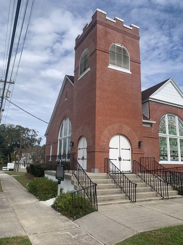
Bethlehem Presbyterian Church was first organized in 1866 at Wacahoota, a farming community southeast of Archer. The early members were pioneer families from South Carolina. Their first pastor, the Rev. William McCormick, founded other pioneer . . . — — Map (db m150976) HM
Near County Road 325 north of Southeast 190th Place, on the left when traveling north.
Friends of Libraries U.S.A. Literary Landmarks Register Cross Creek Beloved home of Marjorie Kinnan Rawlings From 1928 to 1953 Designated by the Marjorie Kinnan Rawlings Society and the Florida Center for the Book on the occasion . . . — — Map (db m185042) HM
Near County Road 325 north of Southeast 190th Place, on the left when traveling north.
Marjorie Kinnan Rawlings House and Farmyard has been designated a National Historic Landmark This site possesses national significance in commemorating the history of the United States of America 2006 National Park Service . . . — — Map (db m185040) HM
On County Road 225, on the right when traveling north.
Evinston Community Store and Post Office
The Evinston community store, originally a warehouse, was built of heart pine in 1884 by W.P. Shettleworth. it was bought by Joseph Wolfenden, who first operated it as a store. The post office, . . . — — Map (db m54240) HM
Near Southeast 15th Street (Camp Ranch Road), 0.4 miles south of Southeast 41st Avenue when traveling south.
Hacienda de la Chua
Organized cattle ranching at the prairie began here in the 1600s. You are standing at the site of the largest ranch in Spanish Florida, Hacienda de Ia Chua (right). Hacienda de la Chua was the main supplier of beef to St. . . . — — Map (db m126488) HM
Near Northwest 34th Street (Florida Route 121) at Northwest 10th Avenue, on the right when traveling north.
(Front)
Hogtown Settlement
Near this site was located Hogtown, one of the earliest settlements in Alachua County. It was originally an Indian village which in 1824 had fourteen inhabitants. Hogtown settlement is also mentioned in . . . — — Map (db m150806) HM
On E. University Avenue, on the right when traveling west.
Present-day Gainesville was the center of a large Spanish cattle ranching industry, founded on the labor of native Timuqua Indians, during the 1600s. LaChua, largest of the ranches, was a Spanish corruption of an Indian word, and in turn was . . . — — Map (db m72916) HM
On NW 6th Street, on the right when traveling north.
This is one of the oldest houses in the city of Gainesville. It was constructed about 1850 by Major James B. Bailey, a prominent citizen of Alachua County. Bailey was a leading proponent of moving the county seat away from Newnansville to a new . . . — — Map (db m55424) HM
On Village Drive at Southwest 2nd Avenue (State Road 26A), on the right when traveling north on Village Drive. Reported permanently removed.
100 yards west is an aboriginal burial mound built ca. A.D. 1000 by Alachua Tradition peoples, ancestors of the Potano Indians who lived in Alachua County in the 16th and 17th centuries. Initially several individuals were buried in a central grave, . . . — — Map (db m134742) HM
On NE 6th Ave at NE 4th St, on the left when traveling east on NE 6th Ave.
William Ruben Thomas House begun by C.W. Chase in 1906, this building was bought and completed in 1910 by Major W.R. Thomas, the house continued as the family’s residence until 1926 when it became part of the Hotel Thomas. Its use by the citizens . . . — — Map (db m150663) HM
On Village Drive south of Southwest 2nd Avenue (State Road 26A), on the right when traveling north.
(side 1)
Timucua Burial Mound
This earthen mound pays tribute to the ancestors of the Timucua Indians who lived and established villages near lakes and other sources of fresh water in north central Florida. Around 950 CE, following . . . — — Map (db m134740) HM
On Southeast Hawthorne Road (State Road 20) 0.1 miles east of Southeast 152nd Street, on the right when traveling west.
Side 1
In 1853, planters Daniel Scott and Daniel Finley of Fairfield, South Carolina, bought 2,664 acres of land here for $6,743, and in 1854 Scott was taxed on 1,400 acres and 30 enslaved people. In 1855, Scott and Finley purchased 54 . . . — — Map (db m110525) HM
On Southeast 221st Street (Old U.S. 301) north of 67th Avenue, on the left when traveling south.
(side 1)
The Moore Hotel is the first hotel and oldest existing business in Hawthorne. In 1882, William Shepard (W.S.) and Virginia McCraw Moore moved to Hawthorne from Braden, Tennessee, and bought a railroad house on Johnson Street to use . . . — — Map (db m150563) HM
On State Road 121 at State Road 235, on the right when traveling north on State Road 121.
Settlement in the LaCrosse area started in the 1840s with the arrival of John Cellon, a young French immigrant. Other early settlers were Thomas Green, Abraham Mott, Richard H. Parker and family, William Scott and Thomas Standley. The town was built . . . — — Map (db m93838) HM
On State Road 121 at State Road 235, on the right when traveling north on State Road 121. Reported permanently removed.
The LaCrosse area was settled before the Civil War. Cotton was the chief crop. John Eli Futch was a cotton buyer who built a warehouse for cotton, a store to serve the growers, and his home near the store. This store became the first post office and . . . — — Map (db m220546) HM
On Pearl Street at Hampton Street, on the right when traveling east on Pearl Street.
The Melrose United Methodist Church was organized in 1868 as the Melrose Methodist Episcopal Church, South. This church building, the first located within the original 1877 plat of Melrose, was constructed out of heart pine by the congregation in . . . — — Map (db m120212) HM
On NE 1st Street (County Road 25A) near N.E. Peach Avenue, on the right when traveling west.
Founded after Spain relinquished Florida to the United States in 1821. Micanopy became the first distinct American
town founded in the new US territory. Originally an Indian trading post, Micanopy was built under the auspices of the
Florida . . . — — Map (db m54271) HM
On Northeast 1st Street (County Route 25A) at Northeast Peach Avenue, on the left when traveling north on Northeast 1st Street. Reported permanently removed.
A Timucua Indian village of the Potano tribe was located near here when the early Spanish Explorer Hernando De Soto led his expedition through the area in 1539. Botanist William Bartram visited Cuscawilla village nearby in 1774. The first permanent . . . — — Map (db m149338) HM
On NE Cholokka Boulevard at Northeast Magnolia Avenue, in the median on NE Cholokka Boulevard.
Moses Elias Levy (1782-1854), a Moroccan born Jewish merchant, came to Florida after its cession from Spain to the United States in 1821. Before his arrival, Levy acquired over 50,000 acres in East Florida. In 1822, Levy began development on . . . — — Map (db m93854) HM
On Southeast Tuscawilla Road, 0.3 miles west of U.S. 441, on the right when traveling west.
Seminoles in Florida
Between 1716 and 1763, under pressure from the colonial powers of Britain and Spain, two groups of Creek Indians from more northerly regions of Spanish La Florida (see map) arrived in the area of present-day Micanopy . . . — — Map (db m150457) HM
Near Northeast Cholokka Boulevard at Northeast Bay Avenue, on the right when traveling north.
This was hand hewn from a Cypress log. It was originally 28” deep. Syrup made from sugar cane juice was stored in this covered trough for family use. — — Map (db m175537) HM
On County Road 234 at County Road 2082, on the left when traveling north on County Road 234.
Colonel Daniel Newnan led a troop of the Georgia militia on a raid into the area in September 1812 in an attempt to annex Florida to the United States in the War of 1812. The raiders engaged a force of Seminole Indians under the command of . . . — — Map (db m54642) HM
On Old Bellamy Road, 0.2 miles west of Northwest 173rd Road Street, on the left when traveling west.
Springhill Methodist Church
Organized-1860,
On the Bellamy Road
Present building erected,
1915
Educational annex a part of
Bland Church
1956
Traxler, Fla.
This community was named
Traxler in the late 1880's
when . . . — — Map (db m172727) HM
On Old Bellamy Road, 0.2 miles west of Northwest 173rd Road Street, on the left when traveling west.
Side 1
Country stores were critical for collecting farm crops and sending them to market. They played an important role in building commerce and establishing credit. The Traxler store was one of several in Alachua County that provided these . . . — — Map (db m197954) HM
Near South Lowder Street south of West Railroad Avenue, on the right when traveling south.
When Alvarado A. Geitgey (pronounced Get-gee) moved to Baker County, he became legendary. A self-made prosperous and shrewd business man purchased large tracts of land in the area and began pecan groves, grape orchards, citrus groves and a dairy . . . — — Map (db m206585) HM
Near South Lowder Street south of West Railroad Avenue, on the right when traveling south.
This building was donated to Heritage Park by the Baker County Board of Public Instruction for the purpose of a school museum. The exterior addition was made possible by a generous donation from Dewey and Lynn Burned in honor of his parents, Jimmy . . . — — Map (db m206912) HM
Near South Lowder Street south of West Railroad Avenue, on the right when traveling south.
In 1822-23, Florida's first Territorial Governor, Andrew Jackson, ordered a string of uniquely crafted block fortresses, with gun ports provided on the log walls, built for the purpose, of protecting pioneer settlers from hostile attacks. Only three . . . — — Map (db m206533) HM
Near South Lowder Street south of West Railroad Avenue, on the right when traveling south.
Once upon a time you could turn off Georgia Road 185 onto the peaceful rural land that led to the Clyde Sands compound, an exhilarating experience, that is, if you like country. On either side of the by-way, as far as the eye could see, was a . . . — — Map (db m206909) HM
On South Lowder Street, 0.1 miles south of W Railroad Avenue.
In honor of
Colonel John (1831-1891) and Clara H. Darby (1838-1880)
Founders of Darbyville
and son, Arthur Morgan and Ida Lee Wolfe Darby
Children: Ada Darby Jones, Susie Darby Marks, John Morgan
Darby, Mira Darby Peek, Mable Lee . . . — — Map (db m206764) HM
Near South Lowder Street south of West Railroad Avenue, on the right when traveling south.
Sadie & Corbett
"I was called Sugar Toes the first 7 years of my life until my Uncle Noah & Cousin Werth came riding up on a mule & asked daddy, "Dennis have you got a name for that boy yet?" My daddy said "Nope"! "Well, I got a name for him, . . . — — Map (db m206676) HM
B- July 17, 1896 — D- May 31, 1964
Graduate of Emory University Medical School, Atlanta, GA.
Organized Florida National Bank of Starke in late 1930’s
Baker County Physician 1920’s through 1940’s
Remembered by . . . — — Map (db m206570) HM
Near South Lowder Street south of West Railroad Avenue, on the right when traveling south.
This water powered windmill, once a source of water supply for the Woodlawn Cemetery-Association, was constructed by A.B. Hart, a pioneer settler (1913) of Hart's Trail Ridge east of McClenny. Mr. Hart's name, followed by the original spelling of . . . — — Map (db m206541) HM
Near South Lowder Street, 0.1 miles south of W Railroad Avenue.
To honor of our 5th g/g/father
Elisha Greene, Sr. 1790 - 1875
who arrived with the first wagon train of settlers
Baker County 1832. Settled on Greene’s Creek
south of Sanderson. Father of 19 children
1 - Wife Elizabeth . . . — — Map (db m206820) HM
On South Lowder Street, 0.1 miles south of W Railroad Avenue.
Elisha Greene arrived in Baker County on Christmas Day in 1830, leading the first wagon train of pioneer settlers.
Acting as advance scouts were William and Mose Barber, and other men acting as scouts.
Others traveling in the train were the . . . — — Map (db m206950) HM
On South Lowder Street, 0.1 miles south of W Railroad Avenue.
In honor of our Garrett Family
Pioneer settlers of North Baker County - Macedonia Area
William “Bill” (1841-1927) Co. D 1st FL Calvary CSA
and Henrietta Hogan Garrett (1855-1934)
Frank (1873) Lewis (1875) Rose (1877) . . . — — Map (db m206811) HM
Near Lowder Street just south of Railroad Avenue, on the right when traveling south.
Harold and Fay Matthews Milton's exceptional lives probably made the greatest impact on the development of Baker County's educational and social advancement more so than any other couple of their era of time. Modest in nature, their achievements . . . — — Map (db m206544) HM
Near South Lowder Street near West Railroad Avenue.
Ida Estelle Corbett born September 8, 1860 was the daughter of Charles C. Corbett and his wite Zilphia Crowningshield, natives of Vermont. A stone cutter and funeral director by trade, Charles, moved his family to the area now known as Baker County . . . — — Map (db m206911) HM
On South Lowder Street, 0.1 miles south of W Railroad Avenue.
Proud to be a Baker County Burnsed Descendant
Honoring
James M. Burnsed
Builder of the Burnsed Block House (Mid- 1830s)
and Fort Monica
Served in 1860s as Baker County Sheriff — — Map (db m206758) HM
Near South Lowder Street south of West Railroad Avenue, on the right when traveling south.
Lula Thrift, daughter of John Newton (born 1851) and Sally (Arnold) Sands (born1861) in the Georgia Bend Area stands in front of the home her husband Nathan Thrift built for her in 1919. At a cost of $25 the lumber was hauled from the sawmill by . . . — — Map (db m206543) HM
Near South Lowder Street, 0.1 miles south of W Railroad Avenue.
Interview 1993
Olustee Friends A.G. St. Johns and Vonceil (Dobson-Fraser) Alvarez
Introduction: Olustee was once a fort during Florida's territorial days as well as a Methodist sanctuary mission. It was once a bustling, busy . . . — — Map (db m206757) HM
On South Lowder Street, 0.1 miles south of W Railroad Avenue.
Otis March 21, 1917 - February 12, 2001
Mattie May 21, 1920 -
Otis Canady was born south of Moniac, the only child of Aaron & Rosa Mae (Rhoden) Canady. Otis fell in love with Mattie, the daughter of Thomas & Mary (Thrift) Crews . . . — — Map (db m206629) HM
Near Lowder Street just south of Railroad Avenue, on the right when traveling south.
Walter Monroe Turner 1856-1931
Son of Charles and Martha (Fraker) Turner
Husband of Lillian Elizabeth Sessions 1862-1929
Walter Monroe Turner was Postmaster in Macclenny for 18 years. He and his wife, Lillian reared four sons and two . . . — — Map (db m206608) HM
Near Interstate 10 at milepost 318,, 0.6 miles west of 17 Mile Camp Road, on the right when traveling east.
Did you know the first people in North Florida lived here 10,000 years ago?1562
Timucuans
The Timucuans were the Native Floridians living in north and central Florida when the Europeans arrived in 1562. Powerful and . . . — — Map (db m159960) HM
On Grace Avenue at West 10th Street, on the left when traveling north on Grace Avenue.
This house at 941 Grace Avenue was built by Maude and Earle Thompson in 1924. The couple lived here with their three children who retained possession of the house until 2008. The Thompson family were among the first citizens of Panama City and . . . — — Map (db m245298) HM
On West 10th Street at Beck Avenue, on the right when traveling east on West 10th Street.
When the Spanish passed through between the years 1516 and 1558, this area was inhabited seasonally by the Chatot and Yuchi Native American tribes. Shortly after contact, the Chatot became extinct (as did more than 90% of Florida native . . . — — Map (db m245641) HM
On Harmon Avenue at East Second Place, on the right when traveling north on Harmon Avenue.
This house was built in 1908 by Miles Lampkin "Lamp" and wife Mary Honora "Nora" Purcell Harmon. "Lamp", born in 1871, was the son of original settlers Turner Hunt and Nancy Harmon. "Lamp" was one of the thirty one qualified voters that signed the . . . — — Map (db m245197) HM
On East Beach Drive, 0.1 miles east of East First Court, on the left when traveling east.
This is the oldest known existing residence in the Cove. It was built about 1867 by Wiliam & Martha Farley who brought their family to the bay from Jackson County shortly after the close of the Civil War. Farley also planted a large grove of orange . . . — — Map (db m245154) HM
On Pitts Avenue, 0.1 miles south of Aster Street, on the right when traveling south.
Loftin’s Ferry, on Pitts Avenue, which later became Parker, was an important part of the major land route called the “Military Road” that ran from Apalachicola through St. Joseph to Marianna and beyond. This road, constructed from 1836 . . . — — Map (db m42114) HM
On West Call Street (State Road 230) at North Temple Street (U.S. 301) on West Call Street.
On December 6, 1861, Gov. John Milton signed a law changing the name of New River County to Bradford County. The Legislature had passed the law in honor of Captain Richard G. Bradford of Madison who was killed October 9, 1861, in the Battle of Santa . . . — — Map (db m15316) HM
On Lighthouse Road north of Control Tower Road, on the left when traveling north.
When the Lighthouse was moved to this site in 1894, the Head Keeper's cottage, the First Assistant Keeper's cottage, and one storage building were also moved. Soon after another storage building and a cottage for the Second Assistant Keeper were . . . — — Map (db m217571) HM
On Lighthouse Road north of Control Tower Road, on the left when traveling north.
The earliest evidence of human habitation on Cape Canaveral dates back about 6,000 years. Descendants of these first humans, the Ais, inhabited Cape Canaveral along with the nearby islands and the mainland.
There are 95 recorded sites within the . . . — — Map (db m217573) HM
On Center Street at Sevilla Court, in the median on Center Street.
Before modern construction a complex of six burial mounds occupied this location. They were built by the ancestors of the prehistoric Ais tribe, a group who occupied the Cape Canaveral area at the time of European contact. Based on pottery styles . . . — — Map (db m243353) HM
On Lighthouse Road north of Control Tower Road, on the left when traveling north.
Beginnings of Settlement
In the 1500s European explorers, slavers and missionaries first came to Cape Canaveral. Here they found a Native American population which had disappeared by 1730. The area remained sparsely populated until a . . . — — Map (db m217567) HM
Near Dave Nisbet Drive, 0.2 miles west of George J. King Boulevard, on the right when traveling west.
Port Canaveral began as a small oil and fishing port. Today, the first-class, deep-water harbor can serve import, export and other industries. Through the years, generations of fishing families have taken their daily catch to market. Some of the . . . — — Map (db m164411) HM
Near Dave Nisbet Drive, 0.2 miles west of George J. King Boulevard, on the right when traveling west.
Titusville is the oldest community on the Indian River. After the Civil War, Titusville went on to spur the region’s transportation, business and shopping growth.
Buildings in the historic area date from 1895 to 1926, when the Florida Land . . . — — Map (db m164440) HM
On Indian River Drive (County Road 515) 0.1 miles south of Briarwood Lane, on the left when traveling north.
Known as City Point, this area was settled shortly after the Civil War by Confederate veterans, citrus grove workers, northern winter residents, and consumptives seeking a healthy climate. By early 1885, a board of trustees was formed consisting of . . . — — Map (db m203571) HM
On Delannoy Avenue north of Church Street, on the right when traveling north.
On October 31, 1916, citrus grower and inventor Edward Postell Porcher and wife Byrnina Peck Porcher, moved into what was the grandest house in Cocoa. The house is a unique example of Neo-Classical Revival Style architecture interpreted in coquina . . . — — Map (db m112182) HM
On West King Street (State Road 520) west of South Cocoa Boulevard (U.S. 1), on the right when traveling west.
One half mile to the west ran the Hernandez Trail used during the Seminole War. It connected forts along the East Coast to Ft. Dallas in Miami and across from Ft. Pierce and Ft. Capron to Ft. Brooke near Tampa. Brig. General Joseph M. Hernandez, . . . — — Map (db m72606) HM
On West City Avenue (U.S. 1), on the right when traveling north.
Atley Bensen paid $1,200 for the precut yellow pine lumber which arrived by riverboat from Jacksonville in 1916, to build this house for his wife Clara Christensen. The Bensen brothers married the Christensen sisters, both pioneer families of Grant. . . . — — Map (db m55099) HM
On New Haven Avenue at Melbourne Court, on the right when traveling east on New Haven Avenue.
Many acres in this area were originally owned by Peter Wright a black man and one of the first settlers of this area. He sold his property to Thomas Mason, an English recluse, who later sold the property to Richard W. Goode for $110.
The . . . — — Map (db m50309) HM
On Highland Avenue, 0.1 miles north of Eau Gallie Boulevard (State Road 518), on the right when traveling north.
Lansing Gleason, a descendant of the pioneer Gleason family, recalled that downtown Eau Gallie had numerous fish houses, each with a barrel of whiskey set up at holiday times. A tin cup was provided on a help yourself basis. Things got pretty rowdy . . . — — Map (db m69035) HM
On Highland Avenue north of Creel Street, on the left when traveling north.
This home was built around 1914 for Francina Houston Hancock, a descendant of Eau Gallie's founding family, the Houston's.
In later years, Dr. W. J. Creel and his family bought the house and lived in it until his death in 1970. the Creel's, who . . . — — Map (db m223462) HM
On Young Street at Sunny Point Drive, on the left when traveling east on Young Street. Reported missing.
This house was built prior to 1900 by Gen. John B. Castleman, a veteran of the Civil War and the Spanish-American War. Gen. Castleman, from Louisville, KY., used this as his winter home for many years.
The General was active in political and . . . — — Map (db m235880) HM
On WH Jackson Street east of South Grant Street, on the left when traveling east.
This long-lost cemetery was uncovered in 1980 when area residents pruned back the dense undergrowth and cleared trash to find two tombstones: those of Alice Chambers who died in 1905 and John H. Whitfield, who died in 1901. A few months later, Boy . . . — — Map (db m234908) HM
On Pineapple Avenue, 0.1 miles north of State Road 518, on the left when traveling north.
In 1880 about 200 people lived in the cities of Eau Gallie and Melbourne. Eau Gallie's population in 1886 was 50. By 1890 the combined population in and around the two settlements was 374, of which 187 actually lived within the two communities. . . . — — Map (db m49123) HM
The exact year the Roesch house was built is unknown. It was probably constructed sometime after 1892. It was constructed by William Russell Roesch. Roesch was made city treasurer of Eau Gallie in 1887. Roesch was also mayor of Eau Gallie numerous . . . — — Map (db m49136) HM
On Houston Street, on the right when traveling south.
The first hickory log cabin built by John C. Houston, original settler of Eau Gallie, was erected in this area. Houston came here in 1859 with his older sons and 10 slaves. He had served in the U.S. Army during the Seminole Indian wars and had been . . . — — Map (db m49240) HM
On East Melbourne Avenue west of Oak Street, on the right when traveling east.
Richard W. Goode, wife Jessie Goode and three small children arrived in the area of Crane Creek in 1877. They came here from Evanston, Illinois.
Goode explored the area, on foot and by boat, while his family remained in the small settlement of . . . — — Map (db m73132) HM
Near West New Haven Avenue (U.S. 192) at McClain Drive, on the right when traveling west.
The Hernandez-Capron Trail parallels I-95 here in Brevard County. Laid out in 1838 by U.S. Army during Second Seminole war, it linked King's Road in St. Augustine and forts along St. John's River with Ft. Capron, 4 mi. north of present Ft. Pierce. . . . — — Map (db m75839) HM
Near Murrell Road, 0.6 miles south of North Wickham Road, on the left when traveling south.
"Nothing occurred to disturb the quiet of the night, except the wolves in the neighboring forest responding howl for howl…"
—Journal of Jacob Rhett Mott, 1838
By the 19th century, American settlements along Florida's . . . — — Map (db m131066) HM
James Wadsworth Rossetter, Sr., came to Eau Gallie in 1902. He purchased this property in 1903. The house was built before the War Between the States and is on the former site of the Houston family's slave quarters. One member of that pioneer . . . — — Map (db m48975) HM
On Pineapple Avenue at Law Street, on the left when traveling south on Pineapple Avenue.
The William H. Gleason House was built around 1884 by William Henry Gleason (c. 1830-1902) and his wife Sarah Griffin Gleason. Gleason came to Florida in 1866 with his wife and two sons from Eau Claire, Wisconsin, and settled in Dade County. In . . . — — Map (db m63911) HM
On Highland Avenue at Shady Lane, on the right when traveling south on Highland Avenue.
The two large oak trees that lent their presence to the naming of this house have been damaged and subsequently cut down because of a windstorm. The house has significant history because it was built in the early part of the twentieth century for a . . . — — Map (db m49280) HM
Near Sunny Point Drive south of Young Street, on the left when traveling south.
This home was started in Dec. 1915, for the S.T. Ballard family, owners of the Ballard Flour Co.
Ginter Brothers had the construction contract and it was said the house cost $40,000 to build.
The Ballards were from Louisville, KY., and . . . — — Map (db m235640) HM
On Riverside Drive at Ocean Avenue, on the right when traveling south on Riverside Drive.
Constructed 1889
Restored 1985
Originally built by the Melbourne and Atlantic Railroad company, this pier was the gateway to the barrier island. A "Port Facility" for tourists, residents, freight, and mail, it supported a standard gauge . . . — — Map (db m53167) HM
On Ocean Avenue, on the right when traveling west.
Constructed on this site in 1888, Myrtle Cottage was built by Mrs. Hannah Cummings and her daughter Grace, and was the first house in the area known as Melbourne Beach. The house's construction was made difficult by the lack of roads or docks, and . . . — — Map (db m52569) HM
This building was constructed in 1908 facing the Indian River Lagoon in the area now know as Ryckman Park in Melbourne Beach. It originally held offices of the Melbourne Beach Improvement Company. The officers, Capt. Rufus Beaujean, son Donald . . . — — Map (db m53166) HM
On State Road A1A at Old Florida Trail, on the left when traveling north on State Road A1A.
Under the United States Government Homestead Act of 1862, brothers Robert Toombs Smith and Charley Smith laid claim to 158.79 acres on Mullet Creek in 1887. They discovered the property while searching the Indian River Lagoon shoreline by sailboat . . . — — Map (db m102830) HM
On Ocean Aveune east of Riverside Drive, on the left when traveling west.
One of the first homes in Melbourne Beach, the Ryckman House was built in 1890 for Jacob Fox by Captain Rufus W. Beaujean. Both men were original investors in the Melbourne Beach Company, later named the Melbourne Beach Improvement Company. The . . . — — Map (db m93164) HM
On South Tropical Trail (County Road 3) at Crooked Mile Road, on the right when traveling south on South Tropical Trail.
Georgianna United Methodist Church was built in the community of Georgiana on Merritt's Island in 1886. The ringing of the church bell still marks the beginning of worship as it has for many decades. Franklin C. Allen, Jr., a local homesteader, . . . — — Map (db m102267) HM
On Barge Canal Circle, 1 mile north of Marine Harbor Dr, on the left when traveling north.
Indianola Pioneer cemetery is the final resting place of early white settlers who carved homesteads out of the lush growth of the Florida peninsula. It was created on November 4, 1898, when Thomas H Sanders and his wife, Mary recognized that the . . . — — Map (db m240075) HM
Near North Tropical Trail at Possom End Road, on the left when traveling north.
The Sams family came to Brevard County from South Carolina in 1875 to take advantage of the 1860 Homestead Act. The family consisted of John Hanahan Sams, his wife Sarah, their five children, John's brother William Sams, and his sister, Catherine . . . — — Map (db m176325) HM
On North Tropical Trail at Pioneer Road, on the left when traveling north on North Tropical Trail.
In 1868, the Field family landed on Merritt Island to start a new life. A year later, much of the family returned to Macon, Georgia, but the two eldest brothers John R. (J.R.) and Samuel J. (Sam) Field remained. Using the Homestead Act of 1862, they . . . — — Map (db m140801) HM
On North Tropical Trail, 0.1 miles south of Sawyer Avenue, on the right when traveling north.
Edwin Dennis Sawyer (1874-1964) was born in the Bahamas, the second child of freed slave Alfred Sawyer. From age 18-25, Dennis worked on a ship and then in Ft. Pierce as a fisherman. In 1898, after moving to Cocoa, he married Rebecca Dallas. The . . . — — Map (db m192603) HM
On Sykes Creek Parkway at Old Audubon Road, on the right when traveling south on Sykes Creek Parkway.
The Ais were one of the most influential and powerful tribes in Florida when Spanish Army Lt. Alvaro Mexia mapped Ulumay Lagoon in 1605. He wrote in his diary “Here is the town of Ulumay, the first one of the province of Ais. In back of and . . . — — Map (db m72602) HM
On Old Dixie Highway just south of Diamond Road, on the left when traveling south.
Established in 1869, this is the oldest cemetery on Florida's lower East Coast. The oldest portion is located in the front center section, evidenced by the southeasterly positioning of the tombstones. Tom Johnson Cockshutt (1841-1917), who arrived . . . — — Map (db m101404) HM
On Old Dixie Highway at Diamond Road, on the left when traveling south on Old Dixie Highway.
In the early 1900s, a two acre parcel of land north of LaGrange Community Church and Cemetery was given to the Mims colored community for a cemetery. Earliest marked graves are dated 1903; many are unmarked. In the 1800s both blacks and whites . . . — — Map (db m101403) HM
Near Freedom Avenue, 0.3 miles south of Parker Street, on the right when traveling south.
On November 7, 1861, Union forces attacked two Confederate forts and the Sea Islands of South Carolina near Port Royal. “The Battle of Port Royal” later drove Confederate forces to retreat to the mainland. One island, Hilton Head Island, immediately . . . — — Map (db m178135) HM
On Rockledge Drive (State Road 515) 0.2 miles south of Barton Avenue, on the right when traveling south.
This house is one of the last remaining examples of Queen Ann architecture in the area. The tall proportions, a variety of surface textures and the irregularity of plan are representative of this style. One of the most predominant characteristics is . . . — — Map (db m102297) HM
On Rockledge Drive at Valencia Road, on the right when traveling south on Rockledge Drive.
The Valencia Historic District was developed during the Florida Land Boom of the 1920s. The Valencia Homes Company was formed in 1924 by local businessmen C. Sweet Smith, Charles D. Smith, L. S. Andrews and Horace R. Bruen. The company acquired a . . . — — Map (db m70298) HM
On South Washington Avenue (U.S. 1) north of Julia Street, on the right when traveling north.
(Successor to Julius Kline's Dry Goods Store)
1892 - 1910
Julius Kline established his dry goods and clothing business around 1892. Destroyed by the 1895 city fire, Kline reopened his business in the adjoining building to the north. In 1902 he . . . — — Map (db m197071) HM
Near S. Washington Avenue (U.S. 1) at Pine Street.
Leroy "Roy" Carpenter was born in 1903 at New Smyrna Beach and moved to Titusville with his parents in 1915. He married Titusville native Grace Morgan in 1925 and they raised
five children, Roy Jr., Merle Ann (Nidy), Jean (Sanders), Walter and . . . — — Map (db m196037) HM
On Courtenay Parkway North (State Road 3) 0.3 miles north of Biolab Road, on the left when traveling north.
Indian River oranges, one of Florida's most outstanding products were developed in the 19th century by Douglas Dummett. The Dummett family immigrated from the Barbados in 1807. By 1825, Thomas Dummett had acquired sugar plantations on the east . . . — — Map (db m125643) HM
On South Washington Avenue (U.S. 1) at Main Street, on the right when traveling north on South Washington Avenue.
The first commercial building on this site, later destroyed in the fire of 1895, was a wood frame structure that housed Brady Bros, Groceries. In 1914, J.E. Easterly built this existing building, #301 for E L. Brady who soon rented it to the . . . — — Map (db m197115) HM
On South Washington Avenue (U.S. 1) at Julia Street, on the right when traveling north on South Washington Avenue.
This hardware business was started in 1886 by a 21 year old Ohio man, Frank T. Budge and his partner, Felix G, Fuckabay. Huckabay & Budge Hardware was located in a small building, previously the express office, located on the north side of Main . . . — — Map (db m197026) HM
1260 entries matched your criteria. The first 100 are listed above. Next 100 ⊳