By Tim Fillmon, January 3, 2024
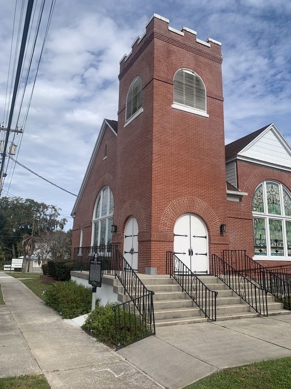
Alachua Methodist Church
GEOGRAPHIC SORT Title Sort Marker Number Sort Marker Number Sort N Marker Number Sort T Publication Order Sort Publication Order Sort A Erected Year Sort Most Viewed Sort Most Recent-Interest Sort Most Recently Changed Sort SEE FAQ #33 FOR DESCRIPTIONS
On Northwest 140th Street just south of Northwest 148th Place, on the right when traveling north.
On NW 151st Boulevard near NW 142 Terrace, on the right when traveling east.
On County Road 241 S near NW 294 Avenue, on the left when traveling south.
On Main Street, 0 miles north of Northwest 146th Avenue, on the right when traveling north.
On SW 134th Avenue near SW 132nd Lane, on the right when traveling west.
On Southwest 137th Avenue (West Church Street) at Southwest 170th Street (Gibson Avenue) (Florida Route 241), on the right when traveling west on Southwest 137th Avenue (West Church Street).
Near County Road 325 north of Southeast 190th Place, on the left when traveling north.
Near County Road 325 north of Southeast 190th Place, on the left when traveling north.
On County Road 225, on the right when traveling north.
Near Southeast 15th Street (Camp Ranch Road), 0.4 miles south of Southeast 41st Avenue when traveling south.
Near Northwest 34th Street (Florida Route 121) at Northwest 10th Avenue, on the right when traveling north.
On E. University Avenue, on the right when traveling west.
On NW 6th Street, on the right when traveling north.
On Village Drive at Southwest 2nd Avenue (State Road 26A), on the right when traveling north on Village Drive. Reported permanently removed.
On NE 6th Ave at NE 4th St, on the left when traveling east on NE 6th Ave.
Paid Advertisement
On Village Drive south of Southwest 2nd Avenue (State Road 26A), on the right when traveling north.
On Southeast Hawthorne Road (State Road 20) 0.1 miles east of Southeast 152nd Street, on the right when traveling west.
On Southeast 221st Street (Old U.S. 301) north of 67th Avenue, on the left when traveling south.
On State Road 121 at State Road 235, on the right when traveling north on State Road 121.
On State Road 121 at State Road 235, on the right when traveling north on State Road 121. Reported permanently removed.
On Pearl Street at Hampton Street, on the right when traveling east on Pearl Street.
On NE 1st Street (County Road 25A) near N.E. Peach Avenue, on the right when traveling west.
On Northeast 1st Street (County Route 25A) at Northeast Peach Avenue, on the left when traveling north on Northeast 1st Street. Reported permanently removed.
On NE Cholokka Boulevard at Northeast Magnolia Avenue, in the median on NE Cholokka Boulevard.
On Southeast Tuscawilla Road, 0.3 miles west of U.S. 441, on the right when traveling west.
Near Northeast Cholokka Boulevard at Northeast Bay Avenue, on the right when traveling north.
On County Road 234 at County Road 2082, on the left when traveling north on County Road 234.
On Old Bellamy Road, 0.2 miles west of Northwest 173rd Road Street, on the left when traveling west.
On Old Bellamy Road, 0.2 miles west of Northwest 173rd Road Street, on the left when traveling west.
Near South Lowder Street south of West Railroad Avenue, on the right when traveling south.
Near South Lowder Street south of West Railroad Avenue, on the right when traveling south.
Paid Advertisement
Near South Lowder Street south of West Railroad Avenue, on the right when traveling south.
Near South Lowder Street south of West Railroad Avenue, on the right when traveling south.
On South Lowder Street, 0.1 miles south of W Railroad Avenue.
Near South Lowder Street south of West Railroad Avenue, on the right when traveling south.
Near South Lowder Street near W Railroad Avenue.
Near South Lowder Street south of West Railroad Avenue, on the right when traveling south.
Near South Lowder Street, 0.1 miles south of W Railroad Avenue.
On South Lowder Street, 0.1 miles south of W Railroad Avenue.
On South Lowder Street, 0.1 miles south of W Railroad Avenue.
Near Lowder Street just south of Railroad Avenue, on the right when traveling south.
Near South Lowder Street near West Railroad Avenue.
On South Lowder Street, 0.1 miles south of W Railroad Avenue.
Near South Lowder Street south of West Railroad Avenue, on the right when traveling south.
Near South Lowder Street, 0.1 miles south of W Railroad Avenue.
On South Lowder Street, 0.1 miles south of W Railroad Avenue.
Near Lowder Street just south of Railroad Avenue, on the right when traveling south.
Paid Advertisement
Near Interstate 10 at milepost 318,, 0.6 miles west of 17 Mile Camp Road, on the right when traveling east.
On Grace Avenue at West 10th Street, on the left when traveling north on Grace Avenue.
On West 10th Street at Beck Avenue, on the right when traveling east on West 10th Street.
On Harmon Avenue at East Second Place, on the right when traveling north on Harmon Avenue.
On East Beach Drive, 0.1 miles east of East First Court, on the left when traveling east.
On Pitts Avenue, 0.1 miles south of Aster Street, on the right when traveling south.
On West Call Street (State Road 230) at North Temple Street (U.S. 301) on West Call Street.
On Lighthouse Road north of Control Tower Road, on the left when traveling north.
On Lighthouse Road north of Control Tower Road, on the left when traveling north.
On Center Street at Sevilla Court, in the median on Center Street.
On Lighthouse Road north of Control Tower Road, on the left when traveling north.
Near Dave Nisbet Drive, 0.2 miles west of George J. King Boulevard, on the right when traveling west.
Near Dave Nisbet Drive, 0.2 miles west of George J. King Boulevard, on the right when traveling west.
On Indian River Drive (County Road 515) 0.1 miles south of Briarwood Lane, on the left when traveling north.
On Delannoy Avenue north of Church Street, on the right when traveling north.
On West King Street (State Road 520) west of South Cocoa Boulevard (U.S. 1), on the right when traveling west.
Paid Advertisement
On West City Avenue (U.S. 1), on the right when traveling north.
On New Haven Avenue at Melbourne Court, on the right when traveling east on New Haven Avenue.
On Highland Avenue, 0.1 miles north of Eau Gallie Boulevard (State Road 518), on the right when traveling north.
On Highland Avenue north of Creel Street, on the left when traveling north.
On Young Street at Sunny Point Drive, on the left when traveling east on Young Street. Reported missing.
On WH Jackson Street east of South Grant Street, on the left when traveling east.
On Pineapple Avenue, 0.1 miles north of State Road 518, on the left when traveling north.
On Houston Street, on the right when traveling south.
On East Melbourne Avenue west of Oak Street, on the right when traveling east.
Near West New Haven Avenue (U.S. 192) at McClain Drive, on the right when traveling west.
Near Murrell Road, 0.6 miles south of North Wickham Road, on the left when traveling south.
On Highland Avenue, 0.1 miles State Road 518.
On Pineapple Avenue at Law Street, on the left when traveling south on Pineapple Avenue.
On Highland Avenue at Shady Lane, on the right when traveling south on Highland Avenue.
Near Sunny Point Drive south of Young Street, on the left when traveling south.
Paid Advertisement
On Riverside Drive at Ocean Avenue, on the right when traveling south on Riverside Drive.
On Ocean Avenue, on the right when traveling west.
On Oak Street, on the left when traveling south.
On State Road A1A at Old Florida Trail, on the left when traveling north on State Road A1A.
On Ocean Aveune east of Riverside Drive, on the left when traveling west.
On South Tropical Trail (County Road 3) at Crooked Mile Road, on the right when traveling south on South Tropical Trail.
On Barge Canal Circle, 1 mile north of Marine Harbor Dr, on the left when traveling north.
Near North Tropical Trail at Possom End Road, on the left when traveling north.
On North Tropical Trail at Pioneer Road, on the left when traveling north on North Tropical Trail.
On North Tropical Trail, 0.1 miles south of Sawyer Avenue, on the right when traveling north.
On Sykes Creek Parkway at Old Audubon Road, on the right when traveling south on Sykes Creek Parkway.
On Old Dixie Highway just south of Diamond Road, on the left when traveling south.
On Old Dixie Highway at Diamond Road, on the left when traveling south on Old Dixie Highway.
Near Freedom Avenue, 0.3 miles south of Parker Street, on the right when traveling south.
On Rockledge Drive (State Road 515) 0.2 miles south of Barton Avenue, on the right when traveling south.
On Rockledge Drive at Valencia Road, on the right when traveling south on Rockledge Drive.
Paid Advertisement
On South Washington Avenue (U.S. 1) north of Julia Street, on the right when traveling north.
Near S. Washington Avenue (U.S. 1) at Pine Street.
On Courtenay Parkway North (State Road 3) 0.3 miles north of Biolab Road, on the left when traveling north.
On South Washington Avenue (U.S. 1) at Main Street, on the right when traveling north on South Washington Avenue.
On South Washington Avenue (U.S. 1) at Julia Street, on the right when traveling north on South Washington Avenue.
1261 entries matched your criteria. The first 100 are listed above.
Next 100 ⊳