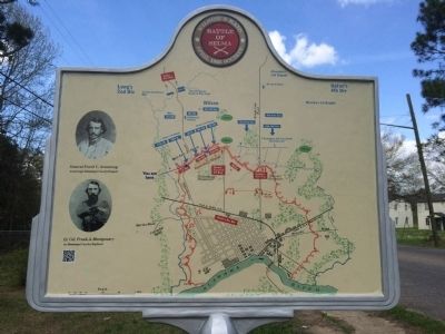
Redoubt No. 15 located just to the west of Summerfield Road was defended by Colonel Pinson's 1st Mississippi Cavalry Regiment of Anderson's Brigade. Their 400 men held positions on the west side of the road and the rest of Armstrong's present; . . . — — Map (db m81925) HM
Side 1
At prominent positions, earthen forts were built with artillery in position to cover the ground over which an assault would have to be made.
Redoubt No. 24 anchored the City's defenses at the junction of Valley Creek & the . . . — — Map (db m83581) HM
Confederate Army Captain James White was ordered to relocate the old Federal Arsenal from Mt. Vernon, Alabama. By 1865 it consisted of 24 buildings and had over 500 workers including men, women, boys, girls, FMofC and slaves. It made or contracted . . . — — Map (db m82750) HM
This boulder marks the site of the Selma Navy Yard and the Ordnance Works destroyed by the Federals 1865This tablet is placed in honor of the memory
of hundreds of faithful men who made these
great works a base for war material for the
entire . . . — — Map (db m37688) HM
Patton, a member of Shockley's Escort Company of the University of Alabama, was killed in a clash with the 4th Iowa Cavalry at the corner of Washington Street and Alabama Avenue. In November 1865 his father, Robert Miller Patton, was elected the . . . — — Map (db m83587) HM
following the Battle of Selma, April 2, 1865. This occupation protected the hotel from the arson and looting in the first 24 hours that destroyed much of downtown. In the next week Wilson methodically burned the huge military/industrial complex that . . . — — Map (db m80792) HM
Side A The original church, built one block south of the present site, was consecrated in 1843 by Bishop Leonidas Polk. In 1861, the second Bishop of Alabama, the Rt. Rev. Richard H. Wilmer, was elected there. During the Battle of Selma, St. . . . — — Map (db m37691) HM
The Lightening Brigade of the 2nd Division would spearhead the attack between Redoubts No. 13 - No. 16. Artillery covered all the approaches. At 5 p.m. General Long ordered the Second Division forward. "As Long's Second Division charged . . . — — Map (db m83682) HM
Cast Aug 24, 1863 in Selma at the
Confederate Naval Gun Foundry under
direction of Commander Catesby ap R. Jones.
Was the first gun shipped from the Selma
Foundry. Served as stern pivot gun on the
Selma-built ironclad ram CSS . . . — — Map (db m37678) HM
Selma’s Water Avenue is one of the finest surviving examples of a 19th century riverfront street in the south. Located here are structures which reflect the architectural trends in commercial buildings from 1830 to 1900.
This was the main . . . — — Map (db m37669) HM
This Italianate style cottage was built in 1859 by C. B. and Martha Todd White. Mrs. White, half sister of Mrs. Abraham Lincoln, was an outspoken Southern patriot, who subjected the Lincolns to severe criticism, when the Northern press accused her . . . — — Map (db m38274) HM
By 1865 General Nathan Bedford Forrest had been promoted Cavalry
Chief for the Department of Alabama, Mississippi, and Louisiana
under General Richard Taylor. On learning of Wilson's advance into
Alabama, Forrest had to determine Wilson's . . . — — Map (db m224549) HM
(front)
1861 1865
To the Confederate Soldiers.
Some of whom sacrificed all, and all of whom sacrificed much.
(left side)
On fame's eternal camping ground their silent tents are spread, and glory guards with solemn . . . — — Map (db m100368) WM
On Aug. 29, 1863, the Union XX Army Corps under Maj. Gen. Alexander M. McCook and the Army of the Cumberland's cavalry under Maj. Gen. David S. Stanley broke camp at Stevenson, AL and crossed the Tennessee River at Caperton's Ferry. This force of . . . — — Map (db m156168) HM
Robinson Springs Camp
1861-1865
Confederates
These lent our cause it's Holy Consecration
left front:
Volunteers from Robinson Springs Community,
Abercrombie, Leonard ∙ Allen, James M. Co. D. 21 Ala. Regt. ∙ . . . — — Map (db m83692) WM
Brigadier General Birkett Davenport Fry, CSA
(1822-1891)
In his lifetime General Birkett D. Fry was a cadet at Virginia Military Institute and West Point; 1st Lt. (U.S. Infantry) in Mexican War; lawyer in California; mercenary-soldier of . . . — — Map (db m95112) HM
Only Confederate armory not destroyed during the Civil War.
Col. Gorgas, ordnance chief, had carbine shop moved here into Tallassee Mfg. Co. mill in spring, 1864 as war threatened Richmond, Va. armory.
War ended before plant neared goal of . . . — — Map (db m83722) HM
Built, 1856, dedicated 1857, combining exterior Gothic style with Greek Revival interior. Original part designed as a rectangular block. Wings were added on eastern and western sides in the middle 1900's. At that time a choir rail replaced original . . . — — Map (db m67943) HM
In 1834, the Wetumpka Toll Bridge Co. built the first of four bridges spanning the Coosa River at this site. It was destroyed in a flood in 1844. A second toll bridge was completed the same year by John Godwin whose slave, Horace King, designed . . . — — Map (db m69449) HM
1940
One half mile from this site
is the home of
William Lowndes Yancey
1814-1863
American Statesman
Southern Secession Leader
Silver Tongued Orator — — Map (db m71550) HM
Settled by A.J. Hall in 1852 and occupied by Confederate troops because of its value as a railroad stop during the War Between the States (1861-65), Canoe was the site of a March 27, 1865 encampment of Union forces. The 1870s brought expansion . . . — — Map (db m72265) HM
A pre Civil War structure, this is the oldest church building remaining in Escambia County, Alabama. Confederate veterans related stories that mules and horses were sheltered inside during harsh winter months. Circuit riders served the church in the . . . — — Map (db m84388) HM
Located 1½ miles south, town of Pollard established 1861 at juncture of Alabama & Florida and Mobile & Great Northern railroads. Named for Charles T. Pollard, builder of Alabama & Florida Railroad.
One of largest military training camps of . . . — — Map (db m84371) HM
Here girl heroine led Forrest’s (CSA) men across Black Creek on way to capture Streight’s (USA) raiders.
This saved the railroad supplying Confederate Army of Tennessee. — — Map (db m39131) HM
Here on the morning of May 2, 1863 Emma Sansom braved the fire of Colonel Streight’s sharpshooters as she guided General Nathan Bedford Forrest and his gallant cavalrymen to the ford at this spot where they crossed Black Creek, at that time a raging . . . — — Map (db m39340) HM
In memory of the Gadsden Alabama girl heroine Emma Sansom, who when the bridge across Black Creek had been burned by the enemy, mounted behind Gen. Forest and showed him a ford where his command crossed. He pursued and captured that enemy and . . . — — Map (db m12297) HM
The surrounding area and this well was part of Turkey’s Town, once a capital of the proud Cherokee Nation. Chief Turkey was the principal chief during the late 1700’s.
On October 25, 1864, the Turkey Town Valley Expedition of the XV Corps Union . . . — — Map (db m83740) HM
On the night of May 2nd and the morning of May 3rd, 1863, John Wisdom rode 67 miles, from Gadsden, Ala. To Rome, Ga. Under very harassing conditions, to warn the citizens of Col. A. D. Streight’s proposed march to burn and sack the city, Rome being . . . — — Map (db m41001) HM
In an August 1848 election, citizens chose the center of Franklin County as the new county seat. Since no town existed in the center of the county, the state legislature incorporated the town of Frankfort, and it became the county seat in 1849. Five . . . — — Map (db m215976) HM
Beginning in Lauderdale County where it connected to Jackson's Old Military Road, Byler's Turnpike ran to Tuscaloosa. Only days after Alabama's statehood 14 Dec 1819, this first state road was approved by the legislature. Laid out along portions of . . . — — Map (db m153263) HM
By appointment of Tuscaloosa Presbytery, November 18, 1848 Rev. J. L. Kirkpatrick and Rev. C. A. Stillman organized a Presbyterian Church at Pleasant Ridge, Alabama.
There were thirteen charter members. Services were held in a home near site of . . . — — Map (db m92649) HM
Built in 1828-29 by John Gayle,
sixth governor of Alabama.
Birthplace of
Amelia Gayle Gorgas,
wife of Gen. Josiah Gorgas,
Chief of Ordnance, CSA,
mother of Wm. Crawford Gorgas,
US Surgeon General who freed
Canal Zone of yellow fever. . . . — — Map (db m83754) HM
This parish established 1830.
Third oldest in Alabama diocese.
Church consecrated in 1843 by
Leonidas Polk, Bishop of Louisiana,
(later a Confederate general).
Here Nicholas H. Cobbs was chosen
first Bishop of Alabama in 1844. . . . — — Map (db m33747) HM
(side 1)
Captain Dennis Harrison Zorn
Dennis Harrison Zorn was born in 1843 at Lodi, Barbour County, Alabama. At the outbreak of the Civil War, he entered the service in the 15th Alabama Infantry. He lost an arm at Cold Harbor in . . . — — Map (db m176019) HM
South side
To those who made
the supreme sacrifice
1917 - World War - 1918
—
Till the day breaks and
the shadows flee away
North side
Erected by Headland Chapter, U.D.C.
To the soldiers of the Confederacy . . . — — Map (db m71871) WM
To the glory of God
and in memory of
those boys who went from
Henry County, Alabama
to the battlefields of the
Confederacy
1861-1865 — — Map (db m71840) WM
Old Center Methodist Church
The church was organized in 1859. The first building was a log structure located just NW of the present building. In the 1870's it was part of the Newton Circuit and was served by a minister who lived in the . . . — — Map (db m71831) HM
Vital Memphis-Charleston Railroad, "backbone of Confederacy", spanned Tennessee River here. Bridge burned several times, 1862-3.
Gen. Mitchell (US), occupying Huntsville after Battle of Shiloh, seized Bridgeport in April 1862 and held it . . . — — Map (db m83788) HM
This stone placed here as a memorial
to the brave men and women who
fought to defend their homeland against
northern invaders during the
War for Southern Independence.
Poor dirt farmers and homemakers who
owned neither slave nor . . . — — Map (db m197502) WM
(Front): Before the courthouse was completed, the community selected a location for a cemetery. The highest elevation in Bellefonte's corporate limits was chosen as the town's burial place. The earliest inscribed marker in Bellefonte Cemetery . . . — — Map (db m83790) HM
(side 1)
The History of Paint Rock, Alabama
Originally Camden circa 1830, the post office was renamed Redman in 1846 and became Paint Rock on May 17, 1860. After the Memphis and Charleston Railroad Co. built a depot and water . . . — — Map (db m69756) HM
This location opens a window to the life of Scottsboro's founder and first city planner, Robert Thomas Scott, Sr. Here he and his wife Elizabeth built a pre-Civil War home, White Cottage, about 1850. Robert T Scott died June 1863 of heat exhaustion . . . — — Map (db m167008) HM
Robert T. Scott, born in 1800 into a prominent North Carolina family who originally settled in Maryland, founded the Alabama town that bears his name. Between 1848 and 1858, he acquired 1,240 acres of choice land in the heart of Jackson County. . . . — — Map (db m166957) HM
The Memphis and Charleston Railroad Company constructed the Scottsboro Railroad Depot in 1860-1861 as a passenger and freight facility. The rail line ran throughout the Confederacy and the Union considered its capture vital to cutting off supplies . . . — — Map (db m22258) HM
In late December 1863, Union Maj. Gen. John A. Logan established his Fifteenth Army Corps headquarters in Scottsboro, Alabama. On January 11, 1864, by command of Gen. Logan, Brig. Gen. Hugh Ewing, commanding the Fourth Division, was ordered to guard . . . — — Map (db m100044) HM
During the Reconstruction Period following the Civil War, a freedmen’s community was established in this area called Averyville, named for the Pennsylvania minister and successful businessman Charles Avery, a longtime and faithful champion of Negro . . . — — Map (db m108803) HM
Constructed by the Union Army in the summer of 1862 and expanded in 1864, using soldiers and freed slaves, Ft. Harker was built on a broad hill a quarter mile east of town. It overlooked Crow Creek and was well within firing range of Stevenson's . . . — — Map (db m83795) HM
A one-story depot building was constructed here in 1853, when the railroad was first laid through Stevenson. That building burned after the Civil War and was replaced by the present brick depot and hotel in 1872.
During the Civil War, Stevenson . . . — — Map (db m22271) HM
Stevenson was a major supply station and staging ground for decisive campaigns and battles of the Civil War. This small house, called "The Little Brick," was alive with activity when General William S. Rosecrans relocated his command here on . . . — — Map (db m87983) HM
Alabama’s Winter Waterfowl
The Tennessee River Valley is the winter home for thousands of waterfowl. These birds migrate from across the northern US and Canada down through the center of the continent to the Tennessee River.
Careful . . . — — Map (db m106298) HM
Thomas Hennington Owen,
grandson of Methodist
minister, David Owen and
Lucy McCraw, moved into
the 2 room rear wing with his
bride Malissa Rose Sadler in
1833. Second wife was Mary
Elizabeth Tarrant. The 2 story
addition in 1838 was . . . — — Map (db m215730) HM
Dr. Mortimer Harvie Jordan and his wife, Florence E. Mudd, constructed their home between 1906 and 1908. After service in the Confederate army, Jordan studied medicine in Cincinnati and New York (under Alabama's famous gynecologist, Dr. J. Marion . . . — — Map (db m26743) HM
First blast furnace in Jefferson County erected near this site (1863) by Red Mountain Coal and Iron Co. Destroyed (1865) by Federal troops: rebuilt (1873) and second furnace added. Successful experimental run made in Furnace No. 2 (1876) using . . . — — Map (db m27280) HM
(front): United Confederate Veterans Camp Hardee No. 39 Camp Hardee No. 39 was organized as a camp of the United Confederate Veterans on August 7, 1891. This cemetery plot was acquired by the camp to provide a final resting place for the men . . . — — Map (db m12487) HM
Gen. James H. Wilson, USA, having crossed the Tennessee River with a large force of well equipped cavalry, grouped them here at Elyton.
Their mission: to destroy Alabama's economic facilities for supporting the War.
From these headquarters he . . . — — Map (db m24358) HM
From 1820 until 1878 this bell hung in the
belfry of the old Elyton courthouse, one-half mile northeast of this spot. In 1861
Jefferson County boys were mustered in
there and the bell tolled them off to war.
John Felix McLaughlin was one of . . . — — Map (db m216063) HM
Established about 1850, Wear Cemetery is located off Old Springville Road to the northeast at Countryside Circle. In the 1800's the Wear family was among the first settlers of the community later known as Clay. Twenty-three remaining graves were . . . — — Map (db m25113) HM
Union Hill Cemetery is the burial ground of many pioneers and early settlers of the Shades Valley area. It was established in the 1870s, but includes gravestones dating back to the early 1850s due to the relocation of two earlier, smaller cemeteries . . . — — Map (db m83873) HM
Jonathan Bass was born January 30, 1837, in Jefferson County. His father arrived in Jefferson County in 1816, and Jonathan was a life-long resident. Although the Bass House was under construction as early as 1863, Jonathan left the farm to join the . . . — — Map (db m24697) HM
This historic roadway, originally connecting to Eastern Valley Road, was a much-traveled access route to the John Wesley Hall Gristmill beginning in 1867.
During the Civil War, this route was used by the 8th Iowa Cavalry to attack the Tannehill . . . — — Map (db m215727) HM
The John Wesley Hall Grist Mill & Cotton Gin operated on this site from 1867 to 1931, was successor to one of Alabama's earliest grist mills located a mile west on Mud Creek.
Burned during the Civil War, Hall's Mill was moved to this location . . . — — Map (db m107515) HM
In 1821 the first settlers came to this area, later called Waddell. Large numbers of people first migrated here in 1863 with the construction of the Irondale Furnace. Destroyed in the Civil War, the furnace was rebuilt and operated from 1867 to . . . — — Map (db m26769) HM
Wallace S. McElwain (1832-1888)McElwain trained in a gun factory in New York and in a foundry in Ohio before moving to Holly Springs, MS, where he operated Jones, McElwain and Company Iron Foundry. He was well known in the Southeast for his . . . — — Map (db m26266) HM
In honor of the men from Mt. Pinson who formed the "Jefferson Warriors" in mid-July, 1861. Marching to Huntsville, they were mustered into the Confederate army on August 12th as Company C of the Nineteenth Alabama Infantry Regiment under the . . . — — Map (db m26988) HM
Pinson, one of Alabama’s oldest communities, was settled by General Andrew Jackson’s soldiers in the early 1800s, after victory at Horseshoe Bend during the War of 1812. The community was originally known as Hagood’s Crossroads for settler . . . — — Map (db m88406) HM
On this site stood the stone warehouse of Captain Thomas Truss and Marcus Worthington. Stored here were meats, grains and clothing collected by the Confederate government as a war tax. Disabled C.S.A. veteran Felix M. Wood was receiver of the tax at . . . — — Map (db m25819) HM
This cemetery is named for the nearby Montneba Presbyterian Church, or Mt. Nebo, which was originally established on October 2, 1867, as the Presbytery of Springville Synod. On October 25, 1958, this church was renamed First Presbyterian Church of . . . — — Map (db m217759) HM
Farmer Confederate Soldier Legislator
Member U.S. House and Senate
Thirty Three Years
Father of Federal Aid to Good Roads
Author making Warrior
longest canalized river in the world
Active in
development of Muscle Shoals and other . . . — — Map (db m96473) HM
(side 1)
Early settlers in Anderson date back to 1818 when James Anderson settled approximately a mile south of here. The earliest permanent settlement was located about one mile north of here on Anderson Creek around 1825 and was known . . . — — Map (db m133189) HM
(side 1)
Center Star was spelled Centre Star into the 1900s. The name evolved from the US Postal Service, which served remote areas by "star routes." The Post Office here, which existed from 1850 to 1914 (except between 1902 and 1913), . . . — — Map (db m82398) HM
(side 1)
Settlement of this area began in the early 1800s. Gabriel Butler settled approximately two miles northwest of here on Bluewater Creek. His name is found on the 1810 petition for removal of white settlers leasing land on Chief . . . — — Map (db m83934) HM
About one mile west of here is the site of the Globe Cotton Factory which was erected on Cypress Creek in 1840. By 1857 its operations included three cotton mills, a flour mill, and two corn mills, all powered by the use of three dams. By 1860 the . . . — — Map (db m83938) HM
This "double- pile cottage" is a rare Alabama example of Tidewater architecture that originated along the Southern seaboard during the colonial period. This house was built in 1833 by Thomas J. Crowe, proprietor of the early National Hotel in . . . — — Map (db m83962) HM
George Washington Foster, planter, built this Greek Revival Mansion. An Act of the legislature was required to close Court Street, In fall of 1864 it was headquarters of Nathan B. Forrest, General, CSA. Foster's daughter, Sarah Independence McDonald . . . — — Map (db m28868) HM
Built in 1840's, acquired 1857 by Edward Asbury O'Neal. Occupied various times during Civil War by Federals and Confederates. Edward A. O'Neal (1818-1890) attended LaGrange College; lawyer, Colonel of the 26th Alabama Regiment, C. S. A.; appointed . . . — — Map (db m153224) HM
When the city was surveyed this land described as "outside the city limits" was designated as the burying grounds for the new town. It contains the graves of early settlers, including a son and brother of Ferdinand Sannoner, Surveyor of Florence, . . . — — Map (db m83968) HM
Following his tragic defeat at Franklin and Nashville, General John B. Hood managed to escape over the Tennessee River at Bainbridge Ferry, a few miles south of here on December 26, 1864. Two corps under General Benjamin Cheatham and Stephen D. Lee . . . — — Map (db m35258) HM
Side 1:
To the south of this marker is the Hickory Hill Plantation Slave Cemetery which contains the remains of approximately 140 African-Americans. These individuals labored in the bonds of slavery during the period 1818 to 1865 and many . . . — — Map (db m138778) HM
Built by Andrew Jackson, 1816~1820. Shortened by 200 miles the route from Nashville to New Orleans for movement of supply wagons and artillery.
Built with U.S. funds and troops.
Followed in part Doublehead's Road from Columbia, Tenn., to Muscle . . . — — Map (db m65290) HM
This bottom land serves as a reservoir for TVA's flood control program.
Florence leases it for recreational purposes when not being used by TVA.
Major Robert McFarland, a native of Ireland, his wife, Kate Armstead McFarland, and their seven . . . — — Map (db m28453) HM
This expansion includes all the houses on East Hawthorne and Meridian Streets and many on Kendrick Street with ages ranging from an 1832 townhouse to bungalows built in the 1920s. In July 1862 the Union forces under General Don Carlos Buell camped . . . — — Map (db m156980) HM
This high elevation was used by both armies during the Civil War. Large earthworks were
constructed in February 1862 by Confederate Brigadier General Daniel Ruggles. At the time, more than 500 sick and wounded soldiers were being treated in . . . — — Map (db m156920) HM
Constructed by 1830 by Leroy Pope as a Stagecoach Stop, Tavern and Inn and named Pope's Tavern.
The building was used as a Hospital by both Union and Confederate Soldiers during the War between the States.
In 1874 it as purchased for a . . . — — Map (db m212435) HM
Built by John Simpson in 1843, on the site of his earlier home, this residence was occupied at various times by both armies during the Civil War. Purchased in 1867 by George W. Foster, builder of Courtview, for his daughter, Virginia, and her . . . — — Map (db m45808) HM
This area is the military cemetery for Confederate Soldiers. After an 1862 skirmish in the streets of Florence, it was used to bury casualties until the end of the Civil War. Many unknown Confederates and a few unknown Union soldiers rest here. . . . — — Map (db m28402) HM
Home of Major John Brahan, veteran War of 1812.
Major General, Alabama Militia, who owned 4,000 acres here. Built of bricks made on the place, marble mantels imported from Italy, boxwood hedge from London. Named for spring nearby.
Federal and . . . — — Map (db m28404) HM
Chartered 1856 as Florence Wesleyan University, R.H. Rivers, President. Regarded as North Alabama's most eminent landmark, this Gothic Revival Structure was designed by Adolphus Heiman, Nashville, And built by Zebulon Pike Morrison, Florence, as new . . . — — Map (db m28864) HM
Prior to the repeal of the Militia Act in 1902, states maintained their own militia. One of the last militia in Florence and Lauderdale County was the Wheeler Rifles.
Organized in 1888, under the command of Captain Julian Fields, it was named for . . . — — Map (db m32774) HM
Side A
In 1818 three Wilson brothers John, Matthew and Samuel, came from Virginia to purchase large farms in this area. The plantations of John and Matthew joined near this cemetery. All three brothers and their families are buried here. . . . — — Map (db m28160) HM
Two hundred feet from where you are, in 40 feet of water, are the remains of Lock Six, the headquarters for a locking system of 9 locks that provided river traffic around the rapids and shoals. The river fall of 136 feet in about 37 miles prevented . . . — — Map (db m141979) HM
(side 1)
Approximately 1.5 miles north of here, across Bluewater Creek near CR76, is the location of an early settlement known as Mitchell Town named for the Mitchells who settled there. In 1833, Samuel Herston owned land in the area which . . . — — Map (db m90837) HM
(side 1)
At this location is the Elk River that flows into the Tennessee River approximately four miles south of here. That location is the easternmost point of a massive underwater formation which was exposed until the early 1900s. The . . . — — Map (db m133187) HM
(plaque)
"Trusted, honored, and loved by the people of Alabama for his splendid character and distinguished service as a citizen and soldier." Born September 10, 1836, in Augusta, Georgia, Joseph Wheeler graduated from West Point in 1859, . . . — — Map (db m84295) HM WM
(Side 1)
From about 1775 until his death on August 9, 1807, Chickamauga Cherokee Chief Doublehead controlled the Muscle Shoals of the Tennessee River. Two major Indian trails, Sipsie Trail and an east-west trail, intersected in the . . . — — Map (db m99972) HM
(side 1)
Springfield Community 1810
Springfield Community is believed to have been among the earliest settlements in Lauderdale County. It was laid out as a town and considered as the location for the county seat. As early as 1810, . . . — — Map (db m100604) HM
585 entries matched your criteria. Entries 201 through 300 are listed above. ⊲ Previous 100 — Next 100 ⊳