On North Center Street (State Highway 31) north of 2nd Street, on the right when traveling north.
The 3-inch Ordnance Rifle was also known as the ordnance rifle, the ordnance gun, the Griffen gun, and was sometimes erroneously referred to as the Rodman rifle. The gun was invented by John Griffen, superintendent of the Safe Harbor Iron Works in . . . — — Map (db m65711) HM
On Arkansas Route 31 at Flynt Lane, on the right when traveling north on State Route 31.
On August 25, 1863 U.S. and Confederate Cavalry clashed near here. The initial battle involving approximately 7,000 men occurred east of the town. After a brief artillery duel, Col. Geiger's US troopers forced the retreat of Gen. Marmaduke's CS . . . — — Map (db m116458) HM
On SE Front Street (U.S. 70) 1 mile east of Honeysuckle Lane, on the left when traveling east.
Hicks' Station, located on the Memphis & Little Rock Railroad between DeValls Bluff and Huntersville (N Little Rock), guarded the eastern approaches to the capital city. During the Little Rock Campaign, Confederate cavalry used it as a staging area . . . — — Map (db m72142) HM WM
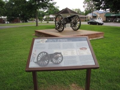
On North Center Street (State Highway 31) north of 2nd Street, on the right when traveling north.
West SideBelow an image of two crossed flags and the dates 1861-1865 In memory of our Confederate Soldiers North Side Erected by the T.C. Hindman Chapter U.D.C. Lonoke, Ark. East Side Lonoke County commends the . . . — — Map (db m65714) WM
On Arkansas Route 31 at Flynt Lane, on the right when traveling north on State Route 31.
On the morning of August 25, 1863, at Bayou Two Prairie (east of where you are standing), Confederate Brigadier General John Marmaduke's troops skirmished with advance elements of Union forces under Brigadier General John Davidson. Marmaduke's . . . — — Map (db m116392) HM
On West War Eagle Avenue at West Main Street (Business U.S. 412), on the right when traveling west on West War Eagle Avenue.
Front
On January 10, 1863, nine men, including two Confederate officers and prominent local citizens and Masonic lodge members, were taken from a guardhouse near here, led to Samuel Vaughn's farm one mile northeast of Huntsville, and shot. . . . — — Map (db m141514) HM
On West War Eagle Avenue at West Main Street (U.S. 412), on the right when traveling west on West War Eagle Avenue.
Front
Isaac Murphy was born Oct. 16, 1799, in Pennsylvania. A teacher and lawyer, he moved to Fayetteville in 1834 and became involved in politics. Murphy took part in the 1849 Gold Rush, but lost his farm to creditors. He, his wife and . . . — — Map (db m141518) HM
Near Potter Lane at State Route 14, on the left when traveling east.
Yellville In The Civil War
While there were no major battles fought in Marion County, the area saw many scouts, expeditions and skirmishes during the Civil War, and civilians endured both soldiers and guerrillas. In November 1862. Union . . . — — Map (db m160309) HM
Near McClure Road at Cobb Lane, on the left when traveling east.
When Gen. Frederick Steele's Union army invaded southwest Arkansas in April 1864, threatening the Confederate state capital at Washington, Gov. Harris Flanagin moved the state archives to Rondo, where they were deposited in James Abraham's store. . . . — — Map (db m96022) HM
An expedition of about 100 soldiers of the Second Missouri Artillery (U.S.) set out from Osceola on April 5, 1864, in pursuit of guerrillas who had just robbed the town. Marching through dense swamps with water from 1 to 3 feet deep, the Missouri . . . — — Map (db m170408) HM
On May 10, 1862, Confederates defeated the Union navy in one of only two Civil War gunboat fleet engagements on the Mississippi River, ramming and sinking two Union ironclads, Cincinnati and Mound City. A reinforced Union armada routed the . . . — — Map (db m36320) HM
On North Walnut Street (U.S. 61) at West Hale Avenue, on the right when traveling north on North Walnut Street.
1861 - 1865 In memory of the Confederate Veterans of Mississippi County erected A.D. 1934 United Daughters of the Confederacy Elliott Fletcher Chapter Bytheville Arkansas — — Map (db m36531) HM
On Arkansas Route 198 east of County Road 661, on the left when traveling east.
In late July 1864, Missouri Union cavalry headed south into Mississippi County to hunt for bands of guerillas. On August 2, they encountered Confederate pickets near Osceola and pursued them to the main force led by Captains Charles Bowen and H.M. . . . — — Map (db m170412) HM
Upon the Civil War's outbreak, Capt. Charles Bowen raised a company known as the "Osceola Hornets," participating in the battles of Belmont and Shiloh. Initially 100 strong, only seven returned. During Reconstruction, Bowen was instrumental in . . . — — Map (db m36328) HM
On State Highway 198, on the left when traveling west.
The 10,000-acre Sans Souci plantation established in 1854 by John Harding McGavock, served as a Civil War hospital as the Union fleet docked across from the home. In addition to farming cotton, much acreage was devoted to hunting deer, bear, and . . . — — Map (db m36298) HM
On U.S. 79, 0.3 miles west of State Highway 86, on the right when traveling west.
Known as "Mouth of Cache" 1799-1837, Clarendon by 1828 had a post office and ferry and was the crossing for the Memphis to Little Rock Military Road. The town became Monroe County seat in 1857 and was incorporated two years later. Destroyed by Union . . . — — Map (db m155262) HM
On Madison Street at North 2nd Street, on the right when traveling west on Madison Street.
Clarendon was a major White River port and crossroads when the Civil War began. Six Confederate companies were raised here and in Monroe County in 1861-2. A Union fleet tried to supply the Army of the Southwest here in June 1862, but turned back . . . — — Map (db m152977) HM
On George Street east of West Street, on the left when traveling east.
In memory of
the 382 men of Montgomery Co. Arkansas
who served in the Confederate States Army
1861 — 1865
4th AR. Inf. Co. C.
4th AR. Inf. Co. F.
33rd AR. Inf. Co. I.
Lest We Forget — — Map (db m226211) WM
On George Street west of East Street, on the right when traveling west.
Montgomery County men served in several Confederate units during the Civil War. The “Montgomery Hunters” (Co. F) and “Caddo Rifles” (Co. C) joined the 4th Arkansas Infantry in 1861. Co. I, 33rd Arkansas Infantry was raised at Caddo Gap in 1862, and . . . — — Map (db m200630) HM
On Nevada 23 Road (County Road 23) near County Road 423, on the left when traveling north.
You are standing where, after four days of
skirmishing on Prairie D' Ane northeast of here,
Union troops of John Thayer's Frontier Division
guarded the rear of Frederick Steele's army as it
advanced toward Camden in search of supplies.
On April . . . — — Map (db m202467) HM
On Nevada 23 Road (Arkansas Route 23) north of County Road 423, on the left when traveling north.
Action at Moscow
After skirmishing for several days at Prairie D’Ane, Gen. Frederick Steele turned his starving Union army away from Louisiana and headed toward Camden to seek supplies. Confederate cavalry under T.P. Dockery and S.B. Maxey . . . — — Map (db m200730) HM
On Blevins Road (U.S. 371) west of Interstate 30, on the right when traveling west.
Gen. Sterling Price’s Confederate army held strong earthworks on the western edge of Prairie D’Ane when Gen. Frederick Steele’s Union troops approached on April 10, 1864, and dug their own trenches. After heavy fighting on the 10th, the combatants . . . — — Map (db m96559) HM
On Court Street (State Highway 7) at Stone Street (State Highway 7), on the right when traveling east on Court Street.
Civil War in Newton County Several military actions took place in Newton
County during the Civil War. On Jan. 10, 1863, Union
troops attacked and destroyed a large saltpeter
works on the Buffalo River. Skirmishes were fought
June 14 and Nov. . . . — — Map (db m225345) HM
On Arkansas Route 24, 0.8 miles south of Ouachita Road 62, on the right when traveling south.
The 1st Kansas Colored Infantry, a regiment that included many former Arkansas slaves, was formed in August 1862, the first black unit recruited during the war. 1st Kansas troops were the first black men to see combat, losing 10 killed and 12 . . . — — Map (db m56624) HM
In the fall of 1864, much of the Confederate infantry in Arkansas was ordered to move to Camden to protect the approaches to Texas during General Sterling Price’s absences in being transferred to the Missouri Campaign.
In September 1864, . . . — — Map (db m106889) HM WM
On Bradley Ferry Road at Progress Street, on the left when traveling west on Bradley Ferry Road.
This is one of nine Civil War fortifications that were
constructed in 1863-64 by Confederate soldiers and
slaves under the command of Camden lawyer, Colonel
Alexander Hawthorn.
Located atop a steep hill well over a mile southeast of
Redoubt . . . — — Map (db m200821) HM
On Rogers Street NW at Monroe Avenue, on the right when traveling west on Rogers Street NW.
This is one of nine Civil War fortifications that were
constructed in 1863-64 by Confederate soldiers and slaves
under the command of Camden lawyer, Colonel Alexander
Hawthorn.
This massive earthen redoubt contained a battery of . . . — — Map (db m200797) HM
On Cleveland Avenue NW at McColough Street NW, on the left when traveling north on Cleveland Avenue NW.
This is one of nine Civil War fortifications that were
constructed in 1863-64 by Confederate soldiers and
slaves under the command of Camden lawyer, Colonel
Alexander Hawthorn.
This square earthworks faced west and held as many as
six . . . — — Map (db m200805) HM
On California Avenue NW at Center Street NW, on the left when traveling north on California Avenue NW.
This is one of nine Civil War fortifications that were
constructed in 1863-64 by Confederate soldiers and
slaves under the command of Camden lawyer, Colonel
Alexander Hawthorn.
Located at the highest elevation between Willow, . . . — — Map (db m200813) HM
On Maul Road at Greenwood Avenue NW, on the left when traveling west on Maul Road.
This is one of nine Civil War fortifications that were
constructed in 1863-64 by Confederate soldiers and
slaves under the command of Camden lawyer, Colonel
Alexander Hawthorn.
Located along a ridge some one hundred yards south of
the . . . — — Map (db m200802) HM
To the Confederate women
Whose pious ministration
To our wounded soldiers,
Soothed the last hours of those
Who died far from the objects
Of their tenderest love;
Whose domestic labors
Contributed much to supply
The wants of . . . — — Map (db m106934) HM WM
On Arkansas Route 76, 0.2 miles east of County Road 175, on the left when traveling east.
At about 9:30 a.m. Federal
patrols made contact with
Confederate scouts near Poison Spring. Colonel Williams
parked his wagons two and
three abreast, as close together
as possible. He ordered the
First Kansas to the front forming a line, and . . . — — Map (db m201023) HM
On Arkansas Route 76, 1.2 miles west of County Road 100, on the right when traveling west.
Here on April 18, 1864 a Union forage train of 200 wagons escorted by 1170 men was attacked and captured by Confederate troops commanded by Generals John S. Marmaduke and Samuel B. Maxey. The wagons were loaded with corn for the Union army of . . . — — Map (db m242745) HM
Near Arkansas Route 76, 1.2 miles west of County Road 100, on the right when traveling west.
Critical Shortage of Food and Forage...
More than three weeks of marching
and fighting depleted Steele's sup-
plies. His troops had been on half
rations for more than two weeks and
unauthorized foraging was widespread.
The capture of . . . — — Map (db m201020) HM
On Arkansas Route 76, 1.2 miles west of County Road 100, on the right when traveling west.
Williams, despite being outnumbered, defended the train as long as possible,
hoping for reinforcements from Camden. After a short and hotly contested
engagement at close range, the black troops broke ranks, retreating in chaos.
The Confederates . . . — — Map (db m201024) HM
Near Arkansas Route 76, 1.2 miles west of County Road 100, on the right when traveling west.
Confederate Units
Task Force - Brigadier General Samuel B. Maxey
Brigadier General William L. Cabell
1st Arkansas Cavalry Col. J.C. Monroe
2nd Arkansas Cavalry Col. T. J. Morgan
4th Arkansas Cavalry Col. A. Gordon
7th Arkansas . . . — — Map (db m201026) HM
On Arkansas Route 76, 0.2 miles east of County Road 175, on the right when traveling east.
The Poison Springs Battle Ground, less than three miles westward, was the scene of an important action contributing to the retreat of the Federal Army under General Steele from Camden and south Arkansas to Little Rock. A surprise attack by the . . . — — Map (db m242743) HM
Near Arkansas Route 76, 1.2 miles west of County Road 100, on the right when traveling west.
The Federal government's unsuccessful Red River Expedition in April, 1864 was the last major invasion of Confederate territory west of the Mississippi River. Its aim was to capture Shreveport, Louisiana, open Texas to Federal occupation and acquire . . . — — Map (db m201019) HM
On Arkansas Route 76, 1.2 miles west of County Road 100, on the right when traveling west.
Due to their reputation for fierce fighting, Colonel Williams positioned
the First Kansas Colored Infantry to guard the Union train against the
heaviest Confederate onslaught. They successfully repulsed two enemy
attacks, but with heavy losses. . . . — — Map (db m201025) HM
On West Main Street at North Plum Street, on the left when traveling east on West Main Street.
Perry County men served on both sides in the Civil War. Many enlisted in Company B, 1st Arkansas Mounted Volunteers, the Perry County Rangers, in 1861. Later designated the 3rd Arkansas Cavalry, the troops fought for the Confederacy east of the . . . — — Map (db m156837) HM
On Arkansas Route 85, 1.2 miles south of Old Little Rock Road, on the right when traveling north.
After the Jan. 11, 1863, battle at Arkansas Post, Gen. Willis Gorman led troops from Helena on a raid up the White River. Col. Powell Clayton and 1,200 cavalrymen went to Big Creek west of Helena when a patrol of 25 men of the 2nd Wisconsin Cavalry . . . — — Map (db m107709) HM
The nickname the 33rd Iowa Infantry gave Helena was hardly flattering. It came not from a hard fought battle but from miserable conditions in an overcrowded city made worse by the climate.
Soldiers Battled Malaria, Typhoid and More
Many . . . — — Map (db m51916) HM
Near Cherry Street south of Rightor Street, on the right when traveling south.
"A Liberating Army"
In September 1861, Frederick Douglass, a former slave and
passionate and influential advocate for black rights, wrote,
"Let it be known that the American flag is the flag of freedom
to all who will . . . — — Map (db m108009) HM
David D. Porter, Acting Rear Admiral Commanding Mississippi Squadron
The guns of the U.S.S. Tyler sent their last blast hurtling toward Graveyard Hill at 10:30 A.M. on July 4, 1863. The Confederates were retreating. . . . — — Map (db m229625) HM
Conditions in Civil War Helena were horrible. Overcrowding, poor sanitation, contaminated drinking water, and mosquitoes led to typhoid, dysentery, malaria and other diseases. Tents, churches, barns, abandoned houses and business buildings housed . . . — — Map (db m51978) HM
On Walnut Street at Perry Street, on the right when traveling north on Walnut Street.
The Civil War changed the lives of Southern women in ways they could not have imagined. They lived with anxiety, fear and loneliness. As the war ground on, many felt an increasing sense of desperation and depression. The lives they had known were . . . — — Map (db m107998) HM
The Death of General Patrick Cleburne
“If we are to die Govan, let us die like men,” Cleburne said to his friend, Daniel Govan, as he rode to his death.
Major General Patrick Ronayne Cleburne, Helena’s best-known Confederate . . . — — Map (db m107829) HM WM
Near Yorkshire Drive, 0.1 miles east of Audubon Drive when traveling east.
Battery C sat directly above Helena and was the key to the city's defenses. The small earthen battery manned by the 33rd Missouri held two artillery pieces. A series of infantry trenches in front of the battery defended the approach. Union engineers . . . — — Map (db m107956) HM
Near Yorkshire Drive east of Audubon Drive when traveling east.
Imagine this area covered in trees. Where you stand is a quiet
cemetery. It is the first burial ground for the city of Helena and
the resting place of some of the city's earliest residents.
Engineers and Battle Begin the . . . — — Map (db m107977) HM
The Confederate Memorial
In 1889, the Phillip County Memorial Association began raising funds to erect a grand memorial to honor all the Confederate dead.
The Association sent an appeal throughout the South and donations poured in. Not . . . — — Map (db m107834) HM
On Missouri Street east of Natchez Street, on the left when traveling east.
Thousands of refugee slaves came with the Union army into Helena and they continued to come. Helena became an island of freedom in a slave state.
The Union Army Recruits Freedmen
In the . . . — — Map (db m107912) HM
Near Yorkshire Drive, 0.1 miles east of Audubon Drive when traveling east.
The Confederates Take Battery C
"Both brigades moved forward on the instant, rapidly, steadily
unflinchingly, and in perfect order under a storm of Minie balls,
grape, and canister, which poured upon them not only . . . — — Map (db m107958) HM
Near Yorkshire Drive, 0.1 miles east of Audubon Drive when traveling east.
You are facing Battery D. One half-mile southeast of here, it was the closest of the fortifications on Crowley's Ridge to Battery C. During the Battle of Helena, Union troops at these batteries aided each other with artillery fire.
— — Map (db m107950) HM
On Missouri Street east of Natchez Street, on the left when traveling east.
The Union Army Takes Helena, July 1862
When General Samuel Curtis marched into Helena he was
not sure if he would remain. But the city's location on the
Mississippi River made it a valuable strategic resource . . . — — Map (db m107916) HM
On Biscoe Street (Business U.S. 49) at Little Rock Road on Biscoe Street.
The 2nd Arkansas of African Descent manned the earthwork located here during the Battle of Helena on July 4, 1863. The 2nd was a new regiment, organized in Helena just three months earlier. They had never experienced combat. . . . — — Map (db m107891) HM
On Walnut Street at Perry Street, on the right when traveling north on Walnut Street.
Disease, death, the practice of separating slave families—all left
children with no one to care for them. Scores of orphaned black
children in Civil War Helena suffered from neglect and exposure.
General Napoleon Buford asked for help. In . . . — — Map (db m107999) HM
On Adams Street east of Beech Street, on the right when traveling west.
Union forces entrenched on this hill held off repeated assaults by Confederate troops under CSA General Marmaduke on the morning of July 4, 1863, in their attack on Helena. CSA General Marsh Walker's Cavalry Brigade, consisting of the 5th Arkansas . . . — — Map (db m107784) HM
On Walker Street east of South Summit, on the left when traveling east.
Union guns emplaced on this hill defended Old St. Francis Road, the approach used by CSA General Marmaduke's Division, consisting of the 1st Brigade under Col. Shelby and Col. G.W. Thompson and the 2nd Brigade under Col. Colton Greene, in their . . . — — Map (db m107787) HM
Near Yorkshire Drive, 0.1 miles east of Audubon Drive.
Four maps drawn during the Civil War show Battery C. On each, the size and
shape of the battery is different. Archaeological investigations conducted in
2011 and 2013 uncovered some surprising facts about this battery.
— — Map (db m107964) HM
On Military Road, 0.1 miles west of Prairie Street, on the left when traveling south.
Hindman Hill, southernmost of four positions fortified by Union Forces in June, 1863, was attacked by the 35th, 37th, and Hawthorn's Arkansas Infantry Regiments under General Fagan, CSA at daybreak, July 4, 1863. Thwarted by the strength of the . . . — — Map (db m107791) HM
Near Yorkshire Drive, 0.1 miles east of Audubon Drive (Business U.S. 49) when traveling east.
Confederate General Theophilus Holmes wanted to regain control of Helena, an island of Union control in Confederate Arkansas. His attack failed. Miscommunication, lack of information, and the determined resistance of the Union troops, who vowed not . . . — — Map (db m107941) HM
Near Biscoe Street (Business U.S. 49) at Little Rock Road.
As soon as the Civil War began, black men volunteered to serve in the United States Army. They were denied. In the spring of 1863, the Federal government finally began enlisting Freedmen. Within months, thousands in Helena had . . . — — Map (db m107884) HM
In the first months of 1861 many Phillips County men joined militia companies supporting the Confederate cause. In February 1861, they marched on Little Rock to take the Federal arsenal. Most joined the Confederate army that spring.
A Divided . . . — — Map (db m51979) HM
Near Yorkshire Drive, 0.1 miles east of Audubon Drive when traveling east.
You are facing Battery A, which stood on Rightor Hill, a high spot on Crowley's Ridge. Defended by the 29th and 36th Iowa and the 33rd Missouri, it anchored the north end of the Union line, approximately one and one-quarter mile northeast of here. . . . — — Map (db m107973) HM
On York Street east of Beech Street, on the right when traveling east.
Shortly after the capture of Helena in July 1862, the Union army took
measures to protect the city. Engineers designed a large earthen fort,
which African American laborers completed in October 1862. General
Benjamin Prentiss named the heavily . . . — — Map (db m108033) HM
On Monroe Street at Cherry Street, on the left when traveling east on Monroe Street.
During the Battle of Helena on July 4, 1863, constant fire from Union cavalry and artillery near the levee helped stall the Confederate advance on Battery A.
The Union Troops at the Levee . . . — — Map (db m107930) HM
Near Cherry Street south of Rightor Street, on the right when traveling south.
Freedmen Fill Two Regiments
Within days of Lorenzo Thomas' speech in
Helena on April 6, 1863, enough Freedmen
enlisted to fill a regiment—1,000 men. Many
were already in Helena. Others came in . . . — — Map (db m108014) HM
When the Union army built Fort Curtis in 1862, the 34-star flag flew over the fort.
The day the Battle of Helena was fought, July 4, 1863, the 35-star flag became the official U.S. flag. The new star represented West Virginia, admitted to the . . . — — Map (db m109134) HM
On Perry Street at Columbia Street, on the right when traveling east on Perry Street.
In August 1862 the Union forces occupying Helena erected on this site a redoubt of earth and timbers to serve as the key to the city’s defenses. Fort Curtis, named for the Union general in command at the time of construction, was one of five . . . — — Map (db m51919) HM
On York Street east of Beech Street, on the right when traveling east.
The Confederates tested Fort Curtis once, during the Battle
of Helena on July 4, 1863.The battle ended in a decided
Union victory. For the rest of the war, Fort Curtis stood over
Helena, a symbol of the power of the Union army.
— — Map (db m108036) HM
The Emancipation Proclamation
"...all persons held as slaves within any State or designated
part of a State, the people whereof shall then be in rebellion
against the United States, shall be then, thenceforward, . . . — — Map (db m107885) HM
On Military Road, 0.1 miles west of Prairie Road, on the left when traveling south.
Hawthorn's Regiment advanced from the south, that of Bell from the north, King massed on Hawthorn's right. They charged at daybreak, clambering over fallen timber, and took the first line of rifle pits. Battery C not yet engaged by Price, caught . . . — — Map (db m107796) HM
Near Pecan Street south of Perry Street, on the right when traveling south.
"I am with the South in life or death, in victory or defeat."
Patrick Cleburne, May 1861
A Brilliant and Beloved Commander
Patrick Cleburne was a brilliant military tactician and one of
the . . . — — Map (db m109146) HM
On Martin Luther King Jr Drive (Business U.S. 49) at Business U.S. 49, on the right when traveling west on Martin Luther King Jr Drive.
At this site on the southern tip of Crowley’s Ridge, Indians of the Hopewell Culture lived about 500 B.C. Evidences of their settlements still remain in mounds nearby. In 1541 when Hernando De Soto crossed the river near here, he found the Casqui . . . — — Map (db m51910) HM
Near Biscoe Street (Business U.S. 49) at Little Rock Road.
Thousands of freedom seekers came with the Union army when it occupied Helena in July 1862. They had no place to live, no food and no way to support themselves.
Under the Army's Care
It was up to . . . — — Map (db m107877) HM
Near Biscoe Street (Business U.S. 49) at Little Rock Road.
Fortifying Helena
Soon after the Union army occupied Helena in July 1862, preparations
began for a Confederate attack. The army built four earthworks on
Crowley's Ridge. Fort Curtis sat below the ridge, in town. . . . — — Map (db m107887) HM
On Beech Street at York Street, on the right when traveling north on Beech Street.
After the Union army arrived in July 1862, Helena was no longer part of the Confederacy. It was in Union hands and the Union commander made law and policy. The Moore-Hornor Home across the street was one of many in Helena seized by the Union army. . . . — — Map (db m108030) HM
On Perry Street west of Cherry Street, on the right when traveling east.
While the vast majority of Helena's white population favored secession, there were also men and women loyal to the Union in Phillips County.
White Unionists Rally in Helena
Not only fugitive slaves, but white . . . — — Map (db m107991) HM
Near Pecan Street south of Perry Street, on the right when traveling south.
Patrick Cleburne found a home, friends and a profession in Helena.
When the Civil War began, he supported his adopted state, writing
to his brother, Richard, "I am with Arkansas in weal and woe."
— — Map (db m109144) HM
Near Holly Street, 0.2 miles north of Jackson Street, on the left when traveling north.
front:
Patrick Ronayne Cleburne,
Major General, C.S.A.
Born in County Cork,
Ireland,
March 17, 1828;
Killed at Battle of
Franklin, Tenn.
November 30, 1864.
Dulce et decorum est
Pro patria mori.
Shiloh . . . — — Map (db m86787) WM
On Missouri Street east of Natchez Street, on the left when traveling east.
The election of Abraham Lincoln in 1860 broke the nation apart. In May 1861, Arkansas became the ninth state to join the new Confederate States of America.
The Union Army Occupies Helena
By the spring of 1861, most of the men in Helena . . . — — Map (db m229329) HM
Near Pecan Street south of Perry Street, on the right when traveling south.
Quick to Volunteer
Between 1861 and 1865, several hundred men— one-third of
the able-bodied men in Phillips County — joined the
Confederate army. Most enlisted in the opening weeks of the
Civil War. The volunteers joined . . . — — Map (db m109136) HM
Near Cherry Street south of Rightor Street, on the right when traveling south.
Lorenzo Thomas at Fort Curtis
Adjutant General Lorenzo Thomas spoke in Helena on
April 6, 1863. About 4,000 soldiers stood in formation in
Fort Curtis. They heard Thomas, their commanding
officer, the district . . . — — Map (db m108013) HM
“It is hoped that the younger generations, which have witnessed their unselfish devotion will emulate their virtues.”
Memorializing the Confederate Dead
Immediately after the Civil War, Southern women began efforts to care . . . — — Map (db m107831) HM
On Columbia Street (Business U.S. 49) at Arkansas Street, on the right when traveling south on Columbia Street.
In 1858 a boarding school and convent was established on this site in the former residence of Col. Henry L. Biscoe by four Sisters of Mercy who came from Ireland with Bishop Andrew Byrne. The school was in the middle of heavy fighting during the . . . — — Map (db m51905) HM
Near Biscoe Street (Business U.S. 49) at Little Rock Road, on the right when traveling north.
Imagine watching a four-mile-long parade of soldiers, horses, wagons and artillery pieces pass your house. The soldiers in blue were supposed to be the enemy, but they offered the chance for something you thought you'd never have—freedom. . . . — — Map (db m107828) HM
Seven men from Phillips County, all of them immigrants to Arkansas, became high ranking Confederate officers. They served with honor in the Army of the Tennessee and in the Trans-Mississippi, participating in many decisive battles and campaigns. . . . — — Map (db m51981) HM
On Walnut Street at Porter Street, on the right when traveling north on Walnut Street.
Front
Seven Phillips Co. men served as generals in the Confederate army. Patrick Cleburne, perhaps the most acclaimed Arkansas general, led an Army of Tennessee division and proposed freeing slaves if they would fight for the . . . — — Map (db m107716) HM
Near Yorkshire Drive, 0.1 miles east of Audubon Drive when traveling east.
During the Battle of Helena on July 4, 1863, less than 300 men with two cannon held this battery for several hours against 3,000 Confederates.
Infantry Mans the Guns
The 33rd Missouri Infantry (U.S.) defended Battery . . . — — Map (db m107966) HM
Near Yorkshire Drive, 0.1 miles east of Audubon Drive when traveling east.
The gunboat U.S.S. Tyler gave the Union defenders a decided advantage in the
Battle of Helena. Her captain could move the gunboat and its heavy artillery
where it was needed most, and that is exactly what he did.
— — Map (db m107975) HM
On Columbia Street south of Perry Street (Business U.S. 49), on the right when traveling south.
Confederate General Theophilus Holmes wanted to regain control of Helena, an island of Union control in Confederate Arkansas. His attack failed. Miscommunication, lack of information, and the determined resistance of the Union troops, who vowed not . . . — — Map (db m107937) HM
On Natchez Street at Missouri Street, on the right when traveling north on Natchez Street.
From where you are standing, you would have had a ringside seat for the battle of Helena.
On a brutally hot July 4, 1863, Confederate General Theophilus Holmes launched a three-pronged attack on the small Union garrison at Helena. Union . . . — — Map (db m229585) HM
On Columbia Street (Business U.S. 49) at Arkansas Street, on the right when traveling south on Columbia Street.
The Civil War affected everyone, and St. Catherine Convent and
Academy was no exception. The Union army appropriated convent
property. Dead and dying men covered the grounds after the Battle
of Helena. The school lost most of its students. When . . . — — Map (db m108054) HM
On Columbia Street south of Perry Street (Business U.S. 49), on the right when traveling south.
"such a slaughter was never greater on any battlefield west of the Mississippi" Sgt. Henry S. Carroll, 33rd Missouri
A Strong Position
Fort Curtis sat on the brow of a low ridge above Helena, . . . — — Map (db m107938) HM
Near Yorkshire Drive, 0.1 miles east of Audubon Drive when traveling east.
Battery C, perched atop Graveyard Hill, commanded the city and
the rugged landscape to the west. Confederate General Theophilus
Holmes believed it was the gateway to Helena. He sent General
Sterling Price's Infantry Division, his strongest force, . . . — — Map (db m107953) HM
The muzzles of six 24-pounders and one 32-pounder extended over the fort walls. The "pounder" designation meant that the cannon fired 24 or 32-pound balls respectively.
These large guns were usually found at coastal forts, where they provided . . . — — Map (db m109133) HM
African Americans Exercise Their Rights
In the decades following the Civil War, former slaves in
Arkansas saw African Americans elected to local, state and
national offices. Henderson B. Robinson was elected . . . — — Map (db m107892) HM
On York Street east of Beech Street, on the right when traveling east.
Mr. Ronnie Nichols, then-director of the Delta Cultural Center,
first proposed building a reconstruction of Civil War Fort Curtis
in 1992. Twenty years later, his vision was realized. New Fort
Curtis was dedicated on May 11, . . . — — Map (db m108040) HM
The State of Arkansas is Dissolved
In 1867, the state of Arkansas ceased to exist. It was dissolved, as were all states still in rebellion when the Confederate government surrendered in 1865. Readmission to the Union required that the states . . . — — Map (db m51927) HM
464 entries matched your criteria. Entries 201 through 300 are listed above. ⊲ Previous 100 — Next 100 ⊳