By Duane Hall, August 5, 2015
Doaks Stand
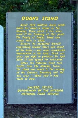
| On Natchez Trace Parkway (at milepost 128.4), 6.6 miles south of Mississippi Highway 16, on the left when traveling north. |
| Near Natchez Trace Parkway (at milepost 106.9), 3.4 miles north of Old Canton Road, on the right when traveling north. |
| Near Natchez Trace Parkway (at milepost 100.7), 0.5 miles west of Interstate 55, on the left when traveling east. |
| On Old Agency Road east of North Livingston Road, on the left when traveling east. |
| On Old Agency Road west of Highland Colony Parkway, on the right when traveling west. |
| On Marianna Road, 0.4 miles east of Pegues Road, on the right when traveling east. |
| On U.S. 278, 1.2 miles west of Cotton Gin Road, on the right when traveling west. |
| On Highland Drive (Mississippi Route 25) at Meadowbrook Circle, on the right when traveling south on Highland Drive. |
| On U.S. 278 at Cotton Gin Road, on the right when traveling east on U.S. 278. |
| On Chickasaw Drive, 0.1 miles west of Fairways Drive. |
| On U.S. 80 at Buckley Road, on the right when traveling east on U.S. 80. Reported missing. |
| On Jefferson Street (State Highway 145) 0.2 miles south of South Street, on the right when traveling south. |
| On Monument Road / Dancing Rabbit Road, 2.2 miles south of Butler Road, on the right when traveling south. |
| On Mississippi Route 21 west of Butler Road, on the right when traveling west. |
| On Mississippi Route 35N, 0.5 miles south of Interstate 55, on the right when traveling south. |
| On Black Zion Road (Mississippi Route 342) at Valley Road (County Road 853), on the right when traveling north on Black Zion Road. |
| On Black Zion Road (Mississippi Route 342) 0.4 miles east of Woodland Road (County Road 75), on the right when traveling east. |
| On Natchez Trace Parkway (at milepost 241.4), 1.6 miles south of County Road 413, on the left when traveling north. |
| On Natchez Trace Parkway (at milepost 243.3), 0.2 miles north of County Road 413, on the left when traveling north. |
| On Natchez Trace Parkway (at milepost 245.6), 1.4 miles south of Mississippi Highway 41, on the right when traveling north. |
| On North Main Street (State Highway 9) north of Warren Street, on the left when traveling north. |
| On East Washington East at South Liberty Street, on the left when traveling east on East Washington East. |
| On Mississippi Route 41 at Campground Road (County Road 134), on the right when traveling south on State Route 41. |
| On North Main Street (State Highway 9) south of Warren Street, on the left when traveling north. |
| On South Main Street at East Marion Street, on the right when traveling north on South Main Street. |
| On Natchez Trace Parkway (at milepost 251.1), 0.5 miles south of Pontocola Road (County Road 506), on the right when traveling north. |
| On Natchez Trace Parkway (at milepost 249.6), 2 miles south of Pontocola Road (County Road 506), on the left when traveling north. |
| On Toccopola Junction Road (County Highway 843) at Highway 278, on the right when traveling north on Toccopola Junction Road. |
| On Toccopola Junction Road (County Road 843) at Toccopola Road (Route 334), on the right when traveling south on Toccopola Junction Road. |
| On Nachez Trace Parkway (at milepost 286.7), on the right when traveling east. |
| On U.S. 80 east of Lindsey Road, on the left when traveling east. |
| On Creek Road, 0.3 miles west of Barfield Road, on the right when traveling west. |
| On Crab Apple Lane at Willow Lane, on the right when traveling north on Crab Apple Lane. |
| On Willow Lane at Crabapple Lane, on the right when traveling north on Willow Lane. |
| On Deer Creek Road, 0.4 miles south of State Route 16, on the right when traveling south. |
| On Rolling Fork Road south of Helena Road, on the right when traveling south. Reported missing. |
| On U.S. 61, 0.5 miles south of West Avenue, on the right when traveling south. |
| On Church Street at U.S. 49, on the right when traveling east on Church Street. |
| On U.S. 51, 0.2 miles north of Choctaw Ridge Road (County Road 204), on the right when traveling north. |
| On U.S. 49E at Old Mill Road, on the right when traveling north on U.S. 49E. |
| Near Natchez Trace Parkway (at milepost 308.8), 1.2 miles north of Mississippi Highway 30, on the left when traveling north. |
| Near Natchez Trace Parkway (at milepost 308.4), 0.8 miles north of Mississippi Highway 30, on the right when traveling north. |
| On County Road 958, 1.5 miles east of County Road 104, on the right when traveling east. |
| On Old U.S. 61, 0.8 miles south of Evansville Road, on the right when traveling south. Reported missing. |
| On Austin Road, 0.2 miles west of Old U.S. 61, on the left when traveling west. |
| On Indian Mound Road, 1.5 miles west of Old U.S. 61, on the right when traveling west. |
| On Old U.S. 61, 0.5 miles south of Hollywood Road, on the right when traveling south. |
| On State Highway 15, 0.3 miles south of South Central Avenue, on the right when traveling south. |
| On State Highway 3, 0.5 miles north of Old Highway 3, on the left when traveling north. |
| On Mississippi Route 3, 0.6 miles south of Mary Hearn Road, on the right when traveling south. |
| On Silver Bullet Boulevard near State Route 3, on the left when traveling north. Reported missing. |
| On Silver Bullet Boulevard north of State Route 3, on the left when traveling east. |
| On North Washington Street (Business U.S. 61) 1.3 miles 1st East Street, on the right when traveling north. |
| On U.S. 61 south of Demby Drive, on the right when traveling south. |
| On Grove Street at Cherry Street, on the right when traveling north on Grove Street. |
| On Levee Street north of Clay Street, on the left when traveling north. |
| On Yazoo Refuge Road, 1 mile east of State Highway 1, on the right when traveling east. |
| On Yazoo Refuge Road east of Deer Lake Road, on the right when traveling east. |
| On State Highway 1 north of Indian Road, on the right when traveling north. |
| On State Highway 1 north of Indian Road, on the right when traveling north. |
| On State Highway 1 north of Indian Road, on the right when traveling north. |
| On U.S. 82 at South Deer Creek Drive East, on the right when traveling south on U.S. 82. |
| On West Roane Avenue (State Highway 182) at South Dunn Street, on the left when traveling west on West Roane Avenue. |
| On Natchez Trace Parkway (at milepost 213.3), 1 mile south of Mississippi Highway 15, on the left when traveling north. |
| On Natchez Trace Exit Road, 0.2 miles east of Natchez Trace Parkway, on the left when traveling east. |
| On State Highway 24, 0.5 miles north of Millbrook Road, on the right when traveling east. |
| On State Highway 24 west of Pleasant Valley Road, on the right when traveling west. |
| On Mississippi Route 393, 1.3 miles north of County Road 856, on the right when traveling north. |
| On East Main Street (State Highway 490) at West Front Street, on the right when traveling east on East Main Street. Reported missing. |
| On Oklahoma Street (County Road 436) 0.1 miles north of Wortham Street, on the right when traveling north. |
170 entries matched your criteria. Entries 101 through 170 are listed above.
⊲ Previous 100