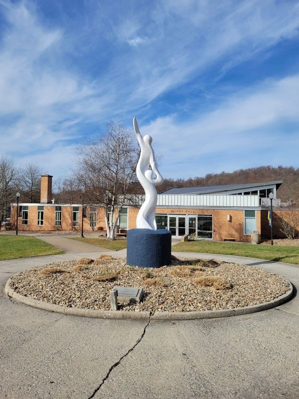
Near College Hill Road south of Circle Drive West, on the left when traveling south.
Warner's idea came from Sir Issac Newton's, "I Stand on the Shoulders of Giants." He named the statue "Apollo" in appreciation for the space program.
Alderson-Broaddus chose it for the Centennial symbol-1971-because the college's aspirations . . . — — Map (db m211831) HM
On Graystone Drive, on the right when traveling south.
After the Civil War, Barbour County residents built this one-room school house near Volga, 8 miles SW. As one of the county's first free schools, it was the center of education for hundreds of children, providing instruction for primary through . . . — — Map (db m155092) HM
On South Main Street (U.S. 250) at School Street, on the right when traveling south on South Main Street.
Laid by the Masonic Fraternity
August 6 AD 1921 AL 5921
AC Nadenbousch
Grand Master
This is the cornerstone for the Philippi grade, middle and high school that was located on this property and served Barbour County from 1921 until . . . — — Map (db m211626) HM
On College Hill Road south of Circle Drive West, on the left when traveling south.
Named for Dr. Richard E. Shearer, President of Alderson-Broaddus College, 1951-1983.
During the Shearer Administration all the buildings on this quadrangle were erected except one which was completely remodelled. New Main replaced Old Main, . . . — — Map (db m211842) HM
On West Martin Street west of Raleigh Street, on the left when traveling west.
Born 1848 in Hardy Co. A Civil War vet., Storer College graduate, teacher and principal at local Sumner School. Published Pioneer Press (1882), first African American paper in state. First of race to pass state bar exam (1887); argued two . . . — — Map (db m1210) HM
On South Queen Street (West Virginia Route 9) south of West Stephen Street, on the left when traveling north.
This High Victorian Gothic structure which served as the Martinsburg High School, now houses the Berkeley County Board of Education office. — — Map (db m132394) HM
On West Martin Street west of Raleigh Street, on the left when traveling west.
The present building was completed in 1917 under the leadership of Fred R. Ramer. He was the first principal in Berkeley County to have a school named after him. Ramer school served the black community until 1964. — — Map (db m1211) HM
On West Virginia Route 85, 0.1 miles north of Country Estates Road, on the left when traveling south.
Born in 1810 in present-day Boone
County, Methodist minister Robert
Hager was a delegate to the state’s
first constitutional convention in
Wheeling. 1861-1863. He supported
including a provision for gradual
emancipation in WV and also a . . . — — Map (db m138447) HM
On Coal River Road (West Virginia Route 3), on the right when traveling west.
Completed as Sherman District Jr.
High in 1931. Whitesville School
replaced a building that burned
down in 1929. Wysong and Bengston
designed the rare example of high-style Art Deco architecture in the
southern West Virginia coalfields.
Since . . . — — Map (db m137755) HM
Born in Prince Edward Island, Canada, September 4, 1849
Died December 15, 1920
Fourth President of Bethany College
For thirty-nine years Chief Executive of the
Foreign Christian Missionary Society
Every missionary sent to . . . — — Map (db m20836) HM
On Main Street (West Virginia Route 67) 0.2 miles east of West Virginia Route 88, on the right when traveling east.
Bethany
Here Scots-Irish Alexander Campbell founded a religious movement which he called the Disciples of Christ. In this place Amos Dolbear perfected parts of the telephone, and longtime Speaker of the House "Champ" Clark, Supreme Court . . . — — Map (db m79899) HM
On Main Street (Route 67) at Fairway Street, on the right when traveling east on Main Street.
Bethany
Bethany College, established here in 1840, oldest school of college rank in State. The home and the study of Alexander Campbell, founder, are here. Prof. A. E. Dolbear here perfected parts of the telephone, which Bell used.
. . . — — Map (db m79900) HM
On Main Street at Church Street, on the right when traveling east on Main Street.
Bethany Church of Christ, the oldest church building in Bethany, was built in 1852 according to plans drawn by Alexander Campbell, founder of Bethany College and leader in the Disciples Movement. Its foundation is built of stone from the original . . . — — Map (db m20830) HM
On Main Street (West Virginia Route 67), on the right when traveling east. Reported missing.
Here are buried the Campbell family; the first missionaries, other prominent leaders in the Disciples Movement, presidents and distinguished teachers of Bethany College. The seven foot hand hewed stonewall is a unique feature of Cemetery. — — Map (db m20963) HM
On Main Street (West Virginia Route 67), on the right when traveling east.
In this house, 8 Bethany College Students - William Cunningham, John Johnson, Alexander Earle, Richard Alfred, Eugene Tarr, Henry Bell, John Hunt and Jacob Lowe - Met in 1858 and founded Delta Tau Delta. This social fraternity soon spread across the . . . — — Map (db m20849) HM
Near College Street at Main Street (West Virginia Route 67).
A major grant from the Renner Foundation, which was matched by alumni gifts, made possible, in 1970, the complete remodeling of Bethany House built in 1948. Henry Clay and James A. Garfield were among the notable guest at the first Bethany House . . . — — Map (db m79901) HM
On Hal Greer Blvd at 9th Avenue on Hal Greer Blvd.
Historian, author, educator. Founder of the Assoc. for the Study of Negro Life & History, 1915. Began Journal of Negro History, 1916. In 1926 began Negro History Week, later Black History Month. A graduate and later principal, Douglass H.S., . . . — — Map (db m213391) HM
On 10th Avenue at Douglass Street / A D Lewis Avenue, on the right when traveling west on 10th Avenue.
Born on December 14, 1882, in
Montgomery, WV. Lavinia Norman
later attended Howard University
in Washington, DC. In 1908, with
eight other students, she founded
Alpha Kappa Alpha, the oldest
Greek-lettered organization for
African American . . . — — Map (db m125986) HM
In lasting remembrance of the members of the Marshall University Football Team, the coaches, staff, and devoted fans who died in the plane crash November 14, 1970.
They shall live on in the hearts of their families and friends forever and this . . . — — Map (db m73731) HM
On Marshall Memorial Boulevard / Charleston Avenue east of 20th Street.
On November 14, 1970, a chartered jet crashed on approach to Tri-State Airport near Huntington, claiming the lives of seventy-five members of the Marshall University football team, coaches, fans, pilots & crew. This boulevard, named in honor of . . . — — Map (db m73729) HM
On 3rd Avenue (U.S. 60) at 20th Street, on the right when traveling west on 3rd Avenue.
On November 14, 1970, a chartered jet crashed on approach to Tri-State Airport near Huntington, claiming the lives of seventy-five members of the Marshall University football team, coaches, fans, pilots & crew. This boulevard, named in honor of . . . — — Map (db m208449) HM
On 3rd Avenue (U.S. 60) at 18th Street, on the left when traveling west on 3rd Avenue.
Named for John Marshall, Chief Justice U.S. Supreme Court, 1801–1835. Founded as Marshall Academy, 1837, and chartered as Marshall College, 1858. Established as a state-supported institution, 1867. Granted university status, 1961. — — Map (db m125985) HM
On Hal Greer Boulevard (West Virginia Route 10) near 4th Avenue, on the right when traveling south.
Named for John Marshall, Chief Justice U.S. Supreme Court, 1801–1835. Founded as Marshall Academy, 1837, and chartered as Marshall College, 1858. Established as a state-supported institution, 1867. Granted university status, 1961. — — Map (db m178150) HM
On 20th Street north of 5th Avenue (U.S. 60), on the left when traveling north.
The Pi Kappa Alpha fraternity lost five brothers in the plane crash that devastated the Marshall University football team: Starting Quarterback Ted Shoebridge and Offensive Linemen Jim Adams, Mike Blake, Pat Norrell, and Bob Patterson.
To . . . — — Map (db m208664) HM
On 5th Avenue at 17th Street, on the left when traveling east on 5th Avenue.
Union School, nicknamed "Punkin Center School," was located on Guyan Creek Road near Glenwood, Cabell County. Served grades 1 thru 8 from 1899 to 1955. Schoolhouse donated by Mrs. Bill (Tina) Bryan; relocation and renovation funded by Phil Cline. On . . . — — Map (db m23026) HM
On 20th Street at 3rd Avenue (U.S. 60), on the right when traveling north on 20th Street.
"We Are...Marshall" Memorial Bronze presented to Marshall University on the Eleventh day of November in the year 2000 as a tribute to those lost on November 14, 1970.
The memorial will stand for all time as a symbol of community resilience . . . — — Map (db m208903) HM
Rev. Charles McGee chartered WV Normal Industrial School for Colored Orphans, 1899. Opened, Central City, 1900, moved to 190-acre farm near Huntington & Guyandotte R. Served African-American orphans and indigent. Bought, 1911, operated until 1956 . . . — — Map (db m73742) HM
On Main Street (West Virginia Route 16) east of Locust Street, on the right when traveling east.
Born on December 10, 1826, he was
one of the first school teachers
in Nicholas County. He moved to
Clay County before the Civil War
and was a delegate to the first
constitutional convention for West Virginia,
1861-1863. In 1863, he organized . . . — — Map (db m137965) HM
On July 26, 1942 the first African American 4-H camp in the United States was opened here in Fayette County. A 1929 report showed that 44 of the state’s 55 counties had 4-H camps for white children, hut none for black children. Fleming Adolphus . . . — — Map (db m138104) HM
On Fayette Pike West (West Virginia Route 61) 0.3 miles east of Jackson Street, on the right when traveling east.
State institution established in 1895 as Preparatory Branch of West Virginia University. In 1931, name was changed to New River State College. Became a multipurpose college in 1941, known as West Virginia Institute of Technology. — — Map (db m76933) HM
On West Virginia Route 16 north of Virginia Street, on the right when traveling south.
An African American high school
formed in 1917, it educated black
Fayette County children until 1956.
Students were taught in community
buildings and churches, 1950-1954,
after the school was destroyed by
fire. The second DuBois High . . . — — Map (db m140445) HM
On High School Drive east of State Route 16/61, on the right when traveling east.
In 1906 a levy was passed in Fayette County to establish the county's first high schools, one for white children and one for black children. The original school for African American children was constructed at Turkey Knob, but was later replaced . . . — — Map (db m242569) HM
On Main Street (West Virginia Route 211) 0.2 miles west of Route 16, on the right when traveling east.
A cadre of excellent teachers sharing and imparting values produced students with interests and community endeavors, fundraising, and contributions to projects throughout the world.
Leadership – Principals
see photo
. . . — — Map (db m161345) HM
On Main Street (West Virginia Route 211) 0.2 miles west of West Virginia Route 16, on the right when traveling east.
By 1872 there were only three families, that of C.C. Brown, the Warner's and the McGinnis’ living in the area now known as Mount Hope. They built a one room wooden schoolhouse replacing the first school held in the Blake Ian kitchen and in a tenant . . . — — Map (db m161276) HM
On Lynn Street (County Road 5/3) 0.1 miles north of North Court Street, on the right when traveling south.
The clock tower, affectionately known as the "light house on the hill", was constructed in 1899 where the bell had rung from the top of the Administration building. Several years later in 1953, Roy Clemons was hired by President Harry Heflin to work . . . — — Map (db m190034) HM
A college that offers both professional and general education with emphasis on teacher education was established by the Legislature in 1872 as the Glenville Branch of the West Virginia Normal School. Became Glenville State Normal School in 1898. . . . — — Map (db m73429) HM
On Linn Street (County Road 5/3) 0.2 miles north of North Court Street, on the right when traveling south.
Thomas Marcellus Marshall, Glenville State Normal, Acting Principal - January 1873-June 1873; Principal - 1875-1881 •
Louis Bennett, Glenville State Normal, Principal - 1873-1875 •
Robert Franklin Kidd, Glenville State Normal, Principal . . . — — Map (db m190029) HM
On Lynn Street, on the right when traveling north.
Over 292,000 Americans died in defense of their country
during World War II. Glenville State College lost 23 students
whose names are engraved on this memorial.
1st. LT. Elmer R. Cawthon, Jr. De Ridder, Louisiana April, 1943 •
Lt. (jg) . . . — — Map (db m190025) WM
A central West Virginia college maintained for the training of grade and high school teachers. Established as a normal school in 1872 by the Legislature. Given college status in 1930. — — Map (db m73430) HM
On North Monroe Street north of Walnut Avenue, on the right when traveling north.
Alderson Academy opened September 18, 1901, a coeducational secondary school founded mainly through the efforts of Miss Emma C. Alderson. Closely associated with Greenbrier Baptist Church, after 1910 control was assumed by W. Va. Baptist . . . — — Map (db m76519) HM
Carnegie Hall, built in 1902, by Lewisburg Female Institute and citizens of the Greenbrier Valley area. It is one of only three Halls in the U.S. named for Andrew Carnegie who gave $26,750. Local citizens gave $10,000 to complete the Hall. . . . — — Map (db m61464) HM
On Church Street at West Foster Street, on the right when traveling south on Church Street.
Site of the campus of Greenbrier College. In 1812, the Rev. John McElhenney established a co-ed school, the Lewisburg Academy. In 1875, the academy transferred all properties to the Lewisburg Female Institute. Briefly named Lewisburg Seminary prior . . . — — Map (db m140673) HM
First established at Lewisburg 1808-09 by Dr. John McElhenney and chartered as an academy in 1812. Used as barracks and hospital during War between the States. Present buildings on north side of town built 1921. — — Map (db m19378) HM
On U.S. 219 at Greenbrier Ave., on the right when traveling north on U.S. 219.
First school was established 1808-09 by Dr. John McElhenney and chartered as an academy in 1812. Used as barracks and hospital during War between the States. The present buildings were erected in 1921. — — Map (db m19382) HM
On Courtney Drive at Washington Street (U.S. 60) on Courtney Drive.
Side A Site of Fort Savannah, built in 1755. Here at Camp Union Gen. Andrew Lewis mustered troops which participated in the Battle of Point Pleasant 1774. Lewisburg was incorporated in October, 1782, by the Virginia Assembly. Side B . . . — — Map (db m21747) HM
In recognition of the foresight of the Honorable Senator Robert C. Byrd whose leadership efforts on behalf of improved health care for West Virginians and enhanced training opportunities for WVSOM students made this facility possible — — Map (db m243853) HM
Near Cold Stream Road (County Road 15) just north of Henderson Lane, on the right when traveling north.
This walking trail, opened on June 25, 2011, is dedicated to the life and memory of Kenneth Edmonds, a principal founding member and first president of The Fort Edwards Foundation in 1995. Ken, a retired businessman, artist, neighbor and friend, . . . — — Map (db m150671) HM
Mechanicsburg Gap
Scenic canyon cut through Mill Creek Mountain by Mill creek. Here an old Indian trail was the pathway from the Valley of Virginia to the Alleghenies, then the Northwestern Turnpike, now the George Washington Highway
Col. . . . — — Map (db m19355) HM
On South High Street (West Virginia Route 28) at Main Street (U.S. 50) on South High Street. Reported missing.
Literary Society of Romney organized in 1819, oldest in the state and one of the first in America. A splendid Public Library was accumulated which by 1850 was the largest in West Virginia. Destroyed during the War Between the States in 1862. . . . — — Map (db m203678) HM
On East Main Street (U.S. 50) at Administration Circle, on the left when traveling east on East Main Street.
Established, 1870. The Classical Institute was donated by the Romney Literary Society as the initial building unit. Co-educational school giving academic and vocational training to the State's deaf and blind youth. — — Map (db m459) HM
On North River Avenue at Jefferson Street, on the right when traveling south on North River Avenue.
Located beside courthouse, original building of four rooms built in 1869, opened in 1870 with town hall on 2nd floor. In 1888 two wings were added. By 20 January 1939, when destroyed by fire, had 14 rooms with 500 students. Rebuilt on same site, it . . . — — Map (db m44126) HM
On South Fork Road (County Route 7) 16.7 miles north of U.S. 33, on the right when traveling north.
Last of the Lutheran horseback circuit rides, who was known as a dynamic pastor, theologian, professor of history, philologist and a Christian gentleman.
Died 1952 A.D. — — Map (db m49580) HM
On South 2nd Street at West Pike Street (West Virginia Route 20), on the right when traveling north on South 2nd Street.
Built in 1894 and named in honor of Reverend George Towers, graduate of Oxford, England who was a teacher at Randolph Academy. The Academy, authorized by the Virginia Assembly in 1787, stood just to the east and was the principal regional school . . . — — Map (db m73405) HM
On West Main Street, 0.1 miles east of West Virginia Avenue, on the right when traveling east.
Chartered, 1794, and settled by colony of families from New Jersey. Site of blockhouse where troops were stationed during Indian wars to guard the trail from the Ohio to the West Fork settlements. It is the seat of Salem College. — — Map (db m170909) HM
On Haywood Road (West Virginia Route 20) just west of Shinnston Pike (U.S. 19), on the right when traveling west.
From 1922 to 1933, WV State Police training facilities and Company A headquarters were located at a camp in Haywood Junction. Not only were troopers trained, but horses were broken using proven methods of the U.S. Cavalry. In the late 1920s, . . . — — Map (db m176749) HM
On South West Street at West Congress Street, on the right when traveling south on South West Street. Reported permanently removed.
The first school for African-Americans in Charles Town started in December 1865 at the home of Achilles and Ellen Dixon, African-Americans who lived on Liberty Street. It was taught by Freewill Baptist Missionary Anne Dudley.
Between 1868 . . . — — Map (db m132452) HM
On Congress Street at Charles Street, on the left when traveling west on Congress Street.
Following the election in 1846, Jefferson County became one of the first counties in Virginia to approve free schools for white students. Prior to that time boys and girls paid to attend private academies. The county was divided into 27 districts . . . — — Map (db m103644) HM
On Congress Street west of George Street (West Virginia Route 115), on the left when traveling west.
In 1799, prominent Charles Town resident Samuel Washington sold the two lots that house this building to James Duke, a freed indentured servant. Eventually, physician Charles Taylor Richardson took ownership of the land and property. Dr. Richardson . . . — — Map (db m103606) HM
On Congress Street west of George Street (West Virginia Route 115), on the left when traveling west.
Etter Hall is named after American Public University System's (APUS) founder, Major James P. Etter. Major Etter served in the United States Marines for twenty-one years. He served two tours in Vietnam and received two Purple Hearts. Major Etter . . . — — Map (db m103607) HM
On E Washington Street (U.S. 340 Bus) at N George Street, on the right when traveling west on E Washington Street.
Jefferson County, Virginia placed this stone originally in a schoolhouse near Shepherdstown as a tribute to · · John Yates · · The founder of the Free School System in this county Moved to its present location 1937. [ Lower Marker: . . . — — Map (db m41726) HM
On West Liberty Street at North Lawrence Street, on the right when traveling east on West Liberty Street.
Martin Robison Delany was born in Charlestown, Virginia (now Charles Town, West Virginia) on May 6, 1812. His mother, Patti Peace was a free black woman. She married an enslaved man from Berkeley County named Samuel Delany. They had five children . . . — — Map (db m132450) HM
On East Liberty Street west of North Samuel Street, on the right when traveling east.
On these grounds stood the first school for "colored" in Jefferson County. In 1867, the Freedmen's Bureau established this school at the home of Achilles Dixon, a blacksmith. Its first teachers were Annie Dudley and E.H. Oliver. It remained a school . . . — — Map (db m132446) HM
On Shenandoah Street at Potomac Street, on the right when traveling east on Shenandoah Street.
"The War That Ended Slavery"
Abolitionist Frederick Douglass, from his 1881 Storer College Commencement speech
"I want to free all the negroes in this [slave] state ... if the citizens interfere with me I must only burn . . . — — Map (db m143940) HM
Female students arriving here at the Cook Hall dormitory were greeted with a welcoming letter that advised them, “Here you will come as a refuge from the strangeness or perplexities of campus life. Here you will fight your battles of . . . — — Map (db m70830) HM
On Fillmore Street at Lancaster Street, on the right when traveling east on Fillmore Street.
Built in 1858, this house served as the home for the U.S. Armory superintendent's clerk. As an assistant to the superintendent, the clerk's responsibilities included drafting correspondence, filing reports, arranging schedules, and insuring the . . . — — Map (db m70779) HM
On Fillmore Street at Storer College Place, on the left when traveling east on Fillmore Street.
You are in the Camp Hill area of Harpers Ferry. Explore Camp Hill's history with exhibits in front of the Morrell, Brackett, and Lockwood houses and Mather Training Center. Side trails in Harper Cemetery and in front of Mather Training Center . . . — — Map (db m103584) HM
Harpers Ferry, including Anthony Hall (to your left), played host to large and small scenes in the epic human struggle for freedom and equality. In this building, the superintendent of the national armory contemplated how to strengthen the . . . — — Map (db m70797) HM
On Fillmore Street, on the right when traveling east.
Harpers Ferry, including Anthony Hall (behind you to the right), played host to large and small scenes in the epic human struggle for freedom and equality. In this building, the superintendent of the national armory contemplated how to . . . — — Map (db m70821) HM
On Mather Place, 0.1 miles south of Hartzog Drive when traveling south.
Harpers Ferry, including Anthony Hall (to your left), played host to large and small scenes in the epic human struggle for freedom and equality. In this building, Civil War generals planned their next attack. In the fields around you, Union and . . . — — Map (db m158638) HM
A national controversy regarding the education of African American students played out in the building before you. Throughout its history, Storer College faced great difficulty attracting funding. Most white benefactors favored trade school . . . — — Map (db m70807) HM
Near Fillmore Street at Hartzog Drive, on the right when traveling east.
We want our children trained as intelligent human beings should be and we will fight for all time against any proposal to educate black boys and girls simply as servants and underlings, or simply for the use of other people. They have . . . — — Map (db m173635) HM
Near Fillmore Street, 0.1 miles east of Columbia Street.
With its commanding view of Harpers Ferry and the Potomac River gap, this house has witnessed significant chapters in Harpers Ferry's history. It was built in 1847 as quarters for the U.S. Armory paymaster and later served as headquarters for Union . . . — — Map (db m238060) HM
On Fillmore Street east of Columbia Street, on the right when traveling east.
This house was built in 1858 as quarters for the U.S. Armory paymaster's clerk and his family. This clerk helped the paymaster manage the armory's complex budget and payroll, and assisted also with the collection of government quarters' rent and . . . — — Map (db m70750) HM
Near Fillmore Street at Storer College Place, on the right when traveling east. Reported permanently removed.
Thousands of blacks seeking refuge from slavery and protection behind Union lines fled to Harpers Ferry during the Civil War.
Recognizing the importance of education for former slaves, the government’s Freedmen’s Bureau began a school here . . . — — Map (db m238230) HM
On McDowell Street just south of Fillmore Street, on the left when traveling north.
Female students arriving here at the Cook Hall dormitory were greeted with a welcoming letter that advised them, "Here you will come as refuge from the strangeness or perplexities of campus life. Here you will fight your battles of adjustment to . . . — — Map (db m158640) HM
Near Fillmore Street at Storer College Place, on the right when traveling east.
We claim for ourselves every single right that belongs to a freeborn American, political, civil and social, and until we get these rights we will never cease to protest and assail the ears of America. The battle we wage is not for . . . — — Map (db m173631) HM
On Route 9 Bike Path, 0.7 miles north of Leetown Road (County Road 1), on the right when traveling south.
Traveller's Rest
Traveller's Rest is the site of a pre-Revolutionary War, 1½-story limestone dwelling and several log, wood frame, and masonry outbuildings. The property is listed in the National Register of Historic Places and . . . — — Map (db m150614) HM
On Princess Street, on the right when traveling south.
Shepherd District Free School 1848-1881Given to the West Virginia board of education for Shepherd College by Upton S. Martin in memory of his father, U.S. Martin (1859-1957), 32nd degree mason, Mayor of Shepherdstown six years, member West . . . — — Map (db m23845) HM
On W. German Street near Church Street, on the right when traveling east.
This house was acquired in 1995 by actress Mary Tyler Moore, a descendant of Conrad Shindler, and donated to the Shepherd College Foundation in honor of her father, George Tyler Moore. Between 1869 and 1995, this house served as the Reformed Church . . . — — Map (db m98159) HM
On South Duke Street (West Virginia Route 480) at Shepherd Grade Road, on the right when traveling west on South Duke Street.
Shepherd College. Incorporated as Shepherd College, 1871. Chartered by act of the Legislature, Feb. 27, 1872, as the Shepherd College State Normal School. Name changed in 1931 to Shepherd State Teachers College and in 1943, to Shepherd . . . — — Map (db m143926) HM
On German Street (West Virginia Route 230) at King Street (West Virginia Route 480), on the right when traveling west on German Street.
Established in 1872 as a branch of the State normal school system. It was an outgrowth of the old Shepherd College. This is the site of early settlement made by Thomas Shepherd who built a fort here during Indian days. — — Map (db m1938) HM
On North King Street (Route 480) 0.3 miles east of Shepherd Grade Road, on the right when traveling east.
Shepherdstown, the oldest town in what is now West Virginia was incorporated as Mecklenburg in 1762, but was renamed Shepherd's Town in 1798 in honor of its founder Thomas Shepherd. From the French and Indian War to the Civil War the town has been . . . — — Map (db m143927) HM
On North King Street (County Road 480/2) just south of East High Street, on the right when traveling north.
In memory of
Henry Luckett Clapham • Ira Moser Derr • Thomas Franklin Ewers • John Chrisman Goghenour • Washington Berry Grove • Marshall Earle Martin • Wilmer Birdie Miller • Garnett Otis Nelson • Hubert Monroe Phares • Joseph Rodney Power • . . . — — Map (db m157757) WM
On East Dupont Avenue (U.S. 60) at Woodmont Cemetery Drive, on the right when traveling south on East Dupont Avenue.
Founder and defender of Fort Morris, the first fort built on the Great Kanawha River in 1774, near this site. He also built the first church and school house and made the first permanent white settlement in the Great Kanawha Valley.
And of . . . — — Map (db m164712) HM
Near Kanawha Boulevard East (U.S. 60) 0.1 miles east of Greenbrier Street.
1856 - Born a lowly slave;
1915 - Died a great American.
Famous educator, author, lecturer and advocate of the doctrine of interracial cooperation.
Booker T. Washington was born near Hale's Ford, Franklin, County, VA. He spent his . . . — — Map (db m227472) HM
On Morris Street at Quarrier Street, on the right when traveling north on Morris Street.
On this site stood Charleston High School Built in 1915 and designed by Frank Packard, architect. In 1926 a larger CHS was constructed, and this building became Thomas Jefferson Junior High School until 1978. An embodiment of community memory, it . . . — — Map (db m228735) HM
On Kanawha Boulevard West just east of Florida Street, on the right when traveling east.
Born in Ohio in 1848, Davis served during the Civil War in the Union Light Guard of Ohio that was tasked with protecting President Lincoln. After the war, he moved to present-day Malden and later Charleston, where he served as an educator. His . . . — — Map (db m178787) HM
On Third Avenue (Route 61) at Walnut Street, on the right when traveling west on Third Avenue.
Built as Cabin Creek District H.S. in
1912;
name was later changed to East
Bank H.S. Served the upper Kanawha
Valley for eighty-seven years before
1999 consolidation with Dupont H. S.
to form Riverside H. S. College All-American, Jerry West, . . . — — Map (db m137843) HM
Near Washington Avenue just north of Chestnut Avenue, on the right when traveling south.
Jewels
Henry Arthur Callis •
Charles Henry Chapman •
Eugene Kinckle Jones •
George Biddle Kelley •
Nathaniel Allison Murray •
Robert Harold Ogle •
Vertner Woodson Tandy
Established By
Harry S. Blackiston •
James E. . . . — — Map (db m178749) HM
Near Fairlawn Avenue (West Virginia Route 25) 0.1 miles east of Barron Drive, on the right when traveling east.
President Hemphill, 2012-2016 served with unwavering passion and inspired a campus-wide focus on excellence, accountability and student-centeredness through rebranding, marketing and community engagement.
He led the effort to implement new . . . — — Map (db m178733) HM
Near Fairlawn Avenue (West Virginia Route 25) 0.1 miles east of Barron Drive, on the right when traveling east.
President Prillerman, 1909-1919, enjoyed tremendous success in advancing the institution. He developed an outstanding agricultural program, changed the name to West Virginia Collegiate Institute, offered the first college courses, provided extension . . . — — Map (db m178722) HM
262 entries matched your criteria. The first 100 are listed above. Next 100 ⊳