On East Main Street (Indiana Route 111) close to Bank Street, on the right when traveling west.
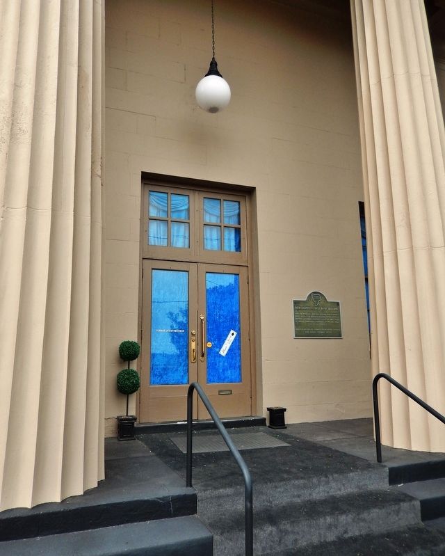
Built in 1837 this building housed New Albany’s First Bank — a branch of the State Bank of Indiana. Of Greek Revival style, it was built of native limestone quarried from the hills of Floyd County. — — Map (db m193690) HM
On East Main Street (Ohio River Scenic Byway) (Indiana Route 111) just east of East 7th Street, on the right when traveling west.
Originally John R. Nunemacher, a contractor, built a “cottage with a basement”; however in 1876 Edward C. Hangary added the unique “New Orleans” façade and the top floor. The wrought iron fence was manufactured in New Albany and extended to 7th . . . — — Map (db m194195) HM
On East Main Street (Indiana Route 111) at State Street, on the right when traveling east on East Main Street.
The first frame house in New Albany, built by Joel Scribner, one of the city’s founders. Purchased in 1917 from his grand-daughter, Miss Harriet Scribner, by Piankeshaw Chapter Daughters of the American Revolution. — — Map (db m241983) HM
On East Main Street (Indiana Route 111) at Bank Street, on the right when traveling west on East Main Street.
Second state bank was established in 1834 by General Assembly with ten branch banks; one of the most successful banks at the time in U.S. This Greek Revival Style structure, built 1837, housed New Albany branch, serving Floyd, Harrison, Washington, . . . — — Map (db m180504) HM
On East Main Street (State Road 111) at East 10th Street, on the right when traveling east on East Main Street.
Built by William S. Culbertson, one of Indiana's pioneer industrialists and cotton merchant. There are 5 houses in New Albany built by Mr. Culbertson for his family, this is the grand mansion and exceptional in every respect. The building was . . . — — Map (db m207011) HM
On West Main Street (Indiana Route 111) west of West 1st Street, on the right when traveling west.
During the 1840-1860 period this hotel and restaurant was the congregating place for men of commerce and industry. In addition to River Captains and their families notable visitors were: Gen. Winfield Scott, Daniel Webster, Andrew Jackson, Martin . . . — — Map (db m194196) HM
On East Main Street (State Road 111) at East 14th Street, on the right when traveling east on East Main Street.
formerly the
M. Fine & Sons shirt factory
has been placed on the
National Register
of Historic Places
by the United States
Department of the Interior — — Map (db m207001) HM
On East Spring Street east of East 6th Street, on the left when traveling east.
Originally built for James Mitchell and sold to Simeon K. Wolf in 1896. Three years later Mr. Wolf was elected to Congress. The transfer read, 'purchased the princely colonnaded residence'. In 1904 Dr. Elihu P. Easley purchased the property. Since . . . — — Map (db m207013) HM
On East Main Street (State Road 111) west of East 14th Street, on the right when traveling west.
Built by John Crawford, brother of the master builder, and later builder of many fine homes in New Albany. Dr. W.F. Morrill and his wife, a daughter of Mr. Crawford's, lived here till his death at the turn of the century. Notable visitor was Ralph . . . — — Map (db m207003) HM
On East Main Street at East 6th Street, on the right when traveling east on East Main Street.
Built in 1852 by Dr. John Sloan as a residence and office. Dr. Sloan and family lived here until his death April 10, 1898. Survived by a daughter, Anna, and her husband Admiral George Bicknell. Judge & Mrs. John M. Paris bought the house from Adm. . . . — — Map (db m207014) HM
On E. Washington Street near South Perry Street, on the left when traveling west.
Historic Landmarks of Fountain County
Award presented to
Dr. Peter and Ann Petrich
for the Restoration and Preservation of This
Italianate Style House built c. 1850 — — Map (db m7969) HM
On 4th Street north of Liberty Street, on the left when traveling north.
Fountain County Court House
1937
has been placed on the
National Register of Historic Places
by the United States Department
of the Interior — — Map (db m37241) HM
On North Mill Street, on the right when traveling north.
HISTORIC LANDMARKS
OF FOUNTAIN COUNTY, INC.
Award
Presented to
BOOE - INLOW - D'ARLIER
CHARITABLE FOUNDATION
for the restoration
and preservation of the
Prairie / Craftman House
D'Arlier Cultural Center
Built in . . . — — Map (db m19174) HM
On North Main Street south of 2nd Street, on the left when traveling south.
Historic Landmarks of Fountain County
Award presented to
Lee and Mike Ramsey
for restoration and preservation of
115 North Main Veedersburg, IN
Built 1886 — — Map (db m9010) HM
On East 10th Street, on the right when traveling east.
Governor of Indiana, 1825 ~ 1831. Erected this house circa 1821 ~ 1822. Palladian window and transom fan~light considered "too aristocratic" by early Hoosiers. — — Map (db m94157) HM
On North Hart Street just south of West State Street, on the right when traveling south.
The site of the town of Princeton was chosen as the county seat in 1814 by county commissioners William Prince, Robert Elliott, Abel Westfall, and William Polk. On February 14, 1814, the name Princeton was chosen by the commissioners, casting lots . . . — — Map (db m190739) HM
On North Hart Street just north of West Broadway Street (Indiana Route 65), on the left when traveling north.
Structures on State, Broadway, Water, Hart, and Main Streets comprise the Courthouse Square Historic District. Commercial development on the courthouse square resulted in part from Princeton's position as a transportation center for the area. In . . . — — Map (db m190738) HM
On West Broadway Street (Indiana Route 65) at North West Street, on the left when traveling east on West Broadway Street.
Gibson County was formed in 1813 from the southwestern portion of the Indiana Territory. Once the wheels of county government began turning, the push to locate a county seat was imminent. The settlement of Patoka had been selected for the seat, but . . . — — Map (db m190591) HM
On West Broadway Street (Indiana Route 65) at North West Street, on the left when traveling east on West Broadway Street.
2014 marks the Bicentennial Celebration of Princeton, along with a period of great civic improvements. Princeton's mission statement is, "To provide residents, visitors & the business community with the highest quality municipal services in an . . . — — Map (db m190736) HM
On West Brumfield Avenue at North West Street, on the right when traveling west on West Brumfield Avenue.
The Brownlee Addition Historic District is located along West Spruce and
West Walnut Streets between North West Street and Brownlee Avenue. Most
of this district was originally owned by Robert W. Evans. On April 15, 1828
Judge Samuel Hall, who . . . — — Map (db m226445) HM
Near West Water Street near South Main Street, on the right when traveling west.
The South Princeton Historic District is a three-block area of predominately
residential structures. This district is located on South Hart, South Main, and
West Water Streets just south of the courthouse square. A broad range of
architectural . . . — — Map (db m226489) HM
On West 4th Street (Indiana Route 18) near South Garfield Street, on the right when traveling east. Reported damaged.
Samuel Plato (circa 1882-1957), African American architect and contractor, lived in Marion (circa 1903-1921). House here attributed to him; he also designed and built structures throughout the U.S. One of few black architects to win federal . . . — — Map (db m238486) HM
On South Adams Street, on the right when traveling north.
Thanks to Hoosier AM/FM radio and two anonymous donors who have helped us turn back the dial to
broadcast to the world the incredible accomplishments of builder Samuel Plato.
SAMUEL PLATO played a large role in shaping Marion's skyline in the . . . — — Map (db m215246) HM
Near Eller Road at East 106th Street, on the right when traveling south.
The Ambassador House was built as a log structure c. 1826 by Thomas and Sarah West. Around 1895, Addison and India Harris enlarged the home and built the stone pillars and outbuilding. Addison served as U.S. Ambassador to Austria-Hungary from . . . — — Map (db m231486) HM
On 9th Street at Logan Street, on the right when traveling north on 9th Street.
Built in the 1880s by Margaret Allison, this building housed a jewelry store in the 1880s and a cigar factory in the 1890s. The carrara glass facade on the first floor is a unique feature in downtown Noblesville. — — Map (db m27840) HM
On Conner Street (State Road 32/38), on the right when traveling east.
This three-unit block was built in 1884 by H. M. Caylor as a dry goods store. Typical of Victorian Gothic style, second-story details feature decorative arched stonework around the windows and the Corbel table bearing the Caylor name. — — Map (db m27886) HM
On Monument Street at North 10th Street, on the right when traveling west on Monument Street.
This property
has been placed on the
National Register
of Historic Places
by the United States
Department of the Interior
Cole-Evans house
c. 1840 — — Map (db m231460) HM
On Logan Street east of North 10th Street, on the right when traveling east.
Hamilton County formed 1823. Noblesville platted 1823, selected county seat 1824, incorporated 1851. Located east of downtown commercial area; boundaries are Conner and Logan streets (east and west) and 10th and 17th streets (north and south). . . . — — Map (db m240) HM
Built by Daniel Craycraft in 1889, this Queen Anne building housed Meade Vestal's law office. Vestal was a prominent Democrat and Circuit Court judge. The second floor loggia is unique for a commercial building. — — Map (db m27842) HM
On South 9th Street at Maple Avenue, on the left when traveling south on South 9th Street.
In 1897 the cornerstone was laid to this gothic revival church, home until 1989 of the county's oldest Christian congregation. Designed by architects Wing & Mahurin, it showcases a central rosette window and 6-story bell tower. — — Map (db m232628) HM
On 9th Street at Logan Street, on the right when traveling north on 9th Street.
Moving from a modest first floor site on Logan Street, this “modern banking house” was constructed in 1910 as the first new building of the decade. It features a limestone facade and ionic pilisters (sic) in the neo-classical style. — — Map (db m27917) HM
On North 10th Street south of Harrison Street, on the right when traveling south.
This property
Harrell House
has been placed on the
National Register
of Historic Places
by the United States
Department of the Interior — — Map (db m231466) HM
On Conner Street (State Road 32/38), on the left when traveling east.
The long-standing carriage & wagon manufactory of Heylmann & Sons had its beginnings here. Built in 1872, it is one of downtown's oldest remaining structures. A facade remodeling in 1918 updated it for a new tenant, the gas company. — — Map (db m27888) HM
On Conner Street (State Road 32/38), on the left when traveling east.
Built in 1898, this Chicago school style facility was home to a growing carriage business. It features a system of ramps connecting three levels. From 1935-1999, Hudler Press printed weekly editions of The Noblesville Times. — — Map (db m232620) HM
On South 8th Street at Maple Avenue, on the right when traveling south on South 8th Street.
Restoration made possible by the Hamilton County Visitor
and Convention Commission, the City of Noblesville
and the U.S. Department of the Interior,
National Park Service's Historic Preservation Fund
administered by the Indiana Department . . . — — Map (db m231481) HM
Constructed in 1888 by Albert H. Lacy, this building appears to be 4 stories, but the blind windows mask a decked roof. The tenants have included a hardware store for over 100 years and the Knights of Pythias for over 40 years. — — Map (db m27862) HM
On Conner Street (State Road 32/38) at 9th Street, on the left when traveling east on Conner Street.
This brick structure was built as two buildings in the late 1880s. Around 1920 they were modified with the single facade. Occupants included a hardware store, pool hall, and the New York Store Company, a large department store. — — Map (db m27883) HM
On Hannibal Street west of South 8th Street, on the right when traveling west.
This brick home was built
c.1864 by Leonard Wild for Mr.
Wilson on the site of William
Conner's 1837 town house. It is
a classic example of T-plan
Italianate architecture exhibiting
ornate ironwork and fine
interior woodwork. — — Map (db m231482) HM
On 9th Street at Maple Avenue, on the left when traveling south on 9th Street.
In 1915 George C. Richwine built a combination apartment house and business block on the site of his home and buggy shop. Then considered a monstrosity, this unusual California mission style glazed brick building is revered today. — — Map (db m27889) HM
Site of the First Presbyterian Church from 1850-1903, this building was erected in 1904 by Stella Shirts. A central staircase between two ground-floor retail spaces leads up to four offices that retain much original woodwork. — — Map (db m27890) HM
On Allisonville Avenue at Covered Bridge Way, on the right when traveling west on Allisonville Avenue.
Potter's Bridge was built in 1871 by Josiah Durfee of Noblesville for a mere $13,000. It connects the land called "Potter's Ford,” named for William A. Potter (1838-1883) who owned and farmed the surrounding land.
Why Were Bridges . . . — — Map (db m163077) HM
On West Main Street, on the right when traveling west.
The architect recognized for this design is George William Gordon (1872-1935), a Greenfield resident. Gordon is also responsible for the designs of many other Hancock and surrounding county establishments, ie: churches, schools and residences. The . . . — — Map (db m241675) HM
On West Main Street, on the left when traveling east.
John Henry Felt, a Hancock County native and a classmate of James Whitcomb Riley, studied at the International Correspondence School. He was working at a lumber factory when he began studying architecture through correspondence courses and became a . . . — — Map (db m241673) HM
On West Main Street, on the right when traveling west.
The Masonic Temple was built in 1895. The building has 3 stories and was built from Indiana limestone. Originally, the Masonic Temple housed Ward Walker & Co. clothing store and general mercantile and Goodman's Department Store on the first floor, . . . — — Map (db m241676) HM
On West Main Street, on the left when traveling east.
Born: Indianapolis, Indiana Background: - Graduate of Indianapolis High School, class of 1893 - Graduate of University of Pennsylvania School of Architecture, class of 1896 - Graduate of Ecole des Beaux Arts in Paris in 1901 - Joined . . . — — Map (db m241677) HM
On East Chestnut Street, on the right when traveling east.
This Italianate structure is another Corydon building constructed in 1894 by the Bulleit family. Originally, the Bulleit Building was part of the V.H Bulleit & Sons implement and carriage showroom. Over the years, many businesses were located here. . . . — — Map (db m241753) HM
On East Chestnut Street at North Mulberry Street, on the left when traveling east on East Chestnut Street.
This Art Deco style garage was opened by the Victor H. Bulleit Company on May 12, 1921. Its architecture is rated outstanding by Indiana Historic Landmarks. The garage was constructed by J. Fred Biggs of Scottsburg who built several other . . . — — Map (db m241754) HM
On Old Hwy 135 (Indiana Route 337) at Cedar Glade Avenue, on the right when traveling north on Old Hwy 135.
House built by Jacob Kintner, Sr. 1808. Named for giant native red cedars in area. Self-sustaining plantation traded 1849 to Thomas McGrain, Sr. for Louisville property. Sheltered Corydon residents July 1863 during Morgan’s Raid. First marked 1966 . . . — — Map (db m126306) HM
On North Capitol Avenue, on the left when traveling north.
This building was constructed by F.A. Bulleit (1876-1935) in 1895. Various businesses located here including a pool room, bowling alley, skating rink and a pub. The Dream Theatre moved here in October 1930 from its original location in the . . . — — Map (db m241740) HM
On East Beaver Street, on the right when traveling east.
Harbin Applegate constructed the building in 1865. The Griffin & McGrain Dry Goods Store operated here until they moved to the corner of Beaver and Elm Streets. Patrick Griffin established Griffin's Dry Goods Store here in 1897. In 1924 the north . . . — — Map (db m241762) HM
On North Capitol Avenue west of West Chestnut Street, on the left when traveling north.
This Neo-Classical building, with the north section constructed in 1910 by the Corydon National Bank, has been rated outstanding by the Historic Landmarks Foundation. After the bank folded in 1922, the Old Capital Bank & Trust Company purchased the . . . — — Map (db m241737) HM
On East Chestnut Street, on the right when traveling east.
This building was constructed in October 1926 for the Old Capital Restaurant which was operated by Tom Brandenburg (1888-1957) and his sister, Miss Dora Hull (1878-1966). In May of 1945, Herbert Habermel bought the building and opened a drug store. . . . — — Map (db m241747) HM
On East Chestnut Street at Old Highway 135, on the left when traveling east on East Chestnut Street.
To long-time Corydon residents, the Shafer Building always will be known as "Jocko's." In 1949, Austin "Jocko" Timberlake (1908-1972) opened Jock's Lunch, which grew to be an iconic spot in Corydon and Harrison County. Affectionately called . . . — — Map (db m241743) HM
On South Indiana Street at East Broadway Street on South Indiana Street.
(Side one):
At May 1902 meeting newly-formed Library Board authorized lot purchase and tax levy to support a public library as required by philanthropist Andrew Carnegie for funding. Designed by S. C. Dark of Indianapolis in Classical . . . — — Map (db m238) HM
On East Broadway Street at South Wayne Street, on the right when traveling west on East Broadway Street.
This property
has been placed on the
National Register
of Historic Places
by the United States
Department of the Interior
Built 1858 by
Jeremiah & Ann Jane DePew — — Map (db m231795) HM
On South Washington Street at West Broadway Street, on the left when traveling north on South Washington Street.
Harlan Carter • Martin Gregg • John Robbins
Hendricks County Commissioners
Renovated 1996
Brandt Construction Company
J.D. Clampitt • Hursel Disney • Richard Myers
Hendricks County Commissioners . . . — — Map (db m232174) HM
On West Main Street (U.S. 36) at East Street, on the right when traveling east on West Main Street.
• The west end of the original 1824 Danville plat
• Property acquired in 1894 by William W. Leachman
• House built in 1900
• Carriage House and stable built in 1907
• Longest Owner/Arlando Clay Underwood 1919-25, 1929-53
• . . . — — Map (db m232184) HM
Near North Adams Street north of East Carey Street, on the left when traveling north.
Built 1876 Listed 1976
has been placed on the
National Register
of Historic Places
by the United States
Department of the Interior — — Map (db m221880) HM
On Broad Street (State Road 38) at South Main Street, on the right when traveling east on Broad Street.
Henry County Courthouse 1869. The Henry County Courthouse, designed by architect Isaac Hodgson, replaced a courthouse that had burned in 1864. Featuring a mansard roof and a 110-foot clock tower, it is pictured on the inside covers of Ross . . . — — Map (db m200358) HM
Near East Main Street south of South Howard Street.
Placed on the National Register of Historic Places September 1, 1983, by the United States Department of the Interior in cooperation with the Indiana Department of Natural Resources Division of Historic Preservation. — — Map (db m233438)
On North Buckeye Street north of West Sycamore Street, on the right when traveling north.
Howard County's original Second Empire style courthouse was built in 1868 and once stood at this location. An unfortunate and devastating fire led to its demolition in 1927, scattering county offices throughout downtown Kokomo. As a result, . . . — — Map (db m200491) HM
On South Apperson Way south of East Superior Street, on the right when traveling north.
Kokomo Memorial Gymnasium was dedicated on October 20, 1949 to honor the Kokomo men and women who served in World War II. The Kokomo High School class yearbook (Sargasso, 1950) referred to it as a "symbol of those principals which so many of our . . . — — Map (db m227474) HM
It was 1891 when industrialist Monroe Seiberling began
building his Neo-Jacobean, Romanesque Revival style mansion.
Located in the heart of the Old Silk Stocking Historic District
and listed in the National Register of Historic Places,
the . . . — — Map (db m230677) HM
On West Sycamore Street (Indiana Route 22) west of North Phillips Street, on the left when traveling east.
Seiberling Mansion was built in 1890 for
Monroe Seiberling, a well-known Kokomo
natural gas boom industrialist. His elaborate
Neo-Jacobean, Romanesque Revival mansion
took three years to build, costing $50,000.
George Kingston, inventor of the . . . — — Map (db m230885) HM
On South Apperson Way, on the left when traveling north.
Listed in the National of Historic Places for its architectural and educational
significance, this Kokomo High School building opened in the fall of 1914, just a 1 1/2
years after the former high school, located at the southeast corner of Market . . . — — Map (db m230675) HM
Near West Sycamore Street (Indiana Route 22) just west of Kingston Road, on the right when traveling west.
The Seiberling Mansion served as Indiana University's Kokomo Extension Center from 1947 to 1965, until the campus moved to Washington Street. IU President Herman B. Wells envisioned building higher education capacity in north-central Indiana to . . . — — Map (db m212944) HM
On East Michigan Street at North Ohio Street on East Michigan Street.
Built 1897 by Challenge Wind and Feed Mill Company of Batavia, Illinois. Rare tower and wood tank structure is an original example of nineteenth century public water utility facility, construction methods, and technology. Tower has limestone . . . — — Map (db m1513) HM
On West 3rd Street at Broadway Street, on the right when traveling east on West 3rd Street.
Broadway Colored School [south side]Built in 1880 as a grammar school for Madison's African American children, it was expanded in 1898 to include high school students. With integration, it closed in 1957 and became a community . . . — — Map (db m180997) HM
On West Main Street (Ohio River Scenic Byway) (Indiana Route 56) just west of Elm Street, on the right when traveling west.
Rear wing built by Samuel Crawford in 1833. Banker Jesse Whitehead and wife Rebecca built the parlor addition in 1853. In 1871, Isom Ross, a tanner, and wife Eliza purchased the home and added the Italianate cornice. Druggist John Inglis and wife . . . — — Map (db m181497) HM
On East Main Street (Ohio River Scenic Byway) (U.S. 421) just east of Jefferson Street (U.S. 421), on the right when traveling west.
Jefferson County Courthouse [west side]Completed in 1855, the Greek Revival style brick and stone courthouse replaced a smaller octagon shaped courthouse that burned in 1853. In 1869 the roof was rebuilt with the steeper pitch . . . — — Map (db m181158) HM
On East 3rd Street just east of West Street, on the left when traveling east.
• In 1835 the Trustees of the Second Presbyterian Church, which included J.F.D. Lanier and Jeremiah Sullivan, erected this building. The total cost was $8,000. • Edwin Peck is credited with designing and building this structure. In 1833 the . . . — — Map (db m181494) HM
On West 1st Street just west of Vine Street, on the left when traveling west.
One of Madison’s most prominent citizens was James Franklin Doughty Lanier. He was a pioneer and respected banker/financier. Lanier hired the talented architect Francis Costigan to design his magnificent mansion on the Ohio River, where it shines . . . — — Map (db m180800) HM
On East Main Street (Ohio River Scenic Byway) (U.S. 421) just east of Walnut Street, on the left when traveling east.
The original weather vane which is on display in the fire house was hand crafted in John Adams’ tin shop by Peter Hoffman. He was erected in 1889 and stood watch for us until 1996, when he was damaged in a storm and placed in retirement. Well . . . — — Map (db m181499) HM
On West Main Street (Ohio River Scenic Byway) (Indiana Route 56) 0.1 miles west of West Street, on the right when traveling west.
Madison Historic District has been designated a National Historic Landmark Madison’s Historic District is nationally significant for its extraordinary collection of nineteenth century residential and commercial architecture, for . . . — — Map (db m180845) HM
On West Street, 0.1 miles north of West Main Street (Ohio River Scenic Byway) (Indiana Route 56), on the left when traveling north.
Madison's Fire Companies [south side]Madison's fire protection is provided by six volunteer companies. The oldest company, Fair Play Fire Co. #1, was founded in 1841. Washington Fire Co. #2 was organized in 1846. Co. #2's . . . — — Map (db m181159) HM
Near Jefferson Street south of East Main Street (Ohio Scenic River Byway) (U.S. 421), on the left when traveling south.
This bell, which once hung in the Courthouse cupola, survived the Courthouse fire of May 20, 2009 thanks to the efforts of 18 area volunteer fire departments. According to the inscriptions of its exterior, the bell was cast by the G.W. Coffin & . . . — — Map (db m181496) HM
On West Main Street/Ohio River Scenic Byway at Broadway Street, on the right when traveling east on West Main Street/Ohio River Scenic Byway.
Madison and preservation are nearly synonymous. Beginning in the mid-twentieth century with the arrival of John T. Windle, who founded Historic Madison, Inc., the preservation effort has resulted in an almost undisturbed collection of buddings and . . . — — Map (db m206782) HM
On West Main Street (Ohio River Scenic Byway) (Indiana Route 56) just east of Elm Street, on the right when traveling west.
Public Library [west side]In the early 19th century a small group of men met at a local tavern to form the Madison Library Society. The library opened April 18, 1818. It was located at several different sites before the former . . . — — Map (db m180998) HM
On West 2nd Street, on the left when traveling west.
In a second floor room of this house fourteen Freemasons representing nine widely separated Lodges assembled on January 12, 1818 and organized the Grand Lodge Free and Accepted Masons of Indiana. — — Map (db m200352) HM
On West 1st Street at Poplar Street, on the right when traveling east on West 1st Street.
built 1846-1849
Francis Costigan, architect
has been designated a
National Historic Landmark
This building possesses national significance
in commemorating the history of the
United States of America
1994
National Park Service . . . — — Map (db m187665) HM
On West Main Street (Ohio River Scenic Byway) (Indiana Route 56) at Broadway Street, on the right when traveling west on West Main Street (Ohio River Scenic Byway).
Was redesigned and cast in bronze by Eleftherios Karkadoulias, Cincinnati, Ohio with funds from the bicentennial citizens of historic Madison Indiana as a gift to the tricentennial citizens and for generations thereafter. Warren R. Rucker . . . — — Map (db m181160) HM
On South Main Street just south of West Main Cross Street, on the left when traveling south.
Laid out in 1822, Edinburg was first town in Johnson County. In 1976 known as the Black Walnut Veneer Capital of the World.
Alexander Thompson and Louis Bishop proprietors of town with additions at once by Isaac Collier, William Hunt, John . . . — — Map (db m236545) HM
431 entries matched your criteria. Entries 101 through 200 are listed above. ⊲ Previous 100 — Next 100 ⊳