On Jamestown Road (Kentucky Route 80) at Elm Street, on the right when traveling north on Jamestown Road.
A founder of Columbia, Trabue built original house (SW corner of this structure) ca. 1823. He served as trustee, sheriff, and justice of peace; operated grist mill, inn and retail store. Here Trabue wrote memoirs, 1827, of pioneer era, which . . . — — Map (db m83406) HM
On Coral Hill-Lecta Road at Coral Hill Road (Kentucky Route 740), on the right when traveling east on Coral Hill-Lecta Road.
In 1855, John and Francis Marion Jones formed a partnership for selling goods at Myers Steam Mill on Beaver Creek in Barren County. A petition for a post office was granted in 1856 & name changed from Myers Mill to Coral Hill. Store was catalyst . . . — — Map (db m143082) HM
On N. Jackson Highway (U.S. 31E) 0.1 miles north of Horton Rigdon Road, on the right when traveling north.
On Jan. 12, 1939, the Goodnight substation was energized. The circuit powered 107 homes along 51 miles of power line in Barren Co. This substation was the first in Farmers RECC service territory. Electricity improved rural life, increased . . . — — Map (db m96997) HM
On E. Main Street (State Highway 90) east of Franklin Street, on the right when traveling west.
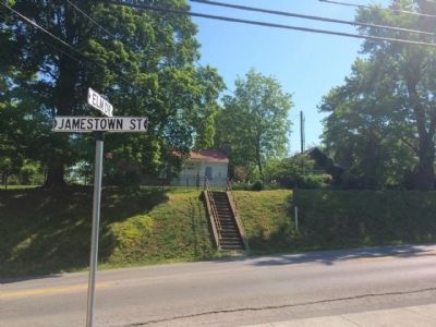
Preston H. Leslie, born Ky., 1819. Died Montana, 1907. Completed term of Gov. John Stevenson from Feb. to Sept., 1871, when elected 27th Governor of Kentucky. Known for his sound judgment of State affairs and meeting the needs of growing population . . . — — Map (db m87981) HM
On U.S. 31 E at Lexington Drive, on the right when traveling south on U.S. 31 E.
Henry Skaggs and two companions trapping beaver, winter 1770-71, were probably first white men in this area. Named Long Hunters due to long period away from home in the East. Came through Cumberland Gap, 1769, in party led by James Knox. Skaggs’ . . . — — Map (db m87978) HM
On Finney Road (Kentucky Route 252) 0.1 miles Old Kentucky Road 252, on the left when traveling east.
Prized by frontiersmen, now rare collectors' items; they were made by three Settle generations in Barren County. Starting in 1800, William made flintlocks at Rocky Hill. A son, Felix, had shops in Glasgow, Roseville. Felix's sons, Simon and Willis, . . . — — Map (db m143078) HM
On Old Dixie Highway (State Highway 255) west of J. Brown Road, on the right when traveling east.
Erected by Wm. Bell, 1830. Stage stop for his lines that brought visitors to Mammoth Cave when first promoted. Famed in U.S. and Europe for elite patrons, cuisine and magic peach and honey brandy for “Joy before the journey’s end”, until it burned . . . — — Map (db m96715) HM
Near Mammoth Cave Parkway (State Highway 255) 1.3 miles north of Interstate 65, on the right when traveling north.
A trip on the Mammoth Cave Railroad wasn’t comfortable, and it wasn’t posh. It was a means to an end, a destination most of its passengers anticipated with a mixture of excitement and foreboding — the caves.
They came by the . . . — — Map (db m96714) HM
Near Mammoth Cave Parkway (State Highway 255) 1.3 miles north of Interstate 65, on the right when traveling north.
On July 14, 1859, a slave was lowered into a pit discovered on the farm of Jesse Coats. He saw glistening calcite crystals that he thought were diamonds. The first public tour was made by a wedding party on August 19, 1859. Guidebooks were written . . . — — Map (db m96712) HM
On U.S. 60 at Old River Road, on the left when traveling west on U.S. 60.
Caney Furnace
Stood five miles south. This stone stack, built 1837-38 by Harrison Connor and Joshua Ewing, Sr., was among first iron furnaces west of the Alleghenies to be equipped with a hot-blast oven, a device to preheat the air blown . . . — — Map (db m110123) HM
Formed from Montgomery County, 1811. Named for its many mineral springs. The birthplace of CSA Gen. John B. Hood and US Senator Richard H. Menefee. Owingsville named for Col. Thomas D. Owings. Organizer US 28th Inf. Reg., 1812. Associate in . . . — — Map (db m26286) HM
On Kentucky Route 36, on the left when traveling north.
Bourbon Iron Works Jacob Myers from Richmond, Va. took up land grants here on Slate Creek, 1782. He built the first iron blast furnace in Ky., 1791. John Cockey Owings and Co. formed to operate furnace. Utensils and tools supplied settlers. . . . — — Map (db m110121) HM
On West Main Street, on the left when traveling west.
Owings House
Built 1811-14 for Colonel Thomas Dye Owings by Benjamin Latrobe, who redesigned the interior of the US Capitol after the British burned it, War of 1812. This house was a center of social life during early 1800's. Henry Clay, . . . — — Map (db m110150) HM
On Main Street (Kentucky Route 211), on the right when traveling north.
Clear Creek Furnace
Built in 1839, 5 miles south, by W. A. Lane and W. S. Allen. Stone stack originally 40 ft. high and 10 1/2 ft. across inside, burning charcoal. Air blast powered by steam. Its iron was used mainly for railway car wheels. . . . — — Map (db m110122) HM
Alexander Arthur, 1846-1912, an outstanding figure in history of Middlesboro. He came here in 1885 to prospect, discovering coal and iron ore deposits. President of American Association, formed to carry out his plans for a mining and manufacturing . . . — — Map (db m33298) HM
The impressive turreted building of the New South Brewery and Ice Company once stood in front of you. Manager William Wallbrecht and brewmaster Mr. Kumli employed dozens of area men to brew beer here. Their leading brands included Pinnacle, Crystal . . . — — Map (db m207778) HM
On Pinnacle Road, on the right when traveling east.
Two hundred years ago, pioneers poured through Cumberland Gap on their way west to a better life. But not all the traffic on the Wilderness Road was westbound. By the 1820s, drovers pushed huge herds of hogs and smaller herds of cattle and sheep . . . — — Map (db m167001) HM
On 12th Street (U.S. 25E) at 14th Street East, on the right when traveling south on 12th Street.
Watts Furnace
Stood ½ mile SW. A pair of blast furnaces built by the Watts Steel and Iron Syndicate, Ltd., 1890-93, and operated until 1898. Each iron shell stack was 75 ft. high with a maximum inner diameter of 17 ft. Using coke fuel and . . . — — Map (db m170830) HM
On Bob Madon Bypass (U.S. 25E) at Tennessee Avenue, on the right when traveling west on Bob Madon Bypass.
The first to begin operations in Bell County, starting in 1889, with 1500 acres of coal land. Extension of the Louisville and Nashville Railroad to this area in 1888 marked the beginning of a new industrial era. This mine was not a financial . . . — — Map (db m35854) HM
Near Washington Street (Kentucky Route 18) near Jefferson Street, on the right.
From its earliest days, Burlington was the hub of a community rooted in farming. Prior to World War II, the majority of people in Boone County lived and worked on farms and the livelihood of nearly everyone else was somehow connected to farming. By . . . — — Map (db m134233) HM
On North Jefferson Street (Kentucky Route 338) west of Temperate Street, on the right when traveling west.
One of several log structures on North Jefferson Street, this c. 1860 single pen log house was once part of the Willis Graves estate. It is named after James Hogan, who owned it from 1881 to 1912. The house was rehabilitated as a craft shop in 1992. . . . — — Map (db m201101) HM
On Union Square north of Washington Street (Kentucky Route 18), on the right when traveling west.
Built for Elijah Kirtley c.1830, probably by Benjamin Piatt Fowler, this substantial brick I-House served as the Boone House Tavern until 1870. It later became the residence of Fountain Riddell, attorney, state legislator and founder of the Boone . . . — — Map (db m186256) HM
On Washington Street (Kentucky Route 18) at Garrard Street, on the right when traveling west on Washington Street.
Built c. 1887 by Senator Samuel Walker Tolin (1849-1933), this brick residence retains the finest Folk Victorian detailing in Burlington. Tolin was a well-known attorney and Kentucky State Senator in 1902 who practiced law out of this building for . . . — — Map (db m201103) HM
On Main Street at Dixie Highway (U.S. 42), on the right when traveling east on Main Street.
John Uri Lloyd (1849-1936). Born in NY, came to Boone Co. KY in 1853. Pharmacist, chemist, inventor & electric herbal medicine pioneer. Wrote series of novels based on local folklore including Stringtown on the Pike in 1900. Founded . . . — — Map (db m201104) HM
On Kentucky Route 8, on the left when traveling east.
1937 Flood at Constance
The Ohio River reached its peak
on Jan. 26 at 79.9 ft. surpassing
the 1884 record. Constance was the
hardest hit town in Boone Co. but
there were no fatalities. Route 8
between Constance & Taylorsport
was almost . . . — — Map (db m133629) HM
On Front Street west of Tanner Avenue, on the right when traveling south.
Lewis Loder (1819-1905). Born in Pennsylvania, he moved to Petersburg in 1858 and lived in a c. 1840 house at Tanner & Front Sts. He served as justice of the peace and operated a tavern in his home for many years. Loder was hired as clerk & . . . — — Map (db m133205) HM
On Ryle Road at Boat Dock Road (Kentucky Route 1925), on the right when traveling south on Ryle Road.
Discovered in 1739 by French Capt. Charles Lemoyne de Longueil. Early explorers found countless bones and teeth of extinct Pleistocene elephants, the mammoth and the mastodon. This saline-sulphur spring was popular for salt making until 1812: also a . . . — — Map (db m175117) HM
On Main Street (Business U.S. 68) at 9th Street, on the right when traveling north on Main Street.
Alexander House
The federal style house was built for William W. Alexander, a state representative 1848-52. His father, William Alexander, owned a hemp factory until 1856, which was operated by 100 enslaved people. At 600 feet, it had one of . . . — — Map (db m170055) HM
On U.S. 27 at Kentucky Highway 1876, on the right when traveling south on U.S. 27.
Bourbon Whiskey
Named after Bourbon Co. because of quantity and quality of whiskey produced within its borders. Made from a fermented mash of at least 51% corn, with less wheat, rye, or barley, yeast and limestone water. Distilled at no more . . . — — Map (db m35597) HM
On High Street (U.S. 460), on the right when traveling south.
This log building lined with adz-hewn cherry was built as a tavern. In 1795 it became first post office in Paris. Thomas Eades then served as tavern owner and postmaster. Robert Trimble had home and law office here before becoming U.S. Supreme Court . . . — — Map (db m43626) HM
On Winchester Street (Kentucky Route 627) at Vine Street, on the right when traveling south on Winchester Street.
Sites of birthplace of Garrett A. Morgan, and Branch School, which he attended, are ¼ mile south. He invented the tri-color traffic signal, forerunner of the present type, and a gas mask worn in rescue work at Cleveland, Ohio, 1916. His mask was the . . . — — Map (db m170056) HM
On Russell Cave Road (Kentucky Route 353) 0.3 miles south of Centerville Lane, on the right when traveling south.
Frankfort & Cincinnati Railroad
Built 1888-90 as the Kentucky Midland Railroad, it spanned 40 miles from Frankfort to Paris. Had connections on both ends to the L&N. Name changed to Frankfort & Cincinnati in 1899, but it had no connections . . . — — Map (db m170050) HM
On Ruddells Mill Road (Kentucky Route 1940) at Old Ruddles Mill Road (Kentucky Route 1893), on the right when traveling south on Ruddells Mill Road.
Near his home Isaac Ruddell built a gristmill in 1788 on the north side of Hinkson bridge, and a sawmill in 1795 to be operated by his son, Abram. A 720-spindle cotton mill erected 500 feet west by Thomas and Hugh Brent in 1828, burned 1836. Soon . . . — — Map (db m171782) HM
On 15th Street at Front Street, on the right when traveling north on 15th Street.
During World War II American women contribute to the effort by working side by side with men in the defense industry. Ashland Clayton & Lambert plant was no exception. There, local women helped produce millions of 40 mm shell casings for the U.S. . . . — — Map (db m228071) HM
On Winchester Avenue at 15th Street, on the left when traveling west on Winchester Avenue.
Ashland, the largest city in eastern Kentucky, is located on the banks of the Ohio River in Boyd County. This second class city, when first incorporated by act of legislature in 1856, was located in Greenup County. Boyd County was created four years . . . — — Map (db m228063) HM
On Winchester Avenue (Business U.S. 23) at 23rd Street, on the left when traveling east on Winchester Avenue.
NORTON FURNACE. In 1967, the world’s oldest known operating blast furnace. Built by Norton Iron Works Co. in 1873, an iron shell stack 67 ft. high with maximum inner diameter of 18 feet, burning “stone coal.” It produced 10,502 tons . . . — — Map (db m128281) HM
On Bellefonte-Princess Road (Kentucky Route 5) at Princess Drive and Oxcart Road, on the left when traveling south on Bellefonte-Princess Road.
Bellefonte Furnace. The most successful of pioneer
Kentucky charcoal furnaces in the
Hanging Rock Iron Region. Built
by Archibald Paull, George Poague
and others in 1826. Its stone
stack was 34 feet high with a
maximum inner diameter of . . . — — Map (db m126468) HM
On Kentucky Route 5 at Straight Creek Road, on the left when traveling north on State Route 5.
Buena Vista Furnace Built by William Foster and Co. in 1847, 2¼ miles west, named for Mexican War battle that year. It was an important factor in the Hanging Rock iron industry until dismantled in 1876. Its 1874 production was 4113 tons. Stone . . . — — Map (db m126266) HM
On Kentucky Route 5 at Princess Drive, on the left on State Route 5.
Princess Furnace. Built here in 1876-77 by Thomas W. Means (1803-90), for 50 years the leading figure in the iron industry of this area, owner of furnaces in Kentucky, Ohio, Virginia, Alabama. This iron-jacketed stack burned “stone . . . — — Map (db m126230) HM
On U.S. 60 south of Shopes Creek Road (Route 583).
Clinton Furnace. Stood one mile east. Its stone stack was 10 ft across inside, about 35 ft. high, built in 1832 by George, William Thomas H. and Hugh A. Poage. In 270 days of 1838 it used 2992 tons of ore, 247,000 bushels of charcoal to make . . . — — Map (db m126229) HM
On Kentucky Route 3 just south of Bolts Fork Road (Kentucky Route 773), on the left when traveling south.
Sandy Furnace. Built 1853 by Young, Foster & Co
(Dan and John Young, William Foster,
Irwin Gilruth), 4 miles west on a
9,000 acre tract. Stone stack
originally 32 ft. high, 10½ ft.
across inside. In 1854, its last
year of operation, . . . — — Map (db m126132) HM
Grayson’s Tavern, circa 1785, was owned and operated by Benjamin Grayson as the first tavern in Danville. The political club of Danville, formed in 1786, met here frequently to discuss issues which formed the framework of the Kentucky Constitution. — — Map (db m121730) HM
Born in Boyle Co. and a graduate of Centre College, 1850, Harlan practiced law in central Ky. after 1853. Although against Lincoln and abolition in 1860, he was a strong Unionist during Civil War; recruited 10th Ky. Infantry. Elected Attorney . . . — — Map (db m121559) HM
On South Buell Street (U.S. 68) at West Second Street (U.S. 150), on the right when traveling south on South Buell Street.
(obverse)
Merchants' Row
Originally known as Main St., the town's historic commercial center renamed Buell St. to honor Union general D.C. Buell. Now called Merchants' Row, most buildings built 1830-40. Temperance leader Carrie . . . — — Map (db m46399) HM
On North Bragg Street, Harrodsburg Road (U.S. 68) north of Hardee Street, on the left when traveling south.
W. H. Rogers, president of Inter-County R.E.C.C., threw the switch at the Perryville substation on June 10, 1938, to energize 56 miles of line to 115 homes. In 2013, on the 75th anniversary of this event, Inter-County Energy served more than 25,000 . . . — — Map (db m68402) HM
On Augusta chatham Road (Kentucky Route 19) north of Mary Ingles Highway (Kentucky Route 8), on the left when traveling south.
During the 1870s, leading wine-producing county of US, furnishing over 30,000 gallons annually, half the entire national production. Germans, finding soil here similar to that in France and Spain, brought grape cultivation and wine production to . . . — — Map (db m136283) HM
On West Main Street (State Road 2200) at Oak Street, on the right when traveling west on West Main Street.
Cloverport, an important shipping point beginning in 1798 when Joe Houston came from Va.: built home and started trading and shipping business. Flatboats carried Ky. tobacco, other goods for sale in New Orleans. Boats sold as lumber. Men came back . . . — — Map (db m160276) HM
On West Main Street (Kentucky Route 2200) east of Center Street, on the right when traveling west.
Coal oil first produced here 1851. Plant built 1857, reputed first of kind in world. Mine known for extensive veins of cannel coal. Coal loaded here, exported to England via New Orleans for gas manufacture. English-owned with Prince of Wales (King . . . — — Map (db m119795) HM
On Preston Highway (Kentucky Route 61) at Beech Grove Road (County Route 1494), on the left when traveling north on Preston Highway.
Stood one mile west. It was a stone stack 33 ft. high with a maximum inner diameter of 10 ft. Its fuel was charcoal, and its air blast machinery was driven by a steam engine, blowing preheated air through the stack. Built in 1832, perhaps by John H. . . . — — Map (db m122030) HM
Welcome to the Baker Beam Home, named after Jim Beam's great-nephew, Baker, who lived & worked here as the Clermont plant distiller.
Built in 1911, the Beam family has called this house "home" since 1934 - the year Jim Beam's son T. Jeremiah . . . — — Map (db m237767) HM
On Happy Hollow Road, on the right when traveling west.
The legendary sixth generation master distiller, seen here with his faithful dog and pal, Dot.
Spent more than 50 years overseeing the production of his family's whiskies.
In 1988 Booker introduced his private stock small batch whiskey, . . . — — Map (db m237869) HM
On Jim Beam Way just north of Happy Hollow Road, on the right when traveling north.
James Beauregard "Jim" Beam was the fourth generation bourbon distiller and most recognized member of the dynastic Beam family. Utilizing the Beam signature mash bill and knowledge passed down through generations of Beams since they began distilling . . . — — Map (db m237873) HM
On Pioneer Drive, 1 mile south of East Pioneer Drive, on the left when traveling south.
Belmont Furnace
Stone stack 500 yds. east, 33 ft. high originally, 10 ft. across inside. Built in 1844, perhaps by John H. Baker, rebuilt in 1853, it burned charcoal fuel, smelted iron ore from Cane Run. The air blast machinery was powered . . . — — Map (db m174393) HM
On Kentucky 44 West at Raymond Road, on the right when traveling west on Kentucky 44 West.
Located by Captain Thomas Bullitt, 1773. Site of early commercial production of salt in Kentucky. This lick provided salt for Kentucky settlements and the Illinois country. — — Map (db m174439) HM
On Reedyville Road (State Road 185) 0.3 miles south of Lock 5 Road, on the left when traveling south.
William Stephens, Sr., gunsmith by trade, came to America from England with his two sons, 1832. They traveled overland, then down the Ohio to the Green River, where they bought 150 acres in 1854. The gunshop operated from 1855-61, when Stephens' two . . . — — Map (db m162250) HM
On North Harrison Street at West Main Street, on the left when traveling south on North Harrison Street.
Here on December 1, 1906, began Black Patch War, which lasted to the end of 1908. “Night Riders” fought against non-cooperative farmers and businessmen who opposed the dark tobacco pool. — — Map (db m79151) HM WM
On Kentucky Route 672 north of Cobb Spur Road, on the right when traveling north.
Dr. David Amoss, leader of Night Rider movement, was born in Cobb, Ky. on October 19, 1857. Moved by compassion for his people, this country doctor provided leadership for tobacco farmers in Ky. & Tenn. He led an organized society of dark tobacco . . . — — Map (db m166061) HM
On State Highway 121 at Cypress Trail, on the right when traveling north on State Highway 121.
Gerard Furnace Built 2¼ miles east in 1854 by Browder, Kentucky and Co. Inside it was 24ft. high and 10½ ft. across at widest point, burning locally made charcoal fuel. Its air blast machinery was powered by steam. In 34 weeks of 1857, it . . . — — Map (db m37941) HM
On Clayridge Road south of Smith-Hiteman Road, on the right when traveling south.
Many salt wells located in this area, left over from the last Ice Age. Salt making was an early business in Grant's Lick. John Grant was one of the owners, and the entire area is named for him. Mary (Boone) Bryan — sister to Col. Daniel Boone — is . . . — — Map (db m175100) HM
On Alexandria Pike (U.S. 27) at Kenton Station Road (Kentucky Route 1936), on the right when traveling south on Alexandria Pike.
Ca. 1793, salt water found here by
Samuel Bryan, a nephew of Daniel
Boone. John Grant, another Boone
nephew, and Charles Morgan helped
him drill well, which supplied salt
to interior of Ky. This territory
was owned by John Grant and named
for . . . — — Map (db m175099) HM
On East 6th Street west of Riviera Drive, on the left when traveling west.
Established in 1875, the Covert Run Turnpike covered two miles from Newport through Bellevue, to Ft. Thomas. By 1916, the turnpike was part of 62 miles of private road in
Campbell County.
The replica toll arm commemorates the turnpike toll house . . . — — Map (db m217791) HM
Brig. Gen. John T. Thompson, USA, inventor of Thompson submachine gun, was born here in 1860. A West Point graduate of 1882, he was early advocate of automatic weapons and improved many small arms. Awarded Distinguished Service Medal as Director of . . . — — Map (db m98032) HM
Near Riverboat Row, on the right when traveling north.
James Smith brewed an English style beer in Newport as early as 1798. In the 1840s and 1850s German immigrants introduced the new style lager. Although several breweries operated in Newport after the Civil War, the one established by George . . . — — Map (db m174788) HM
Near Riverboat Row, on the right when traveling south.
Cincinnati 1800
Twelve years after its founding, Cincinnati was still a rough village of mostly two-story log and frame houses with a population of 750. No real skyline yet existed — unless you count the steeple of First Presbyterian Church . . . — — Map (db m174863) HM
In 1792 James Taylor sent his two sons, James and Hubbard, to Kentucky to assess 2,500 acres of land awarded him for service in the Revolutionary War. In 1793 the younger James was sent again with instructions to develop and expand those holdings. . . . — — Map (db m174741) HM
On West 5th Street (Kentucky Route 8), in the median.
Built three blocks east in 1859 by Swift's Iron and Steel Works. As rebuilt in 1869, it was 65 feet high, with a maximum diameter inside of 16 feet. Its annual capacity was 17,000 tons of iron, using Connellsville coke as fuel. Iron mostly converted . . . — — Map (db m49114) HM
Near Riverboat Row, on the right when traveling north.
Before pioneer families settled Kentucky and Ohio, Native Americans followed the Licking River to the grasslands of central Kentucky to hunt abundant buffalo and deer. The early settlers probably named the river for the many salt licks nestled in . . . — — Map (db m174777) HM
Near Riverboat Row, on the right when traveling south.
Cincinnati 1910
Skyscrapers built along Fourth Street during the first decade of the 20th century transformed Cincinnati — and its skyline. Photo courtesy of the Cincinnati Historical Society
[Photograph] . . . — — Map (db m174879) HM
Near Riverboat Row, on the left when traveling south.
By the mid-19th Century Newport emerged as a center of Kentucky's thriving iron and steel industry. In 1850 the Licking Rolling Mill employed 120 workers and annually transformed over 3,000 tons of pig iron into finished product.
In 1891 Joseph . . . — — Map (db m174797) HM
For Col. William Grayson Carter, state senator, 1834-36. The 88th Ky. county formed, 32nd in size. Carter was created from Greenup and Lawrence. Noted in early years for 5 iron furnaces, its clay products, industry developed in late 1800's. Carter . . . — — Map (db m73789) HM WM
On Hitchens Road (Kentucky Route 1) south of East Main Street (U.S. 60), on the right when traveling south.
Six miles south, site of famous iron
furnace, erected, 1848, by R. M.
Biggs and others. Operated 37 years,
averaging 15 tons pig iron daily
which was hauled by ox teams to
Ohio River for shipment. Iron
produced here was used for rails,
plows, . . . — — Map (db m144955) HM
On Carol Malone Road (Kentucky Route 1) 1 mile north of Interstate 64, on the right when traveling south.
Pactolus Furnace Built in 1824 by Joseph McMurtry and David L. Ward, on the site of an earlier bloomer forge. Its stone stack used charcoal fuel, and its air blast machinery was powered from a dam, 5 1/2 ft. high, in Little Sandy River. Capacity . . . — — Map (db m73787) HM
On U.S. 60 just west of Clay Hollow Road, on the left when traveling west.
Built in 1848 by A. McCullough and Lampton Brothers. Its stone stack was 36 feet high. 11½ feet across inside at widest point, and burned “stone coal” rather than charcoal. It was served by its own railroad spur. In 1866 it produced . . . — — Map (db m144425) HM
Saltpeter mined here from which gunpowder was made that was used by Kentucky riflemen during the war of 1812. There are remains of those works in cave, reputed rendezvous for counterfeiters in early years, artifacts and Indian graves found in cavern. — — Map (db m164261) HM WM
On Local Road 8024A, 0.2 miles east of Cave Road, on the right when traveling north.
Saltpetre Cave is considered by many historians to be the site of the earliest industry in the area. The cave was used during the War of 1812 as a source of the major ingredient in making gunpowder. The site is currently listed on the National . . . — — Map (db m164394) HM
On State Road 70 at Bethel Ridge Road, on the right when traveling east on State Road 70.
A community and church leader, businessman and farmer, he opened first general store in 1876. Gave Bethelridge its name, 1890, and was the first postmaster. Sponsored first telephone. Helped establish banks at nearby Middleburg and Eubank. His . . . — — Map (db m244657) HM
On Lafayette Road (Kentucky Route 107) at Herndon Street, on the left when traveling north on Lafayette Road.
The dream of central-station electricity became a reality for 165 homes in the southern part of Christian County when a switch was thrown at this spot on the night of September 2nd, 1938. These 165 homes were the first members to be served by the . . . — — Map (db m123636) HM
On Cox Mill Road (State Highway 695) 0.3 miles south of Pierce Lane, on the right when traveling north.
Built 1878 by the Grange. Used ever since for public meetings. Kentucky's first farm cooperative, the Church Hill Grange operated a livestock market here. Leading this pioneer cooperative were two Christian County farmers, Winston J. Davie, first . . . — — Map (db m158702) HM
On South Virginia Street (U.S. 41) at East 7th Street, on the right when traveling north on South Virginia Street.
Erected on this site, 1894, and named for Hopkinsville native and philanthropist, John C. Latham, Jr. Structure was Italian Renaissance style. It became a well-known tourist stop, social and civic center. Among famous guests: Vice President Charles . . . — — Map (db m88902) HM
On Court Street at South Main Street (U.S. 41), on the right when traveling north on Court Street.
William Clark
William Clark, coleader of the Lewis & Clark Expedition, and his family stopped at Allsbury’s Tavern in Hopkinsville on Oct. 2, 1809. In 1807 Clark was appointed militia brigadier general and chief Indian agent for the . . . — — Map (db m88909) HM
On North Main Street near Roaring Springs Road, on the left when traveling east.
The Gas Station closed for good in 1994. After several owners, Steve Cherry restored the Station and used it as a hangout. He named it the Do Nothing Garage. — — Map (db m245677) HM
On South Main Street west of East Cross Street, on the right when traveling north.
The original building next door burned and was rebuilt at this location by the A. B. Lander family. It was the largest hardware store in Kentucky.
The only vacation Mr. Jimmy Lander ever took, was to a hardware convention in Northern Kentucky. . . . — — Map (db m245685) HM
On Athens Boonesboro Road (Kentucky Route 418) east of Jones Nursery Road, on the left when traveling east.
Jones Nursery
Griffin Fauntleroy Jones began one of Kentucky’s earliest commercial nurseries. He sold fruit and ornamental trees, shrubs, and vines. Many orchards in Clark and surrounding counties were supplied from Jones’ Nursery. . . . — — Map (db m169688) HM
On Lexington Road (U.S. 60) west of Clintonville Road, on the right when traveling west.
Clark County Hemp. One of the ten Bluegrass counties which produced over 90 percent of the entire country's yield in late 1800s. Production increased from 155 tons in 1869 to over 1,000 tons in 1889, valued at about $125 per ton. In 1942, . . . — — Map (db m170047) HM
On Bucknerville Road south of Colby Road (County Route 1927), on the left when traveling south.
Built in 1820s by Colby Taylor as a place of rest and entertainment on stage road from Winchester to Lexington. In 1832, President Andrew Jackson visited here on his trip to Winchester. During antebellum heyday in late 1840s, popular stop for those . . . — — Map (db m67745) HM
On Athens Boonesboro Road (Kentucky Route 418 at milepost 4.4), 0.1 miles east of Hidden Grove Lane, on the right when traveling west.
Colonel John Holder
John Holder commanded at Fort Boonesborough in 1779 and est. Holder's Station near the mouth of Lower Howard's Creek in 1782. He led a garrison at Vincennes in George Roger Clark's 1786 Wabash Campaign & was appointed a . . . — — Map (db m206154) HM
On North Main Street (U.S. 60) 0.1 miles north of East Broadway Street, on the right when traveling north.
Winchester, KY was established in 1793. The city underwent a boom with the arrival of railroads and became a major banking and commercial center. Winchester’s location as the "Gateway to the Mountains" of Eastern KY . . . — — Map (db m164253) HM
On Lexington Rd (U.S. 60) 0.9 miles east of Venable Road, on the right when traveling west.
On July 7, 1941, thirteen of Kentucky's rural electric co-ops formed East Kentucky Power Cooperative to relieve the electric power shortage common in rural areas. In 1951, Hugh L. Spurlock became EKPC's first general manager. Construction began . . . — — Map (db m167030) HM
On College Street west of Wheeler Avenue, on the left when traveling west.
Homer Ledford (1927-2006) was a master craftsman, musician, and teacher. Born in Tennessee, he came to Kentucky to attend Berea College & graduated from Eastern Ky. University. Ledford founded the Cabin Creek Band in 1976 & led it for 30 years, . . . — — Map (db m67751) HM
Near Railroad Avenue south of Poplar Street, on the right when traveling south.
Salt works established early 1790s; Clay County established here in 1807
The Goose Creek Salt Works dates from the mid 1790s when it was known as the “Langford Works” and was well known throughout Kentucky and in . . . — — Map (db m87858) HM
On Kentucky Route 70 at Axel Creek Road, on the left when traveling north on State Route 70.
Built a mile west by Gideon D. Cobb in 1847, 9 feet across inside, 30 feet high, charcoal-fueled, with steam-powered machinery. In 1855 made 1300 tons of iron. Named for newly formed county, it was last of several ironworks operated by the Cobb . . . — — Map (db m136457) HM
On North Walker Street north of East Bellville Street (Kentucky Route 120), on the left when traveling north.
F. Julius Fohs (1884-1965)
F. Julius Fohs was born in N.Y. but moved to Marion, Ky. in 1890. He graduated from Marion High School. Managed fluorspar mining operation, 1900-1904; served as assistant state geologist for Ky., 1905-12. . . . — — Map (db m123766) HM
On North Main Street (Kentucky Route 61) at Hill Street, on the left when traveling south on North Main Street.
Established 1798, taken out of Green County. Later, between 1800 and 1860, parts of Wayne, Monroe, Russell, Clinton, Metcalfe were taken from its original territory. First known white men here, 1769. Daniel Boone explored area, 1771. Burkesville, . . . — — Map (db m98889) HM
On Hill Street at North Main Street (Kentucky Route 61), on the right when traveling east on Hill Street.
It all began in 1814 when three brothers, John, Philip, and Reuben Alexander opened a store called the "J.P.R. Store." Throughout the 19th century this store, not only sold drugs for man and animal, but sold everything from planks to cuff buttons. . . . — — Map (db m98885) HM
On River Road (State Road 331), on the right when traveling north.
Robert Triplett built the first railway in Kentucky, 1826. Coal was moved from Bon Harbor hills to steamboats on the Ohio River. Triplett was first to get coal substituted for wood as fuel on river boats below Louisville. Coal was shipped south, . . . — — Map (db m160127) HM
501 entries matched your criteria. The first 100 are listed above. Next 100 ⊳