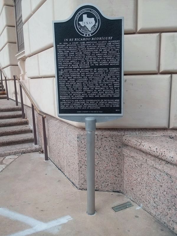
In 1896, a court case involving Ricardo Rodríguez brought attention to questions of citizenship and voting rights for Mexican Texans. Although several actions had granted citizenship to large numbers of Tejanos during the 1800s, some sought to . . . — — Map (db m130096) HM
These iron 4 pound cannon replicas are based on the measurements of the cannons recovered in 1852 by Samuel Maverick near the northwest corner of the Alamo. Archival research indicates that these cannons were on site but not in use during the Battle . . . — — Map (db m188609) HM
As the granddaughter of Lorenzo de Zavala (1789-1836), first vice-president of the Republic of Texas, young Adina de Zavala was exposed to vivid accounts of Texas' revolutionary and republican past. She became a guiding force in the preservation . . . — — Map (db m61083) HM
Mission San Antonio de Valero, established nearby in 1718, was relocated here in 1724. By 1762, the mission plaza was enclosed by thick stone and adobe walls. The 11x14-foot main gateway was located at this site along the south wall. In 1803 . . . — — Map (db m30713) HM
March 6, 1836 - - - - March 6, 1986
Commemorating the sesquicentennial of the Battle of
the Alamo by the Daughters of the Republic of Texas
"I shall never surrender or retreat. Then, I call on you in the name of liberty, of patriotism . . . — — Map (db m232293) WM
At this location an exciting discovery was made. Approximately two feet below the current surface archaeologist recently uncovered a circular stone platform - but what is it?
Alamo archaeologist Kristi Nichols explains, "It appears to be . . . — — Map (db m188522) HM
Once called "bobwire" by cowboys, barbed wire was a French invention first patented in the U.S., in 1867, but it did not gain favor with cattlemen until late 1870s. Joseph Glidden of Dekalb, Illinois, received a patent for his barbed wire in 1874, . . . — — Map (db m30607) HM
By 1835, tensions between those in Mexico who supported republican ideals and the centralist Mexican government had escalated into all-out war. Seeking their independence, Texan revolutionaries won the town of San Antonio de Béxar from . . . — — Map (db m188616) HM
Spanish soldiers saved this 18th-century cannon from a shipwreck in Matagorda Bay located off the Texas coast in 1817. It was brought to San Antonio where it was later captured by Texian forces during the Battle of Béxar (1835). The following year, . . . — — Map (db m188593) HM
Typical of the type of cannon purchased by merchants during the 18th century to guard ports and ships, this 4 pounder was cast in Great Britain sometime after 1725. It was used by the Texans during the 1836 Battle of the Alamo. Once Texas won its . . . — — Map (db m227651) HM
Characteristics of this light cast-iron cannon are similar to ones produced in Sweden for the commercial market in the 18th century. Any distinguishing maker marks have been lost. It likely came to Texas through trade, capture, or purchase. Found . . . — — Map (db m227658) HM
Characteristics of this light cast-iron cannon are similar to French patterns produced for the commercial market during the late 18th century. It likely came to Texas through trade, capture, or purchase. It was found in 1852 by workman digging in a . . . — — Map (db m227659) HM
Title to the Alamo Mission property,
acquired through her efforts and
her personal fortune, was conveyed by
Clara Driscoll
to the State of Texas, Sept. 5th 1905:
“That the sacred shrine be saved from the
encroachments of . . . — — Map (db m30734) HM
Whereas: The memory of Clara Driscoll will be immortal in the hearts of the Daughters of the Republic of Texas for the patriotic work which held her great interest, from her girlhood through her life.
Whereas: Clara Driscoll is known throughout . . . — — Map (db m232679) HM
(Born August 1, 1809) sacrificed his life for Texas liberty while defending the north wall of the Alamo in the vicinity of the present day federal building (across Houston) on March 6, 1836. — — Map (db m188587) HM
David Crockett was a frontiersman who became a well-known politician and humorist in early 19th Century America. In a period of history that celebrated the rise of the common man, no common man rose higher from such humble beginnings. "Davy" . . . — — Map (db m188527) HM
In 1836, an 18-pounder cannon similar to the one seen here was mounted to defend the Alamo's southwest corner. The 18-pounder played a legendary role in the prelude to the battle. After a brief parlay, the Alamo's commanding officer Lt. . . . — — Map (db m188611) HM
25 years ago, engineers tried to block rising damp by pushing a special plate made of corrosion-resistant alloy through the Alamo Church's foundations. Today's excavations here will tell preservation architects how well this metal plate, called a . . . — — Map (db m227628) HM
All great nations have creation myths, the Republic of Texas was no different. Born in New Haven, Connecticut, Emily D. West was a free woman of mixed race. In 1835, she signed a one-year contract in New York City agreeing to work as a housekeeper . . . — — Map (db m232623) HM WM
Robert H. H. Hugman, architect, revered for his role in development of the river walk, 1939-1941, opened his office at river level in this circular space in early 1941. He remarked at the time, "I opened my office at river level. When I did this, . . . — — Map (db m30606) HM
The San Antonio de Padua Mission was founded in San Antonio in 1716 by the Franciscan Father, Antonio Olivares, and after merging with the San Francisco Solano Mission in 1718, it was officially founded as the San Antonio de Valero Mission. The . . . — — Map (db m9228) HM
Mrs. Florence Terry Griswold (1875-1941), a native Texan reared along the Mexican border, provided aid to refugees of Mexico's 1910 revolution. On October 16, 1916, she and 21 friends met at the historic Menger Hotel to found the Pan American Round . . . — — Map (db m30596) HM
The Treaty of Velasco mandated that all Mexican forces withdraw south of the Rio Grande. Before leaving the Alamo, however, Mexican troops destroyed much of what remained. For many years, the structure stood deserted as the affairs of the new . . . — — Map (db m188747) HM
As the twentieth century approached, the historic Alamo Shrine was surrounded by commercial property, and original parts of the mission were in danger of being lost forever. Adina De Zavala, granddaughter of the first vice president of the Republic . . . — — Map (db m188760) HM
Erected in grateful recognition of
the supreme act of heroism of the
thirty two men from Gonzales
who gave their lives in the Alamo
in response to the appeal of Travis.
Erected March 1, 1936 — — Map (db m30777) HM
Hendrick Arnold, a free man of mixed race, emigrated from Mississippi in 1826, settling with his parents in Austin's Colony on the Brazos River. He played a key role in the Texas Revolution as a guide and spy for the Texian Army.
By 1835, . . . — — Map (db m232678) HM WM
This oak tree planted in the spring of 1965 in memory of the Heroes of the Alamo. Presented by the First Officers' Training Camp Association of Texas, Leon Springs, Texas, May 8...August 15, 1917. Roster of First Campers filed in Alamo Library. — — Map (db m30599) HM
Survivors Juana Navarro Perez Alsbury and son Alejo Perez, Jr. Bettie Dolores Cervantes Susanna Dickinson (Wife of Almeron Dickinson who died in the Alamo) and daughter Angelina Dickinson Ana Salazar Castro Esparza (Wife of Gregorio Esparza . . . — — Map (db m227737) WM
James Bowie represented the fluid nature of the frontier, born in Kentucky but living in Missouri and Louisiana before finally settling in Texas. Along the way, he gained a reputation as a deadly duelist with a knife.
Bowie traveled to Texas . . . — — Map (db m188534) HM
To the Memory of
The Heroes of the Alamo
[Poem in Chinese follows]
Japanese Monument
The story of the Alamo reaches far beyond the borders of Texas. More than 2.6 million visitors from around the world came to the Alamo in 1996. The . . . — — Map (db m30779) HM
Virginia-born John William Smith gained fame for the role he played in early Texas history. Smith, nicknamed "El Colorado" for his red hair, arrived in Texas in 1827 and settled in San Antonio de Béxar. He became fluent in Spanish, moving easily . . . — — Map (db m188529) HM
Born to a prominent San Antonio family, Juan Nepomuceno Seguín led a life of service to his community. He was both a solider and politician, becoming Mayor of San Antonio in 1841.
During the Texas Revolution, Seguín supported independence. He . . . — — Map (db m188526) HM
This cannon is characteristic of ones produced for the commercial market. The letter "B" on the trunnion indicates that this cannon was cast at the Bersham ironwork near Wrexham in north Wales, probably no later than 1800. Although this cannon was . . . — — Map (db m227647) HM
Commandancy of the Alamo -
Bexar, Feby. 24th, 1836 -
To the people of Texas & all Americans in the world --
Fellow citizens and compatriots
I am besieged, by a thousand or more of the Mexicans and Santa Anna - I have sustained a . . . — — Map (db m78329) HM
In the early 1900s, it was widely thought that mature trees could not be transplanted. Walter Whall, a retired English seaman, proved it could be done and started San Antonio's first tree moving company. With simple tools, he cleared dirt from . . . — — Map (db m188590) HM
Legend states that in 1836 Lt. Col. William Barret Travis unsheathed his sword and
drew a line on this ground before his battle-weary men stating: “Those prepared to
give their lives in Freedom’s cause, come over to me!” — — Map (db m123951) HM
Exact replica of pub in London's House of Lords. Theodore Roosevelt recruited "Rough Riders" here in 1898. Site of more cattle deals than any other place in Texas and San Antonio's oldest continuously operated saloon. — — Map (db m30556) HM
In recognition of its nurturing
atmosphere for
William Sidney Porter (O. Henry)
Theodore Roosevelt
Sidney Lanier
Oscar Wilde
January 14, 2000
———————
[Marker in the 1859 hotel lobby] . . . — — Map (db m31844) HM
William A. (1827-1871) and Mary Menger, both born in Germany, opened a boarding house and brewery at this site in 1855, when most local businesses were still clustered around Main Plaza and Military Plaza. The popularity of the boarding house led . . . — — Map (db m92750) HM
Early San Antonio boarding house keeper, Wm. Menger in 1859 opened fine stone hotel, the "new" Menger, beside Alamo Plaza. To host Indians, presidents, poets, actors, generals, singers, public of the world. Served venison, quail, mutton, beef, . . . — — Map (db m30597) HM
Mills were used to grind grain such as corn or wheat into meal or flour for use as food. The grain was poured into the hopper which funneled it through the eye in the top millstone. Water drove the waterwheel which turned the top millstone. The top . . . — — Map (db m30749) HM
First founded 1718 c 1 mile to west, moved to a new site c 600 ft. to south of present site in 1719, a 1724 tornado destroyed the mission. Moved to present site 1724, for 20 years it was a cluster of thatched houses of wood posts. A small pox . . . — — Map (db m164427) HM
Apache attacks caused a new stone wall to be built to enclose the Mission. A new unfinished stone church was started to replace the collapsed church of 1744.
Mission population: 149 Indians.
George Nelson Artist Phil Collins Sponsor
1. . . . — — Map (db m164428) HM
This wall foundation of adobe bricks formed part of the Indian quarters built during the construction of the west wall of Mission San Antonio de Valero (the Alamo) in about 1750. During the Siege of the Alamo, February 23 to March 6, 1836, some of . . . — — Map (db m164441) HM
"Blood of heroes hath stained me; let
the stones of the Alamo speak that
their immolation be not forgotten."
This tablet placed by the Daughters of
the Republic of Texas in commemoration
of the one hundredth anniversary of the fall of the . . . — — Map (db m164436) HM WM
During the days of prohibition, Pat O'Brien operated "Club Tipperary," one of the many speakeasies in New Orleans. When prohibition ended Mr. O'Brien moved his now legal establishment, Pat O'Brien's Bar, to its original location in the 800 block of . . . — — Map (db m243302) HM
"The river is one of nature's greatest gifts to San Antonio and should be appreciated and developed as such." Robert H.H. Hugman
Robert Hugman was the designer and architect of the original River Walk. In 1929, he proposed to transform the . . . — — Map (db m188658) HM
Beautification of the San Antonio River in the downtown area was a long-time dream of local residents. The river banks were landscaped beginning in 1904, only to be devastated by floods in 1913 and 1921. After a flood retention dam was completed . . . — — Map (db m227622) HM
This is the ruins of the habitations of the friars and Indians; refrectory, kitchen and other regular offices. In the second patio there was a gallery with weaving rooms and rooms for storing materials and utensils.
The habitations of the . . . — — Map (db m30742) HM
A native of South Carolina; came to San Antonio in 1835; was guide for Ben Mailam and other leaders in first attack on San Antonio by Texas Army, Dec. 1835. As Bexar Delegate, Maverick signed Texas declaration of Independence at . . . — — Map (db m30608) HM
San Antonio, Texas, has a rich, but complex history. Part of this history is the number of nations that held sovereignty over the area, beginning with Spain and ending with the United States. Stell's mural includes symbols-buildings and . . . — — Map (db m188657) HM
The exclusive Casino Club was organized in 1854 by San Antonio Germans. In 1881 the San Antonio Club was established for literary purposes. The institutions merged in 1925 to form San Antonio Casino Club. This building, completed in 1927 with its . . . — — Map (db m201828) HM
On this site are the springs used by the inhabitants of the ancient Indian village and later by Mission San Antonio de Valero and its adjoining pueblo. — — Map (db m30555) HM
On May 13, 1907, the San Antonio Section of the National Council of Jewish Women was organized in the Menger Hotel. Anna Hertzberg was elected president by the 15 charter members. The council immediately became active in the development of social . . . — — Map (db m30595) HM
During the Battle of the Alamo in 1836, the largest cannon of the Texan defenders was fired from a platform above this room. Originally built about 1750, in the last expansion period of Mission San Antonio de Valero, the room formed the . . . — — Map (db m164443) HM
When these buildings were built, Texas was part of the Spanish colony of New Spain. The buildings were part of the Mission San Antonio de Valero, established by Franciscan missionaries in order to convert the Native Americans living in the vicinity . . . — — Map (db m30774) HM
St. Joseph's Church was erected by the German speaking Catholics of San Antonio. The corner stone is dated May 8, 1866 and was laid on November 9, 1868. The church was dedicated by the Most Reverend C. M. Dubois in 1876. The first pastor of St. . . . — — Map (db m30604) HM
Conserving the Alamo Church means expert teamwork - and the excavation in front of you is a perfect example.
This unit is against the outside of the Alamo Church north wall. Guided by preservation experts, the archaeologists' goal is to expose . . . — — Map (db m188588) HM
A native of Tennessee, Susannah Dickinson and her husband, Almeron, settled in Gonzales, Texas in 1831. The couple had one daughter, Angelina, prior to the Texas Revolution. Living in San Antonio de Béxar in February 1836, the family took shelter in . . . — — Map (db m188533) HM
Theodore Roosevelt, Jr., American statesman, adventurer, and conservationist, is generally ranked as one of the five best Presidents of the United States.
With the beginning of the Spanish-American War in April 1898, Roosevelt resigned as . . . — — Map (db m232228) HM WM
In commemoration of the
150th Anniversary of Texas Independence
and in honor of the
Tennessee Volunteers
who gave their lives at the Alamo
on March 6, 1836
the Citizens of Tennessee
present this Tennessee Homecoming Tree and Plaque . . . — — Map (db m30775) HM
This is the Long Barrack, the oldest building in San Antonio. It was built in 1724 as a convento or residence for priests and was originally part of the Mission San Antonio de Valero, now known as the Alamo. Since then it has been used as a . . . — — Map (db m30743) HM
The Alamo
Mission San Antonio de Valero - famed as The Alamo - founded 1718 by Spanish Missionaries. Secularized 1793. Garrison for Spanish Cavalry and Flying Company of San Carlos de Parras y Alamo. Between February 23 and March 6, 1836, . . . — — Map (db m156704) HM
In Oct. 1835, 4 local Mexican troopers of the Parras de Alamo Co. were sent to Gonzales to retrieve a loaned cannon. They were seized and killed, then c 90 of the Alamo Co. were sent to retrieve the cannon and were fired on. This started the Texas . . . — — Map (db m164431) HM
Alamo City Subdivision
Samuel Maverick was a S. Carolina land speculator who had arrived in San Antonio in 1835 just at the start of the revolution. Sent as a delegate to form a new government, he barely missed being in the Battle of the . . . — — Map (db m164434) HM
In memory of the heroes who sacrificed
their lives at the Alamo, March 6, 1836,
in the defense of Texas.
“They chose never to surrender nor retreat.
These brave hearts, with flag still
proudly waving, perished in the flames
of . . . — — Map (db m30709) HM
Corrals for cattle and horses occupied this space during the famous 1836 Siege and Battle of the Alamo. Small fortifications provided cover for the Texans during the siege. The structures shown in the illustration are (left to right) the church, the . . . — — Map (db m30714) HM
The church of former Mission San Antonio de Valero had been converted into a powder magazine and artillery platform by the Mexican Army in the autumn of 1835 during the Siege of Béxar. Following the capture of the town in early December 1835, Texan . . . — — Map (db m30736) HM
The fortress known to history as “The Alamo” was originally built by the Spanish in the 18th Century. Named Mission San Antonio de Valero by Franciscan officials, the mission occupied this site from 1724 until it was closed in 1793. The mission . . . — — Map (db m30824) HM
One of the weakest points of the fortified former mission was an open space between the old church and the Low Barrack. During the Siege of Béxar, Mexican troops constructed a palisade, or double log-wall, to close the exposed area. The Texans . . . — — Map (db m30857) HM
Entry to former Mission San Antonio de Valero - better known
as the Alamo - was made through an arched gateway located in the middle of a single-storied structure called the Low Barrack. The Texans mounted cannon around the perimeter of the . . . — — Map (db m164438) HM
1836 found the Texians struggling to organize a provisional government as a confident Santa Anna marched into San Antonio de Béxar and demanded that the Alamo garrison surrender. On March 6, Mexican troops attacked the Alamo, stormed its walls, and . . . — — Map (db m188690) HM
This plaque was dedicated January 15, 1948, by Alamo Lodge No. 44 A.F.&A.M. commemorating the one hundredth anniversary of the chartering of the lodge and honoring those pioneer masons of that era, who founded the lodge upon this site. — — Map (db m30781) HM
With secularization, the religious emphasis of the mission was removed. The buildings were neglected until 1801, when a Spanish military unit from the Mexican province of Coahuila was sent to strengthen forces in San Antonio. The old mission was . . . — — Map (db m188673) HM
The Alamo in 1836 consisted of this church, the convent and a large rectangular area or plaza, an enclosure of about six acres surrounded by walls with barracks on the west side of the plaza. On February 23, 1836 Colonel William Barret Travis . . . — — Map (db m232312) HM
This region was inhabited by native peoples from early times. Among them were the Payayas, who lived along a river they called Yanaguana. On June 13, 1691, Franciscan Father Damián Massanet arrived and christened the river San Antonio de Padua in . . . — — Map (db m31015) HM
The wooden palisade was constructed by the Mexican Army in 1835, connecting the southwest corner of the Church and the eastern corner of the Low Barrack. This was an important fortification added to the Alamo in an area that was not protected . . . — — Map (db m227688) HM
Upon the death of his father in 1821, Stephen F. Austin brought American settlers to Texas. Mexico first encouraged immigration for colonists willing to become citizens under the Mexican Constitution of 1824. This democratic document gave power to . . . — — Map (db m188684) HM
This noble cottonwood grew on the bank of an acequia dug by the Franciscan Fathers. That ancient, historic canal flowed on the East side of the Alamo (Mission San Antonio de Velero) and through this patio. — — Map (db m30598) HM
This major thoroughfare contains many examples of San Antonio's spectacular commercial architecture of the late 19th and early 20th centuries. Houston Street began as El Paseo or Paseo Hondo, an unpaved lane lined with small private . . . — — Map (db m225224) HM
William Barret Travis accomplished much before his death at the Alamo in 1836. A native of South Carolina, Travis was raised in Alabama where he taught school, edited a newspaper, and passed the bar all before turning 21. He moved to Texas in 1831 . . . — — Map (db m188530) HM
San Antonio's population tripled to 161,000 between 1900 and 1920. Commercial and residential development boomed, and automobiles and streetcars clogged narrow thoroughfares. Local leaders recognized the need to modernize the outdated infrastructure . . . — — Map (db m119597) HM
The San Antonio River begins four miles north of here, fed by springs that rise from the Edwards Aquifer deep below the Texas Hill Country. The river is also fed by tributaries along its winding, southeasterly course to join the Guadalupe River . . . — — Map (db m125627) HM
Area was first explored and named by Spaniards in 1691. Colonial settlement began here May 1-5, 1718, with founding of Franciscan Mission San Antonio de Valero (later known as "The Alamo"). In vicinity of the mission was the Presidio San Antonio . . . — — Map (db m30588) HM
Today's bridges and street names contain hidden annals of San Antonio's deep history.
The Streets and Bridges that span San Pedro Creek define the modern city. But they also echo the legacies of the early settler families of New Spain . . . — — Map (db m225341) HM
At the Dedication of the Gettysburg National Cemetery November 19, 1863.
Four score and seven years ago our fathers brought forth on this continent a new nation, conceived in liberty and dedicated to the proposition that all men are created . . . — — Map (db m227459) HM
On this spot bodies of heroes slain at the Alamo were burned on a funeral pyre. Fragments of the bodies were afterward buried here. This tablet is the gift of relatives of Green B. Jemision and of other friends.
Second Marker
The De . . . — — Map (db m30589) HM
Anna Barbara (Heiman) (1828-1913) and Johann Engelbert (1821-1915) Heidgen (also Heitgen) came from Prussia to San Antonio in 1852. They bought property at this site, which at the time was on the eastern edge of the Irish Flats neighborhood.
. . . — — Map (db m235106) HM
The narrow strip of land known to residents in the middle 1800s as Galveston Island was actually a peninsula surrounded on three sides by a bend in the San Antonio River. It was called an island because the fourth side was almost completely closed . . . — — Map (db m128527) HM
This tract of land is a natural peninsula in the San Antonio River. It once was bounded by the river on three sides and on the fourth by the Concepcion Acequia. In 1845 John Bowen, a native of Philadelphia, bought the property from Maria Josefa . . . — — Map (db m30864) HM
Evangelist David Pennington came to San Antonio in 1883 and organized this Christian (Disciples of Christ) congregation. He held worship services in a variety of borrowed facilities until a sanctuary was constructed at this site in 1884. Central . . . — — Map (db m179572) HM
Born in Illinois, Charles Goodnight was brought to Milam County, Texas, as a child. He grew up on the frontier, becoming a ranger and Indian scout. During the Civil War, he served as a scout and guide in a frontier regiment. In 1865 Goodnight and . . . — — Map (db m227465) HM
Life in San Antonio in the 1700s revolved around Main and Military plazas west of the river and Mission San Antonio de Valero (the Alamo) east of the river.
Residents traveled between the plazas and mission along an unpaved street that led to a . . . — — Map (db m119155) HM
The main ford between San Fernando de Bexar (the city) and San Antonio de Valero (the Alamo), this river crossing has long been a focal point of history. At its footbridge on Feb 23, 1836, Alamo emissary Albert Martin met to parley with Santa Anna's . . . — — Map (db m30591) HM
These ancient waters also served as a resource for San Antonio's first entrepreneurs and aspiring industrialists.
San Pedro Creek was an invaluable source of water for residents who lived and farmed and grazed their livestock along its . . . — — Map (db m225336) HM
286 entries matched your criteria. The first 100 are listed above. Next 100 ⊳