Near Gloucester Court 0.4 miles west of Lower Woodville Road when traveling west.
[Top plaque]
Presented to
the Pilgrimage Garden Club
Natchez Mississippi
by the Kelly E. McAdams Foundation
Austin, Texas
1970
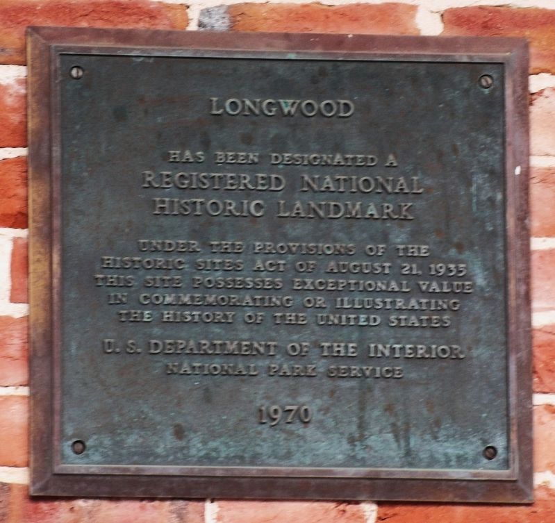
[Bottom plaque] Longwood has been designated a Registered National Historic Landmark under . . . — — Map (db m243661) HM
On St. Catherine Street at 6th Street, on the left when traveling west on St. Catherine Street.
The photograph of the 1946 Brumfield High School Choral. Club, taken in the front yard of Brumfield, provides the best image of the Louis Winston House on the left. The house unfortunately burned in the 1990s. The house on the right, which still . . . — — Map (db m114661) HM
On John R. Junkin Drive (U.S. 84) 0.6 miles east of South Canal Street, on the right when traveling east.
Explored, 1540-1, by De Soto. Colonized first by French, 1699. Became a colony of British, 1763; Spanish, 1779. Territory organized by U.S., 1798. Became 20th. state, 1817. — — Map (db m103799) HM
Near John A Quitman Boulevard west of Melrose Avenue, on the left when traveling west.
Natchez postmaster John Hankinson built Monmouth on two adjacent, 15-acre tracts, in 1818. He named his estate after his place of origin in Monmouth County, New Jersey. Monmouth was sold in 1826, to John A. Quitman. Quitman, born in New York, lived . . . — — Map (db m243751) HM
On Liberty Road at Stanley Davis Road, on the right when traveling west on Liberty Road.
The original church was located on Montgomery Plantation when it burned down during the civil rights movement of 1963. It was rebuilt at this site in 1964. — — Map (db m136946) HM
On St. Catherine Street east of McCabe Street, on the left when traveling west.
Alexander Lightfoot "Papa George" Papa George Lightfoot [1924-1971], he lived down the street from the alley I came up in, down on St. Catherine Street....He was a hustler, he had a snowball wagon, he sold peanuts. He would blow his harp . . . — — Map (db m108160) HM
On S. Broadway St at Bontura Street, on the right when traveling south on S. Broadway St.
First settled by French, 1716-29. Lasting growth came with Britain, 1763-1779, and Spain, 1779-98. Cotton and trade made it commercial and cultural capital of Old South. — — Map (db m4479) HM
Near S. Canal Street 0.2 miles north of John R. Judkin Drive (U.S. 84), on the left when traveling north.
Here passed, in 1543, De Soto’s men under Moscoso. In 1682 La Salle and De Tonti here visited the Natchez Indians. In 1716 Bienville here built Fort Rosalie and established a French settlement. In 1763 the fort was ceded to the English and renamed . . . — — Map (db m87167) HM
Near North Broadway Street near Jefferson Street, on the left when traveling north.
The Harper family mansion had a spectacular view of the river from the bluff. The construction of the railroad and related development made its land valuable for commerce, and the house and its garden were destroyed to build a large warehouse (no . . . — — Map (db m104673) HM
On March 12, 1816, a group of prominent women in the Natchez area formed the "Female Charitable Society.” Their goal was to house, educate, and care for children who had been orphaned within the Mississippi Territory. The Society established and . . . — — Map (db m214750) HM
Established in 1822 on a ten acre tract, this cemetery grew into a park notable for its variety of 19th century iron and marble work. People of all walks of life are buried within the cemetery. — — Map (db m50659) HM
On Jefferson Street at North Canal Street, on the right when traveling west on Jefferson Street.
Civil Rights Heroines Jessie Bernard Williams 1943-2018 1965 NAACP secretary and leader in the movement; a member of Democratic National Committee of Women; and educator in Natchez public schools. Mary Lee Davis Toles . . . — — Map (db m286374) HM
On Jefferson Street at North Canal Street, on the right when traveling west on Jefferson Street.
Civil Rights Act The March on Washington for Jobs and Freedom was the catalyst for the 1964 Civil Rights Act and the 1965 Voting Rights Act. The march, coupled with Dr. Martin Luther King Jr.'s “I Have a Dream” speech, were pivotal . . . — — Map (db m286372) HM
On St. Catherine Street near Old D'Evereux Street, on the left when traveling west.
The Deacons for Defense and Justice armed themselves in self-defense as a response to the attempted murder of local NAACP president George Metcalfe, whose car was bombed by the Ku Klux Klan in 1965. The first meeting of the Natchez Deacons was . . . — — Map (db m116326) HM
On St. Catherine Street 0.1 miles west of McCabe Street, on the left when traveling west.
The National Guard patrolled St. Catherine Street on September 3, 1965, not long after the August 27 bombing that nearly killed George Metcalfe, president of the local chapter of the Natchez Association for the Advancement of Colored People . . . — — Map (db m115639) HM
On Jefferson Street at North Canal Street, on the right when traveling west on Jefferson Street.
The National Guard patrolled St. Catherine Street on September 3, not long after the August 27 bombing that nearly killed NAACP President George Metcalfe. The crowd stands in front of the Dr. John Banks House (above), then headquarters of the . . . — — Map (db m286373) HM
On Saint Catherine Street near Abbott Street, on the right when traveling west.
This house played a pivotal role in the civil
rights movement, serving as headquarters for
the local NAACP and the home of its president.
George Metcalfe. During Freedom Summer of 1964,
when civil rights workers converged on the state.
members . . . — — Map (db m226608) HM
Near Cemetery Road 0.3 miles north of Maple Street, on the right when traveling north.
Civil War Natchez In 1860, Natchez was one of the wealthiest cities in the United States. Within the surrounding Adams County, population 19,000, nearly 70 percent were enslaved. A few individuals held the vast majority of those slaves. . . . — — Map (db m143536) HM
Near South Canal Street at John R. Junkin Drive (U.S. 84/425), on the right when traveling south.
William Johnson House 210 State Street The William Johnson House site consists of the Johnson home and kitchen, and the adjoining McCallum House. William Johnson, born a slave in 1809, was freed at age eleven and later became a . . . — — Map (db m137168) HM
On Silver Street 0.5 miles south of South Broadway Street, on the right when traveling south.
On May 8, 1840, one of the deadliest tornadoes in American history struck Natchez and killed about 300 people. Most of the dead were boatmen and passengers on steamboats docked at the waterfront. The city was already suffering from the economic . . . — — Map (db m143132) HM
On Silver Street 0.5 miles south of South Broadway Street, on the right when traveling south.
For most of the 1800s, the prime mover of commerce and passengers on the Mississippi River was the steamboat, which was invented by Robert Fulton in 1807. The combination of the steamboat, the cotton gin, and improved strains of cotton . . . — — Map (db m143122) HM
Near Jeff Davis Boulevard near South Temple Road, on the right when traveling north.
In 1972, archaeologists found evidence of several Natchez Indian houses in this area. In some cases, house floors were superimposed on one another indicating repeated use of these locations. The excavations revealed two different types of houses . . . — — Map (db m114671) HM
On Lissie Street 0.2 miles north of Liberty Road, on the right when traveling north.
After the American Revolution, frontiersmen from the Ohio Valley carried their products down stream to Spanish controlled New Orleans and Natchez.
Returning home, boatmen followed a series of Indian trails from Natchez to Nashville—trails . . . — — Map (db m87224) HM
Near McCabe Street south of St. Catherine Street, on the right when traveling south.
Side 1The rich legacy of blues, jazz, and gospel in Natchez has often been obscured by the tragic shadow of the notorious Rhythm Club fire that claimed some 200 lives here in 1940. Alexander “Papa George” Lightfoot was one of the most talented . . . — — Map (db m105233) HM
On South Union Street near Ravenna Lane, on the left when traveling west.
An outstanding example of Colonial Revival architecture, Ravennaside, built 1902, was the home of Roane Fleming Byrnes (1890-1970) and headquarters for her efforts in the creation and development of the Natchez Trace Parkway, the 444-mile National . . . — — Map (db m103821) HM
This tablet was erected in memory of those who lost their lives in the Rhythm Club Fire April 23, 1940
Inez Adams•
St. Elmo Adams•
Marjorie Alexander•
Susie Alexander•
Juanita Avery•
Bessie Lee Mont. Banks•
Joe Barnes•
Walter J. . . . — — Map (db m226719) HM
On Saint Catherine Street west of Abbott Street, on the right when traveling west.
On April 23, 1940, 209 African Americans died in a fire at the Rhythm Club, located at this site. An overflow crowd, which included civic and cultural leaders, had come to hear the Walter Barnes Orchestra of Chicago. Considered among America's most . . . — — Map (db m103794) HM
On S. Broadway Street, on the right when traveling south.
Noted African-American author of Native Son and Black Boy was born in 1908 near Natchez, where he spent his early childhood. His lifelong quest for freedom led him to Paris, France, where he died in 1960. — — Map (db m10059) HM
On East Woodlawn Street at Garden Street, on the left when traveling north on East Woodlawn Street.
Childhood home of noted American author Richard Wright, while he lived with grandparents Richard and Margaret Wilson in the Woodlawn neighborhood. Author of "Native Son" and "Black Boy", Wright was born outside Natchez in rural Adams County in 1908. . . . — — Map (db m170486) HM
On South Commerce Street south of State Street, on the left when traveling south.
Richard Nathaniel Wright was born in Roxie, near Natchez, in 1908.
In his youth, he suffered poverty, racism, and being shuffled between
an orphanage and the homes of relatives. In Jackson, he was
valedictorian of his class at Smith Robertson . . . — — Map (db m193094) HM
On Main Street at North Wall Street, on the right when traveling west on Main Street.
The Richard Wright Exhibit Hall Natchez Association for the Preservation of African-American Culture Museum This site is dedicated a Literary Landmark by Friends of Libraries U.S.A. October 23, 2008 Friends of the Judge George W. . . . — — Map (db m288896) HM
Near Jeff Davis Boulevard south of South Temple Road, on the right when traveling east.
In the early 1700s, a road began here and connected the Grand Village with the French colonial settlement on the Mississippi River bluff near what is now downtown Natchez.In 1723, French mapmaker Ignace Broutin produced a remarkably detailed map of . . . — — Map (db m111076) HM
On Orleans Street near South Canal Street (Route 84).
This marker is placed as a memorial to those early settlers of Natchez whose buried remains were discovered here during the Natchez Bluffs Stabilization Project in 1999. This bluff was originally part of the property purchased on December 22, 1820, . . . — — Map (db m50696) HM
On Madison Street east of North Union Street, on the left when traveling east.
Rose Hill is the oldest black baptist congregation in the state, with origins dating to 1837. This 1908 building replaces the first wooden church and contains a 1912 Moller pipe organ. Randle Pollard was the first official pastor, serving from . . . — — Map (db m105229) HM
On Homochitto Street, on the right when traveling south.
In 1911, Booker T. Washington, President of Tuskegee Institute in Alabama, asked Julius Rosenwald, a Jewish Philanthropist, to serve on the board of directors at Tuskegee. Their unique partnership led to the creation of the Rosenwald Fund (1917) to . . . — — Map (db m288892) HM
On North Union Street at Grant Street on North Union Street.
In memory of the Afro-American Experience in Natchez
Adams County Mississippi of segregated schools for
black children. Our treatment was second class at best,
but our principals and teachers were first class in their
guidance and values. Full . . . — — Map (db m224619) HM
On John R. Junkin Drive (U.S. 84) at Lower Woodville Road, on the right when traveling east on John R. Junkin Drive.
S. ½ mi. is grave of orator & statesman who came from Maine to Natchez in 1827 & won fame in law & politics, serving with distinction in legislature & in Congress. — — Map (db m103801) HM
On Silver Street east of South Broadway Street, on the right when traveling east.
The Spanish built Silver Street about 1790 to connect the town to the riverfront below. In the 1800s, Natchez Under-the-Hill was a major port on the Mississippi River. Natchez exported and imported agricultural goods, with cotton being . . . — — Map (db m127108) HM
On Main Street west of South Pearl Street, on the left when traveling west.
Chartered in 1809 as the only bank in Mississippi Territory and given a monopoly as the official state bank in 1818. It occupied this site in 1826 but was supplanted by Planters' Bank in 1831. Closed solvent. — — Map (db m70854) HM
On Franklin Street at Locust Street, on the right when traveling south on Franklin Street.
Erected 1807. Launer Blackman, Elder. Caleb W. Cloud Pastor. Trustees: Launer Blackman, Newit Vick, Reuben Gibson, W. Foster, Phillip Gorral, David Lattimore. This tablet placed 1935 by Jubilee Circle of W.M.S Jefferson St. Ch. — — Map (db m97262) HM
Near Aldrich Street near Old Devereaux St, on the left when traveling west.
William St. John Elliot, a wealthy planter, died in
1855. He willed his mansion. D'Evereux Hall, to the
Catholic church to become a boys' orphanage. His
widow, Anna Elliot, who wanted the house to remain
in her family, purchased the estate from . . . — — Map (db m226716) HM
On D A Biglane Street near South Canal Street, on the right when traveling west.
INCREASING OPERATING FACILITIES. According to advise from Natchez, Miss, the National Box Co. is making extensive improvements and additions to its plant at the place which will bring the total investment of the company at Natchez to over . . . — — Map (db m260077) HM
On St. Catherine Street near McCabe Street, on the right when traveling west.
Ida McGuire Gillespie (left) and Odille Angelety grew up across the street from each other on St. Catherine Street and were lifelong friends. Odille never married and had a long distinguished career as a teacher at nearby Brumfield High School. An . . . — — Map (db m114291) HM
Near North Broadway Street near Learneds Mills Road.
Venomous Snakes of Adams County Venomous Snakes of Adams County Watch where you walk! Adams County is home to five species of venomous snakes: the Copperhead, Eastern Cottonmouth, Eastern Coral Snake, and the Canebrake and Pygmy Rattlesnakes. . . . — — Map (db m114651)
On S. Broadway St, on the right when traveling south.
Following acquisition of the Natchez District in 1779, the Spanish founded the City of Natchez ca.1790 to serve as the capital. Under Governor Manuel Gayoso, the city was planned and surveyed by John Girault in a typical Spanish grid plan around . . . — — Map (db m10058) HM
In the early 1700's, French colonists established a plantation called the "St. Catherine Concession" on this creek about two miles upstream from the Grand Village. The name was applied to the creek during the French colonial period in the Natchez . . . — — Map (db m106308) HM
On Morgantown Road at T Waring Bennett Jr. Road, on the left when traveling north on Morgantown Road.
On January 21, 1905, a number of families from struggling farming communities near Bologna, Italy, left Genoa bound for New York aboard the S.S. Montevideo. Many of these families ventured south, some settling in this area near St. . . . — — Map (db m105231) HM
On St. Catherine Street west of Auburn Street, on the left when traveling west.
John J. Nosser, Mayor of Natchez from 1962 to 1968, was born in Lebanon in 1899 and immigrated to the United States in 1919. Mississippi welcomed a number of Lebanese immigrants who became some of the most successful businessmen in their . . . — — Map (db m114458) HM
On St. Catherine Street near Fourth Street, on the left when traveling west.
Seamstress Laura Davis made the lavish dress and train worn by Cassell Carpenter when she was Pilgrimage Garden Club Queen in 1966. Carpenter posed in the parlor of her home Dunleith for local photographer Mabel Lane, the city's most popular . . . — — Map (db m115935) HM
In 1837 Natchez was designated the See of the Roman Catholic Church in Mississippi. In 1842 Bishop J. M. Chanche began construction of this structure, the only church built as a cathedral in Mississippi. — — Map (db m103791) HM
Near High Street at North Commerce Street, on the left when traveling east.
Stanton Hall has been designated a National Historic Landmark This site possesses national significance in commemorating the history of the United States of America 1975 National Park Service United States . . . — — Map (db m289187) HM
On South Commerce Street at Washington Street, on the left when traveling south on South Commerce Street.
Jewish Americans have been part of Mississippi’s economic, social and political life since the 1780’s. In 1843, the Jewish community of Natchez grew large enough to organize and sustain the state’s first permanent religious congregation, Temple . . . — — Map (db m79345) HM
On St. Catherine Street west of 6th Street, on the left when traveling west.
The will of William Barland, a wealthy planter and downtown property owner, disclosed an interesting domestic relationship that has long intrigued historians. Proven in 1816, the will legally acknowledged Barland's relationship with "friend and . . . — — Map (db m115928) HM
On South Canal Street near Green Street, on the right when traveling south.
Following the French and Indian War, as a result of the Treaty of Paris of 1763, England acquired French Canada and Spanish Florida. The British divided Florida into two provinces, East and West Florida, which included the southern half of . . . — — Map (db m138691) HM
On South Canal Street 0.2 miles north of John R. Junkin Drive (U.S. 84/425), on the right when traveling south.
During the 1600s and 1700s, Spain, France and Great Britain established outposts for commerce, defense, and settlement in North America. French explorers sought to claim and control North America by using the Great Lakes and the . . . — — Map (db m137184) HM
On State Street at Pearl Street, on the left when traveling east on State Street.
Congregation organized in 1817. The Sanctuary was built in 1828-29 and enlarged in 1851. The Romanesque Revival rear addition was built in 1900 in honor of Joseph Stratton, Pastor, 1843-1903. The church and its companion manse on South Rankin Street . . . — — Map (db m19027) HM
On U.S. 61 south of Forest Plantation Road, on the right when traveling north.
Home and grave of William Dunbar (1749-1810), Scot settler who surveyed the boundary line between the USA and Spain-1798 and led 1st exploration of LA Purchase 1804. World-famed scientist and inventor in Miss. Territory. — — Map (db m103857) HM
On South Canal Street near Green Street, on the right when traveling south.
The French needed a strong defensive fortification in the lower Mississippi River valley to
prevent European intrusions from the south, and the bluffs overlooking the Mississippi
River at the settlement of the Natchez proved ideal. Following the . . . — — Map (db m137711) HM
On South Canal Street near John R. Junkin Drive (U.S. 84/425), on the right when traveling south.
France was the first of the three great European powers to recognize and appreciate the strategic importance of Natchez. Operating out of bases in Quebec, French explorers
crossed the Great Lakes and followed smaller streams into the . . . — — Map (db m137257) HM
On South Canal Street 0.2 miles north of John R. Junkin Drive (U.S. 84), on the right when traveling south.
After initially experimenting with the use of enslaved workers
from local Indian tribes, the French introduced the use of
kidnapped and enslaved Africans as a labor force into the
Natchez District by 1719. The international slave trade . . . — — Map (db m199264) HM
On South Canal Street near John R. Junkin Drive (U.S. 84/425), on the right when traveling south.
The Natchez tribe of American Indians lived in the Natchez bluffs area along the lower Mississippi River valley.
Archaeological evidence shows them in the region as far
back as 700 CE. A sedentary people, the Natchez lived in
nine . . . — — Map (db m137690) HM
On Canal Street near Green Street, on the right when traveling south.
English Early on the morning of November 28th, 1729, a group of 30 Natchez Indians with their
hereditary chief, the Great Sun, arrived at Fort Rosalie armed with muskets and announced
their plan to brinq meat back to the French from their . . . — — Map (db m138006) HM
On Jefferson Street at North Canal Street, on the right when traveling west on Jefferson Street.
Beulah Missionary Baptist Church was organized in 1896 and built its existing church building in 1912. The church played a leading role in the Natchez Civil Rights Movement under the leadership of the Rev. Walter Logan, who served as pastor from . . . — — Map (db m286375) HM
On South Canal Street near Green Street, on the right when traveling south.
Extending as far north as the mouth of the Yazoo River (near present-day Vicksburg) and as far south as the thirty-first parallel (the current border between Mississippi and Louisiana), the entire region came to be known as the Natchez . . . — — Map (db m138693) HM
On St. Catherine Street near Old D'Evereux Street, on the left when traveling east.
Pictured (left to right) are the Stallone sons, Hugo, Serviglio, Premo, and Meno. All of the sons worked on St. Catherine Street. Hugo operated a grocery store, where his brother Serviglio also worked. Premo opened a plumbing and electrical . . . — — Map (db m115624) HM
Near State Street east of South Canal Street, on the right when traveling east.
The house to your left, completed in 1841, was built by William Johnson. Born a slave in 1809 in Natchez and freed in 1820, Johnson learned the profession of barbering from his brother-in-law. At an early age, he owned a barbershop and later . . . — — Map (db m92857) HM
Near Jeff Davis Boulevard near South Temple Road, on the right.
The Mississippi Department of Archives and History sponsored digs at the Grand Village in 1930, 1960 and 1972. The 1930 excavations employed WPA laborers to investigate mounds B and C. The archaeologists discovered that the Natchez built these . . . — — Map (db m114512) HM
On South Commerce Street south of Washington Street, on the left when traveling south.
Trinity Episcopal Church's congregation
was founded in 1822. The church building,
designed by architect John Munce and built
by George Williams, was constructed in
1822-1823. The structure is largely original.
except for a dome removed in 1839 . . . — — Map (db m193128) HM
On South Pearl Street north of Main Street, on the right when traveling north.
This building, completed in July of 1853 and known as Institute Hall, was re-christened Memorial Hall in 1921 in honor of veterans of World War I. Re-dedicated in 2007, the structure was extensively renovated and now houses the United States . . . — — Map (db m106223) HM
Photographer Earl Norman stood on Jefferson Street and snapped this view of the intersection of St. Catherine, Martin Luther King and Jefferson streets.A single column of the portico of Zion Chapel A.M.E. Church appears on the far right. Holy . . . — — Map (db m108599) HM
On Saint Catherine Street at Orange Avenue, on the left when traveling west on Saint Catherine Street.
Axel Voss spoke little English when he emigrated in 1925 from Copenhagen, Denmark. He worked as a mechanic for Chris Anderson and John T. Belt, who founded A-B Motor Company in a backyard garage at 114 St. Catherine. The first Voss business venture . . . — — Map (db m103882) HM
On Minor Street south of North Doctor M.L.K. Jr. Street, on the left when traveling south.
Wharlest Jackson was a Natchez Civil Rights activist who lost his struggle for racial equality on February 27, 1967. The explosion of a bomb implanted under his truck took his life. Members of the Ku Klux Klan targeted Jackson, because he was . . . — — Map (db m105223) HM
On Saint Catherine Street near O'Brien Street, on the right when traveling west.
Lettie Stanton, most likely born into slavery and possibly at Brandon Hall, had a stable relationship with cotton planter William Page, who never married anyone else and fathered her two daughters, heirs to the Page estate.Margaret Page, daughter of . . . — — Map (db m114292) HM
On State Street 0 miles east of So. Canal Street (Business U.S. 61), on the right when traveling west.
William Johnson
1809-1851
was a free African American Businessman and Diarist. His diary, covering the period from 1835-1851 and published in 1951, contains an extensive description of everyday pre-Civil War life; it is a valuable . . . — — Map (db m34877) HM
On Jefferson Street near North Doctor Martin Luther King Jr. Street, on the left when traveling west.
Acquired 1868 by Zion Chapel whose minister Hiram R. Revels became the first black U.S. Senator and first president of Alcorn State University. Originally built in 1858 as the Second Presbyterian Church. — — Map (db m103793) HM
On North Martin Luther King Street at St. Catherine Street, on the right when traveling west on North Martin Luther King Street.
Henry Gurney photographed Zion Chapel A.M.E. Church in 1866, the year the congregation bought the building built in 1858 as the Second Presbyterian Church. Zion Chapel had earlier purchased the Methodist Church that fronted Union Street between . . . — — Map (db m110513) HM
On Martin Luther King Junior Road (Mississippi Route 555) at Airport Road ( Route 554), on the right when traveling south on Martin Luther King Junior Road.
Oldest Presbyterian Church
in S.W. Organized. Feb. 25, 1807
as Salem Church. Here, Mar. 6,
1816 Mississippi Presbytery
was formed. Name changed
in 1827 to Pine Ridge Church. — — Map (db m244195) HM
On U.S. 61 at Hutchins Landing Road, on the right when traveling south on U.S. 61.
On December 1, 1863, Confederate Brig. Gen. Wirt Adams moved his cavalry from Gallatin to retake Natchez. Finding the city heavily fortified with Union infantry and heavy artillery, Adams moved south of Natchez to Ellis's Cliff, eight miles west of . . . — — Map (db m103788) HM
Near Natchez Trace Parkway (at milepost 8.7), 0.5 miles U.S. 61, on the right when traveling north. Reported missing.
(Marker #1)
A National Road
Natchez in the extreme south-western corner of the United States was threatened by Spain in 1800 and later by France and Great Britain.
President Jefferson in 1801 decided that a road from Nashville . . . — — Map (db m87267) HM
On Emerald Mound Road 1 mile west of Natchez Trace Parkway, on the right when traveling west.
Around 800 years ago, native peoples in this region began to transform a natural hill into what we call Emerald MoundThey followed a visionary plan and built this flat-topped sacred mound over perhaps 300 years. Covering eight acres, this . . . — — Map (db m108887) HM
On Emerald Mound Road 1 mile west of Natchez Trace.
Emerald Mound was the product of a complex society organized to serve and sustain the welfare of its people beginning eight centuries ago. Life revolved around family relationships and well understood rules. An elite family, the Suns, held special . . . — — Map (db m115638) HM
Near Emerald Mound Road 1 mile west of Natchez Trace Parkway, on the right when traveling west.
Before you is the second largest temple mound in the United States. Only Monks Mound in Cahokia, Illinois, is larger. This eight acre mound, constructed from a natural hill, was built and used from about 1300 to 1600 by the Mississippians, . . . — — Map (db m61974) HM
Near Emerald Mound Road 1 mile Natchez Trace Parkway, on the right when traveling west.
Before you is a 30 foot secondary mound on which once stood a temple containing sacred Indian images.
Archeological evidence indicates that at least two small mounds stood along the North and South sides of the primary platform. These mounds . . . — — Map (db m87272) HM
On Emerald Mound Road 1 mile west of Natchez Trace Parkway, on the right when traveling west.
Covering roughly eight acres, Emerald Mound is the second largest Mississippian mound north of Mexico. The main platform was constructed in three stages beginning ca. AD 1350. Archaeological excavations have confirmed that the first and second . . . — — Map (db m97256) HM
On Natchez Trace Parkway (at milepost 12.4), 2.1 miles east of Highway 553, on the right when traveling north.
This bluff shows a deep deposit of windblown topsoil known as loess (pronounced LOW–ess). It was formed during the Ice Age when glaciers covered the northern half of the United States.
At this time nearly continuous duststorms swept in . . . — — Map (db m62182) HM
3287 entries matched your criteria. Entries 101 through 200 are listed above. ⊲ Previous 100 — Next 100 ⊳