By Beverly Pfingsten, August 23, 2013
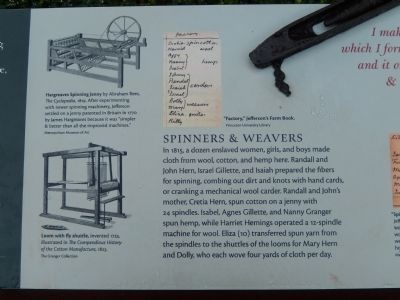
Textiles Marker - Panel 2
GEOGRAPHIC SORT Title Sort Marker Number Sort Marker Number Sort for Trails Publication Order Sort Publication Order Sort A Erected Year Sort Most Viewed Sort Most Recent-Interest Sort Most Recently Changed Sort SEE FAQ #33 FOR DESCRIPTIONS
Near Thomas Jefferson Parkway.
Near Thomas Jefferson Parkway.
On Thomas Jefferson Parkway (Virginia Route 53) at Michie Tavern Lane (County Road 1102), on the right when traveling east on Thomas Jefferson Parkway. Reported permanently removed.
Near Monticello Loop 0.3 miles north of Thomas Jefferson Parkway ( Route 53), on the left when traveling south.
Near Thomas Jefferson Parkway (Virginia Route 53) 0.1 miles east of Michie Tavern Lane ( Route 1102), on the right when traveling east.
Near Thomas Jefferson Parkway (Virginia Route 53) 0.1 miles east of Michie Tavern Lane ( Route 1102), on the right when traveling east.
Near Thomas Jefferson Parkway (Virginia Route 53) 0.1 miles east of Michie Tavern Lane ( Route 1102), on the right when traveling east.
Near Monticello Loop 0.6 miles north of Thomas Jefferson Parkway ( Route 53), on the left when traveling north.
On University Avenue (Business U.S. 250) at Hospital Drive, on the right when traveling west on University Avenue.
On East Market Street (County Road 1105) 0.3 miles south of Riverside Drive, on the right when traveling east.
On East Market Street (County Road 1105) 0.2 miles south of Broadway Street, on the right when traveling east.
Near College Drive just west of Scottsville Road ( Route 20), on the right when traveling west.
Near Monticello Loop 0.3 miles east of Thomas Jefferson Parkway, on the right when traveling east.
On University Avenue (Virginia Route 250) east of McCormick Road, on the left when traveling west.
Near Thomas Jefferson Parkway (Virginia Route 53) just east of Michie Tavern Lane ( Route 1102), on the right when traveling east.
Paid Advertisement
Near Thomas Jefferson Parkway (Virginia Route 53) at Mitchie Tavern Lane (County Road 1102), on the right when traveling east. Reported permanently removed.
On Ivy Road (Business U.S. 250) near Colonnade Drive. Reported permanently removed.
On Ivy Road (Business U.S. 250) just west of Colonnade Drive, on the right when traveling east.
Near College Drive just west of Scottsville Road ( Route 20), on the right when traveling west.
Near Monticello Loop 0.4 miles north of Thomas Jefferson Parkway ( Route 53), on the left when traveling north.
Near Ashlawn-Highland Drive 0.4 miles west of James Monroe Parkway, on the right when traveling north.
Near Ashlawn-Highland Drive 0.4 miles west of James Monroe Parkway, on the right when traveling north.
Near Ashlawn-Highland Drive 0.4 miles west of James Monroe Parkway, on the right when traveling north.
Near Monticello Loop at Thomas Jefferson Parkway ( Route 53), on the left when traveling north.
Near University Avenue (Business U.S. 250) east of McCormick Road, on the left when traveling west.
Near University Avenue (Business U.S. 250) east of McCormick Road, on the left when traveling west.
On Advance Mills Road (County Route 743) at Frays Mill Road (County Route 641), on the left when traveling west on Advance Mills Road.
Near Hydraulic Road (County Road 743) at Hydraulic Ridge Road, on the left when traveling north.
On Belvedere Boulevard 0.1 miles east of Belvedere Place, on the right when traveling east.
On Belvedere Boulevard east of Free State Road, on the right when traveling east.
Paid Advertisement
On Barracks Farm Road (County Route 658) east of Garthfield Lane, on the right when traveling east.
Near Richmond Road (U.S. 250) 0.9 miles east of Exit 124 (Interstate 64).
On Ivy Farm Road (County Route 1015), on the left when traveling east. Reported missing.
On Emmet Street (Business U.S. 29) at Sprigg Lane, on the right when traveling south on Emmet Street.
On Emmet Street North (Business U.S. 29) at University Avenue and Ivy Road (Business U.S. 250), on the left when traveling south on Emmet Street North.
On East Jefferson Street just east of 4th Street Northeast, on the left when traveling east.
On Tyree Lane at Bowles Alley, on the right when traveling east on Tyree Lane.
On Tyree Lane at Bowles Alley, on the left when traveling west on Tyree Lane.
On Oak Street west of 1st Street South, on the left when traveling west.
Near Earlysville Road at Woodlands Road, on the right when traveling south.
On Preston Avenue just west of Albemarle Street, on the right when traveling west.
On Earlysville Road 0.2 miles south of Woodlands Road, on the right when traveling south.
Near Earlysville Road (County Road 743) 0.3 miles south of Woodlands Road, on the right when traveling south.
Near Earlysville Road 0.3 miles south of Woodlands Road, on the right when traveling south.
On McCormick Road at Poe Alley, on the right when traveling south on McCormick Road.
Near McCormick Road south of University Avenue, on the left when traveling north.
Paid Advertisement
Near West Pavilion just north of Constantine Path, on the left when traveling north.
On McCormick Road at Poe Alley, on the right when traveling south on McCormick Road.
Near McCormick Road north of Mews Alley, on the right when traveling south.
On Rotunda Drive west of Hospital Drive, on the right when traveling west.
Near McCormick Road south of University Avenue (Business U.S. 250), on the left when traveling south.
On University Avenue (Business U.S. 250) at Rugby Road on University Avenue.
On Scottsville Road (Virginia Route 20) 0.5 miles south of Frys Path ( Route 627), on the right when traveling north.
On Scottsville Road (Virginia Route 20) just south of Carters Mountain Road (Route 627), on the left when traveling south.
On Scottsville Road (Virginia Route 20) 0.5 miles Frys Path ( Route 627), on the right when traveling north.
Near Woodbrook Drive west of Seminole Trail (U.S. 29).
Near Woodbrook Drive west of Seminole Trail (U.S. 29).
Near Woodbrook Drive west of Seminole Trail (U.S. 29).
On East Market Street (County Road 1105) 0.2 miles south of Riverside Avenue, on the right when traveling east.
On St John Road (Virginia Route 640) 1 mile south of Gordonsville Road (Route 231), on the right when traveling south.
On Monacan Trail Road (U.S. 29) at Lackey Lane (County Route 838), on the right when traveling south on Monacan Trail Road.
On Cove Garden Road (County Route 633) 0.4 miles east of Monacan Trail (U.S. 29), on the right when traveling east.
Paid Advertisement
On Crozet Avenue (Virginia Route 240) at The Square (Local Route 1217), on the left when traveling south on Crozet Avenue.
On Earlysville Road (County Route 743) just south of Advance Mills Road (County Route 663), on the left when traveling north.
On Earlysville Road (County Route 743) south of Advance Mills Road (County Route 663), on the right when traveling north.
On Rio Mills Road (County Route 643) at Seminole Trail (U.S. 29), on the right when traveling west on Rio Mills Road.
On Rio Mills Road (County Route 643) at Seminole Road (U.S. 29), on the right when traveling west on Rio Mills Road.
On James River Road (County Route 626) 0.6 miles east of Chestnut Grove Road (County Route 723), on the right when traveling east.
On Langhorne Road (County Route 626), on the right.
On Louisa Road (Virginia Route 22) 0.1 miles west of Whitlock Road ( Route 616), on the left when traveling west.
On Louisa Road (Virginia Route 22) 0.2 miles east of Cobham Station Lane ( Route 640), on the right when traveling north. Reported missing.
On Greenwood Road (County Route 691) 0.2 miles north of Greenwood Station Road (County Route 690), on the right when traveling north.
On Rockfish Gap Turnpike (U.S. 250), on the right when traveling west.
On Rockfish Gap Turnpike (U.S. 250) east of Plank Road, on the right when traveling east.
On Interstate 64 at milepost 103.5, on the right when traveling east.
On Ivy Road (U.S. 250) at Owensville Road (County Route 678) on Ivy Road.
On Ivy Road (U.S. 250) east of Three Notched Road ( Route 240). Reported missing.
On Ivy Road (U.S. 250) 0.1 miles west of Gillums Ridge Road ( Route 787), on the right when traveling west.
Paid Advertisement
On Gordonsville Road (Route 231) 0.1 miles south of Millwood Lane (County Road 783), on the left when traveling south.
On Louisa Road (Route 22) just west of Keswick Road (County Road 731), on the left when traveling west.
On Louisa Road (U.S. 22) at Keswick Road (County Route 731), on the right when traveling west on Louisa Road.
On Gordonsville Road (Virginia Route 231) 0.1 miles south of Millwood Lane (County Route 783), on the left when traveling south.
On Keswick Road (Route 731) 0.1 miles north of Richmond Road (U.S. 250), on the right when traveling north.
On Virginia Route 231 north of Lindsay Road, on the left when traveling north.
On Miller School Road (County Route 635) close to Dick Woods Road (County Route 637), on the left when traveling south.
On Plank Road (County Route 692) at Monacan Trail Road (U.S. 29), on the right when traveling west on Plank Road.
On Proffit Road (County Route 649) near Mossing Ford Lane (County Route 741), on the right when traveling south.
On East Main Street (Virginia Route 6) east of Valley Street ( Route 20), on the left when traveling east.
On Irish Road (Virginia Route 6) at James River Road, on the right when traveling west on Irish Road.
On Valley Street (Virginia Route 20) at Main Street ( Route 6), on the left on Valley Street.
On West Main Street just west of Valley Street ( Route 20), on the left.
On East Main Street (Virginia Route 6) just east of Valley Street ( Route 20), on the right when traveling east.
On Hardware Street (Virginia Route 795) 0 miles north of Valley Street ( Route 20).
On James River Road (Virginia Route 742) 0.2 miles east of Warren Ferry Road, on the right when traveling east.
Paid Advertisement
On Hatton Ferry Road 0.5 miles south of Hatton Ferry Lane, on the right when traveling south. Reported missing.
On Hatton Ferry Road 0.5 miles south of Hatton Ferry Lane.
On Hatton Ferry Road 0.2 miles south of Hatton Ferry Lane, on the left when traveling south.
On Richmond Road (U.S. 250) at Louisa Road ( Route 22), on the right when traveling west on Richmond Road. Reported permanently removed.
On Richmond Road (U.S. 250) east of Exit 124 (Interstate 64), on the right when traveling east.
︽
15641 entries matched your criteria. Entries 201 through 300 are listed above.
⊲ Previous 100 —
Next 100 ⊳