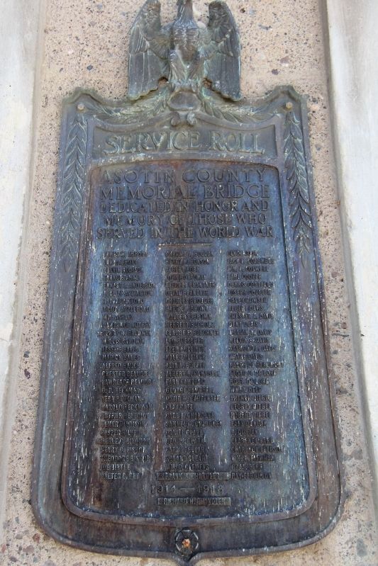
Service Roll
Asotin County
Memorial Bridge
Dedicated in honor and
memory of those who
served in the World War
James W. Abbott • John Abbott • Calvin Addison • Francis Ahalt • Ernest J. Anderson • L. Clift Aplington • R.L. . . . — — Map (db m197096) WM
A Friendly Encounter with People from an Ancient Village
For thousands of years, a Nimiipuu ("the people") village was located a few miles west of here, near the Álpáha (Alpowa) Creek - Snake River confluence. For a . . . — — Map (db m159257) HM
Near Port Way at 9th Street, on the left when traveling east.
On October 10th, 1805, the Lewis & Clark Expedition camped across the river from this park. They called the great river flowing in from the south Lewis' River.
”The Country on either Side is an open plain leavel & Fertile …not a tree of . . . — — Map (db m129075) HM
Near Port Way at 9th Street, on the left when traveling east.
While trekking westwards, the Lewis & Clark Expedition constructed dug-out canoes near the present-day city of Orofino. The Nee Mee Poo or Nez Perce Indians had shown the explorers how to burn out the centers of the Ponderosa pine logs. After . . . — — Map (db m129063) HM
1805
William Clark recorded in his
journal that on this date:
“I can observe at a distance...
a high ridge of thinly timbered
countrey the water of the south fork is greenish blue,
the north as clear as crystial.” . . . — — Map (db m120772) HM
On Inland Empire Highway / Bridge Street (U.S. 12) 0.2 miles east of Elm Street, on the right when traveling east.
Guided by two Nez Perce men, the Lewis and Clark Expedition entered present-day Washington on October 10, 1805. They beached their dugout canoes and camped at a site across the Snake River from here.
In this area, the explorers met, traded with, . . . — — Map (db m129083) HM
Near Granite Lake Drive, 0.2 miles east of 5th Street, on the left when traveling east.
The Lewis and Clark Expedition reached the Clearwater — Snake river confluence on October 10, 1805. The explorers camped across the river from here, their first encampment in present-day Washington. That evening, William Clark wrote about the . . . — — Map (db m129064) HM
"Swifter than any horse could run"
In fall 1805, the Lewis and Clark Expedition raced against time, hoping to reach the Pacific Ocean before winter set in. Traveling faster than at any other time during the journey, the party . . . — — Map (db m159272) HM
On U.S. 12, 2.9 miles west of Westlake Drive, on the right when traveling east.
(left panel – in Asotin County – facing westbound traffic) You are now entering Garfield County over the historic trail traversed by Lewis and Clark on their return from the mouth of the Columbia River, May 4, 1806.
(right . . . — — Map (db m129099) HM
Near U.S. 12, 0.1 miles east of Westlake Drive, on the right when traveling east.
The Nez Perce Indian Nation was comprised of hundreds of separate bands. Chief Timothy, along with Red Wolf, ruled the Alpowa Band whose camp was located where Alpowa Creek meets the Snake River.
Chief Timothy, a Nez Perce Indian Christian . . . — — Map (db m129085) HM
"I gave my hand to them all and made signs of my friendly disposition"
On October 19, 1805, William Clark and three men traveling ahead of the rest of the party arrived at a Umatilla village near here. Upon seeing Clark, the villagers . . . — — Map (db m158634) HM
On Dudley Avenue east of Market Street, on the right when traveling east.
Under the provisions of the National Historic Preservation Act of 1966, this property possesses exceptional value in illustrating American History and Culture Entered in the National Register of Historic Places December 12, 1976 by U.S. Department . . . — — Map (db m129388) HM
On Meade Avenue south of 6th Street, on the right when traveling north.
Founded by Mr. Fred Long in 1901 as the Kash Savin Stor. Moved in 1909 to this Sixth and Meade building constructed in 1904 by E.W.R. Taylor. Renamed The Golden Rule Store between 1910 and 1912.
Mr. T. B. Sampson was employed by the Kash Savin . . . — — Map (db m129390) HM
On East Woodin Avenue east of North Columbia Street, on the right when traveling east.
Log Building Completed 1898 Architect: Kirtland Kelsey Cutter, Spokane
Placed on National Register of Historic Places, 1992
Organized by the Rt. Rev. Lemuel H. Wells,
Bishop of the Spokane Missionary District
who presided at confirmations . . . — — Map (db m129263) HM
On U.S. 97A, 1 mile north of North Lakeshore Drive, on the left when traveling north.
This site on Ribbon Cliff called Broken Mountain by the Indians experienced a violent earthquake in December, 1872. The shock split the mountain, forming the cliff to the west and causing a huge rock slide which stopped the flow of the Columbia . . . — — Map (db m129261) HM
Near U.S. 2 at Coulter Creek Road, on the right when traveling west.
The Native Americans Prehistoric travelers established trails. The first travelers to cross the Cascade Range were the ancestors of today's American Indians. They followed animal trails and natural passageways which eventually became . . . — — Map (db m156201) HM
On Golden West Drive south of Stehekin Valley Road, on the right when traveling south.
In the 1880's and 90's miners ventured up-lake searching for gold, silver, copper, and other metals. Wealth eluded them, but the scenic beauty of Lake Chelan and the Stehekin Valley made a fasting impression on all who passed through.
By 1900 . . . — — Map (db m196820) HM
On Orondo Avenue at Methow Street, on the left when traveling east on Orondo Avenue.
To commemorate the work and achievement of Judge Thomas Burke founder of Wenatchee, and Washington’s first citizen, this enduring tablet is affectionately dedicated by the citizens of Chelan County, to honor him while he is still living among . . . — — Map (db m153400) HM
On South Mission Street (Washington Route 285) north of Yakima Street, on the right when traveling north.
This complex of two buildings - the former federal building and post office - represent the best examples of federal architecture in Wenatchee.
The first federal building was built in 1917 at the corner of Yakima and Mission. It housed the post . . . — — Map (db m197130) HM
Near Upper Hoh Road, 0.1 miles east of Linder Creek Lane, on the left when traveling east.
In the early 19th century what is today the northwest coast of Washington State might have become a Russian colony, an extension of Alaska, if the Sv. Nikolai voyage had been successful. This could have led to this section of New Albion, the . . . — — Map (db m129579) HM
Near Upper Hoh Road, 0.1 miles east of Linder Creek Lane, on the left when traveling east.
Bordered by the Strait of Juan de Fuca and the Pacific Ocean, pre-contact Makah held a vast area of inland and coastal territory. These richly forested lands and the seas which teemed with life offered early Makah a wealth of natural resources. The . . . — — Map (db m129586) HM
On North Forks Avenue (U.S. 101) south of Tillicum Lane, on the right when traveling north.
The Shay locomotive is named for inventor Ephraim Shay of Cadillac, Michigan. The vertical cylinder conveyed power to all the wheels by universal joints and expansion couplings forming a flexible shaft which was rigid in revolution but flexible in . . . — — Map (db m129548) HM
On North Forks Avenue (U.S. 101) south of Tillicum Lane, on the right when traveling north.
In the last 150 years, the West Olympic Peninsula has seen many changes in timber transport.
photo 1: This picture shows a team of oxen hauling logs off a hillside in the 1890s. In the early days of logging on the Peninsula, oxen were . . . — — Map (db m129493) HM
On Straight of Juan de Fuca Highway (State Highway 112) just east of Snow Creek Resort, on the right when traveling west.
Sail and Seal Rocks rise from the seascape in front
of you, where Snow Creek enters the Strait of Juan
de Fuca. This rich and productive marine habitat
attracts fishermen, divers, kayakers—and whales!
Snow Creek overlook is one of the . . . — — Map (db m83679) HM
On Upper Hoh Road, 15.5 miles east of U.S. 101, on the right when traveling east.
The temperate rain forest is dominated by Sitka spruce. Except where it penetrates valley such as the Hoh, the Sitka spruce grows along a narrow coastal strip from northern California to Alaska.
High rainfall, fog, and ocean-moderated . . . — — Map (db m83654) HM
On Olympic Highway (U.S. 101) at Laird Road, on the right when traveling west on Olympic Highway.
According to a seventeenth century account, Apostolos Valerianos discovered a waterway through the northwest corner of North America in 1592 — a Northwest Passage. He reputedly sailed for the Spanish under the name “Juan de Fuca.”
For a . . . — — Map (db m177413) HM
On U.S. 101 just west of Deer Park Loop, on the right when traveling west.
The Spanish Captain Juan Perez sailed north from San Blas in 1774 with orders from Spain to claim the Coast against the Russians. Perez discovered Nootka Sound on the West shore of Vancouver Island and traded with the natives of the Queen . . . — — Map (db m83652) HM
On Straight of Juan de Fuca Highway (State Highway 112) 8.7 miles west of Sekiu, on the right when traveling west.
The landscape of the Strait of Juan de Fuca was
carved out by ice-age glaciers 13,000 years ago.
The retreat of the glaciers created deep fjords which
provide abundant food and habitat for many species
of marine mammals.
By the mid-1900’s, . . . — — Map (db m83693) HM
Near Voice of America Road West, 1.1 miles north of Lotzgesell Road when traveling north.
Lighthouse tender boats supplied the Station by traversing Dungeness Bay from the mainland. At least four docks were built over the years. They were often destroyed by storms.
The original dock was constructed circa 1857. It is unknown if . . . — — Map (db m129695) HM
Near Voice of America Road West, 1.1 miles north of Lotzgesell Road when traveling north.
Approximately 10,000 years ago
Dungeness Spit began to form. The Spit is formed from sand and gravel from the Olympic Mountains carried by the Dungeness River into Dungeness Bay.
Debris is also sloughed off the bluffs to the . . . — — Map (db m129716) HM
On NE 4th Avenue at Dallas Street, on the right when traveling west on NE 4th Avenue.
This memorial is dedicated to all servicemen from the Camas-Washougal area who have died as a result of hostile action since the beginning of the Vietnam War. — — Map (db m58004) WM
Near NW 6th Avenue at Division Street (Alternate Washington Route 14), on the left when traveling east.
In honor of the employees from this division who gave their lives while serving in the armed forces during World War II.
Curtin P Barnett • James F Hagensen • Thelma A Rancore • Jimmie Clark Berg • Wayne A Harwood • Lewis L Ray • Eugene P . . . — — Map (db m58851) HM
Near NE 15th Avenue near NE Dallas Street when traveling east.
The first school in Camas (La Camas) was built prior to 1882. It was replaced by a four room school (with inside plumbing) in 1886. The first school remained on the school grounds until 1907. In 1907 the then Columbia River Paper Company gave the . . . — — Map (db m57954) HM
The Columbia River, located a few miles west of here, was one of the first highways in the West. American Indians used canoes as their principal transportation between camps and villages along the river, carrying fish, roots, berries, baskets and . . . — — Map (db m112963) HM
Hudson’s Bay Company established Fort Vancouver in 1824 within the area of present-day Vancouver, 83 nautical miles from the Pacific Ocean. Forty Wooden buildings were enclosed within a 20-foot high log palisade until the treaty of 1846 set the . . . — — Map (db m8400) HM
On NE 139th Street near NE 20th Ave. Reported permanently removed.
Navy Captain
Harley H. Hall
F-4 Phantom
Listed P.O.W. 1-27-73
The last pilot shot down in Vietnam just 10 hours before final cease fire was signed.
Native of
Vancouver, Washington — — Map (db m8513) HM WM
On Evergreen Highway at SE 164th Avenue, on the right when traveling west on Evergreen Highway.
For centuries Indians used the trail that later became
old Evergreen Highway. Where each creek entered the Columbia River the Indians made camp.
In 1805 Lewis & Clark and their expedition camped on Government Island, a haven for waterfowl. . . . — — Map (db m57879) HM
On C Street Circle, on the right when traveling east.
This rose garden is dedicated
to the memory of
Theodore A. Penland
1849 – 1950
last Commander-in-Chief of
the Grand Army of the Republic
Plaque presented by The Daughters of Union Veterans and the Woman’s Relief Corps, . . . — — Map (db m8401) HM
You are standing on the site of a once-bustling riverfront complex at Fort Vancouver. A boat building operation, blacksmith shop, and tannery filled the air with the sights, sounds, and smells of industry.
A busy place is this. The . . . — — Map (db m12292) HM
Before 1846 American immigrants traveling the Oregon Trail to Fort Vancouver had to make a choice at The Dalles (80 miles upriver from here). They could navigate their own handmade raft or take a Hudson's Bay Company boat down the Columbia River to . . . — — Map (db m12295) HM
Look around you. The scenic spot where you now stand was once the heart of one of the busiest shipping ports west of the Rocky Mountains. From 1825 to 1846, Fort Vancouver's waterfront served as the western economic artery of the Hudson's Bay . . . — — Map (db m12293) HM
Near SE Columbia River Drive near Columbia Shores.
In Recognition of the People Who Have Inhabited this Region for Thousands of Years.
Ilchee Moon Girl
History says she was born along the Columbia River about 1800, daughter of Chinook Chief Concomley and, later, wife of Chief Casinos leader . . . — — Map (db m8422) HM
On May 13, 1849, the United States steamer Massachusetts arrived off the Hudson's Bay Company wharf and unloaded Batteries L and M of the First Regiment of United States Artillery. The first permanent official American presence in the Pacific . . . — — Map (db m12289) HM
On Columbia Street near 3rd Street, on the right when traveling east.
[Panel 1]:Captain George Vancouver Monument
October 31, 1792
Lt. William Broughton
Named This Area
For His Captain
Dedicated
October 31, 1992
[Panel 2]:Boat of Discovery
“…The real story of George . . . — — Map (db m8516) HM
On Columbia Street near 3rd Street, on the right when traveling east.
[Panel 1]:
Capt. George Vancouver, from King’s Lynn, England, at age 35 and with orders from the British Admiralty to explore and chart the West Coast of America, charted hundreds of miles of coast line from California to Alaska. His maps . . . — — Map (db m8515) HM
On Columbia Street at W 6th Street, on the right when traveling south on Columbia Street.
After marrying Amos Short in 1829, Esther (Clark) Short set out on the adventure of her life! Originally from Tioga County, Pennsylvania, Esther Short, who was ½ Algonquin Indian, her husband Amos and 10 children traveled west to Linton, Oregon . . . — — Map (db m64239) HM
On East 5th Street near Fort Vancouver Way, on the left when traveling west.
Planting a garden was one of the first things the Hudson's Bay Company (HBC) did when they established Fort Vancouver. At its height, in the mid-1840s, the garden had expanded to eight acres and provided not only produce but also large numbers of . . . — — Map (db m113945) HM
On E. Evergreen Way at Fort Vancouver Way, on the right when traveling east on E. Evergreen Way.
These Napoleon 12-Poind Light Field Cannons are replicas created by Mountain View High School students during the 1990 to 1992 school years in Vancouver, Washington. They are the property of the City of Vancouver, which supplied materials. This . . . — — Map (db m8519) HM
On E. Evergreen Way at Fort Vancouver Way, on the right when traveling east on E. Evergreen Way.
This monument is presented to the city of Vancouver, Washington by the Congressional Medal of Honor Society, in recognition of the spirit and sacrifice shown by the valiant Medal of Honor recipients now at rest in the Vancouver Barracks Cemetery. . . . — — Map (db m22867) HM
On E. 5th Street, on the right when traveling east.
Even before the advent of a U.S. Army Air Service field at Vancouver Barracks in 1921 and the eventual dedication of “Pearson Field” in 1925, aviation had early hallmarks at Vancouver Barracks.
As part of the 1905 Lewis and Clark . . . — — Map (db m83990) HM
On E. Evergreen Way, on the right when traveling east.
In October 1832, the Japanese cargo ship Hojun Maru set sail from near Nagoya bound for Edo (present day Tokyo). Disabled in a storm off Enshu Nada, the Hojun Maru drifted for fourteen months before running aground on the coast near Cape Flattery, . . . — — Map (db m8423) HM
The history of Pearson Field goes back almost to the origins of mechanized flight itself. The landing site of Lincoln Beachey’s groundbreaking flight across the Columbia River from Portland to Vancouver, during the 1905 Lewis & Clark Exposition, . . . — — Map (db m8406) HM
On E. 5th Street, on the left when traveling west.
[Top marker]:In loving memory of
Howard C. French
Major Air Corps Reserve
1894 – 1938
Dedicated by his comrades of the 321st Observation Squadron
United States Army Air Corps Reserve
[Bottom marker]:
In loving . . . — — Map (db m8962) HM
On E. Evergreen Way at Fort Vancouver Way, on the left when traveling east on E. Evergreen Way.
When the U.S. Army arrived in 1849 to establish a new post on the western frontier, few of the officers could afford to bring their families out to such a remote and lonely command. A thriving community of soldiers, officers, wives, and children . . . — — Map (db m8527) HM
On Officers Row near E. Evergreen Blvd, on the right when traveling west.
Officers Row, a procession of homes for officers and their families, began during the early frontier years when Vancouver Barracks was considered by many to be a remote and lonely assignment. The first officer’s quarters on the Row wer log cabins . . . — — Map (db m8529) HM
On E. Evergreen Way, on the left when traveling east.
Registered National Historic Place
Washington State
Advisory Council on Historic Preservation
Under the provisions of the National Historic Preservation Act of October 16, 1966, this property possesses exceptional value in commemorating or . . . — — Map (db m8523) HM
On 5th Street, 0.1 miles west of Reserve Street, on the left when traveling west.
Pearson Field is the first airport in the Pacific Northwest and one of the
oldest operating airports in the United States. It served as a major military
airfield in the interwar years. In 1905, a dirigible originating from the
nearby Lewis and . . . — — Map (db m153216) HM
On Fort Vancouver Way near Martin Court, on the right when traveling south.
Many employees of Fort Vancouver were of French-Canadian descent, and had been raised as Roman Catholics. Separated by thousands of miles from their home parishe, these men pleaded with the Bishop of Quebec to send them priests.
The Reverend . . . — — Map (db m8964) HM
On E. 5th Street, on the left when traveling west.
Although the U.S. Army allowed civilian aircraft to land at Vancouver Barracks beginning in 1905, military aircraft began operating here in 1921, when the U.S. Army Air Service established a landing field for an aviation forest patrol. The patrol . . . — — Map (db m8405) HM
On Hathaway Road, on the right when traveling west on Hathaway Road.
At the beginning of the 20th century, Vancouver was the headquarters for the Department of the Columbia, a vast administrative unit in the Northwest. The population of the post almost tripled in response to increased military activity both at home . . . — — Map (db m8742) HM
On E. 5th Street, on the right when traveling east.
On June 20, 1937, the world’s attention turned to Pearson Field when a Russian ANT-25 aircraft landed after making the first non-stop flight over the North Pole.
The red and gray, single-engined aircraft “Stalin’s Route” carried over . . . — — Map (db m50830) HM
On Grand Boulevard at E. 6th Street, on the right when traveling north on Grand Boulevard.
In 1824 the Hudson's Bay Company chose this place as the site for a new fort which they named Vancouver in honor of the British explorer, George Vancouver. Little is knowns of this fort as it was moved early in 1829 to its now well-known location . . . — — Map (db m8403) HM
On E. Evergreen Boulevard, on the left when traveling east.
When the U.S. Army arrived at Fort Vancouver in May of 1849, they quickly built nine log cabins for shelter against the upcoming winter. Shown here is the 1850 plan of the two-story post commander’s quarters. It is the only remaining structure built . . . — — Map (db m8499) HM
On Barnes Street at McClellan Road, on the right when traveling south on Barnes Street.
The Infantry Barracks is the oldest surviving structure in Vancouver Barracks proper. It was constructed in 1887, one of three identical buildings built to house individual companies of the 14th Infantry. Though it was built prior to the . . . — — Map (db m8741) HM
On E. Evergreen Boulevard, on the left when traveling east.
As part of a natural reorganization, the U.S. Army returned the headquarters of the Department of the Columbia from Portland, Oregon to Fort Vancouver in 1878. As a result, the Army funded construction of several new buildings on Officers Row, . . . — — Map (db m8959) HM
On Fort Vancouver Way at Anderson Street, on the right when traveling south on Fort Vancouver Way.
This Italianate-Revival style home was built in 1878 for General Oliver Otis Howard, Commanding General of the Department of the Columbia from 1874 until 1880.
This gracious home was considered ”the finest dwelling house north of the . . . — — Map (db m8572) HM
On Barnes Street, on the right when traveling south on Barnes Street.
In 1904, the U.S. Army built a new Post Hospital at Vancouver Barracks as a part of a nationwide effort to modernize its forces. Unlike the previous one, the hospital was constructed with brick to enhance sanitation and boasted a spacious floor plan . . . — — Map (db m8739) HM
On Hathaway Road, on the right when traveling west on Hathaway Road.
Following the nation’s entry into World War I, the American Red Cross was authorized to construct convalescent houses adjacent to military hospitals. These facilities provided recreation away from a hospital atmosphere, and helped boost the morale . . . — — Map (db m8743) HM
On E. Evergreen Way at Officers Row on E. Evergreen Way.
[Side one of six]: Under the influence of Dr. John McLaughlin, Manager of the Hudson Bay Co., civilization of Washington started at Vancouver, A.D. 1825.
[Side two of six]: The first school in Washington was taught by John Ball, at . . . — — Map (db m8383) HM
[Monument front]:
Near this site at Pearson Airfield on June 20th, 1937, three Soviet aviators completed the first non-stop flight from the U.S.S.R. to the U.S.A.
Command Pilot Valeri Chkalov, Co-Pilot Georgi Baidukov, and Navigator . . . — — Map (db m50831) HM
On Hathaway Road near Fort Vancouver Way, on the right when traveling west.
Until the late 19th century, the U. S. Army awarded sales commissions to civilian traders, known as sutlers. Each post or regiment was authorized to appoint one. Described as “a combination of saloon keeper and general store operator,” . . . — — Map (db m8963) HM
Fort Vancouver was the first large scale farming operation n the Pacific Northwest. Beginning in 1825, the Hudson’s Bay Company established a number of farms and dairies in the area to reduce the high cost of importing food from England.
. . . — — Map (db m92620) HM
On E. 5th Street near Davis Avenue, on the right when traveling west.
General U.S. Grant
when a young officer was stationed at Columbia Barracks, Vancouver, Washington.
One mile east from here he planted potatoes to reduce the expense of his officer’s mess. — — Map (db m8424) HM
On E. Evergreen Way, on the right when traveling east.
On May 13, 1849, from the deck of the USS Massachusetts, the first U.S. Army troops in the Pacific Northwest spotted the Hudson’s Bay Company’s Fort Vancouver. “Mr. Douglas, the resident Governor received us very politely and Major . . . — — Map (db m8496) HM
On East 5th Street near Fort Vancouver Way, on the left when traveling west.
The London-based Hudson's Bay Company established and extensive fur trading network throughout the Pacific Northwest, utilizing two dozen posts, six ships, and about 600 employees during peak seasons. Fort Vancouver was the administrative center and . . . — — Map (db m113943) HM
On E. Evergreen Boulevard, on the right when traveling east.
This anchor was dredged from the Columbia River in 1960 near Fort Vancouver’s wharf, one-quarter mile east of the Interstate 5 bridge. The anchor gives some answers about its history, but poses many more questions.
It is a Rogers Paten Small-Palm . . . — — Map (db m8691) HM
On Main Street near E. 40th Street, on the right when traveling north.
Erected 1848 by Richard and Anne Charlotte Covington on Fourth Plain. Boarding school was conducted herein in 1850. This building housed first piano in the Oregon Country and was center of social activity in entire region. — — Map (db m8517) HM
On East Main Street at North Front Street, on the right when traveling east on East Main Street.
Ancient Passage Between the Rivers
On the advice of the Walla Walla people, the Lewis and Clark Expedition followed "a good road...plenty of Deer and Antilopes" that led travelers overland between there Columbia - Walla Walla and . . . — — Map (db m159023) HM
On Patit Road at Ronan Hill Road, on the right when traveling east on Patit Road.
"in a little bottom"
The Lewis and Clark Expedition camped in the small valley below this viewpoint on May 2, 1806. The Expedition included thirty-three people from diverse backgrounds and cultures. Known as the Corps of Volunteers . . . — — Map (db m159067) HM
On U.S. 12 near Chandler Road, on the left when traveling east.
The first vegetable processing plant in Dayton was constructed by Blue Mountain Canneries, Inc. in 1934. The plant was constructed in only 45 days, and on the 46th day, it made its first run with a green pea canning trial. When the plant first . . . — — Map (db m159019) HM
On East Main Street near North Front Street, on the right when traveling east.
This land will always be home to the Cayuse, Umatilla and Walla Walla people. The land is used by and shared with relatives and neighbors such as the Palouse, Wanapum, Yakama, Wishxam, Wyam, Tenino and Nez Perce.
In 1805 and 1806, Lewis . . . — — Map (db m159022) HM
On East Main Street west of North 3rd Street, on the right when traveling west.
Columbia County Courthouse: 1887 Washington’s Oldest Courthouse.
Construction of the Territorial Courthouse was completed two years before Washington became a state in 1889.
Designed by local architect W.H. Burrows, the courthouse was . . . — — Map (db m129474) HM
On East Main Street west of North 3rd Street, on the right when traveling west.
Palouse Indians To supplement a diet of salmon, families migrated from riverside “mat lodge” villages to the mountains for game, roots, and berries. “Appaloosa” horses played a paramount role in tribal life.
. . . — — Map (db m129473) HM
On North Front Street at East Commercial Street Avenue, on the left when traveling north on North Front Street.
The Spanish-American War was fought between the United States and Spain over a span of 3 months, 3 weeks, and 2 days: April 21, 1898 to August 13, 1898. Battle occurred in the Spanish colonies of Cuba, Puerto Rico, the Philippines, and Guam. . . . — — Map (db m159021) HM
On Kendall Skyline Road near NF-4620 (Route 4620), in the median.
This scenic mile-high road completed in 1928 was conceived, promoted, surveyed and built under the direction of William H. Kendall who was employed by the U. S. Forest Service from 1907 to 1931.
Before the road was built Kendall was hunting in . . . — — Map (db m113459) HM
Kendall Skyline Road
This scenic mile-high road completed in 1928, was conceived,
promoted, surveyed, and built under the direction of
Wm. H. Kendall
to whose memory it is dedicated by the people he
served so well and by the United . . . — — Map (db m232674) HM
On Tucannon Rd, 1 mile north of Majorie Road, on the left when traveling north.
Columbia County Washington
“Saturday, May 3d, 1806”
The Corps of Discovery crossed the “high plains” and descended to this location after a cold morning of rain, snow, and hail. They described the Kimooenim Creek . . . — — Map (db m118600) HM
Near East Commercial Street Avenue near North 2nd Street, on the right when traveling east.
Built in 1881 across the Touchet River by the Oregon Railroad and Navigation Co. the Union Pacific Railway bought the railroad in 1889. It moved the depot to its present site, on roller logs which were pulled by horse and winch. The stationmaster . . . — — Map (db m158961) HM
Near U.S. 12 near Timpey Road, on the right when traveling east.
In early May of 1806, Lewis and Clark and the Corps of Discovery passed through here on their return from the Pacific Ocean heading eastward. They would complete their epoch making journey with their arrival in the frontier town of St. Louis on . . . — — Map (db m158959) HM
On Patit Road at Ronan Hill Road, on the right when traveling east on Patit Road.
"Friday, May 2d, 1806"
The Corps of Discovery camped near this spot with fair weather and a southwest wind on their return to St. Louis. They recorded seeing deer, sandhill cranes, beaver, and otter. There was camas in bloom along the . . . — — Map (db m159068) HM
On Patit Road at Ronan Hill Road, on the right when traveling east on Patit Road.
1. Pvt. William E. Bratton; Blacksmith, gunsmith, skilled hunter, plant forager and messenger. Resting - bad back.
2. Jean Baptiste Charbonneau; Nick-named Pompey or Pomp. Son of Sacagawea and Toussaint Charbonneau.
3. Toussaint Charbonneau; . . . — — Map (db m159069) HM
On North 2nd Street at East Commercial Street Avenue, on the right when traveling north on North 2nd Street.
By 1899, this intersection was busy with railroad commerce. Northern Pacific and Union Pacific RR depots were across Commercial Street from each other with three sets of train tracks in between. Two or more passenger trains left each depot . . . — — Map (db m158963) HM
On North Front Street at East Commercial Street Avenue, on the left when traveling north on North Front Street.
Built in 1900, this country schoolhouse was originally located in Smith Hollow, eight miles north of Dayton. It served grades 1 thru 8 in the Smith Hollow School District #24 until 1933, when the district was consolidated with Dayton.
On into . . . — — Map (db m159020) HM
On North 1st Street at East Commercial Street Avenue, on the right when traveling north on North 1st Street.
The Celilo Falls Trail, now known as The Nez Perce Trail passed through Dayton near this site. For centuries this was the path used by the Indians, trappers, missionaries and the new settlers. Most notable was the Lewis and Clark Corps of Discovery. . . . — — Map (db m158967) HM
On U.S. 12 near Chandler Road, on the left when traveling east.
Before you on the hillside above the Touchet River Valley is a 300-foot tall Green Giant, placed there in 1993 by employees of the Green Giant Company and local volunteers. His outline and partial vest are made of painted paving blocks. These . . . — — Map (db m158960) HM
968 entries matched your criteria. The first 100 are listed above. Next 100 ⊳