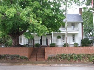
The Newman House was restored and presented in 1995 to the citizens of Waterloo by Ezra Lee Culver, as a memorial to his wife, Edith Elizabeth Newman Culver.
Built in 1872 by Hiram L. and Julia Ann Young Richardson. This house was purchased in . . . — — Map (db m29276) HM
At this site from mid-January to mid-March 1865, Maj. Gen. James Harrison Wilson, U.S. Army, assembled the largest cavalry force ever massed in the western hemisphere. Five divisions totaling 22,000 camped from Gravelly Springs westward to . . . — — Map (db m32770) HM
Side A
One of Alabama's oldest and most picturesque town cemeteries, this site was set aside as a burying ground by the Courtland Land Company in its original survey made prior to the incorporation of the town in 1819. Many of the area's . . . — — Map (db m84304) HM
Side A
This circa 1820 house is thought to be one of the oldest houses in Courtland. Occupying a lot platted by the Courtland Land Company in 1818, the house faces North toward what was once the main Tuscumbia Road. Dr. Jack Shackelford . . . — — Map (db m84306) HM
(front)
Dedicated to the men of Lawrence County, Alabama,
from all walks of life, who left kith and kin,
hearth and home, and lost their lives in military service
for the Confederate States of America during
the War for Southern . . . — — Map (db m84311) WM
General Leroy Pope Walker was born 7 Feb 1817 in Madison County, Al., son of John W. Walker (1784~1823). John was House Speaker of the AL Territory, the first constitutional convention president, the first US AL senator, and namesake of Walker . . . — — Map (db m69669) HM
Born on this site about 1820 to Phillip and Sarah Roddy, Phillip Dale Roddy grew up in poverty. His father a saddle maker and War of 1812 veteran, was one of the earliest murder victims in Moulton. Phillip Dale was raised by his mother and received . . . — — Map (db m69674) HM
Built between 1818 and 1820 with slave labor by William Leetch,
the house was constructed of hand-hewed logs and covered with
wood siding soon after. William's wife, Naomi Knox Leetch, was
visited here by her nephew, future President James Knox . . . — — Map (db m201348) HM
On 26 Apr 1863, a Union raiding party of 1500 including the 51st and 73rd IN, 3rd OH, 18th IL, and local men from two companies of the 1st AL Calvary left Tuscumbia for Russellville. Led by Col. Abel Streight, their objective was to cut Confederate . . . — — Map (db m84318) HM
(side 1)
This small dwelling is the last reminder of "Boxwood" plantation, the home of the Elliot family, and later of the Nevilles. Built-in 1854 of slave-made brick and occupied by the household servants it is one of the few brick . . . — — Map (db m114719) HM
Side 1
Auburn
1865~Present
Only one house was built in the village in the decade after the Civil War, and though the state took over the bankrupt college in 1872, the institution received no state appropriation until 1883. . . . — — Map (db m79947) HM
Auburn First Baptist Church's history dates to June 19, 1838. The first church
structure was a log building erected on the north side of West Glenn Avenue
on land donated by Judge John Harper, the Methodist founder of the town of
Auburn. Land for . . . — — Map (db m183941) HM
Side A:
The University Chapel is the oldest public building in the city of Auburn. Built as a Presbyterian Church, the first service was held in the original Greek Revival-style building on September 13, 1851. Edwin Reese, spiritual leader . . . — — Map (db m39831) HM
(Side 1)
This simple frame structure was built by newly freed black men and women before 1870. The property on which the building stands was given to a member of the Ebenezer congregation in 1865, the year the War Between the States . . . — — Map (db m74450) HM
At the Auburn train depot on February 16, 1861, Jefferson Davis reviewed the Auburn Guards, the first Confederate military company thus honored. Davis was en route to his inauguration as President of the Confederacy. The Auburn Guards were comprised . . . — — Map (db m74455) HM
The East Alabama Methodist College occupying this site was used as a Confederate hospital
1864 • 1865
1888
Alabama Polytechnic Institute
Agricultural & Mechanical College
Burned June 24, 1887. — — Map (db m183920) HM
Built in Selma, Alabama, during the early part of the Civil War for the manufacture of military supplies for the Confederate Army. During the war an attempt was made to move it to Columbus, Georgia to prevent its being seized by Federal troops. En . . . — — Map (db m39815) HM
North side
To Our Confederate Dead
and Lee County Veterans
West side
"Nor Shall Your Glory
Be Forgot, While Fame
Her Record Keeps,
Or Honor Points
The Hallowed Spot,
Where Valor
Proudly Sleeps!
Easts . . . — — Map (db m176385) WM
Opelika A Railroad Town
Opelika's original name was Opelikan when the town was founded in the 1830s. In 1850, the name was respelled as Opelika. In 1851, the Montgomery & West Point Railroad Company extended its Montgomery to Opelika rail line . . . — — Map (db m184077) HM
obverse
The Railroad Avenue Historic District was the downtown nucleus of Opelika when the city was incorporated as part of Russell County, Alabama in February, 1854. The city limits extended a mile in every direction from the Montgomery . . . — — Map (db m85336) HM
With orders from Gen. Sherman, Gen. Lovell Rousseau left Decatur with 2,700 cavalry, beginning his raid into East-Central Alabama. That raid ended successfully in Opelika July 19, 1864, after miles of track were destroyed along with other railroad . . . — — Map (db m75126) HM
created Feb. 6, 1818 by Alabama Territorial Legislature from lands ceded by Cherokee Nation 1806 and by Chickasaw Nation in 1816. Named for creek (and its limestone bed), which runs through county.
Few settlers here until Indian treaties.
Athens . . . — — Map (db m29109) HM
This church was organized in 1829 as a Cumberland Presbyterian church by the Revs. Robert Donnell, John Morgan and Allen Gipson.
After first using an interdenominational building, a church was built on West Washington street in 1852.
This was . . . — — Map (db m85386) HM
On May 2, 1862, Union troops of the 19th and 24th Illinois and the 37th Indiana Regiments commanded by Col. John Basil Turchin went on a rampage through the town. They looted and plundered stores and homes, stealing clothing, jewelry and anything of . . . — — Map (db m85387) HM
Athens was incorporated in 1818, one year prior to the admission of Alabama as the 22nd state. It is the seat of Limestone County, created by an act of the Alabama Territorial Legislature. Athens has a legacy of providing quality education for . . . — — Map (db m159697) HM
This stone marks the site
of the surrender of
Col. Wallace Campbell U.S.A.
to
Gen. Nathan Bedford Forrest C.S.A.
Sept. 24, 1864
Erected by N.B. Forrest Chapter
Alabama Div. U.D.C. 1902
In commemoration of the
triumph of their . . . — — Map (db m154212) HM WM
Wealthy and influential Virginia family settled here in 1820's. Daniel Coleman (1801-1857) built his stately home a block west about 1826. During the Civil War, home was occupied by Yankee troops who took Elizabeth Coleman's teeth for their gold . . . — — Map (db m85389) HM
“My people were in slavery on the Coleman
Plantation. When the war came, they had an
opportunity to fight for their freedom on that
very same spot. Then Trinity was built at the
fort, and they could get an education there.
That story . . . — — Map (db m158197) HM
The Confederate Circle in Athens City Cemetery contains graves of over 50 soldiers killed in or around Athens during the WBTS, 8 unknown. Around 1898 ladies of the local UDC were working in the cemetery when bones, believed to be soldiers, were . . . — — Map (db m94159) HM
Left, top: Athens citizens celebrated the unveiling of the first Confederate monument in 1909. Due to objections to the bowed head, which suggested defeat, a second statue was ordered.
Left, center: Watermelon rinds litter the . . . — — Map (db m154206) HM
From the 1850s to the 1970s, the Louisville & Nashville Depot was located between Market and Washington streets. The building has been used as a dress ship, a photographer's studio, and in 2004 was remodeled for the Limestone County Archives. . . . — — Map (db m93878) HM
Fort Henderson Built on this site in 1863 by federal forces occupying Athens. It was a five-sided earthen fort with some frame buildings and underground bomb-proofs. Abatis lined the fifteen-foot deep perimeter ditch, a small portion of which . . . — — Map (db m41787) HM
Lentzville Cemetery began as the family cemetery for the family of John Henry Lentz (7 Feb 1753-18 Jul 1835) and his wife Savilla. John Henry was a veteran of the American Revolution and pioneer settler of Limestone County, entering his land in . . . — — Map (db m114306) HM
[Front]
Confederate
soldiers
of
Limestone County
[Side]
In memory of
Limestone's sons
This monument is erected
by their survivors
and
Joseph E. Johnston
Chapter U.D.C.
1909
[Side]
Ennobled by . . . — — Map (db m156910) WM
The second Confederate Monument was erected in June 1912. This view shows the intersection of Market and Marion streets.
The 4-H'ers parade their cattle on the courthouse lawn in 1959. Judges were on hand to give a blue ribbon for the best . . . — — Map (db m93881) HM
Built abt. 1849 by Rev. Robert Donnell, a native of North Carolina, and his second wife Clara Lindley Donnell. He was greatly inspired by the Great Spiritual Revival of 1800 and became a Presbyterian circuit rider, one of the "flaming fires," so . . . — — Map (db m72159) HM
“When told that the fort had been surrendered...
[the soldiers] could scarcely believe themselves,
but with tears demanded that the fight should
go on, preferring to die in the fort.” — Lt.
Robert McMillan, 110th U.S. . . . — — Map (db m158258) HM
“Trinity School founder Mary Fletcher Wells
and the American Missionary Association
forged the path for reconstruction in Limestone
County's African American population in an
approach based on the belief that education
and religion . . . — — Map (db m158194) HM
“Just after daylight on the morning of
September 24, they opened on the fort with
artillery from three different sides, casting
almost every shell inside the works.” — Col.
Wallace Campbell, 110th U.S. Colored . . . — — Map (db m158261) HM
"The fort...was one of the best works of the kind I
ever saw.” — Lt. Henry March, 115th Ohio, USA
Here you can see all that remains of Fort Henderson,
the southeast bastion. Envision standing here during
construction. The . . . — — Map (db m158265) HM
This cistern is the last remnant of Trinity School located here 1865-1907. The cistern was used to store rainwater collected from the roof. No physical evidence remains of the Ross Hotel, the Chapman Quarters, and other buildings on this block, . . . — — Map (db m72219) HM
On Sept. 25, 1864 Gen. N.B. Forrest's Confederate cavalry, with Morton's battery of 4 guns, attacked and captured the Union fort near here. The fort consisted of a square redoubt, rifle pits, two blockhouses, and some frame buildings. It protected a . . . — — Map (db m60870) HM
Front The earliest settlers to this area moved across the Chickasaw boundary before 1810 and established the Sims and New Garden settlements. The area came to be known as Elkmont, for the once abundant elk, the Elk River and the "mount" on . . . — — Map (db m85426) HM
(Side A)
Old New Garden Cemetery
This cemetery is one of the oldest in Limestone County and is listed on the Alabama Historic Cemetery Register. Many of the areas earliest settlers are buried here including Patsy Elmore, widow of a . . . — — Map (db m73836) HM
Soon after this scene was captured of Union troops rebuilding Sulphur Creek Trestle, one mile south of here, in early 1864, the ring of hammers was replaced by the thunder of cannon fire. By the time the smoke cleared, more than 240 men were dead in . . . — — Map (db m154183) HM
The first known burial here is Charles Cunningham who died September 28, 1852. Many unmarked fieldstones are present that could mark older graves. The cemetery contains 82 identifiable burials with headstones. Six Confederate soldiers, WWI, and WWII . . . — — Map (db m98753) HM
The first known burial here is Nancy Vinson Christopher who died May 16, 1852. Many unmarked fieldstones are present that could mark older graves. The cemetery contains 52 identifiable burials with headstones. Five Confederate soldiers and one WWII . . . — — Map (db m71991) HM
Hemmed in by superior forces Forrest's fast~moving cavalry raided and destroyed Union supply lines and strong points, captured 2,360 men, valuable stores.
By swift action, surprise and bluff Forrest disrupted Union military plans from Decatur to . . . — — Map (db m29104) HM
(front)
1861-1865
The Soldier Dead
of Lowndes
(left side)
No men died there
with more glory.
Yet many died,
And there was much glory.
(right side)
To
Devotion and Valor. . . . — — Map (db m68342) WM
Settled before 1820 by planters from South Carolina and Virigina. First called McGill's Hill, it was incorporated, 1832, as Lowndesboro in honor of William Lowndes. There was a brief skirmish here between Forrest's troops and Wilson's raiders, April . . . — — Map (db m70933) HM
In Honor of
Our Confederate Soldiers
1861 1865
Jno Alexander • Wm. Alexander • Wm. H. Alexander • Ed Alexander • Capt. M.F. Bonham • Maj. Bright • Capt. T.B. Brown • Alberta Caffee • Irvin Crocheron • J.P. Caffee • Jim Crocheron • Jno. . . . — — Map (db m85472) WM
The camp on this site served as a military hospital, a camp of conscription and instruction, a supply depot, and a cemetery during the War Between the States. At one time, there were hundreds of headstones and rocks marking the final resting place . . . — — Map (db m73529) HM
This cemetery was founded in 1900 when Francis Marion Whatley and Emma Whatley buried their daughter, Ophelia. A son of Simeon Whatley, Francis was a Confederate prisoner of war veteran. He was a prominent landowner, farmer, and cotton gin and . . . — — Map (db m204230) HM
In July 1864, Union Gen. Wm. T. Sherman sent Maj. Gen. L.H. Rousseau
to Alabama with 2500 cavalry to cut the rail link remaining to
Confederates defending Atlanta: the West Point & Montgomery
Railroad. On 18 July, 3 Union units arrived at Chehaw . . . — — Map (db m223941) HM
At the time we occupied the place there were standing upon it a cabin, formerly used as the dining room, an old kitchen, a stable, and an old hen-house. Within a few weeks we had all of these structures in use.
—Booker T. . . . — — Map (db m101916) HM
Located on land owned by John Gurley, pioneer settler, and named for him. His son, Capt. Frank B. Gurley, became a Confederate hero as a member of the 4th Ala. Cavalry. The settlement that developed around the water tank on Memphis and Charleston . . . — — Map (db m30574) HM
In this house John Hunt Morgan was born June 1, 1825. This dashing cavalry leader of the Confederacy was killed at Greeneville, Tenn., Sept. 4, 1864. This house, built in 1823, was the home, 1849-1949, of the heirs of Stephen Neal, Madison . . . — — Map (db m32556) HM
After the Civil War, the future of African-Americans in the United States Army was in doubt. In July 1866, Congress passed legislation establishing two cavalry and four infantry regiments to be made up of African-American soldiers. The mounted . . . — — Map (db m75092) HM WM
I am Private Patrick O’Hara of the 20th Maine Volunteer Infantry Regiment. Before the war I was a fisherman working on a boat out of Bar Harbor, Maine. I didn’t volunteer for the Army until well into the second year of the war because it was way . . . — — Map (db m85490) WM
Erected on November 21, 1905, a handsome monument was dedicated to the Confederate dead by the Virginia Clay Clopton Chapter #1107 United Daughters of the Confederacy of Huntsville, and was unveiled with proper ceremonies in which many veterans of . . . — — Map (db m27784) HM
Methodist Society organized at Hunt’s Spring prior to formation of Madison County, served 1808-1820 by Flint Circuit traveling ministers. First Church built 1821 NW corner Clinton and Gallatin Streets. Present site acquired 1832, church completed . . . — — Map (db m27790) HM
George Gilliam Steele, one of Huntsville's preeminent architects, designed and built Oak Place as his country residence circa 1840 on 320 acres.
An outstanding example of Early Greek Revival architecture, it was unique for the period with its . . . — — Map (db m154278) HM
Memphis and Charleston Railroad Company Eastern Division headquarters in this passenger depot, adjoining yards and ships captured by Union Army April 11, 1862. Vital east-west Confederate rail link severed; C.S.A. soldiers imprisoned here. Depot . . . — — Map (db m85547) HM
Chartered in 1812. Leading educational Institution. Long prominent in training leaders of North Alabama. Occupied by Federal troops, 1862. Building burned, 1864. Site of city schools since 1882. Location used only for school purposes. Alabama . . . — — Map (db m55724) HM
During the original Madison County Land Sales of 1809, LeRoy Pope of Petersburg, GA, secured among other purchases a majority of Section 36, Township 3, Range 1 West, the site of the future town of Twickenham, as Huntsville was originally known. . . . — — Map (db m32480) HM
Thomas Bibb, first president of the Alabama Senate and second governor of Alabama, completed this early high-style Greek revival house in 1836, having occupied the land since 1821. This was his town residence, his plantation home being Belmina, in . . . — — Map (db m160635) HM
Well known spring in the 1800's where travelers watered horses and livestock before crossing Monte Sano on Big Cove Pike. In late 1863, Captain Lemuel Mead's Partisan Rangers attacked railroads, wagon trains, and forage parties behind enemy lines in . . . — — Map (db m80774) HM
[Front] The largest engagement of the Civil War in Madison County was fought during a driving rainstorm here at the site of the railroad depot. Under the command of Col. Josiah Patterson, the Confederate forces (~1000 cavalry and a battery of . . . — — Map (db m85836) HM
This site was the farm of Gilbert G. White Jr., his wife Nancy L. White, and family from 1947 to 2005. Mr. White lived here until his death in 1978. Gilbert G. White Jr. was a descendant of John White, Speaker of the US House of Representatives . . . — — Map (db m44268) HM
Originally known as Cloud's Town, this community was incorporated in 1832 as Vienna. It prospered as a market town before the Civil War. On May 29, 1864, the 12th Indiana Cavalry, commanded by Lt. Col. Alfred Reed, seized the town. They built a . . . — — Map (db m71347) HM
Side A
On July 19, 1847, Chistopher and Mary Harless Sears deeded two acres (with meeting house, brush-arbor, and camp-stand) to the Elders of the Walnut Grove Society of the Cumberland Presbyterian Church for one penny. The Union Army . . . — — Map (db m71343) HM
Buckhorn Tavern
Located in Section 18, Township 2, Range 2 East, this site was an early wayside stop for pioneer settlers as they traveled the road from Winchester, Tennessee into Madison County. The tavern predates the creation of the . . . — — Map (db m155018) HM
2 miles N.W. on old Limestone Road during a skirmish August 5, 1862 Federal General Robert L. McCook was killed by men of Capt. Frank Gurley's Confederate unit. In retaliation, the Federal forces burned and pillaged the area. — — Map (db m31644) HM
Situated on historic White Bluff
overlooking the Tombigbee River,
Bluff Hall was built in 1832 by
slaves of Allen Glover for his
daughter, Sarah Serena, and her
husband, Francis Strother Lyon.
Lawyer and planter, F. S. Lyon, served in both . . . — — Map (db m37997) HM
In Memory of Re-Union 6th and 7th August 1904
Managers: Probate Judge Wm. R. White and Hon. Mack Pearce
Guest Speakers
Ex-rept. Wm. C. Davis, Hamilton - later Lieut. Gov. Ala.
Ex-Rept. Wm. W. Brandon, Tuscaloosa - later Governor, Ala. . . . — — Map (db m80883) HM WM
Side 1
Hamilton was established on November 17, 1882 and was named in honor of Capt. Albert James Hamilton. Hamilton was first known as "Toll Gate," named for a toll gate on the Jackson Military Road. The original county seat of Marion . . . — — Map (db m96479) HM
The First Alabama Cavalry U.S. Army
Organized July 12, 1862 - Deactivated October 20, 1865
Huntsville, Alabama
Colonel George E. Spenser, Commander
Organized by special order No. 100 by Major General Don Carlos Buell of U.S. Army. Over . . . — — Map (db m80884) HM WM
The City of Albertville traces its origin here to 406 East Main Street, where on Jan. 13, 1860, James C. Miller (1833-1862) established a post office in his log cabin home, which also doubled as the community’s first store. Miller, who was later . . . — — Map (db m78710) HM
28-29, July, 1862 Guntersville shelled-burned by Union Artillery, Cavalry and Infantry.
Skirmish at Fearn's, Law's, Matthew's Landings and Ft. Deposit.
1, May 1862 - Sand Mountain Cavalry Battle - CSA Gen. Forrest - Union Col. Streight. . . . — — Map (db m235559) HM
On January 15, 1865 an early morning clash occurred here on the Thomas Noble farm between Federal forces led by col. William J. Palmer’s 15th Pennsylvania Cavalry of 180 men and Confederate Gen. Hylon B. Lyon’s 250 men from two Kentucky cavalry . . . — — Map (db m210725) HM
January 15, 1865 was perhaps the darkest day in the history of Guntersville. At noon, forty Federal marines from the gunboat U.S.S. General Grant were sent to burn the town. After the mission was completed, only seven buildings remained standing – . . . — — Map (db m227313) HM
The hill to the immediate left was the site of the 1862 shelling of Guntersville during the War Between the States.
On July 28, 1862, a Federal force under the command of Major J.W. Paramore placed two Parrott guns on the hill and shelled . . . — — Map (db m203196) HM
The first major attack on Guntersville during the Civil War occurred on the morning of Monday, July 28, 1862. The Federals had marched by night and had reached a hill on the north side of the Tennessee River and from this vantage point aimed their . . . — — Map (db m22253) HM
On April 30, 1865, C.S. General Richard Taylor, by then back in Meridian, received a wire from U. S. General Edward Canby. The truce negotiated at Magee Farm, Canby informed him, must end in 48 hours, because Washington had rejected the . . . — — Map (db m126690) HM
Here on May 4, 1865 Lt. Gen. Richard Taylor, C.S.A. surrendered the last organized Confederate forces, the Department of Alabama, Mississippi and East Louisiana, to Major Gen. E.R.S. Canby, U.S.A. thereby bringing to an official close the War . . . — — Map (db m126730) HM
The Confederates built Fort Powell on Tower Island, an oyster shell bank fifty feet north of Grant's Pass. The Pass provided an easy route from Mobile Bay to New Orleans through Mississippi Sound. C.S. Lieutenant Colonel James M. Williams, only . . . — — Map (db m87239) HM
Once Farragut was in the Bay, capture of Fort Gaines and Powell would prevent his isolation there. So at 4:00 pm, August 3, 1864, 1,500 soldiers commanded by U.S. General Edward Canby (but under the operational direction of General Gordon . . . — — Map (db m87219) HM
At 7:25 a.m., August 5, 1864, Admiral Farragut’s lead monitor Tecumseh steered into the torpedo field at the mouth of Mobile Bay. The admiral had ordered Commander Tunis Craven, the Tecumseh’s captain, to engage the ram . . . — — Map (db m87234) HM
This anchor came from the U.S.S. Hartford, Admiral Farragut's flagship during the Civil War "Battle of Mobile Bay" in August of 1864. It was there that he uttered the now famous words, "Damn the Torpedoes—Full Speed Ahead!" — — Map (db m87244) HM
This island, rich in history and legend, was
known to Europeans by 1502. Pineda visited in
1519, Narvaes and deVaca in 1528, the fleet of
deSoto in 1540, and the deLuna colonists in 1559.
In 1699, d'Iberville and Bienville arrived under
orders . . . — — Map (db m226727) HM
Established in 1821 for defense of Mobile Bay and named in honor of General Edmund Pendleton Gaines, 1777-1849 who played an important part in early Alabama History and while Commandant of Fort Stoddard captured Aaron Burr near McIntosh in February . . . — — Map (db m39393) HM
To Wait and Watch
In late August 1864 the Federals controlled Mobile Bay but could not attack Mobile. Admiral Farragut could not reach the City even with his light draft vessels, because the channels in the upper Bay had been obstructed. . . . — — Map (db m87243) HM
(preface)
"Damn the Torpedoes!" is a familiar battle cry, but there's more to the story! The Mobile Civil War Trail is your guide to military movements and the way of life on and around Mobile Bay in the closing two years of the Civil . . . — — Map (db m87288) HM
585 entries matched your criteria. Entries 301 through 400 are listed above. ⊲ Previous 100 — Next 100 ⊳